


-
[Name]: Amboy Crater
[Image]:
[Date]: May 1973
[Location]: 34°31′11.69″N 115°43′26.92″W / 34.5199139°N 115.7241444°W / 34.5199139; -115.7241444
[County]: San Bernardino
[Ownership]: Federal (Bureau of Land Management)
[Description]: A 6,000-year-old volcanic cinder cone, made up of pahoehoe, just off historic U.S. Highway 66. -
[Name]: American River and Phoenix Park Vernal Pools
[Image]: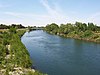
[Date]: 1976
[Location]: 38°39′10.33″N 121°12′59.95″W / 38.6528694°N 121.2166528°W / 38.6528694; -121.2166528
[County]: Sacramento
[Ownership]: Mixed- county, private
[Description]: Contains vernal pools, and blue oak woodlands. -
[Name]: Año Nuevo State Reserve
[Image]:
[Date]: 1980
[Location]: 37°7′7.24″N 122°18′24.02″W / 37.1186778°N 122.3066722°W / 37.1186778; -122.3066722
[County]: San Mateo
[Ownership]: State (California Department of Parks and Recreation)
[Description]: One of the largest mainland breeding grounds for the northern elephant seal. -
[Name]: Anza-Borrego Desert
[Image]: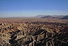
[Date]: 1974
[Location]: 33°14′57.38″N 116°24′24.63″W / 33.2492722°N 116.4068417°W / 33.2492722; -116.4068417
[County]: Imperial, Riverside, San Diego
[Ownership]: State (California Department of Parks and Recreation)
[Description]: The largest desert state park in the nation. -
[Name]: Audubon Canyon
[Image]:
[Date]: 1968
[Location]: 37°55′46.01″N 122°40′55.85″W / 37.9294472°N 122.6821806°W / 37.9294472; -122.6821806
[County]: Marin
[Ownership]: Private
[Description]: The largest known nesting area for great blue herons and great and snowy egrets on the Pacific Coast. -
[Name]: Black Chasm Cave
[Image]:
[Date]: 1976
[Location]: 38°26′3.4″N 120°37′35.3″W / 38.434278°N 120.626472°W / 38.434278; -120.626472
[County]: Amador
[Ownership]: Private
[Description]: A small three-level cave containing a variety of speleothems and some of the best helictite formations in the western U.S. -
[Name]: Burney Falls
[Image]: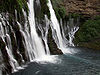
[Date]: 1984
[Location]: 41°0′43.79″N 121°39′7″W / 41.0121639°N 121.65194°W / 41.0121639; -121.65194
[County]: Shasta
[Ownership]: State (California Department of Parks and Recreation)
[Description]: Contains some of the best examples in the western United States of a river drainage regulated by stratigraphically-controlled springs. -
[Name]: Cima volcanic field
[Image]:
[Date]: 1973
[Location]: 35°17′21.95″N 115°35′6.99″W / 35.2894306°N 115.5852750°W / 35.2894306; -115.5852750
[County]: San Bernardino
[Ownership]: Federal (Mojave National Preserve)
[Description]: A complex of over 20 large cinder cones of recent origin with extensive and continuous lava flows. -
[Name]: Cosumnes River Preserve
[Image]:
[Date]: 1976
[Location]: 38°15′56.57″N 121°26′21.22″W / 38.2657139°N 121.4392278°W / 38.2657139; -121.4392278
[County]: Sacramento
[Ownership]: Mixed- private, federal
[Description]: A small remnant of a rapidly-disappearing riparian woodland community type that once formed a major part of the central valley. -
[Name]: Deep Springs Marsh
[Image]:
[Date]: 1975
[Location]: 37°20′00″N 118°01′03″W / 37.33333°N 118.01750°W / 37.33333; -118.01750
[County]: Inyo
[Ownership]: Private
[Description]: An example of increasingly rare desert marsh. -
[Name]: Dixon Vernal Pools
[Image]:
[Date]: 1987
[Location]: 38°16′31.29″N 121°49′25.49″W / 38.2753583°N 121.8237472°W / 38.2753583; -121.8237472
[County]: Solano
[Ownership]: Private
[Description]: The best example of valley needlegrass grassland in the central valley. -
[Name]: Elder Creek
[Image]:
[Date]: 1964
[Location]: 39°43′32.04″N 123°37′34.35″W / 39.7255667°N 123.6262083°W / 39.7255667; -123.6262083
[County]: Mendocino
[Ownership]: Private (University of California Natural Reserve System)
[Description]: A largely undisturbed watershed containing large old stands of Douglas fir, broadleaf evergreens, and deciduous trees. -
[Name]: Emerald Bay
[Image]:
[Date]: 1968
[Location]: 38°57′25.49″N 120°5′36.3″W / 38.9570806°N 120.093417°W / 38.9570806; -120.093417
[County]: El Dorado
[Ownership]: State (California Department of Parks and Recreation)
[Description]: An outstanding example of glacial geology. -
[Name]: Eureka Dunes
[Image]: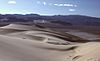
[Date]: 1983
[Location]: 37°5′45.6″N 117°40′30″W / 37.096000°N 117.67500°W / 37.096000; -117.67500
[County]: Inyo
[Ownership]: Federal (Death Valley National Park)
[Description]: The tallest dune complex in the Great Basin. -
[Name]: Fish Slough Area of Critical Environmental Concern
[Image]:
[Date]: 1975
[Location]: 37°28′8.69″N 118°24′3.1″W / 37.4690806°N 118.400861°W / 37.4690806; -118.400861
[County]: Inyo, Mono
[Ownership]: Mixed- federal (Bureau of Land Management), state, municipal
[Description]: A large, essentially undisturbed, desert wetland that provides habitat for the alkali mariposa lily and the endangered Owens pupfish. -
[Name]: Guadalupe-Nipomo Dunes
[Image]:
[Date]: 1974
[Location]: 34°57′56.13″N 120°39′1.24″W / 34.9655917°N 120.6503444°W / 34.9655917; -120.6503444
[County]: San Luis Obispo
[Ownership]: Mixed- federal (Guadalupe-Nipomo Dunes National Wildlife Refuge), state, private)
[Description]: A coastal dune tract with off-road vehicle recreation, a national wildlife refuge, beaches, and nesting for the western snowy plover. -
[Name]: Imperial Sand Hills
[Image]: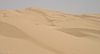
[Date]: 1966
[Location]: 32°55′0″N 115°3′0″W / 32.91667°N 115.05000°W / 32.91667; -115.05000
[County]: Imperial
[Ownership]: Federal (Bureau of Land Management)
[Description]: One of the largest dune patches in the United States. -
[Name]: Irvine Ranch Natural Landmarks
[Image]: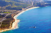
[Date]: 2006
[Location]: 33°43′53.4″N 117°41′34.8″W / 33.731500°N 117.693000°W / 33.731500; -117.693000
[County]: Orange
[Ownership]: Mixed- state, county, municipal
[Description]: A remarkably complete stratigraphic succession ranging in age from late Cretaceous to the present. -
[Name]: Lake Shasta Caverns
[Image]: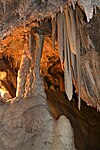
[Date]: May 2012
[Location]: 40°48′16.2″N 122°18′15.98″W / 40.804500°N 122.3044389°W / 40.804500; -122.3044389
[County]: Shasta
[Ownership]: Private
[Description]: A well-decorated Solutional cave that contains a diverse assemblage of calcite cave formations. -
[Name]: Miramar Mounds
[Image]:
[Date]: 1972
[Location]: 32°50′43″N 117°8′19″W / 32.84528°N 117.13861°W / 32.84528; -117.13861
[County]: San Diego
[Ownership]: Federal (Marine Corps Air Station Miramar)
[Description]: Contains unique soil features called mima mounds, which are found in only three or four locations in the country, and vernal pools. -
[Name]: Mitchell Caverns and Winding Stair Cave
[Image]:
[Date]: 1975
[Location]: 34°56′26.97″N 115°30′51.97″W / 34.9408250°N 115.5144361°W / 34.9408250; -115.5144361
[County]: San Bernardino
[Ownership]: State (California Department of Parks and Recreation)
[Description]: Regarded as the most important solution caverns in the Mojave Desert. -
[Name]: Mt. Diablo State Park
[Image]:
[Date]: 1982
[Location]: 37°52′37.75″N 121°55′25.79″W / 37.8771528°N 121.9238306°W / 37.8771528; -121.9238306
[County]: Contra Costa
[Ownership]: State (California Department of Parks and Recreation)
[Description]: One of the few areas in the region where geologic strata of Jurassic, Cretaceous, and Tertiary age can be seen in an aggregate thickness of 42,000 feet (13,000 m). -
[Name]: Mount Shasta
[Image]: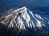
[Date]: 1976
[Location]: 41°24′35.6″N 122°11′41.52″W / 41.409889°N 122.1948667°W / 41.409889; -122.1948667
[County]: Siskiyou
[Ownership]: Federal (Shasta-Trinity National Forest)
[Description]: One of the world's largest and most impressive stratovolcanoes, within the Shasta-Trinity National Forest. -
[Name]: Pixley Vernal Pools
[Image]:
[Date]: 1987
[Location]: 35°59′3.85″N 119°12′45.04″W / 35.9844028°N 119.2125111°W / 35.9844028; -119.2125111
[County]: Tulare
[Ownership]: Private
[Description]: One of the few remaining natural vernal pools containing rare endemic plant species such as vernal pool fairy shrimp. -
[Name]: Point Lobos
[Image]:
[Date]: 1967
[Location]: 36°31′1.56″N 121°56′33.36″W / 36.5171000°N 121.9426000°W / 36.5171000; -121.9426000
[County]: Monterey
[Ownership]: State (California Department of Parks and Recreation)
[Description]: An outstanding example of terrestrial and marine environments in close association, and the only known habitat of Monterey cypress and variegated brodiaea. -
[Name]: Pygmy Forest at Jug Handle State Natural Reserve
[Image]:
[Date]: 19691973
[Location]: 39°22′29.3″N 123°47′22.15″W / 39.374806°N 123.7894861°W / 39.374806; -123.7894861
[County]: Mendocino
[Ownership]: State (California Department of Parks and Recreation)
[Description]: Includes a five step ecological staircase on which a unique forest of low, stunted trees and shrubs is located. -
[Name]: Rainbow Basin
[Image]: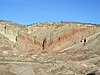
[Date]: 1966
[Location]: 35°1′46″N 117°2′12″W / 35.02944°N 117.03667°W / 35.02944; -117.03667
[County]: San Bernardino
[Ownership]: Federal (Bureau of Land Management)
[Description]: Deep erosion canyons with rugged rims with fossil evidence of insects and Miocene mammals. -
[Name]: La Brea Tar Pits (Rancho La Brea)
[Image]:
[Date]: 1964
[Location]: 34°3′46.62″N 118°21′21.49″W / 34.0629500°N 118.3559694°W / 34.0629500; -118.3559694
[County]: Los Angeles
[Ownership]: Municipal (City of Los Angeles)
[Description]: Site of the world-famous natural asphalt tar pits. -
[Name]: San Andreas Fault
[Image]: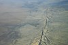
[Date]: 1965
[Location]:
[County]: San Benito
[Ownership]: Private
[Description]: One of the best illustrations of earth displacement caused by small crustal movements. -
[Name]: San Felipe Creek Area
[Image]:
[Date]: 1974
[Location]: 33°10′11″N 115°49′19″W / 33.16972°N 115.82194°W / 33.16972; -115.82194
[County]: Imperial, San Diego
[Ownership]: Federal (Bureau of Land Management), state
[Description]: A marsh containing probably the last remaining perennial natural desert stream in the Colorado Desert region. -
[Name]: Sand Ridge Wildflower Preserve
[Image]:
[Date]: 1984
[Location]: 35°18′31.26″N 118°47′24.29″W / 35.3086833°N 118.7900806°W / 35.3086833; -118.7900806
[County]: Kern
[Ownership]: Private
[Description]: A remnant natural area displaying a great diversity of floral species including the Bakersfield cactus. -
[Name]: Sharktooth Hill
[Image]:
[Date]: 1976
[Location]: 35°26′30.57″N 118°56′26.18″W / 35.4418250°N 118.9406056°W / 35.4418250; -118.9406056
[County]: Kern
[Ownership]: Private
[Description]: One of the most abundant, diverse and well- preserved fossil marine vertebrate sites in the world. -
[Name]: Tijuana River Estuary
[Image]:
[Date]: 1973
[Location]: 32°33′7.2″N 117°7′9.59″W / 32.552000°N 117.1193306°W / 32.552000; -117.1193306
[County]: San Diego
[Ownership]: Federal (Tijuana River National Estuarine Research Reserve), state, municipal
[Description]: One of the finest remaining saltwater marshes on the California coastline. -
[Name]: Torrey Pines State Reserve
[Image]:
[Date]: 1977
[Location]: 32°54′59.58″N 117°14′58.7″W / 32.9165500°N 117.249639°W / 32.9165500; -117.249639
[County]: San Diego
[Ownership]: State (California Department of Parks and Recreation)
[Description]: Contains a natural Torrey pine forest, high bluffs and sea cliffs, and endangered bird species. -
[Name]: Trona Pinnacles
[Image]:
[Date]: 1967
[Location]: 35°37′3.81″N 117°22′5.08″W / 35.6177250°N 117.3680778°W / 35.6177250; -117.3680778
[County]: San Bernardino
[Ownership]: Federal (Bureau of Land Management)
[Description]: A relict landform from the Pleistocene containing unique formations of calcium carbonate. -
[Name]: Turtle Mountain
[Image]: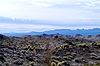
[Date]: 1973
[Location]: 34°19′5.53″N 114°51′7.28″W / 34.3182028°N 114.8520222°W / 34.3182028; -114.8520222
[County]: San Bernardino
[Ownership]: Federal (Bureau of Land Management), state
[Description]: Contains two mountain sections of entirely different composition.
New Random Display Display All Items(36)