


-
[]: 3
[Name]: Cedar Glades
[Image]: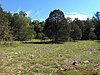
[Date]: 1973
[Location]: 36°04′25″N 86°18′41″W / 36.07366°N 86.31151°W / 36.07366; -86.31151 (Cedars of Lebanon State Park)
[County]: Wilson
[Ownership]: state (Cedars of Lebanon State Park)
[Description]: The largest and best remaining example of the cedar glade community. -
[]: 1
[Name]: Arnold Engineering Development Center Natural Areas
[Image]:
[Date]: 1974
[Location]:
[County]: Coffee
[Ownership]: federal (Arnold Air Force Base)
[Description]: Contains an extremely rare virgin swamp forest and a pristine example of an open marsh. -
[]: 8
[Name]: The Lost Sea
[Image]: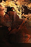
[Date]: 1974
[Location]: 35°32′08″N 84°25′52″W / 35.535556°N 84.431111°W / 35.535556; -84.431111 (Lost Sea)
[County]: Monroe
[Ownership]: private
[Description]: Cavern system that includes the largest known underground lake in the country. -
[]: 4
[Name]: Conley Hole
[Image]:
[Date]: 1973
[Location]:
[County]: Grundy
[Ownership]: private
[Description]: One of the most spectacular and outstanding examples of a pit cave in the United States. -
[]: 2
[Name]: Big Bone Cave
[Image]:
[Date]: 1973
[Location]: 35°46′21″N 85°33′25″W / 35.7726°N 85.557°W / 35.7726; -85.557 (Big Bone Cave)
[County]: Van Buren
[Ownership]: state
[Description]: Cave where giant ground sloth bones were discovered. -
[]: 5
[Name]: Cumberland Caverns
[Image]: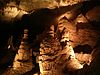
[Date]: 1973
[Location]: 35°40′09″N 85°40′51″W / 35.669167°N 85.680833°W / 35.669167; -85.680833 (Cumberland Caverns)
[County]: Warren
[Ownership]: private
[Description]: Two interconnecting caves at least 27 miles (43 km) in extent.
New Random Display Display All Items(13)