


-
[]: 4
[Name]: Gilpin's Falls
[Image]:
[Date]: 1980
[Location]:
[County]: Cecil
[Ownership]: private
[Description]: Outcrop of undeformed early Paleozoic metavolcanic pillow basalts. -
[]: 3
[Name]: Cranesville Swamp Nature Sanctuary
[Image]:
[Date]: 1964
[Location]: 39°31′53″N 79°28′55″W / 39.531389°N 79.481944°W / 39.531389; -79.481944 (Cranesville Swamp Preserve)
[County]: Garrett
[Ownership]: private (The Nature Conservancy)
[Description]: A natural bowl where cool, moist conditions yield plant and animal communities more common in northern latitudes. Extends into Preston County, West Virginia. -
[]: 1
[Name]: Battle Creek Cypress Swamp
[Image]: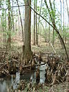
[Date]: April 1965
[Location]: Prince Frederick 38°29′25″N 76°35′27″W / 38.490275°N 76.590773°W / 38.490275; -76.590773 (Battle Creek Cyprus Swamp)
[County]: Calvert
[Ownership]: private
[Description]: One of the northernmost sites of naturally occurring bald cypress (Taxodium distichum) trees in North America, and the only large stand of the trees on the western shore of Maryland. The site also contains a wide range of plant and animal life. -
[]: 2
[Name]: Belt Woods
[Image]:
[Date]: 1974
[Location]: Woodmore 38°54′18″N 76°45′47″W / 38.90505°N 76.76304°W / 38.90505; -76.76304 (Belt Woods)
[County]: Prince George's
[Ownership]: state (Department of Natural Resources)
[Description]: One of the few remaining old-growth upland forests in the Atlantic Coastal Plain biophysiographic province. It is an example of upland hardwood forest dominated by tulip poplar and white oak. The Woods support a diverse bird population, including neotropical migrants. -
[]: 5
[Name]: Long Green Creek and Sweathouse Branch
[Image]:
[Date]: 1977
[Location]:
[County]: Baltimore
[Ownership]: state (Department of Natural Resources)
[Description]: A maturing beech-tulip poplar-white oak forest. -
[]: 6
[Name]: Sugarloaf Mountain
[Image]:
[Date]: June 1969
[Location]: Frederick 39°16′09″N 77°23′43″W / 39.269208°N 77.395248°W / 39.269208; -77.395248 (Sugarloaf Mountain)
[County]: Frederick, Montgomery
[Ownership]: private
[Description]: An outlier to the east of the main mass of the Catoctin Mountain, or a root remnant of the ancient Appalachia land mass.
New Random Display Display All Items(6)