


[Name]: Mt. Greylock Old Growth Spruce
[Image]:
[Date]: November 1987
[Location]: Adams42°38′15″N 73°09′58″W / 42.637455°N 73.166216°W / 42.637455; -73.166216 (Mt. Greylock Old Growth Spruce)
[County]: Berkshire
[Ownership]: state
[Description]: This site contains three separate stands of undisturbed old growth red spruce on the northwest slopes of Mt. Greylock, the highest mountain in Massachusetts. These stands have been undisturbed for at least 150–180 years, and may be virgin. No other old growth red spruce stands are known in southern New England, while only a few comparable or better sites occur in northern New England.[Name]: Acushnet Cedar Swamp
[Image]: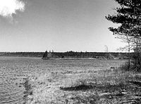
[Date]: June 1972
[Location]: New Bedford41°41′32″N 70°57′35″W / 41.692222°N 70.959722°W / 41.692222; -70.959722 (Acushnet Cedar Swamp)
[County]: Bristol
[Ownership]: state
[Description]: One of the state's largest, wildest and most impenetrable swamps, and an outstanding example of the diversity of conditions and species in the glaciated section of the oak-chestnut forest.[Name]: Poutwater Pond
[Image]:
[Date]: June 1972
[Location]: Holden42°25′29″N 71°50′18″W / 42.424722°N 71.83825°W / 42.424722; -71.83825 (Poutwater Pond)
[County]: Worcester
[Ownership]: state
[Description]: An undisturbed sphagnum-heath bog in southern New England, illustrating ecological succession from open water in a glacial depression to upland forest.[Name]: Gay Head Cliffs
[Image]:
[Date]: October 1975
[Location]: Aquinnah41°20′04″N 70°47′45″W / 41.334444°N 70.795833°W / 41.334444; -70.795833 (Gay Head Cliffs)
[County]: Dukes
[Ownership]: native lands (Wampanoag Tribe of Gay Head)
[Description]: An unusual cross section of Raritan and Magothy sediments of Cretaceous age and fossil-bearing sands of Miocene and either Pliocene or Pleistocene ages that rise as much as 150 feet (46 m) above sea level, resting on the continental shelf and detached from the mainland. The center of Wampanoag native culture.[Name]: Hawley Bog
[Image]: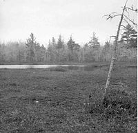
[Date]: May 1974
[Location]: Hawley42°34′33″N 72°53′26″W / 42.575807°N 72.890564°W / 42.575807; -72.890564 (Hawley Bog)
[County]: Franklin
[Ownership]: private
[Description]: Unspoiled cold northern boreal sphagnum-heath bog occupying an old shallow glacial lake basin which demonstrates bog succession from the central open water pond to the surrounding spruce-fir forest.[Name]: Bartholomew's Cobble
[Image]:
[Date]: October 1971
[Location]: Ashley Falls42°03′26″N 73°21′03″W / 42.057222°N 73.350833°W / 42.057222; -73.350833 (Bartholomew's Cobble)
[County]: Berkshire
[Ownership]: private (The Trustees of Reservations)
[Description]: Contains over 800 plant species, including North America's greatest diversity of ferns.
New Random Display Display All Items(11)