


-
[]: 12
[Name]: Little Blanco River Bluff
[Image]:
[Date]: 1982
[Location]:
[County]: Blanco
[Ownership]: private
[Description]: An unspoiled example of the limestone bluff communities of the Edwards Plateau. -
[]: 13
[Name]: Longhorn Cavern
[Image]: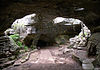
[Date]: 1971
[Location]: 30°41′04″N 98°21′03″W / 30.684441°N 98.350970°W / 30.684441; -98.350970 (Longhorn Cavern)
[County]: Burnet
[Ownership]: state/Texas Department of Parks and Wildlife
[Description]: State park contains an outstanding example of cave features formed during the phreatic phase of development. -
[]: 17
[Name]: Palo Duro Canyon State Park
[Image]: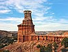
[Date]: 1976
[Location]: 34°59′05″N 101°42′07″W / 34.984709°N 101.701867°W / 34.984709; -101.701867 (Palo Duro Canyon State Park)
[County]: Armstrong, Randall
[Ownership]: state/Texas Department of Parks and Wildlife
[Description]: Spectacular canyon that is an excellent example of a landform created by running water. -
[]: 11
[Name]: High Plains Natural Area
[Image]:
[Date]: 1980
[Location]: 34°55′10″N 102°06′40″W / 34.919517°N 102.111118°W / 34.919517; -102.111118 (High Plains Natural Area)
[County]: Randall
[Ownership]: federal/US Fish & Wildlife Service
[Description]: One of the best developed, least disturbed natural shortgrass climax communities remaining in the Great Plains. Part of Buffalo Lake National Wildlife Refuge. -
[]: 5
[Name]: Devil's Sinkhole
[Image]:
[Date]: 1972
[Location]: 30°00′57″N 100°12′31″W / 30.015773°N 100.208552°W / 30.015773; -100.208552 (Devil's Sinkhole)
[County]: Edwards
[Ownership]: state/Texas Department of Parks and Wildlife
[Description]: A deep, bell-shaped, collapsed limestone sink. -
[]: 8
[Name]: Enchanted Rock
[Image]: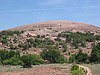
[Date]: 1971
[Location]: 30°29′46″N 98°49′12″W / 30.496033°N 98.819952°W / 30.496033; -98.819952 (Enchanted Rock)
[County]: Gillespie, Llano
[Ownership]: state/Texas Department of Parks and Wildlife
[Description]: A classic illustration of a batholith and of the exfoliation process.
New Random Display Display All Items(20)