


-
[]: 5
[Name]: Great Rift of Idaho
[Image]:
[Date]: 1968
[Location]: Craters of the Moon National Monument and Preserve43°27′42″N 113°33′46″W / 43.46167°N 113.56278°W / 43.46167; -113.56278 (Great Rift)
[County]: Blaine, Minidoka, Power
[Ownership]: federal (Craters of the Moon National Monument and Preserve)
[Description]: A tensional fracture in the Earth's crust. -
[]: 6
[Name]: Hagerman Fauna Sites
[Image]:
[Date]: 1975
[Location]: Hagerman Fossil Beds National Monument42°47′26″N 114°56′41″W / 42.7906°N 114.9448°W / 42.7906; -114.9448 (Hagerman Fossil Beds)
[County]: Twin Falls
[Ownership]: federal (Hagerman Fossil Beds National Monument)
[Description]: Contains the world's richest deposits of Upper Pliocene age terrestrial fossils. -
[]: 9
[Name]: Menan Buttes
[Image]:
[Date]: 1980
[Location]: Menan43°36′N 111°30′W / 43.6°N 111.5°W / 43.6; -111.5 (Menan Buttes)
[County]: Jefferson, Madison
[Ownership]: federal (Bureau of Land Management)
[Description]: Contains outstanding examples of glass tuff cones, which are found in only a few places in the world. -
[]: 7
[Name]: Hell's Half Acre Lava Field
[Image]:
[Date]: 1976
[Location]: Blackfoot43°30′N 112°27′W / 43.5°N 112.45°W / 43.5; -112.45 (Hell's Half Acre Lava Field)
[County]: Bingham, Bonneville
[Ownership]: federal (Bureau of Land Management)
[Description]: Fully exposed pahoehoe lava flow. -
[]: 3
[Name]: Cassia Silent City of Rocks
[Image]: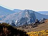
[Date]: 1974
[Location]: Malta42°04′34″N 113°42′06″W / 42.076026°N 113.701676°W / 42.076026; -113.701676 (City of Rocks)
[County]: Cassia
[Ownership]: federal (City of Rocks National Reserve)
[Description]: Monolithic landforms created by exfoliation processes on exposed massive granite plutons. -
[]: 11
[Name]: Sheep Rock
[Image]:
[Date]: 1976
[Location]: Council45°11′30″N 116°40′17″W / 45.191651°N 116.67132°W / 45.191651; -116.67132 (Sheep Rock)
[County]: Adams
[Ownership]: federal (Payette National Forest)
[Description]: Horizontally layered lavas that represent successive flows on the Columbia River Basalt Plateau.
New Random Display Display All Items(11)