


-
[]: 1
[Name]: Ancient River Warren Channel
[Image]:
[Date]: 1965
[Location]:
[County]: Grant
[Ownership]: mixed- state, private
[Description]: A channel cut by the Ancient River Warren during the Ice Age. -
[]: 2
[Name]: Bear Butte
[Image]:
[Date]: 1965
[Location]: 44°28′33″N 103°25′37″W / 44.475833°N 103.426944°W / 44.475833; -103.426944 (Bear Butte)
[County]: Meade
[Ownership]: mixed- state, tribal, private
[Description]: A cone-shaped mass of igneous rock standing alone 1,300 feet (400 m) above the surrounding plains. -
[]: 3
[Name]: Bijou Hills
[Image]:
[Date]: 1976
[Location]: 43°31′04″N 99°08′50″W / 43.517778°N 99.147222°W / 43.517778; -99.147222 (Bijou Hills)
[County]: Charles Mix
[Ownership]: private
[Description]: An excellent example of an erosional remnant of soft clays and shales capped by a channel sandstone and quartzite. -
[]: 4
[Name]: Buffalo Slough
[Image]:
[Date]: 1980
[Location]: 43°52′28″N 96°56′20″W / 43.874308°N 96.939013°W / 43.874308; -96.939013 (Buffalo Slough)
[County]: Lake
[Ownership]: state
[Description]: Excellent examples of a prairie pothole with native emergent vegetation, and a native bluestem prairie. -
[]: 5
[Name]: The Castles
[Image]:
[Date]: 1976
[Location]: 45°31′39″N 103°10′15″W / 45.527583°N 103.170965°W / 45.527583; -103.170965 (The Castles)
[County]: Harding
[Ownership]: federal (Custer National Forest)
[Description]: Steep-walled, flat-topped buttes standing 200 to 400 feet (61 to 122 m) above the surrounding prairie. -
[]: 6
[Name]: Cathedral Spires and Limber Pine Natural Area
[Image]: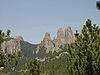
[Date]: 1976
[Location]: 43°50′28″N 103°32′40″W / 43.841111°N 103.544444°W / 43.841111; -103.544444 (Cathedral Spires and Limber Pine Natural Area)
[County]: Custer
[Ownership]: state (Custer State Park)
[Description]: An excellent, rare example of joint-controlled weathering of granite. -
[]: 7
[Name]: Cottonwood Slough- Dry Run
[Image]:
[Date]: 1975
[Location]: 44°57′25″N 97°11′37″W / 44.957077°N 97.193497°W / 44.957077; -97.193497 (Cottonwood Slough- Dry Run)
[County]: Roberts
[Ownership]: mixed- state, private
[Description]: A completely undisturbed wetland complex including potholes, streams, shallow open water, lakes, and marsh. -
[]: 8
[Name]: Fort Randall Eagle Roost
[Image]:
[Date]: 1967
[Location]:
[County]: Gregory
[Ownership]: federal (Missouri National Recreational River)
[Description]: A prime winter roosting area for bald and golden eagles. -
[]: 9
[Name]: Lake Thompson
[Image]:
[Date]: 1975
[Location]: 44°17′06″N 97°27′43″W / 44.285°N 97.461944°W / 44.285; -97.461944 (Lake Thompson)
[County]: Kingsbury
[Ownership]: state
[Description]: Contains a large undisturbed and unmanipulated marsh, an outstanding waterfowl breeding and resting area. -
[]: 10
[Name]: Mammoth Site of Hot Springs
[Image]:
[Date]: 1980
[Location]: 43°25′29″N 103°28′59″W / 43.42471°N 103.48313°W / 43.42471; -103.48313 (Mammoth Site of Hot Springs)
[County]: Fall River
[Ownership]: private
[Description]: One of the largest concentrations of mammoth remains in the United States. -
[]: 11
[Name]: Red Lake
[Image]:
[Date]: 1975
[Location]: 43°43′35″N 99°13′31″W / 43.726352°N 99.22518°W / 43.726352; -99.22518 (Red Lake)
[County]: Brule
[Ownership]: state
[Description]: One of the largest remaining natural and unmanipulated prairie pothole lakes. -
[]: 12
[Name]: Sica Hollow
[Image]:
[Date]: 1967
[Location]: 45°44′31″N 97°14′33″W / 45.741944°N 97.2425°W / 45.741944; -97.2425 (Sica Hollow)
[County]: Marshall
[Ownership]: state
[Description]: Displays many facets of natural history. -
[]: 13
[Name]: Snake Butte
[Image]:
[Date]: 1967
[Location]:
[County]: Jackson
[Ownership]: tribal (Oglala Sioux)
[Description]: Illustrates one of two types of sand calcite deposits in the world.
New Random Display Display All Items(13)