


-
[]: 4
[Name]: Red Canyon
[Image]:
[Date]: November 1980
[Location]: Lander42°40′20″N 108°39′29″W / 42.672087°N 108.658175°W / 42.672087; -108.658175
[County]: Fremont
[Ownership]: federal, state, private
[Description]: A canyon exposing a number of sedimentary formations as well as 10,000 years of human habitation. -
[]: 2
[Name]: Como Bluff
[Image]: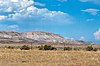
[Date]: May 1966, November 1973
[Location]: Rock River41°52′53″N 106°04′34″W / 41.881384°N 106.076217°W / 41.881384; -106.076217
[County]: Albany
[Ownership]: federal, state, private
[Description]: A ridge noted for multiple significant fossil discoveries from the late Jurassic of the Mesozoic Era. -
[]: 5
[Name]: Sand Creek
[Image]:
[Date]: December 1984
[Location]: 40°59′49″N 105°46′14″W / 40.99694°N 105.77056°W / 40.99694; -105.77056 (Sand Creek)
[County]: Albany
[Ownership]: federal, state, private
[Description]: The most spectacular examples of cross-bedded sandstone and "topple blocks" in North America. NNL area extends across Colorado border. -
[]: 3
[Name]: Crooked Creek Natural Area
[Image]:
[Date]: 1966
[Location]:
[County]: Big Horn
[Ownership]: federal (Bighorn National Forest)
[Description]: A rich source of fossils of Early Cretaceous land vertebrates. -
[]: 1
[Name]: The Big Hollow
[Image]:
[Date]: November 1980
[Location]: Laramie41°18′48″N 105°43′17″W / 41.313209°N 105.721307°W / 41.313209; -105.721307
[County]: Albany
[Ownership]: federal, private
[Description]: A large wind eroded deflection basin. -
[]: 6
[Name]: Two Ocean Pass
[Image]:
[Date]: October 1965
[Location]: Teton Wilderness44°02′35″N 110°10′30″W / 44.04293°N 110.17495°W / 44.04293; -110.17495
[County]: Teton
[Ownership]: federal (Bridger-Teton National Forest)
[Description]: A pass located on the continental divide. Here, at a place called Parting of the Waters, North Two Ocean Creek splits into its two distributaries which form the headwaters of Pacific Creek and Atlantic Creek. Waters from these two creeks ultimately flow the Pacific and Atlantic ocean drainages, respectively.
New Random Display Display All Items(6)