


-
[]: 11
[Name]: Zumwalt Prairie
[Image]: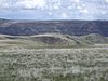
[Date]: 2013
[Location]: 45°32′N 117°05′W / 45.54°N 117.09°W / 45.54; -117.09 (Zumwalt Prairie)
[County]: Wallowa
[Ownership]: private
[Description]: Largest contiguous remaining tract of bunchgrass prairie in the nation. -
[]: 8
[Name]: Mount Howard-East Peak
[Image]:
[Date]: 2016
[Location]: 45°15′40″N 117°10′44″W / 45.260987°N 117.178778°W / 45.260987; -117.178778 (Mount Howard-East Peak)
[County]: Wallowa
[Ownership]: federal
[Description]: Contains botanically diverse montane grassland habitats and populations of endemic and rare plant species. -
[]: 7
[Name]: Newberry Crater
[Image]: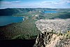
[Date]: 1976
[Location]: 43°41′21″N 121°15′18″W / 43.689194°N 121.254889°W / 43.689194; -121.254889 (Newberry Volcano)
[County]: Deschutes
[Ownership]: federal
[Description]: Atypical shield volcano in Deschutes National Forest. -
[]: 5
[Name]: The Island
[Image]: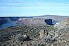
[Date]: 2011
[Location]: 44°33′31″N 121°16′38″W / 44.558489°N 121.277143°W / 44.558489; -121.277143 (The Island)
[County]: Jefferson
[Ownership]: federal
[Description]: Native juniper savanna on an isolated plateau at the confluence of the Deschutes and Crooked Rivers. Part of Ochoco National Forest. -
[]: 1
[Name]: Crown Point
[Image]: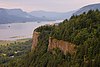
[Date]: 1971
[Location]: 45°32′22″N 122°14′39″W / 45.5395°N 122.24422°W / 45.5395; -122.24422 (Crown Point)
[County]: Multnomah
[Ownership]: state park
[Description]: Promontory in Columbia Gorge -
[]: 6
[Name]: Lawrence Memorial Grassland Preserve
[Image]:
[Date]: 1984
[Location]: 44°57′03″N 120°47′56″W / 44.950889°N 120.7988834°W / 44.950889; -120.7988834 (Lawrence Memorial Grassland Preserve)
[County]: Oregon
[Ownership]: private
[Description]: An excellent illustration of "biscuit and scabland" topography.
New Random Display Display All Items(11)