


-
[]: 1
[Name]: East Inlet Natural Area
[Image]:
[Date]: 1972
[Location]: 45°12′41″N 71°06′38″W / 45.211385°N 71.110497°W / 45.211385; -71.110497 (East Inlet Natural Area)
[County]: Coos
[Ownership]: Private
[Description]: Contains a black spruce-tamarack bog and a virgin, balsam fir-red spruce forest. -
[]: 2
[Name]: Floating Island
[Image]:
[Date]: 1972
[Location]:
[County]: Coos
[Ownership]: Federal
[Description]: A floating heath bog in Umbagog National Wildlife Refuge. -
[]: 3
[Name]: Franconia Notch
[Image]: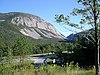
[Date]: 1971
[Location]: Franconia 44°10′15″N 71°41′17″W / 44.1707°N 71.6881°W / 44.1707; -71.6881
[County]: Grafton
[Ownership]: State
[Description]: An old stream valley, ground to a U-shape by glacial movement. -
[]: 4
[Name]: Heath Pond Bog
[Image]:
[Date]: 1972
[Location]: 43°45′34″N 71°06′59″W / 43.759423°N 71.116465°W / 43.759423; -71.116465 (Heath Pond Bog)
[County]: Carroll
[Ownership]: State
[Description]: A classic example of bog succession from open water to sphagnum-heath-black spruce bog. -
[]: 5
[Name]: Madison Boulder Natural Area
[Image]:
[Date]: 1970
[Location]: 43°56′00″N 71°09′46″W / 43.93329°N 71.162671°W / 43.93329; -71.162671 (Madison Boulder Natural Area)
[County]: Carroll
[Ownership]: State
[Description]: The largest known glacial erratic in North America. -
[]: 6
[Name]: Mount Monadnock
[Image]:
[Date]: 1987
[Location]: 42°51′39″N 72°06′29″W / 42.860833°N 72.108056°W / 42.860833; -72.108056 (Mount Monadnock)
[County]: Cheshire
[Ownership]: Mixed- state, municipal, private
[Description]: A prominent, isolated, relict mountain. Type locality of a monadnock. -
[]: 7
[Name]: Nancy Brook Virgin Spruce Forest and Scenic Area
[Image]:
[Date]: 1987
[Location]:
[County]: Carroll, Grafton
[Ownership]: Federal
[Description]: May be the largest virgin forest tract in the northeastern United States. A part of White Mountain National Forest. -
[]: 8
[Name]: Pondicherry Wildlife Refuge
[Image]:
[Date]: 1972
[Location]: 44°22′40″N 71°31′33″W / 44.377846°N 71.525937°W / 44.377846; -71.525937 (Pondicherry Wildlife Refuge)
[County]: Coos
[Ownership]: State
[Description]: Two shallow, warm water ponds, surrounded by marsh, bog and forest that support a great variety of birds. -
[]: 9
[Name]: Rhododendron Natural Area
[Image]:
[Date]: 1982
[Location]: Fitzwilliam 42°46′49″N 72°11′20″W / 42.7804°N 72.1889°W / 42.7804; -72.1889
[County]: Cheshire
[Ownership]: State
[Description]: The largest, thriving stand of rhododendron in central and southern New England. -
[]: 10
[Name]: Spruce Hole Bog
[Image]: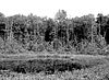
[Date]: 1972
[Location]: 43°07′34″N 70°58′04″W / 43.126111°N 70.967778°W / 43.126111; -70.967778 (Spruce Hole Bog)
[County]: Strafford
[Ownership]: Municipal
[Description]: The last known kettle hole bog in southern New Hampshire. -
[]: 11
[Name]: White Lake Pitch Pine
[Image]:
[Date]: 1980
[Location]: 43°50′09″N 71°12′32″W / 43.8359°N 71.2089°W / 43.8359; -71.2089 (White Lake Pitch Pine)
[County]: Carroll
[Ownership]: State
[Description]: A mature, undisturbed pitch pine and bear-oak forest.
New Random Display Display All Items(11)