


-
[]: 2
[Name]: Beckley Bog
[Image]:
[Date]: May 1977
[Location]: Norfolk 41°58′08″N 73°09′44″W / 41.96889°N 73.16222°W / 41.96889; -73.16222 (Beckley Bog)
[County]: Litchfield
[Ownership]: private
[Description]: The southernmost Sphagnum-heath-black spruce bog in New England. Purchased by the Nature Conservancy in 1956. -
[]: 8
[Name]: Pachaug-Great Meadow Swamp
[Image]:
[Date]: May 1973
[Location]: Voluntown 41°35′57″N 71°52′41″W / 41.599167°N 71.878056°W / 41.599167; -71.878056 (Pachaug-Great Meadow Swamp)
[County]: New London
[Ownership]: mixed- state, private
[Description]: Known for the Atlantic white cedar swamp inside the Pachaug State Forest. Includes sections of the Pachaug River and the Great Meadow Brook. -
[]: 6
[Name]: Dinosaur Trackway
[Image]: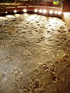
[Date]: April 1968
[Location]: Rocky Hill 41°39′07″N 72°39′25″W / 41.651944°N 72.656944°W / 41.651944; -72.656944 (Dinosaur Trackway)
[County]: Hartford
[Ownership]: state
[Description]: One of the largest dinosaur track sites in North America, with a fine display of early Jurassic fossil tracks in sandstone from about 200 million years ago. -
[]: 1
[Name]: Bartholomew's Cobble
[Image]:
[Date]: October 1971
[Location]: Canaan 42°03′26″N 73°21′03″W / 42.057222°N 73.350833°W / 42.057222; -73.350833 (Bartholomew's Cobble)
[County]: Litchfield
[Ownership]: private
[Description]: Open space preserve, agricultural preserve, and bio-reserve primarily located in Ashley Falls, Massachusetts and edging into Canaan, Connecticut. The preserve contains over 800 plant species including North America's greatest diversity of ferns. It is open to the public with hiking trails and a visitors center. -
[]: 7
[Name]: McLean Game Refuge Natural Areas
[Image]: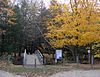
[Date]: November 1973
[Location]: Granby 41°55′14″N 72°47′19″W / 41.920545°N 72.788544°W / 41.920545; -72.788544 (McLean Game Refuge Natural Areas)
[County]: Hartford
[Ownership]: state
[Description]: 4,400 acres (1,800 ha) forest in multiple tracts has a very diverse group of species as well as evidence of glacial activity. -
[]: 5
[Name]: Chester Cedar Swamp
[Image]:
[Date]: May 1973
[Location]: Chester 41°23′15″N 72°29′20″W / 41.387499°N 72.488995°W / 41.387499; -72.488995 (Chester Cedar Swamp)
[County]: Middlesex
[Ownership]: mixed- state, municipal
[Description]: Known for its Atlantic white cedar swamp within the Cockaponset State Forest.
New Random Display Display All Items(8)