


-
[]: 1
[Name]: Bridger Fossil Area
[Image]:
[Date]: 1973
[Location]:
[County]: Carbon
[Ownership]: federal (Bureau of Land Management)
[Description]: Contains fossils of Deinonychus antirrhopus. -
[]: 2
[Name]: Bug Creek Fossil Area
[Image]:
[Date]: 1966
[Location]: 47°40′59″N 106°13′09″W / 47.68299°N 106.219193°W / 47.68299; -106.219193 (Bug Creek Fossil Area)
[County]: McCone
[Ownership]: federal (Charles M. Russell National Wildlife Refuge)
[Description]: Produced abundant remains of small, Cretaceous mammals. -
[]: 3
[Name]: Capitol Rock
[Image]:
[Date]: 1976
[Location]: 45°35′45″N 104°07′12″W / 45.59584°N 104.120134°W / 45.59584; -104.120134 (Capitol Rock)
[County]: Carter
[Ownership]: federal (Custer National Forest)
[Description]: A remnant of the once continuous blanket of Tertiary deposits that covered much of the Great Plains. -
[]: 4
[Name]: Cloverly Formation Site
[Image]: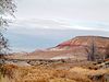
[Date]: 1973
[Location]:
[County]: Big Horn
[Ownership]: tribal land (Crow Nation)
[Description]: Contains early Cretaceous vertebrate fossils. -
[]: 5
[Name]: Glacial Lake Missoula
[Image]:
[Date]: 1966
[Location]: 46°56′20″N 114°08′37″W / 46.938889°N 114.143611°W / 46.938889; -114.143611 (Lake Missoula)
[County]: Sanders
[Ownership]: private
[Description]: Contains the best examples of giant flood ripples in the North American continent. -
[]: 6
[Name]: Hell Creek Fossil Area
[Image]: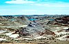
[Date]: 1966
[Location]: 46°09′N 107°29′W / 46.15°N 107.48°W / 46.15; -107.48 (Hell Creek Fossil Area)
[County]: Several
[Ownership]: mixed- state, private
[Description]: The type locality for Tyrannosaurus rex, Ankylosaurus magniventris, and Brachychampsa fontana fossils. -
[]: 7
[Name]: Medicine Lake Site
[Image]:
[Date]: 1980
[Location]: 48°28′05″N 104°22′54″W / 48.468056°N 104.381667°W / 48.468056; -104.381667 (Medicine Lake National Wildlife Refuge)
[County]: Sheridan
[Ownership]: federal (Medicine Lake National Wildlife Refuge)
[Description]: An exceptional example of the processes of continental glaciation, including till, outwash, eskers, kames, and terrace deposits. -
[]: 8
[Name]: Middle Fork Canyon
[Image]:
[Date]: 1977
[Location]: 46°07′54″N 111°06′35″W / 46.131701°N 111.109849°W / 46.131701; -111.109849 (Middle Fork Canyon)
[County]: Gallatin
[Ownership]: federal (Bureau of Land Management)
[Description]: An outstanding example of a canyon cut across the grain of the geologic structure by a superposed stream. -
[]: 9
[Name]: Red Rock Lakes National Wildlife Refuge
[Image]: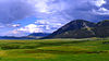
[Date]: 1966
[Location]: 44°37′49″N 111°46′53″W / 44.630278°N 111.781389°W / 44.630278; -111.781389 (Red Rock Lakes National Wildlife Refuge)
[County]: Beaverhead
[Ownership]: federal
[Description]: A series of relatively undisturbed, high-altitude ecosystem types representative of pre-European settlement conditions. -
[]: 10
[Name]: Square Butte (mountain)
[Image]: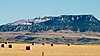
[Date]: 1980
[Location]: 47°28′35″N 110°14′31″W / 47.476499°N 110.241999°W / 47.476499; -110.241999 (Square Butte (mountain))
[County]: Chouteau
[Ownership]: federal (Bureau of Land Management)
[Description]: One of the best examples of banded magmatic rock in the United States.
New Random Display Display All Items(10)