


-
[]: 1
[Name]: Butler Cave- Breathing Cave
[Image]:
[Date]: 1973
[Location]:
[County]: Bath
[Ownership]: Private
[Description]: Two major cave systems that contain a 40-foot (12 m) waterfall, a natural bridge, unusually fine crystalline formations, and an underground lake. Access is managed by the Butler Cave Conservation Society. -
[]: 2
[Name]: Caledon Natural Area
[Image]:
[Date]: 1974
[Location]: 38°21′09″N 77°07′58″W / 38.3525°N 77.132778°W / 38.3525; -77.132778 (Caledon State Park)
[County]: King George
[Ownership]: State (state park)
[Description]: One of the best examples of oak-tulip poplar-dominated virgin upland forest in the country. -
[]: 3
[Name]: Charles C. Steirly Natural Area
[Image]:
[Date]: 1974
[Location]: 37°03′03″N 76°58′52″W / 37.050833°N 76.981111°W / 37.050833; -76.981111 (Charles C. Steirly Natural Area)
[County]: Sussex
[Ownership]: State (Natural Area Preserve)
[Description]: A small, essentially virgin stand of climax bald cypress-water tupelo swamp forest. -
[]: 4
[Name]: Grand Caverns
[Image]: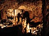
[Date]: 1973
[Location]: 38°15′37″N 78°50′07″W / 38.260278°N 78.835278°W / 38.260278; -78.835278 (Grand Caverns)
[County]: Augusta
[Ownership]: Municipal
[Description]: Contains unique shield formations as well as draperies, flowstone, stalactites and stalagmites. -
[]: 5
[Name]: Great Dismal Swamp
[Image]:
[Date]: 1972
[Location]: 36°38′27″N 76°27′06″W / 36.640876°N 76.451797°W / 36.640876; -76.451797 (Great Dismal Swamp)
[County]: Suffolk City
[Ownership]: Federal (National Wildlife Refuge)
[Description]: A remnant of the original Great Dismal Swamp. -
[]: 6
[Name]: Luray Caverns
[Image]:
[Date]: 1973
[Location]: 38°39′52″N 78°29′02″W / 38.664306°N 78.483806°W / 38.664306; -78.483806 (Luray Caverns)
[County]: Page
[Ownership]: Private
[Description]: A cave ornately decorated with cascades, columns, stalactites, stalagmites and pools. -
[]: 7
[Name]: Montpelier Forest
[Image]:
[Date]: 1987
[Location]: 38°13′11″N 78°10′10″W / 38.219722°N 78.169444°W / 38.219722; -78.169444 (Montpelier Forest)
[County]: Orange
[Ownership]: Private
[Description]: A mature forest dominated primarily by tulip poplar and spicebush, located on the grounds of President James Madison's Montpelier estate. -
[]: 8
[Name]: Rich Hole
[Image]:
[Date]: 1974
[Location]: 37°52′17″N 79°38′18″W / 37.871389°N 79.638333°W / 37.871389; -79.638333 (Rich Hole)
[County]: Rockbridge
[Ownership]: Federal (George Washington National Forest)
[Description]: An outstanding example of a "cove" hardwood forest. -
[]: 9
[Name]: Seashore Natural Area
[Image]:
[Date]: 1965
[Location]: 36°54′22″N 76°00′55″W / 36.906111°N 76.015278°W / 36.906111; -76.015278 (Seashore Natural Area)
[County]: Virginia Beach
[Ownership]: State (state park)
[Description]: Contains parallel dunes that are densely wooded with two distinct forest types of semitropical character. -
[]: 10
[Name]: Virginia Coast Reserve
[Image]:
[Date]: 1979
[Location]: 37°24′59″N 75°41′20″W / 37.4163°N 75.689°W / 37.4163; -75.689 (Virginia Coast Reserve)
[County]: Accomack, Northampton
[Ownership]: Private
[Description]: Relatively undisturbed barrier island-lagoon complex. A refuge for migratory shorebirds, waterfowl and colonial nesting birds.
New Random Display Display All Items(10)