


-
[]: 1
[Name]: Attwater Prairie Chicken Preserve
[Image]: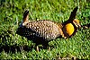
[Date]: 1968
[Location]: 29°40′08″N 96°16′00″W / 29.668827°N 96.266751°W / 29.668827; -96.266751 (Attwater Prairie Chicken Preserve)
[County]: Colorado
[Ownership]: federal/US Fish & Wildlife Service
[Description]: Contains the only significant segment of gulf coastal prairie. -
[]: 2
[Name]: Bayside Resaca Area
[Image]:
[Date]: 1980
[Location]: 26°13′45″N 97°20′50″W / 26.229081°N 97.347231°W / 26.229081; -97.347231 (Bayside Resaca Area)
[County]: Cameron
[Ownership]: federal/US Fish & Wildlife Service
[Description]: Located in Laguna Atascosa National Wildlife Refuge, contains an excellent example of a resaca. -
[]: 3
[Name]: Catfish Creek
[Image]:
[Date]: 1983
[Location]: 31°54′27″N 95°54′09″W / 31.90750°N 95.90250°W / 31.90750; -95.90250 (Catfish Creek)
[County]: Anderson
[Ownership]: state/Texas Department of Parks and Wildlife
[Description]: One of the few remaining undisturbed riparian habitats in the western Gulf Coastal Plain -
[]: 4
[Name]: Caverns of Sonora
[Image]:
[Date]: 1965
[Location]: 30°33′18″N 100°48′44″W / 30.55500°N 100.81222°W / 30.55500; -100.81222 (Caverns of Sonora)
[County]: Sutton
[Ownership]: private
[Description]: Contains unusual formations, such as bladed helictites and coralloid growths -
[]: 5
[Name]: Devil's Sinkhole
[Image]:
[Date]: 1972
[Location]: 30°00′57″N 100°12′31″W / 30.015773°N 100.208552°W / 30.015773; -100.208552 (Devil's Sinkhole)
[County]: Edwards
[Ownership]: state/Texas Department of Parks and Wildlife
[Description]: A deep, bell-shaped, collapsed limestone sink. -
[]: 6
[Name]: Dinosaur Valley State Park
[Image]:
[Date]: 1968
[Location]: 32°14′46″N 97°48′48″W / 32.246194°N 97.813375°W / 32.246194; -97.813375 (Dinosaur Valley State Park)
[County]: Somervell
[Ownership]: state/Texas Department of Parks and Wildlife
[Description]: The only known source of distinct and full-grown sauropod footprints. -
[]: 7
[Name]: Ezell's Cave
[Image]:
[Date]: 1971
[Location]:
[County]: Hays
[Ownership]: private
[Description]: Houses at least 36 species of cave fauna. -
[]: 8
[Name]: Enchanted Rock
[Image]: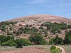
[Date]: 1971
[Location]: 30°29′46″N 98°49′12″W / 30.496033°N 98.819952°W / 30.496033; -98.819952 (Enchanted Rock)
[County]: Gillespie, Llano
[Ownership]: state/Texas Department of Parks and Wildlife
[Description]: A classic illustration of a batholith and of the exfoliation process. -
[]: 9
[Name]: Fort Worth Nature Center and Refuge
[Image]:
[Date]: 1980
[Location]: 32°50′36″N 97°28′38″W / 32.843450°N 97.477225°W / 32.843450; -97.477225 (Fort Worth Nature Center and Refuge)
[County]: Tarrant
[Ownership]: municipal/City of Fort Worth
[Description]: Contains outstanding examples of the unique oak-hickory forest associations called cross timbers. -
[]: 10
[Name]: Greenwood Canyon
[Image]:
[Date]: 1975
[Location]:
[County]: Montague
[Ownership]: private
[Description]: A rich source of early Cretaceous mammalian fossils. -
[]: 11
[Name]: High Plains Natural Area
[Image]:
[Date]: 1980
[Location]: 34°55′10″N 102°06′40″W / 34.919517°N 102.111118°W / 34.919517; -102.111118 (High Plains Natural Area)
[County]: Randall
[Ownership]: federal/US Fish & Wildlife Service
[Description]: One of the best developed, least disturbed natural shortgrass climax communities remaining in the Great Plains. Part of Buffalo Lake National Wildlife Refuge. -
[]: 12
[Name]: Little Blanco River Bluff
[Image]:
[Date]: 1982
[Location]:
[County]: Blanco
[Ownership]: private
[Description]: An unspoiled example of the limestone bluff communities of the Edwards Plateau. -
[]: 13
[Name]: Longhorn Cavern
[Image]: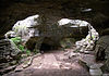
[Date]: 1971
[Location]: 30°41′04″N 98°21′03″W / 30.684441°N 98.350970°W / 30.684441; -98.350970 (Longhorn Cavern)
[County]: Burnet
[Ownership]: state/Texas Department of Parks and Wildlife
[Description]: State park contains an outstanding example of cave features formed during the phreatic phase of development. -
[]: 14
[Name]: Lost Maples State Natural Area
[Image]:
[Date]: 1980
[Location]: 29°48′28″N 99°34′15″W / 29.807719°N 99.570697°W / 29.807719; -99.570697 (Lost Maples State Natural Area)
[County]: Bandera, Real
[Ownership]: state/Texas Department of Parks and Wildlife
[Description]: An excellent illustration of Edwards Plateau flora and fauna. -
[]: 15
[Name]: Muleshoe National Wildlife Refuge
[Image]:
[Date]: 1980
[Location]: 33°57′19″N 102°46′37″W / 33.955295°N 102.776973°W / 33.955295; -102.776973 (Muleshoe National Wildlife Refuge)
[County]: Bailey
[Ownership]: federal/US Fish & Wildlife Service
[Description]: Saline lake beds, and shortgrass grama grasslands characteristic of the high plains. -
[]: 16
[Name]: Odessa Meteor Crater
[Image]: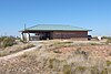
[Date]: 1965
[Location]: 31°45′25″N 102°28′45″W / 31.756998°N 102.479125°W / 31.756998; -102.479125 (Odessa Meteor Crater)
[County]: Ector
[Ownership]: county
[Description]: Contains two meteorite impact craters. The largest is 550 feet (170 m) in diameter. -
[]: 17
[Name]: Palo Duro Canyon State Park
[Image]: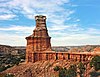
[Date]: 1976
[Location]: 34°59′05″N 101°42′07″W / 34.984709°N 101.701867°W / 34.984709; -101.701867 (Palo Duro Canyon State Park)
[County]: Armstrong, Randall
[Ownership]: state/Texas Department of Parks and Wildlife
[Description]: Spectacular canyon that is an excellent example of a landform created by running water. -
[]: 18
[Name]: Santa Ana National Wildlife Refuge
[Image]:
[Date]: 1966
[Location]: 26°05′07″N 98°08′04″W / 26.08522°N 98.13448°W / 26.08522; -98.13448 (Santa Ana National Wildlife Refuge)
[County]: Hidalgo
[Ownership]: federal/US Fish & Wildlife Service
[Description]: A living museum of the lowland forested area of the Lower Rio Grande Valley. -
[]: 19
[Name]: Natural Bridge Caverns
[Image]: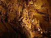
[Date]: 1971
[Location]: 29°41′32″N 98°20′34″W / 29.692351°N 98.342760°W / 29.692351; -98.342760 (Natural Bridge Caverns)
[County]: Comal
[Ownership]: private
[Description]: A multilevel cavern system containing unusual speleothems and intricate helictites. -
[]: 20
[Name]: Cave Without a Name
[Image]:
[Date]: 2009
[Location]: 29°52′45″N 98°38′31″W / 29.8791769°N 98.6419260°W / 29.8791769; -98.6419260 (Cave Without a Name)
[County]: Kendall
[Ownership]: private
[Description]: Contains rare and nationally outstanding examples of speleothems.
New Random Display Display All Items(20)