


-
[]: 1
[Name]: Big Hammock Natural Area
[Image]:
[Date]: 1976
[Location]:
[County]: Tattnall
[Ownership]: state (Dept. of Natural Resources)
[Description]: Relatively undisturbed broadleaf evergreen hammock forest. -
[]: 2
[Name]: Camp E.F. Boyd Natural Area
[Image]:
[Date]: 1974
[Location]:
[County]: Emanuel
[Ownership]: private
[Description]: One of the best representatives of the upland sand ridge ecosystem of the Coastal Plain -
[]: 3
[Name]: Cason J. Calloway Memorial Forest
[Image]:
[Date]: 1972
[Location]:
[County]: Harris
[Ownership]: private
[Description]: An outstanding example of transitional conditions between eastern deciduous and southern coniferous forest types. -
[]: 4
[Name]: Ebenezer Creek Swamp
[Image]:
[Date]: 1976
[Location]:
[County]: Effingham
[Ownership]: private
[Description]: The best remaining cypress-gum swamp forest in the Savannah River basin. -
[]: 5
[Name]: Heggie's Rock
[Image]: 33°32′30″N 82°15′13″W / 33.541610°N 82.253630°W / 33.541610; -82.253630 (Heggie's Rock)
[Date]: 1980
[Location]:
[County]: Columbia
[Ownership]: county, private (The Nature Conservancy)
[Description]: The best example in eastern North America of the remarkable endemic flora restricted to granite outcrops. -
[]: 6
[Name]: Lewis Island Tract
[Image]: 31°24′N 81°30′W / 31.4°N 81.5°W / 31.4; -81.5 (Lewis Island Tract)
[Date]: 1974
[Location]:
[County]: McIntosh
[Ownership]: state (Department of Natural Resources)
[Description]: One of the most extensive bottomland hardwood swamps in Georgia. website -
[]: 7
[Name]: Marshall Forest
[Image]: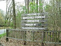
[Date]: 1966
[Location]: Rome34°15′03″N 85°11′43″W / 34.250898°N 85.195375°W / 34.250898; -85.195375 (Marshall Forest)
[County]: Floyd
[Ownership]: private
[Description]: A loblolly pine-shortleaf pine forest believed to have originated following an intense fire at about the time the Cherokee Indians were forcibly removed to Oklahoma. -
[]: 8
[Name]: Okefenokee Swamp
[Image]:
[Date]: 1974
[Location]: 30°37′00″N 82°19′00″W / 30.616667°N 82.316667°W / 30.616667; -82.316667 (Okefenokee Swamp)
[County]: Charlton, Clinch, Ware
[Ownership]: federal (Okefenokee National Wildlife Refuge)
[Description]: One of the largest and most primitive swamps in the country. -
[]: 9
[Name]: Panola Mountain
[Image]: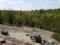
[Date]: 1980
[Location]: 33°38′07″N 84°10′13″W / 33.635278°N 84.170278°W / 33.635278; -84.170278 (Panola Mountain)
[County]: Rockdale
[Ownership]: state (Department of Natural Resources)
[Description]: The most natural and undisturbed monadnock of exposed granitic rock in the Piedmont biophysiographic province. -
[]: 10
[Name]: Wassaw Island
[Image]: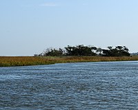
[Date]: 1967
[Location]: 31°54′01″N 80°58′56″W / 31.9003°N 80.9822°W / 31.9003; -80.9822 (Wassaw Island)
[County]: Chatham
[Ownership]: federal (Wassaw National Wildlife Refuge)
[Description]: Only barrier island in Georgia with an undisturbed forest cover. -
[]: 11
[Name]: Wade Tract Preserve
[Image]:
[Date]: 2014
[Location]: 30°45′N 84°00′W / 30.75°N 84°W / 30.75; -84 (Wade Tract Preserve)
[County]: Thomas
[Ownership]: private
[Description]: Old growth longleaf pine savanna.
New Random Display Display All Items(11)