


-
[]: 1
[Name]: Battell Biological Preserve
[Image]:
[Date]: 1976
[Location]:
[County]: Addison
[Ownership]: private
[Description]: A pristine, climax, New England forest. -
[]: 2
[Name]: Barton River Marsh
[Image]:
[Date]: 1973
[Location]:
[County]: Orleans
[Ownership]: state
[Description]: A large, shallow, freshwater marsh considered one of the best in New England. -
[]: 3
[Name]: Camel's Hump
[Image]: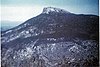
[Date]: 1968
[Location]: 44°19′10″N 72°53′11″W / 44.319547°N 72.886328°W / 44.319547; -72.886328 (Camel's Hump)
[County]: Chittenden, Washington
[Ownership]: state
[Description]: Supports the second largest extent of alpine-tundra in Vermont. -
[]: 4
[Name]: Cornwall Marsh
[Image]:
[Date]: 1973
[Location]: 43°54′57″N 73°11′11″W / 43.915926°N 73.186342°W / 43.915926; -73.186342 (Cornwall Marsh)
[County]: Addison
[Ownership]: mixed- state, municipal, private
[Description]: The largest unbroken red maple swamp in Vermont. -
[]: 5
[Name]: Franklin Bog
[Image]:
[Date]: 1973
[Location]:
[County]: Franklin
[Ownership]: private
[Description]: A cold, northern sphagnum-heath bog. -
[]: 6
[Name]: Fisher-Scott Memorial Pines
[Image]:
[Date]: 1976
[Location]:
[County]: Bennington
[Ownership]: state
[Description]: An old-growth stand of white pine. -
[]: 7
[Name]: Gifford Woods
[Image]:
[Date]: 1980
[Location]: 43°40′34″N 72°48′39″W / 43.6762°N 72.8109°W / 43.6762; -72.8109 (Gifford Woods)
[County]: Rutland
[Ownership]: state
[Description]: An old-growth, northern hardwood, climax forest. -
[]: 8
[Name]: Little Otter Creek Marsh
[Image]:
[Date]: 1973
[Location]:
[County]: Addison
[Ownership]: mixed- state, private
[Description]: Considered the best large expanse of marsh land in Vermont -
[]: 9
[Name]: Lake Willoughby Natural Area
[Image]:
[Date]: 1967
[Location]: 44°45′07″N 72°03′46″W / 44.751944°N 72.062778°W / 44.751944; -72.062778 (Lake Willoughby Natural Area)
[County]: Orleans
[Ownership]: state
[Description]: The deepest lake in Vermont and one of the most significant and scenic examples of glacial erosion in the northeast. -
[]: 10
[Name]: Molly Bog
[Image]:
[Date]: 1973
[Location]:
[County]: Lamoille
[Ownership]: mixed- state, private
[Description]: A classic, early successional, cold northern bog. -
[]: 11
[Name]: Mount Mansfield
[Image]:
[Date]: 1980
[Location]: 44°32′38″N 72°48′52″W / 44.543947°N 72.81431°W / 44.543947; -72.81431 (Mount Mansfield)
[County]: Chittenden, Lamoille
[Ownership]: state
[Description]: Contains a virgin, red spruce- balsam fir forest, extensive alpine tundra, and rare arctic flora not found elsewhere in the northeast. -
[]: 12
[Name]: Chazy Fossil Reef
[Image]: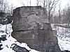
[Date]: 2009
[Location]: 44°51′10″N 73°20′24″W / 44.8528°N 73.34°W / 44.8528; -73.34 (Chazy Fossil Reef)
[County]: Grand Isle
[Ownership]: mixed- federal, state, private
[Description]: The oldest known occurrence of a biologically diverse fossil reef in the world.
New Random Display Display All Items(12)