


-
[]: 1
[Name]: Great Falls of Paterson-Garret Mountain
[Image]:
[Date]: January 1967; expanded April 1967
[Location]: Paterson 40°54′58″N 74°10′54″W / 40.916189°N 74.181597°W / 40.916189; -74.181597 (Great Falls of Paterson - Garret Mountain)
[County]: Passaic
[Ownership]: federal
[Description]: The Great Falls of the Passaic River and a later expansion including Garret Mountain help demonstrate how jointed basaltic lava flow shaped the geology of the area during the Early Mesozoic era through both extrusion and intrusion -
[]: 2
[Name]: Great Swamp
[Image]:
[Date]: May 1966
[Location]: Green Village 40°42′30″N 74°28′00″W / 40.708333°N 74.466667°W / 40.708333; -74.466667 (Great Swamp)
[County]: Morris and Somerset
[Ownership]: federal
[Description]: The remnant of the bottom of Glacial Lake Passaic which was formed by the melting waters of the retreating Wisconsin Glacier at the end of the last Ice Age. Established in 1960 as a National Wildlife Refuge now covering 7,600 acres (31 km2), it gained landmark status in 1966, and in 1968 became the first formally designated wilderness refuge in the United States. -
[]: 3
[Name]: Manahawkin Bottomland Hardwood Forest
[Image]:
[Date]: January 1976
[Location]: Manahawkin 39°41′08″N 74°13′18″W / 39.685591°N 74.221745°W / 39.685591; -74.221745 (Manahawkin Bottomland Hardwood Forest)
[County]: Ocean
[Ownership]: state
[Description]: A 965 acres (391 ha)[1] wildlife management area known for its mature bottomland hardwood forest which contains examples of American sweetgum, red maple and black gum trees. -
[]: 4
[Name]: Moggy Hollow Natural Area
[Image]:
[Date]: January 1970
[Location]: Far Hills 40°40′25″N 74°36′51″W / 40.67351°N 74.614055°W / 40.67351; -74.614055 (Moggy Hollow Natural Area)
[County]: Somerset
[Ownership]: private
[Description]: This narrow ravine is where Glacial Lake Passaic, pushed by the Wisconsin Glacier found an outlet, draining to the Raritan river. It remains today a nature preserve and an example of glacial geography. -
[]: 5
[Name]: Palisades of the Hudson
[Image]: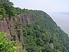
[Date]: June 1983
[Location]: Fort Lee to Rockleigh40°57′52″N 73°54′31″W / 40.964507°N 73.908591°W / 40.964507; -73.908591 (Palisades of the Hudson)
[County]: Bergen
[Ownership]: state
[Description]: Listed in New York, this dramatic geologic ridge runs along the Hudson River -
[]: 6
[Name]: Pigeon Swamp
[Image]:
[Date]: December 1976
[Location]: South Brunswick 40°23′13″N 74°28′26″W / 40.386893°N 74.473829°W / 40.386893; -74.473829 (Pigeon Swamp State Park)
[County]: Middlesex
[Ownership]: mixed- state, private
[Description]: An undeveloped state park, it holds a mix of upland and lowland hardwood forests. It was a major nesting site for passenger pigeons before they became extinct. -
[]: 7
[Name]: Riker Hill Fossil Site
[Image]:
[Date]: June 1971
[Location]: Roseland 40°48′57″N 74°19′36″W / 40.815705°N 74.326678°W / 40.815705; -74.326678 (Riker Hill Fossil Site)
[County]: Essex
[Ownership]: county
[Description]: Over 1,000 Dinosaur, animal and insect tracks from the Late Triassic and Early Jurassic periods were discovered here in 1968 in a former stone quarry. -
[]: 8
[Name]: Stone Harbor Bird Sanctuary
[Image]:
[Date]: October 1965
[Location]: Stone Harbor 39°02′30″N 74°46′08″W / 39.04164°N 74.76879°W / 39.04164; -74.76879 (Stone Harbor Bird Sanctuary)
[County]: Cape May
[Ownership]: municipal
[Description]: A 21.5-acre (8.7 ha) bird sanctuary and nature preserve which used to host annually returning herons and egrets for nesting season until they started disappearing in the late 1990s. -
[]: 9
[Name]: Sunfish Pond
[Image]:
[Date]: January 1970
[Location]: Columbia 41°00′11″N 75°04′23″W / 41.003043°N 75.073099°W / 41.003043; -75.073099 (Sunfish Pond)
[County]: Warren
[Ownership]: state
[Description]: This glacial pond is a favorite hiking destination in Worthington State Forest, adjacent to the Delaware Water Gap National Recreation Area. Supreme Court Justice William O. Douglas mentioned the pond in his dissenting opinion in the Sierra Club v. Morton case. -
[]: 10
[Name]: Troy Meadows
[Image]:
[Date]: 1967
[Location]: Parsippany-Troy Hills 40°50′46″N 74°22′45″W / 40.846026°N 74.37928°W / 40.846026; -74.37928 (Troy Meadows)
[County]: Morris
[Ownership]: mixed- state, private
[Description]: The last unpolluted freshwater marsh of large size in the region. -
[]: 11
[Name]: William L. Hutcheson Memorial Forest
[Image]:
[Date]: December 1976
[Location]: Somerset 40°30′01″N 74°34′02″W / 40.500405°N 74.567245°W / 40.500405; -74.567245 (Hutcheson Memorial Forest)
[County]: Somerset
[Ownership]: state
[Description]: A 500 acres (200 ha) nature preserve which includes a 65 acres (26 ha) virgin old growth forest. It's jointly managed by Rutgers University and the Nature Conservancy.
New Random Display Display All Items(11)