


-
[]: 1
[Name]: Big Oak Tree State Park
[Image]: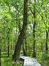
[Date]: May 1986
[Location]: East Prairie 36°39′18″N 89°19′42″W / 36.655°N 89.32833°W / 36.655; -89.32833 (Big Oak Tree State Park)
[County]: Mississippi
[Ownership]: state
[Description]: A rare untouched wet-mesic bottomland hardwood forest in the Mississippi Alluvial Plain, it is the home of several state and national champion trees -
[]: 2
[Name]: Carroll Cave
[Image]:
[Date]: 1977
[Location]:
[County]: Camden
[Ownership]: private
[Description]: Contains a dendritic system of subsurface karst streams and tributaries. -
[]: 3
[Name]: Cupola Pond
[Image]:
[Date]: 1974
[Location]:
[County]: Ripley
[Ownership]: federal
[Description]: One of the most ancient sinkhole ponds in the Ozark plateaus. Located in Mark Twain National Forest. -
[]: 4
[Name]: Golden Prairie
[Image]:
[Date]: 1975
[Location]: Golden City 37°21′45″N 94°09′01″W / 37.36261°N 94.15019°W / 37.36261; -94.15019 (Golden Prairie)
[County]: Barton
[Ownership]: private
[Description]: An unplowed remnant of the tall grass prairie ecosystem. -
[]: 5
[Name]: Grand Gulf State Park
[Image]:
[Date]: June 1971
[Location]: Thayer 36°31′27″N 91°32′38″W / 36.52427°N 91.54389°W / 36.52427; -91.54389 (Grand Gulf State Park)
[County]: Oregon
[Ownership]: state
[Description]: An excellent example of karst topography, this canyon is a collapsed dolomite cave with a 200 feet (61 m) natural bridge. Water in this canyon emerges 9 miles (14 km) away in Mammoth Spring, Arkansas. -
[]: 6
[Name]: Greer Spring
[Image]:
[Date]: 1980
[Location]: 36°47′12″N 91°20′51″W / 36.786667°N 91.3475°W / 36.786667; -91.3475 (Greer Spring)
[County]: Oregon
[Ownership]: private
[Description]: Spring in the Ozarks that discharges into a high quality, cascading stream. -
[]: 7
[Name]: Maple Woods Natural Area
[Image]:
[Date]: 1980
[Location]:
[County]: Clay
[Ownership]: state
[Description]: Contains a nearly virgin sugar maple and mockernut hickory forest. -
[]: 8
[Name]: Maramec Spring
[Image]: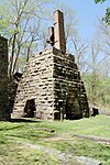
[Date]: October 1971
[Location]: St. James 37°57′19″N 91°32′11″W / 37.95526°N 91.53632°W / 37.95526; -91.53632 (Maramec Spring)
[County]: Phelps
[Ownership]: private
[Description]: A natural spring, the fifth largest in the state. It has a notable trout park and a historic iron works in a privately owned park. -
[]: 9
[Name]: Mark Twain and Cameron Caves
[Image]:
[Date]: 1972
[Location]: 39°41′19″N 91°19′54″W / 39.68864°N 91.33153°W / 39.68864; -91.33153 (Mark Twain Cave)
[County]: Marion
[Ownership]: private
[Description]: Exceptionally good examples of the maze type of cavern development. -
[]: 10
[Name]: Marvel Cave
[Image]: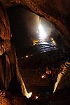
[Date]: 1972
[Location]: 36°40′03″N 93°20′23″W / 36.6675°N 93.3397°W / 36.6675; -93.3397 (Marvel Cave)
[County]: Stone
[Ownership]: private
[Description]: Includes one of the greatest dripstone units of all the Ozark caves. -
[]: 11
[Name]: Onondaga Cave State Park
[Image]:
[Date]: 1980
[Location]: 38°03′39″N 91°13′38″W / 38.060833°N 91.227222°W / 38.060833; -91.227222 (Onondaga Cave State Park)
[County]: Crawford
[Ownership]: state
[Description]: Contains an unusually large and varied number of speleothems. -
[]: 12
[Name]: Pickle Springs
[Image]:
[Date]: 1975
[Location]:
[County]: Ste. Genevieve
[Ownership]: state
[Description]: Contains one of the finest Pleistocene relict habitats in Missouri. -
[]: 13
[Name]: Taberville Prairie
[Image]:
[Date]: 1975
[Location]:
[County]: St. Clair
[Ownership]: state
[Description]: One of the largest remaining virgin tall grass prairies. -
[]: 14
[Name]: Tucker Prairie
[Image]:
[Date]: 1975
[Location]:
[County]: Callaway
[Ownership]: private
[Description]: A virgin tall grass prairie occurring within the transition zone between the oak-hickory forest and typical tall grass prairie. -
[]: 15
[Name]: Tumbling Creek Cave
[Image]:
[Date]: 1980
[Location]:
[County]: Taney
[Ownership]: private
[Description]: Contains the most diverse fauna known for any cave west of the Mississippi River. -
[]: 16
[Name]: Wegener Woods
[Image]:
[Date]: 1975
[Location]:
[County]: Warren
[Ownership]: private
[Description]: An essentially virgin oak-hickory-dominated forest in a condition of gradual change to a sugar maple-dominated forest.
New Random Display Display All Items(16)