


-
[]: 1
[Name]: Appleton Bog Atlantic White Cedar Stand
[Image]:
[Date]: 1984
[Location]:
[County]: Knox
[Ownership]: private
[Description]: A large peatland with continuous forest cover and well-developed hummock-and- hollow topography. -
[]: 2
[Name]: Carrying Place Cove Bog
[Image]:
[Date]: 1980
[Location]:
[County]: Washington
[Ownership]: state
[Description]: A tombolo that has been eroded by the sea. -
[]: 3
[Name]: Colby-Marston Preserve
[Image]:
[Date]: 1973
[Location]:
[County]: Kennebec
[Ownership]: private
[Description]: Northern sphagnum bog located in a deep kettle hole, the sphagnum mat exceeds a depth of 40 feet (12 m). -
[]: 4
[Name]: Crystal Bog
[Image]:
[Date]: 1973
[Location]: 46°02′04″N 68°19′49″W / 46.034472°N 68.330394°W / 46.034472; -68.330394 (Crystal Bog)
[County]: Aroostook
[Ownership]: private
[Description]: An undisturbed, sphagnum bog considered one of the largest and finest in Maine. -
[]: 5
[Name]: Gulf Hagas
[Image]:
[Date]: 1968
[Location]: 45°29′03″N 69°19′23″W / 45.4841°N 69.323°W / 45.4841; -69.323 (Gulf Hagas)
[County]: Piscataquis
[Ownership]: federal (Appalachian Trail)
[Description]: Waterfalls, cliffs, and growth of spruce-fir forest on the gorge walls give the site unusual scenic beauty. -
[]: 6
[Name]: The Hermitage
[Image]:
[Date]: 1977
[Location]:
[County]: Piscataquis
[Ownership]: federal (Appalachian Trail)
[Description]: One of the few undisturbed, old-growth white pine stands remaining in New England. -
[]: 7
[Name]: Monhegan Island
[Image]:
[Date]: 1966
[Location]: 43°45′44″N 69°19′13″W / 43.762222°N 69.320278°W / 43.762222; -69.320278 (Monhegan Island)
[County]: Lincoln
[Ownership]: private
[Description]: Dense, almost pure stands of red spruce and over 400 species of wildflower. -
[]: 8
[Name]: Mount Bigelow (Maine)
[Image]:
[Date]: 1975
[Location]: 45°08′50″N 70°17′21″W / 45.147277°N 70.289234°W / 45.147277; -70.289234 (Mount Bigelow (Maine))
[County]: Franklin, Somerset
[Ownership]: state
[Description]: Exceptionally scenic and wild, with some of the best summit views in the eastern United States. -
[]: 9
[Name]: Mount Katahdin
[Image]:
[Date]: 1967
[Location]: 45°54′16″N 68°55′17″W / 45.904354°N 68.921274°W / 45.904354; -68.921274 (Mount Katahdin)
[County]: Piscataquis
[Ownership]: state (Baxter State Park)
[Description]: Kames, eskers, drumlins, kettleholes, moraines, and erratics provide a complete illustration of glacial geology. -
[]: 10
[Name]: New Gloucester Black Gum Stand
[Image]:
[Date]: 1975
[Location]:
[County]: Cumberland
[Ownership]: private
[Description]: A small, remnant, forested swamp dominated mostly by virgin black gum. -
[]: 11
[Name]: No. 5 Bog and Jack Pine Stand
[Image]:
[Date]: 1984
[Location]:
[County]: Somerset
[Ownership]: state, private
[Description]: The only large, intermontane peatland and one of the few expansive, virgin landscapes in the northeastern United States. -
[]: 12
[Name]: Orono Bog
[Image]: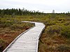
[Date]: 1973
[Location]: 44°52′09″N 68°43′32″W / 44.86907°N 68.725668°W / 44.86907; -68.725668 (Orono Bog)
[County]: Penobscot
[Ownership]: municipal, private
[Description]: A classic northern sphagnum bog. -
[]: 13
[Name]: Passadumkeag Marsh and Bogland
[Image]:
[Date]: 1973
[Location]:
[County]: Penobscot
[Ownership]: private
[Description]: One of the largest, unspoiled wetlands in the state of Maine. -
[]: 14
[Name]: Penny Pond-Joe Pond Complex
[Image]:
[Date]: 1973
[Location]:
[County]: Kennebec
[Ownership]: private
[Description]: Kettle hole bogs and ponds.
New Random Display Display All Items(14)