


-
[Site]: Ancient Tombs on the Donggou River洞沟古墓群
[Date]: Koguryo
[Location]: Ji'an
[Image]: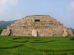

[Coordinates]: 41°08′52″N 126°13′13″E / 41.147832°N 126.220357°E / 41.147832; 126.220357 (Ancient Tombs on the Donggou River)
[Designation]: 1-168 -
[Site]: Ancient Tombs at Liuding Mountain六顶山古墓群
[Date]: Balhae
[Location]: Dunhua
[Image]:
[Coordinates]: 43°55′02″N 126°28′19″E / 43.917201°N 126.471916°E / 43.917201; 126.471916 (Ancient Tombs at Liuding Mountain)
[Designation]: 1-173 -
[Site]: Hwando Mountain City and Gungnae City丸都山城与国内城
[Date]: Goguryo
[Location]: Ji'an
[Image]:
[Coordinates]: 41°09′55″N 126°09′28″E / 41.165183°N 126.157722°E / 41.165183; 126.157722 (Hwando Mountain City and Gungnae City)
[Designation]: 2-52 -
[Site]: Lingguang Pagoda灵光塔
[Date]: Balhae
[Location]: Changbai Korean Autonomous County
[Image]:
[Coordinates]: 41°25′29″N 128°11′20″E / 41.424701°N 128.188809°E / 41.424701; 128.188809 (Lingguang Pagoda)
[Designation]: 3-141 -
[Site]: Great Jin Dynasty Memorial Stele大金得胜陀颂碑
[Date]: Jin
[Location]: Fuyu County
[Image]:
[Coordinates]: 45°20′49″N 125°37′07″E / 45.346944°N 125.618611°E / 45.346944; 125.618611 (Great Jin Dynasty Memorial Stele)
[Designation]: 3-178 -
[Site]: Ancient Tombs at Longtou Mountain龙头山古墓群
[Date]: Balhae
[Location]: Helong
[Image]:
[Coordinates]: 42°45′00″N 129°12′00″E / 42.750000°N 129.200000°E / 42.750000; 129.200000 (Ancient Tombs at Longtou Mountain)
[Designation]: 3-244 -
[Site]: Site of the Middle Capital of the Balhae Kingdom渤海中京城遗址
[Date]: Balhae
[Location]: Helong
[Image]:
[Coordinates]: 42°42′48″N 129°08′29″E / 42.713313°N 129.141455°E / 42.713313; 129.141455 (Site of the Middle Capital of the Balhae Kingdom)
[Designation]: 4-51 -
[Site]: Mao'ershan Tombs帽儿山墓地
[Date]: Han
[Location]: Jilin
[Image]:
[Coordinates]: 43°50′53″N 126°37′39″E / 43.848053°N 126.627603°E / 43.848053; 126.627603 (Mao'ershan Tombs)
[Designation]: 4-62 -
[Site]: Hanshu Site汉书遗址
[Date]: Bronze Age
[Location]: Da'an
[Image]:
[Coordinates]: 45°41′52″N 124°01′22″E / 45.697853°N 124.022784°E / 45.697853; 124.022784 (Hanshu Site)
[Designation]: 5-26 -
[Site]: Xituanshan Site西团山遗址
[Date]: Bronze Age
[Location]: Jilin
[Image]:
[Coordinates]: 43°51′14″N 126°36′13″E / 43.854007°N 126.603668°E / 43.854007; 126.603668 (Xituanshan Site)
[Designation]: 5-27 -
[Site]: Wanfabozi Site万发拨子遗址
[Date]: Warring States to Jin
[Location]: Tonghua
[Image]:
[Coordinates]: 41°41′44″N 125°56′07″E / 41.695540°N 125.935280°E / 41.695540; 125.935280 (Wanfabozi Site)
[Designation]: 5-28 -
[Site]: Erlonghu Site二龙湖古城遗址
[Date]: Warring States
[Location]: Lishu County
[Image]:
[Coordinates]: 43°11′31″N 124°47′38″E / 43.192027°N 124.793871°E / 43.192027; 124.793871 (Erlonghu Site)
[Designation]: 5-29 -
[Site]: Luotongshan罗通山城
[Date]: Han to Jin
[Location]: Liuhe County
[Image]:
[Coordinates]:
[Designation]: 5-30 -
[Site]: Baliancheng Site八连城遗址
[Date]: Tang to Five Dynasties
[Location]: Hunchun
[Image]:
[Coordinates]: 42°51′31″N 130°16′59″E / 42.8586°N 130.283°E / 42.8586; 130.283 (Baliancheng Site)
[Designation]: 5-31 -
[Site]: Copper Smelting Sites of Baoshan and Liudaogou宝山—六道沟冶铜遗址
[Date]: Tang to Five Dynasties
[Location]: Linjiang
[Image]:
[Coordinates]:
[Designation]: 5-32 -
[Site]: Tahucheng Site塔虎城
[Date]: Liao to Jin
[Location]: Qian Gorlos Mongol Autonomous County
[Image]:
[Coordinates]: 45°23′39″N 124°21′27″E / 45.394079°N 124.357483°E / 45.394079; 124.357483 (Tahucheng Site)
[Designation]: 5-33 -
[Site]: Gangouzi Tombs干沟子墓群
[Date]: Warring States to Western Han
[Location]: Changbai Korean Autonomous County
[Image]:
[Coordinates]: 41°26′34″N 127°57′13″E / 41.442719°N 127.953575°E / 41.442719; 127.953575 (Gangouzi Tombs)
[Designation]: 5-157 -
[Site]: Family cemetery of Wanyan Xiyin完颜希尹家族墓地
[Date]: Jin
[Location]: Shulan
[Image]:
[Coordinates]:
[Designation]: 5-158 -
[Site]: Baicaogou Site百草沟遗址
[Date]: Warring States to Jin
[Location]: Wangqing County
[Image]:
[Coordinates]: 42°51′10″N 128°04′31″E / 42.852797°N 128.075291°E / 42.852797; 128.075291 (Baicaogou Site)
[Designation]: 6-51 -
[Site]: Zi'an Shancheng自安山城
[Date]: Northern and Southern Dynasties
[Location]: Tonghua
[Image]:
[Coordinates]: 41°45′34″N 125°57′52″E / 41.759569°N 125.964488°E / 41.759569; 125.964488 (Zi'an Shancheng)
[Designation]: 6-52 -
[Site]: Longtanshan Fortress龙潭山城
[Date]: Jin
[Location]: Ji'an
[Image]:
[Coordinates]:
[Designation]: 6-53 -
[Site]: Sumi Fortress苏密城
[Date]: Tang
[Location]: Huadian
[Image]:
[Coordinates]: 42°59′25″N 126°46′54″E / 42.990139°N 126.781786°E / 42.990139; 126.781786 (Sumi Fortress)
[Designation]: 6-54 -
[Site]: Chengshanzi Mountain Site城山子山城
[Date]: Tang
[Location]: Dunhua
[Image]:
[Coordinates]:
[Designation]: 6-55 -
[Site]: Mopancun Mountain Site磨盘村山城
[Date]: Tang to Jin
[Location]: Tumen
[Image]:
[Coordinates]:
[Designation]: 6-56 -
[Site]: Pianliancheng Site偏脸城城址
[Date]: Liao to Jin
[Location]: Lishu County
[Image]:
[Coordinates]: 43°21′25″N 124°19′40″E / 43.357031°N 124.327723°E / 43.357031; 124.327723 (Pianliancheng Site)
[Designation]: 6-57 -
[Site]: Qinjiatun Site秦家屯城址
[Date]: Liao to Jin
[Location]: Gongzhuling
[Image]:
[Coordinates]:
[Designation]: 6-58 -
[Site]: Chengsijiazi Site城四家子城址
[Date]: Liao to Yuan
[Location]: Baicheng
[Image]:
[Coordinates]: 45°23′05″N 122°55′50″E / 45.384658°N 122.930593°E / 45.384658; 122.930593 (Chengsijiazi Site)
[Designation]: 6-59 -
[Site]: Yehebu Site叶赫部城址
[Date]: Ming
[Location]: Siping
[Image]:
[Coordinates]:
[Designation]: 6-60 -
[Site]: Huifa Site辉发城址
[Date]: Ming
[Location]: Huinan County
[Image]:
[Coordinates]:
[Designation]: 6-61 -
[Site]: Dolmens on the Upper Reaches of the Huifa River辉发河上游石棚墓
[Date]: Zhou
[Location]: Meihekou
[Image]:
[Coordinates]:
[Designation]: 6-244 -
[Site]: Jilin Confucian Temple吉林文庙
[Date]: Qing
[Location]: Jilin
[Image]:
[Coordinates]: 43°50′28″N 126°34′14″E / 43.840991°N 126.570569°E / 43.840991; 126.570569 (Jilin Confucian Temple)
[Designation]: 6-502 -
[Site]: Ashihada Stone Inscriptions阿什哈达摩崖
[Date]: Ming
[Location]: Jilin
[Image]:
[Coordinates]: 43°46′06″N 126°40′11″E / 43.768368°N 126.669855°E / 43.768368; 126.669855 (Ashihada Stone Inscriptions)
[Designation]: 6-820 -
[Site]: Headquarters of the Linjiang Campaign四保临江战役指挥部旧址
[Date]: 1945
[Location]: Linjiang
[Image]:
[Coordinates]: 41°48′21″N 126°55′04″E / 41.805952°N 126.917811°E / 41.805952; 126.917811 (Headquarters in the Linjiang Campaign)
[Designation]: 6-921
New Random Display Display All Items(33)