


-
[SL. No.]: N-OR-1
[Description]: [Chausatti Jogini temple together with three minor shrines]
[Location]: Ranipur Jharial
[Address]: Ranipur Jharial, Balangir
[District]: Balangir
[Coordinates]:
[Image]:
(List of monuments) -
[SL. No.]: N-OR-2
[Description]: Ruined fortress, Budhalinga Temple
[Location]: Agrahat, Bandals, Chaudar, Chhatisa, Govind Jew, Patna, Jaj, Bhariab, Kapaleswar, Kedareswar, Mundmal
[Address]: Agrahat, Choudwar, Cuttack
[District]: Cuttack
[Coordinates]:
[Image]: [[File:|150x150px|center|border|Ruined fortress, Budhalinga Temple]]
(List of monuments) -
[SL. No.]: N-OR-3
[Description]: Ruins of the Buddhist temples and images
[Location]: Bandareswar
[Address]:
[District]: Cuttack
[Coordinates]:
[Image]:
(List of monuments) -
[SL. No.]: N-OR-4
[Description]: Bhubaneswar Mahadev temple
[Location]: Bhabanipur (Balia Taluk)
[Address]: On the Bank of River Biluakhai, Balia, Jagatsinghpur
[District]: Jagatsinghpur
[Coordinates]:
[Image]:
(List of monuments) -
[SL. No.]: N-OR-5
[Description]: Hill containing many valuable sculptures, images and inscriptions, etc., of Buddhistic age. On the top, there is a math and a small temple of Mahakal
[Location]: Chandia
[Address]:
[District]: Cuttack
[Coordinates]:
[Image]:
(List of monuments) -
[SL. No.]: N-OR-6
[Description]: Ancient monuments of Barabati Fortress and the ruins and remains of all ancient edifices, gateways, etc., save the mosque
[Location]: Cuttack
[Address]: Barabati Fort Rd, Biju Patnaik Colony, Cuttack, Odisha 753008
[District]: Cuttack
[Coordinates]: 20°29′05″N 85°51′52″E / 20.48463056°N 85.864425°E / 20.48463056; 85.864425 (SL. No. N-OR-6)
[Image]:
(List of monuments) -
[SL. No.]: N-OR-7
[Description]: Churangarh Fort locally known as Sarangarh, excluding the area acquired by the State Government
[Location]: Dadhapatna
[Address]:
[District]: Cuttack
[Coordinates]:
[Image]:
(List of monuments) -
[SL. No.]: N-OR-8
[Description]: Four colossal images in the compound of Jajpur the sub-divisional Officers Quarters, namely :-1) Chamunda, 2) Indrani, 3) Kalijuga, 4) Varahi
[Location]: Jajpur
[Address]:
[District]: Cuttack
[Coordinates]:
[Image]:
(List of monuments) -
[SL. No.]: N-OR-9
[Description]: Three Buddhist images
[Location]: Jajpur
[Address]:
[District]: Cuttack
[Coordinates]:
[Image]:
(List of monuments) -
[SL. No.]: N-OR-10
[Description]: Ruins of Buddhist temples and images
[Location]: Naltigiri (Lalitagiri)
[Address]: Lalitagiri, Balichandrapur, Jajapur
[District]: Jajapur
[Coordinates]:
[Image]:
(List of monuments) -
[SL. No.]: N-OR-11
[Description]: Major ruined Buddhist site with 3 monasteries and hundreds of stupas; abundant sculpture
[Location]: Ratnagiri
[Address]: Ratnagiri, Jajapur, Odisha 755003
[District]: Jajapur
[Coordinates]:
[Image]:
(List of monuments) -
[SL. No.]: N-OR-12
[Description]: Mahratta bridge locally known as the Atharnulla (eighteen arches bridge) and also as Tentulimal bridge
[Location]: Siriapur
[Address]:
[District]: Cuttack
[Coordinates]:
[Image]:
(List of monuments) -
[SL. No.]: N-OR-13
[Description]: Monolith called Chandeswar Pillar
[Location]: Siriapur
[Address]:
[District]: Cuttack
[Coordinates]:
[Image]:
(List of monuments) -
[SL. No.]: N-OR-14
[Description]: Simhanatha Mahadeva temple
[Location]: Simhanatha Pitha, Mauza Gopinathpur
[Address]: Gopinathpur, Baramba, Cuttack
[District]: Cuttack
[Coordinates]:
[Image]:
(List of monuments) -
[SL. No.]: N-OR-15
[Description]: Pancha Pandava temple
[Location]: Ganeswarpur
[Address]: Ganeswarpur, Near Chhatia, Cuttack
[District]: Cuttack
[Coordinates]:
[Image]: [[File:|150x150px|center|border|Pancha Pandava temple]]
(List of monuments) -
[SL. No.]: N-OR-16
[Description]: Durga temple
[Location]: Baideswar
[Address]: AT/PO-Baideswar, Banki, Cuttack
[District]: Cuttack
[Coordinates]:
[Image]: [[File:|150x150px|center|border|Durga temple]]
(List of monuments) -
[SL. No.]: N-OR-17
[Description]: Ancient site at Baneswaranasi
[Location]: Padamal Pattana
[Address]: Baneswarnasi, Ekadal, Narasinghpur, Cuttack
[District]: Cuttack
[Coordinates]:
[Image]: [[File:|150x150px|center|border|Ancient site at Baneswaranasi]]
(List of monuments) -
[SL. No.]: N-OR-18
[Description]: Mahimamani Temple
[Location]: Ragadi (Banki)
[Address]: AT/PO-Ragadi, Banki, Cuttack
[District]: Cuttack
[Coordinates]:
[Image]: [[File:|150x150px|center|border|Mahimamani Temple]]
(List of monuments) -
[SL. No.]: N-OR-19
[Description]: Ancient site at Chowdar, Budhalinga Temple
[Location]: Chowdar
[Address]: Chaudwar, Cuttack
[District]: Cuttack
[Coordinates]:
[Image]:
(List of monuments) -
[SL. No.]: N-OR-20
[Description]: Bringesvara Mahadeva temple
[Location]: Bajrakot
[Address]: AT/PO-Bajrakota, Rengali Town, Angul
[District]: Angul
[Coordinates]:
[Image]:
(List of monuments) -
[SL. No.]: N-OR-21
[Description]: Rock-cut Vishnu
[Location]: Rasol
[Address]:
[District]: Dhenkanal
[Coordinates]:
[Image]:
(List of monuments) -
[SL. No.]: N-OR-22
[Description]: Gangadharaswami temple
[Location]: Kottakolla, Budhakhol
[Address]: Kottakola, Budhakhol, Buguda
[District]: Ganjam
[Coordinates]:
[Image]:
(List of monuments) -
[SL. No.]: N-OR-23
[Description]: Jagdiswaraswami temple
[Location]: Kottakolla, Budhakhol
[Address]: Kottakola, Budhakhol, Buguda
[District]: Ganjam
[Coordinates]:
[Image]:
(List of monuments) -
[SL. No.]: N-OR-24
[Description]: Bhima temple
[Location]: Mahendragiri
[Address]:
[District]: Gajapati
[Coordinates]:
[Image]:
(List of monuments) -
[SL. No.]: N-OR-25
[Description]: Kunti temple
[Location]: Mahendragiri
[Address]:
[District]: Gajapati
[Coordinates]:
[Image]:
(List of monuments) -
[SL. No.]: N-OR-26
[Description]: Yudhistra temple
[Location]: Mahendragiri
[Address]:
[District]: Gajapati
[Coordinates]:
[Image]:
(List of monuments) -
[SL. No.]: N-OR-27
[Description]: Asoka rock inscriptions at Jaugada
[Location]: Pandya
[Address]: Purussottampur, Ganjam
[District]: Ganjam
[Coordinates]:
[Image]: [[File:|150x150px|center|border|Asoka rock inscriptions at Jaugada]]
(List of monuments) -
[SL. No.]: N-OR-28
[Description]: Prehistoric sites
[Location]: Baidyapur
[Address]:
[District]: MayurBhanj
[Coordinates]:
[Image]:
(List of monuments) -
[SL. No.]: N-OR-29
[Description]: Ruins of ancient fort
[Location]: Haripurgarh
[Address]:
[District]: MayurBhanj
[Coordinates]:
[Image]:
(List of monuments) -
[SL. No.]: N-OR-30
[Description]: Prehistoric sites
[Location]: Kuchai
[Address]:
[District]: MayurBhanj
[Coordinates]:
[Image]:
(List of monuments) -
[SL. No.]: N-OR-31
[Description]: Prehistoric sites
[Location]: Kuliana
[Address]:
[District]: MayurBhanj
[Coordinates]:
[Image]:
(List of monuments) -
[SL. No.]: N-OR-32
[Description]: Paintings on the rock locally known as Ravana Chhaya and other ancient monuments and remains
[Location]: Sitabhanji
[Address]:
[District]: Keonjhar
[Coordinates]:
[Image]:
(List of monuments) -
[SL. No.]: N-OR-33
[Description]: Ancient site of Asurgarh fort
[Location]: Asurgarh
[Address]:
[District]: Kalahandi
[Coordinates]:
[Image]:
(List of monuments) -
[SL. No.]: N-OR-34
[Description]: Temple of Nilamadhava and Sidheswara
[Location]: Gandharadhi
[Address]: Gandharadi, Jgati, Boudh
[District]: Boudh
[Coordinates]:
[Image]: [[File:|150x150px|center|border|Temple of Nilamadhava and Sidheswara]]
(List of monuments) -
[SL. No.]: N-OR-35
[Description]: Paschima Somnatha, Bhubanesvara and Kapilesvara temples
[Location]: Boudh
[Address]: Boudh Town
[District]: Boudh
[Coordinates]:
[Image]: [[File:|150x150px|center|border|Paschima Somnatha, Bhubanesvara and Kapilesvara temples]]
(List of monuments) -
[SL. No.]: N-OR-36
[Description]: Bhaskareswar temple
[Location]: Badagada
[Address]: Tankapani Road, Bhubaneswar
[District]: Khordha
[Coordinates]:
[Image]:
(List of monuments) -
[SL. No.]: N-OR-37
[Description]: Brahmeswar temple with its minar shrines in the compound
[Location]: Bhubaneswar
[Address]: Near, Tankapani Rd, Siba Nagar, Brahmeswarpatna, Bhubaneswar, Odisha 751002
[District]: Khurdha
[Coordinates]: 20°14′23″N 85°51′06″E / 20.2397341°N 85.8517267°E / 20.2397341; 85.8517267 (SL. No. N-OR-37)
[Image]:
(List of monuments) -
[SL. No.]: N-OR-38
[Description]: Nabakeswar Temple
[Location]: Nageswar Tangi
[Address]: Nageswar Tangi, Old Town, Bhubaneswar
[District]: Khordha
[Coordinates]:
[Image]:
(List of monuments) -
[SL. No.]: N-OR-39
[Description]: Rameswar Temple
[Location]: Mausima Chowk
[Address]: Mausima Chowk, Old Town, Bhubaneswar
[District]: Khordha
[Coordinates]:
[Image]:
(List of monuments) -
[SL. No.]: N-OR-40
[Description]: Magheswar temple with its minar shrine
[Location]: Megheswar Colony
[Address]: Tankapani Road, Bhubaneswar
[District]: Khordha
[Coordinates]:
[Image]:
(List of monuments) -
[SL. No.]: N-OR-41
[Description]: Ananta Vasudeva Temple
[Location]: Old Town, Bhubaneswar
[Address]: Lingaraj Temple oad, Old Town, Bhubaneswar
[District]: Khurda
[Coordinates]: 20°14′26″N 85°50′09″E / 20.24060556°N 85.83578056°E / 20.24060556; 85.83578056 (SL. No. N-OR-41)
[Image]: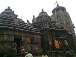
(List of monuments) -
[SL. No.]: N-OR-42
[Description]: Bakeswar temple
[Location]: Bhubaneswar
[Address]: Old Town, Bhubaneswar
[District]: Khurda
[Coordinates]:
[Image]: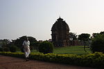
(List of monuments) -
[SL. No.]: N-OR-43
[Description]: Chitrakarni temple
[Location]: Bhubaneswar
[Address]: Old Town, Bhubaneswar
[District]: Khurda
[Coordinates]:
[Image]:
(List of monuments) -
[SL. No.]: N-OR-44
[Description]: Jameswar Temple with its minar shrine
[Location]: Bhubaneswar
[Address]: Old Town, Bhubaneswar
[District]: Khurda
[Coordinates]: 20°14′25″N 85°49′53″E / 20.24027778°N 85.83138889°E / 20.24027778; 85.83138889 (SL. No. N-OR-44)
[Image]:
(List of monuments) -
[SL. No.]: N-OR-45
[Description]: Lord Lingaraj Temple with all the minar temples in the compound namely: 1. Amania well, 2. Astmurti, 3. Chandeswar Deb, 4. Gopaluni temple, 5. Ladukeswar temple, 6. Parbati temple, 7. Sabitri Devi temple, 8. Sakreswar temple, 9. Sathidosi temple
[Location]: Bhubaneswar
[Address]: Old Town, Bhubaneswar
[District]: Khurda
[Coordinates]:
[Image]: More images
(List of monuments) -
[SL. No.]: N-OR-46
[Description]: Maitreswar temple with all the minar temples in the compound
[Location]: Bhubaneswar
[Address]: Old Town, Bhubaneswar
[District]: Khurda
[Coordinates]:
[Image]:
(List of monuments) -
[SL. No.]: N-OR-47
[Description]: Makareswar temple with its minar
[Location]: Bhubaneswar
[Address]: Old Town, Bhubaneswar
[District]: Khurda
[Coordinates]:
[Image]:
(List of monuments) -
[SL. No.]: N-OR-48
[Description]: Markandeswar temple
[Location]: Bhubaneswar
[Address]: Old Town, Bhubaneswar
[District]: Khurda
[Coordinates]:
[Image]:
(List of monuments) -
[SL. No.]: N-OR-49
[Description]: Mukteswar temple with its minar shrines but excluding the Murich Kunda.
[Location]: Bhubaneswar
[Address]: Old Town, Bhubaneswar
[District]: Khurda
[Coordinates]:
[Image]: More images
(List of monuments) -
[SL. No.]: N-OR-50
[Description]: Paramguru temple
[Location]: Bhubaneswar
[Address]: Old Town, Bhubaneswar
[District]: Khurda
[Coordinates]:
[Image]:
(List of monuments) -
[SL. No.]: N-OR-51
[Description]: Papnasini Tank
[Location]: Bhubaneswar
[Address]: Old Town, Bhubaneswar
[District]: Khurda
[Coordinates]:
[Image]:
(List of monuments) -
[SL. No.]: N-OR-52
[Description]: Parsurameswar Temple
[Location]: Bhubaneswar
[Address]: Old Town, Bhubaneswar
[District]: Khurda
[Coordinates]:
[Image]: More images
(List of monuments) -
[SL. No.]: N-OR-53
[Description]: Rajarani Temple
[Location]: Bhubaneswar
[Address]: Tankapani Road, Bhubaneswar
[District]: Khurda
[Coordinates]:
[Image]: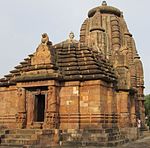 More images
(List of monuments) -
[SL. No.]: N-OR-54
[Description]: Sahasralinga Tank
[Location]: Bhubaneswar
[Address]:
[District]: Khurda
[Coordinates]:
[Image]:
(List of monuments) -
[SL. No.]: N-OR-55
[Description]: Sari Deul
[Location]: Bhubaneswar
[Address]: Old Town, Bhubaneswar
[District]: Khurda
[Coordinates]:
[Image]:
(List of monuments) -
[SL. No.]: N-OR-56
[Description]: Sidheswar temple
[Location]: Bhubaneswar
[Address]: Old Town, Bhubaneswar
[District]: Khurda
[Coordinates]:
[Image]: More images
(List of monuments) -
[SL. No.]: N-OR-57
[Description]: Sisiresvara temple
[Location]: Bhubaneswar
[Address]: Old Town, Bhubaneswar
[District]: Khurda
[Coordinates]:
[Image]:
(List of monuments) -
[SL. No.]: N-OR-58
[Description]: Varahi temple
[Location]: Chaurasi
[Address]: Charichhak-Kakatpur Road, Amareswar, Chaurasi, Puri
[District]: Puri
[Coordinates]:
[Image]:
(List of monuments) -
[SL. No.]: N-OR-59
[Description]: Rock inscription of the edicts of Asoka and the sculpture of elephant
[Location]: Dhauli
[Address]:
[District]: Khurda
[Coordinates]:
[Image]:
(List of monuments) -
[SL. No.]: N-OR-60
[Description]: Small rock cut cell with a niche and an inscription of Santikara
[Location]: Dhauli
[Address]:
[District]: Khurda
[Coordinates]:
[Image]:
(List of monuments) -
[SL. No.]: N-OR-61
[Description]: Chausath Yogini temple known as Mahamaya temple
[Location]: Hirapur
[Address]: Balianta, Hirapur, Khordha
[District]: Khordha
[Coordinates]:
[Image]:
(List of monuments) -
[SL. No.]: N-OR-62
[Description]: All ancient caves, structures and other monuments or remains situated on the Udaygiri and the Khandagiri hills (also: Udayagiri and Khandagiri Caves) except the temple of Parasnath on the top of the Khandagiri hill and also the temple in front of the Barabhuji and the Trisula Caves
[Location]: Khandagiri
[Address]: Khandagiri, Bhubaneswar
[District]: Khordha
[Coordinates]: 20°15′46″N 85°47′10″E / 20.2628312°N 85.7860297°E / 20.2628312; 85.7860297 (SL. No. N-OR-62)
[Image]: More images
(List of monuments) -
[SL. No.]: N-OR-63
[Description]: Konark Sun Temple
[Location]: Konark
[Address]: AT/PO-Konark, Puri
[District]: Puri
[Coordinates]: 19°53′15″N 86°05′41″E / 19.887444°N 86.094596°E / 19.887444; 86.094596 (SL. No. N-OR-63)
[Image]: More images
(List of monuments) -
[SL. No.]: N-OR-64
[Description]: Bridge of eighteen openings over the Madhupur stream known as Athara Nala Bridge.
[Location]: Puri
[Address]:
[District]: Puri
[Coordinates]: 19°49′11″N 85°49′54″E / 19.8197526954559°N 85.83170771598816°E / 19.8197526954559; 85.83170771598816 (SL. No. N-OR-64)
[Image]: More images
(List of monuments) -
[SL. No.]: N-OR-65
[Description]: Shri Jagannath Temple (built in 1161, Kalinga Architecture stile) and subsidiary shrines.
[Location]: Puri
[Address]:
[District]: Puri
[Coordinates]: 19°48′17″N 85°49′09″E / 19.804845°N 85.8190688°E / 19.804845; 85.8190688 (SL. No. N-OR-65)
[Image]: More images
(List of monuments) -
[SL. No.]: N-OR-66
[Description]: Daksha Prajapati temple
[Location]: Raghunathpur, Banapur
[Address]: Near Bhagabati Temple, Banapur, Balugaon
[District]: Puri
[Coordinates]:
[Image]: [[File:|150x150px|center|border|Daksha Prajapati temple]]
(List of monuments) -
[SL. No.]: N-OR-67
[Description]: Ancient remains inside and outside the rampart
[Location]: Sisupalgarh
[Address]: Sisupalgarh, Bhubaneswar
[District]: Khordha
[Coordinates]:
[Image]:
(List of monuments) -
[SL. No.]: N-OR-68
[Description]: Vikramkhol rock inscriptions
[Location]: Vikramkho
[Address]:
[District]: Sambalpur
[Coordinates]:
[Image]:
(List of monuments) -
[SL. No.]: N-OR-69
[Description]: Dharma Mahakal Temple (beside the Buddhist site)
[Location]: Ratnagiri
[Address]: Ratnagiri, Jajapur
[District]: Jajpur
[Coordinates]:
[Image]: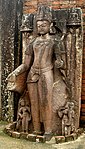
(List of monuments) -
[SL. No.]: N-OR-70
[Description]: Jagannath Temple
[Location]: Jajpur Town
[Address]: Dasaswamedha ghat, Jajapur Town
[District]: Jajpur
[Coordinates]:
[Image]: [[File:|150x150px|center|border|Jagannath Temple]]
(List of monuments) -
[SL. No.]: N-OR-71
[Description]: Trilochaneswar Temple
[Location]: Jajpur Town
[Address]: Near Biraja Temple, Jajapur Town
[District]: Jajpur
[Coordinates]:
[Image]: [[File:|150x150px|center|border|Trilochaneswar Temple]]
(List of monuments) -
[SL. No.]: N-OR-72
[Description]: Varahanatha Temple
[Location]: Jajpur Town
[Address]: Jajapur Town
[District]: Jajpur
[Coordinates]:
[Image]:
(List of monuments) -
[SL. No.]: N-OR-73
[Description]: Buddhist site (excavated)]]
[Location]: Udaigiri
[Address]: Ratnagiri Road, Udayagiri, Jajapur
[District]: Jajpur
[Coordinates]:
[Image]: [[File:]]|150x150px|center|border|Buddhist site (excavated)]]]]
(List of monuments) -
[SL. No.]: N-OR-74
[Description]: Ancient Buddhist Site, Langudi Hill
[Location]: Mauza Panimuhani, Fazilpur & Salipur,.
[Address]:
[District]: Jajpur
[Coordinates]:
[Image]:
(List of monuments) -
[SL. No.]: N-OR-75
[Description]: Kapileswar Mahadev Temple
[Location]: Hatuari
[Address]: Badasuanlo, Kamakhyanagar
[District]: Dhenkanal
[Coordinates]:
[Image]: [[File:|150x150px|center|border|Kapileswar Mahadev Temple]]
(List of monuments) -
[SL. No.]: N-OR-76
[Description]: Chandrasekhar Temple ( Group of Monuments and Ancient Steps )
[Location]: Yogapitha Kapilas
[Address]: Kapilas, Dhenkanal
[District]: Dhenkanal
[Coordinates]:
[Image]:
(List of monuments) -
[SL. No.]: N-OR-77
[Description]: Annakoteswar Temple
[Location]: Latadeipur
[Address]: Joranda Road, Latadeipur, Dhenkanal
[District]: Dhenkanal
[Coordinates]:
[Image]: [[File:|150x150px|center|border|Annakoteswar Temple]]
(List of monuments) -
[SL. No.]: N-OR-78
[Description]: Anantsayi Vishnu
[Location]: Sarang
[Address]: On the Bank of River Brahmani, Saranga
[District]: Dhenkanal
[Coordinates]:
[Image]:
(List of monuments)
New Random Display Display All Items(78)