


-
[NM#]: 334
[Monument name]: Aghaviller
[Description]: Church & Round Tower
[Image]:
[Townland]: Aghaviller
[Location]: 52°27′55″N 7°16′05″W / 52.465167°N 7.2679167°W / 52.465167; -7.2679167
(National Monuments) -
[NM#]: 599
[Monument name]: Ballyboodan Ogham Stone
[Description]: Ogham Stone (AD 700-900)
[Image]:
[Townland]: Ballyboodan
[Location]: 52°28′12″N 7°13′22″W / 52.4701036°N 7.2226583°W / 52.4701036; -7.2226583
(National Monuments) -
[NM#]: 282
[Monument name]: Ballylarkin Church
[Description]: Church
[Image]:
[Townland]: Ballylarkin Upper
[Location]: 52°43′22″N 7°25′39″W / 52.722866°N 7.427629°W / 52.722866; -7.427629
(National Monuments) -
[NM#]: 475
[Monument name]: Callan Augustinian Friary
[Description]: Friary (Augustinians)
[Image]:
[Townland]: Callan North
[Location]: 52°32′45″N 7°23′14″W / 52.545787°N 7.387348°W / 52.545787; -7.387348
(National Monuments) -
[NM#]: 455
[Monument name]: Callan Church (St. Mary's)
[Description]: Church
[Image]:
[Townland]: Callan South
[Location]: 52°32′39″N 7°23′25″W / 52.544064°N 7.39015°W / 52.544064; -7.39015
(National Monuments) -
[NM#]: 79
[Monument name]: Kilkieran High Crosses
[Description]: High Crosses
[Image]: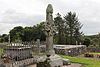
[Townland]: Castletown (Iverk barony)
[Location]: 52°23′52″N 7°22′51″W / 52.397809°N 7.380761°W / 52.397809; -7.380761
(National Monuments) -
[NM#]: 274
[Monument name]: Clara Castle
[Description]: Castle
[Image]:
[Townland]: Clara Upper
[Location]: 52°40′10″N 7°09′08″W / 52.669444°N 7.152168°W / 52.669444; -7.152168
(National Monuments) -
[NM#]: 77
[Monument name]: Clonamery Church
[Description]: Church
[Image]:
[Townland]: Clonamery
[Location]: 52°28′01″N 7°01′54″W / 52.466927°N 7.031789°W / 52.466927; -7.031789
(National Monuments) -
[NM#]: 646
[Monument name]: Coolhill Castle
[Description]: Donjon
[Image]:
[Townland]: Coolhill
[Location]: 52°27′54″N 6°55′56″W / 52.464942°N 6.932191°W / 52.464942; -6.932191
(National Monuments) -
[NM#]: 321
[Monument name]: Burnchurch Castle
[Description]: Castle & Tower
[Image]:
[Townland]: Farmley
[Location]: 52°34′34″N 7°17′51″W / 52.576039°N 7.297509°W / 52.576039; -7.297509
(National Monuments) -
[NM#]: 522
[Monument name]: Magdalan Castle
[Description]: Castle
[Image]:
[Townland]: GardensKilkenny City
[Location]: 52°39′10″N 7°14′41″W / 52.652673°N 7.244756°W / 52.652673; -7.244756
(National Monuments) -
[NM#]: 331, 344
[Monument name]: St. John's Abbey, Kilkenny
[Description]: Priory (Augustinian) (part of & chancel)
[Image]: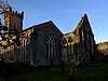
[Townland]: GardensKilkenny City
[Location]: 52°39′13″N 7°14′54″W / 52.653549°N 7.248406°W / 52.653549; -7.248406
(National Monuments) -
[NM#]: 626
[Monument name]: Kells Castle
[Description]: Motte & Bailey
[Image]:
[Townland]: Garrynamann LowerKells ,County Kilkenny
[Location]: 52°32′18″N 7°16′01″W / 52.538333°N 7.266944°W / 52.538333; -7.266944
(National Monuments) -
[NM#]: 214
[Monument name]: St. Mary's Collegiate Church Gowran
[Description]: Collegiate Church
[Image]: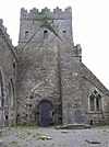
[Townland]: Gowran
[Location]: 52°37′45″N 7°03′48″W / 52.6292°N 7.0633°W / 52.6292; -7.0633
(National Monuments) -
[NM#]: 620
[Monument name]: Graiguenamanagh Abbey
[Description]: Abbey (Cistercians)
[Image]:
[Townland]: Graiguenamanagh
[Location]: 52°32′27″N 6°57′16″W / 52.54076°N 6.954525°W / 52.54076; -6.954525
(National Monuments) -
[NM#]: 74
[Monument name]: Grangefertagh
[Description]: Round Tower & Church
[Image]:
[Townland]: Grangefertagh
[Location]: 52°46′42″N 7°32′41″W / 52.77841°N 7.544691°W / 52.77841; -7.544691
(National Monuments) -
[NM#]: 80
[Monument name]: Jerpoint Abbey
[Description]: Abbey (Cistercian)
[Image]: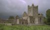
[Townland]: Jerpointabbey
[Location]: 52°30′39″N 7°09′28″W / 52.510713°N 7.157804°W / 52.510713; -7.157804
(National Monuments) -
[NM#]: 300
[Monument name]: Kilfane Church
[Description]: Church
[Image]: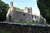
[Townland]: Kilfane Demesne
[Location]: 52°33′15″N 7°07′06″W / 52.554055°N 7.118406°W / 52.554055; -7.118406
(National Monuments) -
[NM#]: 75
[Monument name]: Killamery High Cross
[Description]: High Cross
[Image]:
[Townland]: Killamery
[Location]: 52°28′31″N 7°26′45″W / 52.475389°N 7.445971°W / 52.475389; -7.445971
(National Monuments) -
[NM#]: 324
[Monument name]: Kilmogue Portal Tomb
[Description]: Portal Tomb
[Image]:
[Townland]: Kilmogue, Harristown
[Location]: 52°24′11″N 7°15′45″W / 52.403077°N 7.2625°W / 52.403077; -7.2625
(National Monuments) -
[NM#]: 76
[Monument name]: Kilree
[Description]: Church, Round Tower & Cross
[Image]: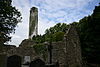
[Townland]: Kilree
[Location]: 52°31′05″N 7°16′07″W / 52.518108°N 7.268573°W / 52.518108; -7.268573
(National Monuments) -
[NM#]: 655
[Monument name]: Knockroe Passage Tomb
[Description]: Passage Tomb
[Image]:
[Townland]: Knockroe (Kells, Killamery)
[Location]: 52°25′54″N 7°23′59″W / 52.43175°N 7.39981°W / 52.43175; -7.39981
(National Monuments) -
[NM#]: 399
[Monument name]: Dunmore Cave
[Description]: Cave
[Image]:
[Townland]: Ballyfoyle
[Location]: 52°44′02″N 7°14′48″W / 52.733946°N 7.246579°W / 52.733946; -7.246579
(National Monuments) -
[NM#]: 180
[Monument name]: Kells Priory
[Description]: Priory (Augustinian)
[Image]: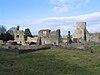
[Townland]: Rathduff (Madden)
[Location]: 52°32′19″N 7°16′01″W / 52.538632°N 7.266906°W / 52.538632; -7.266906
(National Monuments) -
[NM#]: 376
[Monument name]: Rathealy Ringfort
[Description]: Ringfort
[Image]:
[Townland]: Rathealy
[Location]: 52°41′41″N 7°25′57″W / 52.694722°N 7.432625°W / 52.694722; -7.432625
(National Monuments) -
[NM#]: 73
[Monument name]: Sheepstown Church
[Description]: Church
[Image]:
[Townland]: Sheepstown
[Location]: 52°29′06″N 7°14′36″W / 52.485080°N 7.243442°W / 52.485080; -7.243442
(National Monuments) -
[NM#]: 72
[Monument name]: St. Francis Abbey (Kilkenny)
[Description]: Friary (Franciscan)
[Image]:
[Townland]: St. Mary's Parish
[Location]: 52°39′21″N 7°15′12″W / 52.655926°N 7.253431°W / 52.655926; -7.253431
(National Monuments) -
[NM#]: 191
[Monument name]: Thomastown Church
[Description]: Church
[Image]:
[Townland]: Thomastown
[Location]: 52°31′33″N 7°08′22″W / 52.525937°N 7.139316°W / 52.525937; -7.139316
(National Monuments) -
[NM#]: 161
[Monument name]: Tullaherin
[Description]: Round Tower
[Image]:
[Townland]: Tullaherin
[Location]: 52°34′45″N 7°07′50″W / 52.579284°N 7.130428°W / 52.579284; -7.130428
(National Monuments) -
[NM#]: 670
[Monument name]: Tullaroan Church
[Description]: Church
[Image]:
[Townland]: Tullaroan
[Location]: 52°39′29″N 7°26′01″W / 52.658076°N 7.43363°W / 52.658076; -7.43363
(National Monuments) -
[NM#]: 78
[Monument name]: Ullard Church
[Description]: Church
[Image]:
[Townland]: Ullard
[Location]: 52°34′49″N 6°55′59″W / 52.580162°N 6.932934°W / 52.580162; -6.932934
(National Monuments) -
[NM#]: 372
[Monument name]: Callan Motte
[Description]: Motte
[Image]:
[Townland]: Westcourt Demesne
[Location]: 52°32′48″N 7°23′29″W / 52.546749°N 7.391368°W / 52.546749; -7.391368
(National Monuments)
New Random Display Display All Items(32)