


-
[SL. No.]: N-MH-A1
[Description]: Damri Masjid
[Location]: Ahmednagar
[Address]:
[District]: Ahmednagar
[Coordinates]:
[Image]: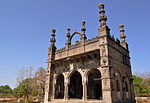
 More images
 -
[SL. No.]: N-MH-A2
[Description]: Gate near Niyamat Khan's Place
[Location]: Ahmednagar
[Address]:
[District]: Ahmednagar
[Coordinates]:
[Image]:
-
[SL. No.]: N-MH-A3
[Description]: Kotla of Twelve Imams
[Location]: Ahmednagar
[Address]:
[District]: Ahmednagar
[Coordinates]:
[Image]: More images
 -
[SL. No.]: N-MH-A4
[Description]: Mucca Masjid
[Location]: Ahmednagar
[Address]:
[District]: Ahmednagar
[Coordinates]:
[Image]: -
[SL. No.]: N-MH-A5
[Description]: Old tomb near Changiz Khan's palace
[Location]: Ahmednagar
[Address]:
[District]: Ahmednagar
[Coordinates]:
[Image]:
-
[SL. No.]: N-MH-A6
[Description]: Tomb of Nizam Ahmedshah
[Location]: Ahmednagar
[Address]:
[District]: Ahmednagar
[Coordinates]:
[Image]:
-
[SL. No.]: N-MH-A7
[Description]: Hemadpanthi Temple
[Location]: Bemini
[Address]:
[District]: Ahmednagar
[Coordinates]:
[Image]: -
[SL. No.]: N-MH-A8
[Description]: Dhokeshwar Caves
[Location]: Dhoke
[Address]:
[District]: Ahmednagar
[Coordinates]:
[Image]:
-
[SL. No.]: N-MH-A9
[Description]: Building Known as Faria Bagh
[Location]: Ghotan
[Address]:
[District]: Ahmednagar
[Coordinates]:
[Image]:
-
[SL. No.]: N-MH-A10
[Description]: Jain Temple
[Location]: Bhingar Cantonment
[Address]:
[District]: Ahmednagar
[Coordinates]:
[Image]: -
[SL. No.]: N-MH-A11
[Description]: Temple of Mallikarjuna
[Location]: Ghotan
[Address]:
[District]: Ahmednagar
[Coordinates]:
[Image]: -
[SL. No.]: N-MH-A12
[Description]: Cave & Temple
[Location]: Harishchandragad
[Address]:
[District]: Ahmednagar
[Coordinates]:
[Image]: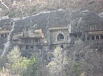 More images
 -
[SL. No.]: N-MH-A13
[Description]: Jarasangh Nagari
[Location]: Jorve
[Address]:
[District]: Ahmednagar
[Coordinates]:
[Image]: -
[SL. No.]: N-MH-A14
[Description]: Temple of Mallikarjuna
[Location]: Karjat
[Address]:
[District]: Ahmednagar
[Coordinates]:
[Image]: -
[SL. No.]: N-MH-A15
[Description]: Temple of Shiva called Naktichedeul
[Location]: Karjat
[Address]:
[District]: Ahmednagar
[Coordinates]:
[Image]: -
[SL. No.]: N-MH-A16
[Description]: Old Temple
[Location]: Kokamthan
[Address]:
[District]: Ahmednagar
[Coordinates]:
[Image]: -
[SL. No.]: N-MH-A17
[Description]: Temple of Devi
[Location]: Mandavagaon Katrabad
[Address]:
[District]: Ahmednagar
[Coordinates]:
[Image]: -
[SL. No.]: N-MH-A18
[Description]: Salbathan's Tomb
[Location]: Mohekari
[Address]:
[District]: Ahmednagar
[Coordinates]:
[Image]:
-
[SL. No.]: N-MH-A19
[Description]: Temple of Shiva on the further side of the stream
[Location]: Parner
[Address]:
[District]: Ahmednagar
[Coordinates]:
[Image]: -
[SL. No.]: N-MH-A20
[Description]: Baleshwar Temple
[Location]: Pedgaon
[Address]:
[District]: Ahmednagar
[Coordinates]:
[Image]:
-
[SL. No.]: N-MH-A21
[Description]: Temple of Laxmi Narayan
[Location]: Pedgaon
[Address]:
[District]: Ahmednagar
[Coordinates]:
[Image]:
-
[SL. No.]: N-MH-A22
[Description]: Temple of Amriteshwar
[Location]: Ratanwadi
[Address]:
[District]: Ahmednagar
[Coordinates]:
[Image]: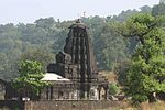 More images
 -
[SL. No.]: N-MH-A23
[Description]: Jagdamba mata mandir
[Location]: Tahakari Tal-Akole
[Address]: 422601
[District]: Ahmednagar
[Coordinates]:
[Image]:
-
[SL. No.]: N-MH-A24
[Description]: Five Stone Gates
[Location]: Tisgaon
[Address]:
[District]: Ahmednagar
[Coordinates]:
[Image]: -
[SL. No.]: N-MH-A25
[Description]: Temple of Devi
[Location]: Toka
[Address]:
[District]: Ahmednagar
[Coordinates]:
[Image]: -
[SL. No.]: N-MH-A26
[Description]: Temple of Siddheshwar Mahadev
[Location]: Toka
[Address]:
[District]: Ahmednagar
[Coordinates]:
[Image]:
-
[SL. No.]: N-MH-A27
[Description]: Temple of Vishnu & Five Ghats at attached thereto.
[Location]: Toka
[Address]:
[District]: Ahmednagar
[Coordinates]:
[Image]: -
[SL. No.]: N-MH-A28
[Description]: Ancient sites and remains at Daimabad
[Location]: Daimabad (Ladgaon)
[Address]:
[District]: Ahmednagar
[Coordinates]:
[Image]: -
[SL. No.]: N-MH-A29
[Description]: Ancient site locally known as Ladmod
[Location]: Newasa
[Address]:
[District]: Ahmednagar
[Coordinates]:
[Image]: -
[SL. No.]: N-MH-A30
[Description]: Dahihanda gate of outer city wall.
[Location]: Akola
[Address]:
[District]: Akola
[Coordinates]:
[Image]: -
[SL. No.]: N-MH-A31
[Description]: Khirki gate in the outer city wall
[Location]: Akola
[Address]:
[District]: Akola
[Coordinates]:
[Image]: -
[SL. No.]: N-MH-A32
[Description]: South -East bastion of the outer city wall together with 10 years of the adjacent wall on each side, variously known as panch Burj Hasrath Yab and containing a persion inscription.
[Location]: Akola
[Address]:
[District]: Akola
[Coordinates]:
[Image]: -
[SL. No.]: N-MH-A33
[Description]: Balapur fort
[Location]: Balapur
[Address]:
[District]: Akola
[Coordinates]:
[Image]:
-
[SL. No.]: N-MH-A34
[Description]: Chhatri near Dak Banglow
[Location]: Balapur
[Address]:
[District]: Akola
[Coordinates]:
[Image]: -
[SL. No.]: N-MH-A35
[Description]: Black stone temple of Bhawani
[Location]: Barsi Takil
[Address]:
[District]: Akola
[Coordinates]:
[Image]: -
[SL. No.]: N-MH-A36
[Description]: Narnala Fort :i Akot Gateway, ii Ambar Mahaliii Delhi Gateway, iv Large & Two smaller Gunsv Mahakali Gateway, vi Mendheao Gatewayvii Shahapur Gateway, viii Sirpur Gatewayix Small Mosque,x Tank buikt to contain Oil & Ghee.
[Location]: Patur
[Address]:
[District]: Akola
[Coordinates]:
[Image]: -
[SL. No.]: N-MH-A37
[Description]: Patur Cave (Two Cave)
[Location]: Patur
[Address]:
[District]: Akola
[Coordinates]: 20°27′57″N 76°56′01″E / 20.465938°N 76.933626°E / 20.465938; 76.933626 (SL. No. N-MH-A37)
[Image]: -
[SL. No.]: N-MH-A38
[Description]: Tank in front of tomb of Lalkhan
[Location]: Amner
[Address]:
[District]: Akola
[Coordinates]:
[Image]: -
[SL. No.]: N-MH-A39
[Description]: Tomb of Lalkhan
[Location]: Amner
[Address]:
[District]: Amaravati
[Coordinates]:
[Image]: -
[SL. No.]: N-MH-A40
[Description]: Gawilgarh Fort ( The walls & the whole area contained by them)
[Location]: Chikhaldara
[Address]:
[District]: Amaravati
[Coordinates]:
[Image]: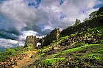 More images
 -
[SL. No.]: N-MH-A41
[Description]: City wall of Nawab Ismail Khan
[Location]: Bllichpur (Achalpur)
[Address]:
[District]: Amaravati
[Coordinates]:
[Image]: -
[SL. No.]: N-MH-A42
[Description]: Dula Gate
[Location]: Bllichpur (Achalpur)
[Address]:
[District]: Amaravati
[Coordinates]:
[Image]: -
[SL. No.]: N-MH-A43
[Description]: Haripura Gate
[Location]: Bllichpur (Achalpur)
[Address]:
[District]: Amaravati
[Coordinates]:
[Image]: -
[SL. No.]: N-MH-A44
[Description]: Hauz Katora
[Location]: Bllichpur (Achalpur)
[Address]:
[District]: Amaravati
[Coordinates]:
[Image]: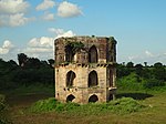 More images
 -
[SL. No.]: N-MH-A45
[Description]: Jiwanpura Gate
[Location]: Bllichpur (Achalpur)
[Address]:
[District]: Amaravati
[Coordinates]:
[Image]: -
[SL. No.]: N-MH-A46
[Description]: Temple of Anandeshwar
[Location]: Lasur
[Address]:
[District]: Amaravati
[Coordinates]:
[Image]: -
[SL. No.]: N-MH-A47
[Description]: Ajanta Caves
[Location]: Ajanta
[Address]:
[District]: Aurangabad
[Coordinates]: 20°33′09″N 75°42′02″E / 20.552377°N 75.700436°E / 20.552377; 75.700436 (SL. No. N-MH-A47)
[Image]: More images
 -
[SL. No.]: N-MH-A48
[Description]: Aurangabad Caves
[Location]: Aurangabad
[Address]:
[District]: Aurangabad
[Coordinates]: 19°55′01″N 75°18′43″E / 19.917°N 75.312°E / 19.917; 75.312 (SL. No. N-MH-A48)
[Image]:
-
[SL. No.]: N-MH-A49
[Description]: Tomb of Rabia Daurani (Bibi-Ka-Maqbara)
[Location]: Aurangabad
[Address]:
[District]: Aurangabad
[Coordinates]:
[Image]:
-
[SL. No.]: N-MH-A50
[Description]: Daulatabad Fort & Monument therein (i.e. Chand Minar)
[Location]: Daulatabad
[Address]:
[District]: Aurangabad
[Coordinates]: 19°56′34″N 75°12′47″E / 19.942724°N 75.213164°E / 19.942724; 75.213164 (SL. No. N-MH-A50)
[Image]: More images
 -
[SL. No.]: N-MH-A51
[Description]: Ellora Caves
[Location]: Ellora
[Address]:
[District]: Aurangabad
[Coordinates]: 20°01′35″N 75°10′45″E / 20.026389°N 75.179167°E / 20.026389; 75.179167 (SL. No. N-MH-A51)
[Image]: More images
 -
[SL. No.]: N-MH-A52
[Description]: Tomb of Aurangzeb
[Location]: Khuldabad
[Address]:
[District]: Aurangabad
[Coordinates]: 20°00′18″N 75°11′29″E / 20.005045°N 75.191398°E / 20.005045; 75.191398 (SL. No. N-MH-A52)
[Image]:
-
[SL. No.]: N-MH-A53
[Description]: Tomb of Malik Ambar
[Location]: Khuldabad
[Address]:
[District]: Aurangabad
[Coordinates]:
[Image]:
-
[SL. No.]: N-MH-A54
[Description]: Ancient Site / Mound
[Location]: Paithan
[Address]:
[District]: Aurangabad
[Coordinates]:
[Image]: -
[SL. No.]: N-MH-A55
[Description]: Pitalkhora Caves
[Location]: Paitalkhora
[Address]:
[District]: Aurangabad
[Coordinates]:
[Image]:
-
[SL. No.]: N-MH-A56
[Description]: Ghrishneshwar Temple, chattries & other ancient sites
[Location]: Verul (Ellora)
[Address]:
[District]: Aurangabad
[Coordinates]:
[Image]: More images
 -
[SL. No.]: N-MH-A57
[Description]: Area containing the old remains of two temples consisting of a collection of Massive stones in two separate heaps, One immediately outside padampur to the north & the other immediately to the south of Ganeshpur
[Location]: Padampur
[Address]:
[District]: Bhandara
[Coordinates]:
[Image]: -
[SL. No.]: N-MH-A58
[Description]: Remains of the temple to the North of the Village
[Location]: Padampur
[Address]:
[District]: Bhandara
[Coordinates]:
[Image]: -
[SL. No.]: N-MH-A59
[Description]: Remains of the temple to the North-west of the village
[Location]: Padampur
[Address]:
[District]: Bhandara
[Coordinates]:
[Image]: -
[SL. No.]: N-MH-A60
[Description]: Remains of the temple close to the south of the village Ganeshpur
[Location]: Padampur
[Address]:
[District]: Bhandara
[Coordinates]:
[Image]: -
[SL. No.]: N-MH-A61
[Description]: Remains of the temple locally known as Nath Bawa
[Location]: Padampur
[Address]:
[District]: Bhandara
[Coordinates]:
[Image]: -
[SL. No.]: N-MH-A62
[Description]: Valour Fort or Pratapgad
[Location]: Pratapgrah
[Address]:
[District]: Bhandara
[Coordinates]: 17°56′10″N 73°34′39″E / 17.936224°N 73.577607°E / 17.936224; 73.577607 (SL. No. N-MH-A62)
[Image]: More images
 -
[SL. No.]: N-MH-A63
[Description]: All the remains of the circumambulation wall of Pauni Fort
[Location]: Pauni
[Address]:
[District]: Bhandara
[Coordinates]:
[Image]: -
[SL. No.]: N-MH-A64
[Description]: Ancient mounds on which the modern temple of jagannath stands
[Location]: Pauni
[Address]:
[District]: Bhandara
[Coordinates]:
[Image]: -
[SL. No.]: N-MH-A65
[Description]: Mound known as Hardulala-ki-Tekri
[Location]: Pauni
[Address]:
[District]: Bhandara
[Coordinates]:
[Image]: -
[SL. No.]: N-MH-A66
[Description]: Cromlesh known as 'Tillota'(Frying Pan)
[Location]: Pipalgaon
[Address]:
[District]: Bhandara
[Coordinates]:
[Image]: -
[SL. No.]: N-MH-A67
[Description]: Ukkadeshwar Mahadev Temple
[Location]: Ukkad Pimpri
[Address]:
[District]: Beed
[Coordinates]:
[Image]: -
[SL. No.]: N-MH-A68
[Description]: Moti Samadhi
[Location]: Deulgaon Raja
[Address]:
[District]: Buldhana
[Coordinates]:
[Image]: -
[SL. No.]: N-MH-A69
[Description]: Three old Temples
[Location]: Dhotra
[Address]:
[District]: Buldhana
[Coordinates]:
[Image]: -
[SL. No.]: N-MH-A70
[Description]: Mosque
[Location]: Fathekherda (Sakharkheda)
[Address]:
[District]: Buldhana
[Coordinates]: 20°12′22″N 76°23′46″E / 20.2062°N 76.3962°E / 20.2062; 76.3962 (SL. No. N-MH-A70)
[Image]: -
[SL. No.]: N-MH-A71
[Description]: Two old Temple
[Location]: Kothali
[Address]:
[District]: Buldhana
[Coordinates]:
[Image]: -
[SL. No.]: N-MH-A72
[Description]: Dharmasala locally called chhatri
[Location]: Lonar
[Address]:
[District]: Buldhana
[Coordinates]:
[Image]: -
[SL. No.]: N-MH-A73
[Description]: Fifteen Temple
[Location]: Lonar
[Address]:
[District]: Buldhana
[Coordinates]:
[Image]: -
[SL. No.]: N-MH-A74
[Description]: Gaimukha Temple & Tank
[Location]: Lonar
[Address]:
[District]: Buldhana
[Coordinates]:
[Image]: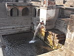
-
[SL. No.]: N-MH-A75
[Description]: Gaimukha Temple No 1 of Daitya Sudana
[Location]: Lonar
[Address]:
[District]: Buldhana
[Coordinates]:
[Image]: -
[SL. No.]: N-MH-A76
[Description]: Square Kunda on the East of the Town
[Location]: Lonar
[Address]:
[District]: Buldhana
[Coordinates]:
[Image]: -
[SL. No.]: N-MH-A77
[Description]: Temple of Daitya Sudana
[Location]: Lonar
[Address]:
[District]: Buldhana
[Coordinates]:
[Image]: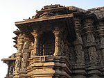 More images
 -
[SL. No.]: N-MH-A78
[Description]: Dharmasala at North-East corner of the town
[Location]: Mehkar
[Address]:
[District]: Buldhana
[Coordinates]:
[Image]: -
[SL. No.]: N-MH-A79
[Description]: Mosque
[Location]: Rohinkhed
[Address]:
[District]: Buldhana
[Coordinates]: 20°37′47″N 76°07′46″E / 20.629764°N 76.129444°E / 20.629764; 76.129444 (SL. No. N-MH-A79)
[Image]:
-
[SL. No.]: N-MH-A80
[Description]: Temple of Mahadev
[Location]: Sakegaon
[Address]:
[District]: Buldhana
[Coordinates]: 20°20′47″N 76°10′16″E / 20.346415°N 76.171069°E / 20.346415; 76.171069 (SL. No. N-MH-A80)
[Image]: -
[SL. No.]: N-MH-A81
[Description]: Temple of Vishnu, remains of an old building to the east of that temple and remains of small temple
[Location]: Satgaon
[Address]:
[District]: Buldhana
[Coordinates]:
[Image]: -
[SL. No.]: N-MH-A82
[Description]: Tank
[Location]: Sindhkhed Raja
[Address]:
[District]: Buldhana
[Coordinates]:
[Image]: -
[SL. No.]: N-MH-A83
[Description]: Temple of Mahadev
[Location]: Sindhkhed Raja
[Address]:
[District]: Buldhana
[Coordinates]:
[Image]: -
[SL. No.]: N-MH-A84
[Description]: Lakhuji Jadhavrao's Samadhi
[Location]: Sindhkhed
[Address]:
[District]: Buldhana
[Coordinates]:
[Image]: -
[SL. No.]: N-MH-A85
[Description]: Fort Wall
[Location]: Ballarpur
[Address]:
[District]: Chandrapur
[Coordinates]:
[Image]: -
[SL. No.]: N-MH-A86
[Description]: Fort
[Location]: Bhandak
[Address]:
[District]: Chandrapur
[Coordinates]:
[Image]: -
[SL. No.]: N-MH-A87
[Description]: Large high knoll immediately to the east of Bhandranath temple with remains of a temple, with huge stone carved blocks & a figure of Ganapati
[Location]: Bhandak
[Address]:
[District]: Chandrapur
[Coordinates]:
[Image]: -
[SL. No.]: N-MH-A88
[Description]: Vijasan Caves - Pandavas and Buddhist caves containing images and sculptures
[Location]: Bhandak
[Address]: Vijasan, Bhadravati
[District]: Chandrapur
[Coordinates]: 20°05′50″N 79°05′53″E / 20.097222°N 79.098056°E / 20.097222; 79.098056 (SL. No. N-MH-A88)
[Image]:
-
[SL. No.]: N-MH-A89
[Description]: Achaleshwar Temple & another small temple within an enclosure
[Location]: Chandrapur
[Address]:
[District]: Chandrapur
[Coordinates]: 19°56′46″N 79°18′11″E / 19.9460°N 79.3030°E / 19.9460; 79.3030 (SL. No. N-MH-A89)
[Image]: -
[SL. No.]: N-MH-A90
[Description]: Enclosure & buildings of the Gond Raja's Tomb just outside the Achaleshwar gate the city.
[Location]: Chandrapur
[Address]:
[District]: Chandrapur
[Coordinates]:
[Image]: -
[SL. No.]: N-MH-A91
[Description]: Fort Wall
[Location]: Chandrapur
[Address]:
[District]: Chandrapur
[Coordinates]: 19°56′40″N 79°18′05″E / 19.9444°N 79.3014°E / 19.9444; 79.3014 (SL. No. N-MH-A91)
[Image]:
-
[SL. No.]: N-MH-A92
[Description]: Lalpeth monoliths consisting of the sixteen colosal stone images.i. Anna Purna, ii. Bhim, iii. Fish, iv. Ganga v. Ganpati, vi. Hanuman,vii. Hanuman, viii. Kali, ix. Mahadev, x. Mahadev xi. Nandi, xii. Rawan,xiii. Snake, xiv. Tortoise xv. Ganpatixvi. Ganga
[Location]: Chandrapur
[Address]:
[District]: Chandrapur
[Coordinates]:
[Image]: -
[SL. No.]: N-MH-A93
[Description]: Mahadev Temple close to the Municipal office
[Location]: Chandrapur
[Address]:
[District]: Chandrapur
[Coordinates]:
[Image]: -
[SL. No.]: N-MH-A94
[Description]: Temple of the Mahakali
[Location]: Chandrapur
[Address]:
[District]: Chandrapur
[Coordinates]: 19°56′34″N 79°18′14″E / 19.9428°N 79.3040°E / 19.9428; 79.3040 (SL. No. N-MH-A94)
[Image]: -
[SL. No.]: N-MH-A95
[Description]: Temple of Keshavanath
[Location]: Churul
[Address]:
[District]: Chandrapur
[Coordinates]:
[Image]: -
[SL. No.]: N-MH-A96
[Description]: Ancient Temple
[Location]: Deotek
[Address]:
[District]: Chandrapur
[Coordinates]:
[Image]: -
[SL. No.]: N-MH-A97
[Description]: Hemadpanthi Temple containing images of Dattatraya, Mahadev & Laxminarayan
[Location]: Dhanora
[Address]:
[District]: Chandrapur
[Coordinates]:
[Image]: -
[SL. No.]: N-MH-A98
[Description]: Old Bridge
[Location]: Ghutkala
[Address]:
[District]: Chandrapur
[Coordinates]:
[Image]: -
[SL. No.]: N-MH-A99
[Description]: Old Temple of Chandikadevi
[Location]: Ghutkala
[Address]:
[District]: Chandrapur
[Coordinates]:
[Image]: -
[SL. No.]: N-MH-A100
[Description]: Remains of an old Fort
[Location]: Khatora
[Address]:
[District]: Chandrapur
[Coordinates]:
[Image]: -
[SL. No.]: N-MH-A101
[Description]: Temple of Mahadev
[Location]: Mahadwari
[Address]:
[District]: Chandrapur
[Coordinates]:
[Image]: -
[SL. No.]: N-MH-A102
[Description]: Temple of Mahadev
[Location]: Neri
[Address]:
[District]: Chandrapur
[Coordinates]:
[Image]: -
[SL. No.]: N-MH-A103
[Description]: Ramdigi temple & Ramdigi pool
[Location]: Nimdhela Forest
[Address]:
[District]: Chandrapur
[Coordinates]:
[Image]: -
[SL. No.]: N-MH-A104
[Description]: Old Hemadpanthi Temple
[Location]: Palebaras
[Address]:
[District]: Chandrapur
[Coordinates]:
[Image]: -
[SL. No.]: N-MH-A105
[Description]: Old Temple of Mahadev
[Location]: Rajgarh
[Address]:
[District]: Chandrapur
[Coordinates]:
[Image]: -
[SL. No.]: N-MH-A106
[Description]: Math
[Location]: Balsana
[Address]:
[District]: Dhulia
[Coordinates]:
[Image]: -
[SL. No.]: N-MH-A107
[Description]: Small Temple on Survey No.141
[Location]: Balsana
[Address]:
[District]: Dhulia
[Coordinates]:
[Image]: -
[SL. No.]: N-MH-A108
[Description]: Temple of Durga
[Location]: Balsana
[Address]:
[District]: Dhulia
[Coordinates]:
[Image]: -
[SL. No.]: N-MH-A109
[Description]: Temple of Shiva
[Location]: Balsana
[Address]:
[District]: Dhulia
[Coordinates]:
[Image]: -
[SL. No.]: N-MH-A110
[Description]: Temple of the left side of shiva's Temple in Survey No. 418
[Location]: Balsana
[Address]:
[District]: Dhulia
[Coordinates]:
[Image]: -
[SL. No.]: N-MH-A111
[Description]: Temple in front of the above in Survey No. 418
[Location]: Balsana
[Address]:
[District]: Dhulia
[Coordinates]:
[Image]: -
[SL. No.]: N-MH-A112
[Description]: Temple between Durga's Temple and Math in Survey No. 141
[Location]: Balsana
[Address]:
[District]: Dhulia
[Coordinates]:
[Image]: -
[SL. No.]: N-MH-A113
[Description]: Old gateways in the ruined fort & caves
[Location]: Bhamer
[Address]:
[District]: Dhulia
[Coordinates]:
[Image]: -
[SL. No.]: N-MH-A114
[Description]: Seven Mohammedan Tombs
[Location]: Thalner
[Address]:
[District]: Dhulia
[Coordinates]:
[Image]: -
[SL. No.]: N-MH-A115
[Description]: Three Mohammedan Tombs
[Location]: Thalner
[Address]:
[District]: Dhulia
[Coordinates]:
[Image]: -
[SL. No.]: N-MH-A116
[Description]: Ancient site & remains
[Location]: Prakasha
[Address]:
[District]: Dhulia
[Coordinates]:
[Image]: -
[SL. No.]: N-MH-A117
[Description]: Old Temple
[Location]: Armori
[Address]:
[District]: Gadchiroli
[Coordinates]:
[Image]: -
[SL. No.]: N-MH-A118
[Description]: Stone Circle
[Location]: Arsoda
[Address]:
[District]: Gadchiroli
[Coordinates]:
[Image]: -
[SL. No.]: N-MH-A119
[Description]: Group of twenty cromlechs or Kistvaens
[Location]: Chamurshi
[Address]:
[District]: Gadchiroli
[Coordinates]:
[Image]: -
[SL. No.]: N-MH-A120
[Description]: Rock Caves
[Location]: Jharapapra
[Address]:
[District]: Gadchiroli
[Coordinates]:
[Image]: -
[SL. No.]: N-MH-A121
[Description]: Group of Temples
[Location]: Markanda
[Address]:
[District]: Gadchiroli
[Coordinates]: 19°59′40″N 79°51′59″E / 19.9944°N 79.8664°E / 19.9944; 79.8664 (SL. No. N-MH-A121)
[Image]:
-
[SL. No.]: N-MH-A122
[Description]: Fortress of Tipagarh
[Location]: Murumgaon
[Address]:
[District]: Gadchiroli
[Coordinates]:
[Image]: -
[SL. No.]: N-MH-A123
[Description]: Large Temple
[Location]: Thanegaon
[Address]:
[District]: Gadchiroli
[Coordinates]:
[Image]: -
[SL. No.]: N-MH-A124
[Description]: Fort wall
[Location]: Waira
[Address]:
[District]: Gadchiroli
[Coordinates]: 20°25′54″N 80°05′33″E / 20.4316°N 80.0926°E / 20.4316; 80.0926 (SL. No. N-MH-A124)
[Image]: -
[SL. No.]: N-MH-A125
[Description]: Temple of Bhandareshwar
[Location]: Waira
[Address]:
[District]: Gadchiroli
[Coordinates]: 20°25′34″N 80°05′06″E / 20.4260°N 80.0851°E / 20.4260; 80.0851 (SL. No. N-MH-A125)
[Image]: -
[SL. No.]: N-MH-A126
[Description]: Ancient mound & monument known as Pawar's Gadhi
[Location]: Bahal
[Address]:
[District]: Jalgaon
[Coordinates]:
[Image]: -
[SL. No.]: N-MH-A127
[Description]: Temple of Changdev
[Location]: Changdev
[Address]:
[District]: Jalgaon
[Coordinates]:
[Image]: -
[SL. No.]: N-MH-A128
[Description]: Temple of Debi & Sambha
[Location]: Dighi
[Address]:
[District]: Jalgaon
[Coordinates]:
[Image]: -
[SL. No.]: N-MH-A129
[Description]: Maheswara Temple
[Location]: Patan
[Address]:
[District]: Jalgaon
[Coordinates]:
[Image]: More images
 -
[SL. No.]: N-MH-A130
[Description]: Temple of Chandika Devi
[Location]: Patan
[Address]:
[District]: Jalgaon
[Coordinates]:
[Image]: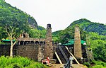 More images
 -
[SL. No.]: N-MH-A131
[Description]: Temple of Nagarjun
[Location]: Patan
[Address]:
[District]: Jalgaon
[Coordinates]:
[Image]: -
[SL. No.]: N-MH-A132
[Description]: Temple of Shringer Chavdi
[Location]: Patan
[Address]:
[District]: Jalgaon
[Coordinates]:
[Image]: -
[SL. No.]: N-MH-A133
[Description]: Mahadev Temple
[Location]: Sangameshwar
[Address]:
[District]: Jalgaon
[Coordinates]:
[Image]: -
[SL. No.]: N-MH-A134
[Description]: Mudhai Devi Temple
[Location]: Vaghli
[Address]:
[District]: Jalgaon
[Coordinates]:
[Image]: -
[SL. No.]: N-MH-A135
[Description]: Old Temple of Siddheshwar with three inscriptions slabs
[Location]: Vaghli
[Address]:
[District]: Jalgaon
[Coordinates]:
[Image]: -
[SL. No.]: N-MH-A136
[Description]: Ancient site and remains
[Location]: Tekwada
[Address]:
[District]: Jalgaon
[Coordinates]:
[Image]: -
[SL. No.]: N-MH-A137
[Description]: Archaeological site & remains
[Location]: Bhokardan
[Address]:
[District]: Jalna
[Coordinates]:
[Image]: -
[SL. No.]: N-MH-A138
[Description]: Remains of an old fort on the hill
[Location]: Bhiwagarh
[Address]:
[District]: Nagpur
[Coordinates]:
[Image]: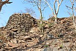
-
[SL. No.]: N-MH-A139
[Description]: Fort
[Location]: Dpnagartal
[Address]:
[District]: Nagpur
[Coordinates]:
[Image]:
-
[SL. No.]: N-MH-A140
[Description]: Temple of Mahadev
[Location]: Ghogra
[Address]:
[District]: Nagpur
[Coordinates]:
[Image]: -
[SL. No.]: N-MH-A141
[Description]: Stone Circle
[Location]: Junapani
[Address]: Near Fetari, down MH SH 248.
[District]: Nagpur
[Coordinates]: 21°11′49″N 78°59′56″E / 21.196916°N 78.998911°E / 21.196916; 78.998911 (SL. No. N-MH-A141)
[Image]: More images
 -
[SL. No.]: N-MH-A142
[Description]: Stone Circle
[Location]: Ghorar
[Address]:
[District]: Nagpur
[Coordinates]:
[Image]: -
[SL. No.]: N-MH-A143
[Description]: Ancient Buddhist remains comprising monastery, stupas, Rock-cut inscription etc.
[Location]: Mansar & Kahari
[Address]:
[District]: Nagpur
[Coordinates]:
[Image]: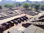
-
[SL. No.]: N-MH-A144
[Description]: Stone circle
[Location]: Nildho
[Address]:
[District]: Nagpur
[Coordinates]:
[Image]: -
[SL. No.]: N-MH-A145
[Description]: Kalimata's Temple
[Location]: Ramtek
[Address]:
[District]: Nagpur
[Coordinates]:
[Image]:
-
[SL. No.]: N-MH-A146
[Description]: Remains of a very old shrines upon the western ride at the end of the Remtek hill consisting of a portion of porch of a temple and the mutilated image of Trivikram Avatara of Vishnu
[Location]: Ramtek
[Address]:
[District]: Nagpur
[Coordinates]:
[Image]:
-
[SL. No.]: N-MH-A147
[Description]: Tank and Mandapa opposite to the Dattatraya's Temple
[Location]: Ramtek
[Address]:
[District]: Nagpur
[Coordinates]:
[Image]:
-
[SL. No.]: N-MH-A148
[Description]: Stone Circle
[Location]: Takalghat
[Address]:
[District]: Nagpur
[Coordinates]:
[Image]: -
[SL. No.]: N-MH-A149
[Description]: Brahmanical caves known as a Pandevlena or Pandav Leni.
[Location]: Mahoor village
[Address]:
[District]: Nanded
[Coordinates]:
[Image]: -
[SL. No.]: N-MH-A150
[Description]: Hindu Temple
[Location]: Ambegaon
[Address]:
[District]: Nasik
[Coordinates]:
[Image]:
-
[SL. No.]: N-MH-A151
[Description]: Old Temple
[Location]: Anjaneri
[Address]:
[District]: Nasik
[Coordinates]:
[Image]:
-
[SL. No.]: N-MH-A152
[Description]: Caves
[Location]: Ankai
[Address]:
[District]: Nasik
[Coordinates]:
[Image]: -
[SL. No.]: N-MH-A153
[Description]: Hindu Temple
[Location]: Deothan
[Address]:
[District]: Nasik
[Coordinates]:
[Image]:
-
[SL. No.]: N-MH-A154
[Description]: Old Matichi-Gadhi
[Location]: Nasik
[Address]:
[District]: Nasik
[Coordinates]:
[Image]: -
[SL. No.]: N-MH-A155
[Description]: Pandev Lena Caves
[Location]: Pathardi
[Address]:
[District]: Nasik
[Coordinates]:
[Image]: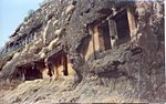
-
[SL. No.]: N-MH-A156
[Description]: Temple of Aeshwar
[Location]: Sinnar
[Address]:
[District]: Nasik
[Coordinates]:
[Image]: -
[SL. No.]: N-MH-A157
[Description]: Temple of Gondeshwar Mahadev
[Location]: Sinnar
[Address]:
[District]: Nasik
[Coordinates]:
[Image]: More images
 -
[SL. No.]: N-MH-A158
[Description]: Trimbakeshwar Temple
[Location]: Tringalwadi
[Address]:
[District]: Nasik
[Coordinates]:
[Image]:
-
[SL. No.]: N-MH-A159
[Description]: Jain Temple
[Location]: Tringalwadi
[Address]:
[District]: Nasik
[Coordinates]:
[Image]: -
[SL. No.]: N-MH-A160
[Description]: Hemadpanthi Temple of Mahadev
[Location]: Zodge
[Address]:
[District]: Nasik
[Coordinates]:
[Image]: -
[SL. No.]: N-MH-A161
[Description]: Fort
[Location]: Paunar
[Address]:
[District]: Wardha
[Coordinates]:
[Image]:
-
[SL. No.]: N-MH-A162
[Description]: Hemadapanthi Temple of Mahadev
[Location]: NNeir
[Address]:
[District]: Yeotmal
[Coordinates]:
[Image]: -
[SL. No.]: N-MH-A163
[Description]: Temple of Goddess pandardevi
[Location]: Pandhardevi
[Address]:
[District]: Yeotmal
[Coordinates]:
[Image]: -
[SL. No.]: N-MH-A164
[Description]: Temple of Kamaleshwar
[Location]: Pathrot
[Address]:
[District]: Yeotmal
[Coordinates]:
[Image]: -
[SL. No.]: N-MH-A165
[Description]: Mahadev Temple
[Location]: Rant Swangi
[Address]:
[District]: Yeotmal
[Coordinates]:
[Image]: -
[SL. No.]: N-MH-A166
[Description]: Mahadev Temple
[Location]: Rui-Wai
[Address]:
[District]: Yeotmal
[Coordinates]:
[Image]: -
[SL. No.]: N-MH-A167
[Description]: Hemadpanthi Temple of Shree Mahadev( Taponeshwar )
[Location]: Tapona
[Address]:
[District]: Yeotmal
[Coordinates]:
[Image]: -
[SL. No.]: N-MH-A168
[Description]: Mahadev Temple
[Location]: Yelabara
[Address]:
[District]: Yeotmal
[Coordinates]:
[Image]:
New Random Display Display All Items(168)