


-
[US#]: 44
[NJ#]: 1
[Image]: -
[Tower Name]: Culvers Station(previously Normanook Fire Tower)
[Elevation]: 1,509 feet (460 m)
[Height]: 47 feet (14 m)
[NJFFS DivisionSections covered]: Div. A Sec. A1 (PA,NY)
[Location of tower]: Stokes State Forest, Sandyston Township41°11′16.2″N 74°45′59.28″W / 41.187833°N 74.7664667°W / 41.187833; -74.7664667
[County]: Sussex
[Notes]:
(List of fire towers()) -
[US#]: 45
[NJ#]: 2
[Image]: -
[Tower Name]: Ramapo Station(previously Wind-beam Lookout)
[Elevation]: 1,011 feet (308 m)
[Height]: 50 feet (15 m)
[NJFFS DivisionSections covered]: Div. ASec. A2 (A5&NY)
[Location of tower]: Ramapo Mountain State ForestN41°03.521' W074°15.330'
[County]: Passaic
[Notes]:
(List of fire towers()) -
[US#]: 244
[NJ#]: 6
[Image]:
[Tower Name]: Bearfort Station
[Elevation]: 1,331 feet (406 m)
[Height]: 68 feet (21 m)
[NJFFS DivisionSections covered]: Div. ASec. A2, A5 (A1)
[Location of tower]: Bearfort MountainWest Milford TownshipN41°06.254' W074°25.044'
[County]: Passaic
[Notes]:
(List of fire towers()) -
[US#]: 246
[NJ#]: 8
[Image]: -
[Tower Name]: Budd Lake Station(previously 95 Mile Tree Lookout)
[Elevation]: 1,182 feet (360 m)
[Height]: 60 feet (18 m)
[NJFFS DivisionSections covered]: Div. A Sec. A6,A3,(A4,A8,A7)
[Location of tower]: Mount Olive TownshipN40°53.704' W074°45.026'
[County]: Morris
[Notes]:
(List of fire towers()) -
[US#]: 247
[NJ#]: 9
[Image]:
[Tower Name]: Catfish Station
[Elevation]: 1,555 feet (474 m)
[Height]: 60 feet (18 m)
[NJFFS DivisionSections covered]: Div. ASec. A3 (A6,PA)
[Location of tower]: Delaware Water Gap National Recreation Areanear BlairstownN41°02.855' W074°58.347'
[County]: Warren
[Notes]:
(List of fire towers()) -
[US#]: 553
[NJ#]: 12
[Image]: -
[Tower Name]: Greystone Station
[Elevation]: 909 feet (277 m)
[Height]: 92 feet (28 m)
[NJFFS DivisionSections covered]: Div. ASec. A7 A8,(A5,B10)
[Location of tower]: Union Hill, DenvilleN40°51.341' W074°30.690'
[County]: Morris
[Notes]:
(List of fire towers()) -
[US#]: 563
[NJ#]: 16
[Image]: -
[Tower Name]: Milton Station
[Elevation]: 1,341 feet (409 m)
[Height]: 80 feet (24 m)
[NJFFS DivisionSections covered]: Div. ASec. A4(A5)
[Location of tower]: Morris County ParkJefferson TownshipN41°00.520' W074°32.433'
[County]: Morris
[Notes]:
(List of fire towers()) -
[US#]: 243
[NJ#]: 5
[Image]: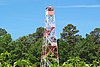
[Tower Name]: Bass River Station
[Elevation]: 47 feet (14 m)
[Height]: 80 feet (24 m)
[NJFFS DivisionSections covered]: Div. BSec. B4,B2,C7
[Location of tower]: Bass River State ForestN39°36.694' W074°26.197'
[County]: Burlington
[Notes]:
(List of fire towers()) -
[US#]: 564
[NJ#]: 17
[Image]:
[Tower Name]: Apple Pie Hill Station
[Elevation]: 179 feet (55 m)
[Height]: 60 feet (18 m)
[NJFFS DivisionSections covered]: Div. BSec. B1,B2,B3
[Location of tower]: Tabernacle TownshipN39°48.443' W074°35.363'
[County]: Burlington
[Notes]:
(List of fire towers()) -
[US#]: 565
[NJ#]: 18
[Image]: -
[Tower Name]: Batsto Station
[Elevation]: 70 feet (21 m)
[Height]: 100 feet (30 m)
[NJFFS DivisionSections covered]: Div. BSec. B2(B4,C8,C6)
[Location of tower]: Wharton State ForestN39°38.976' W074°38.567'
[County]: Burlington
[Notes]:
(List of fire towers()) -
[US#]: 248
[NJ#]: 10
[Image]: -
[Tower Name]: Cedar Bridge Station
[Elevation]: 204 feet (62 m)
[Height]: 100 feet (30 m)
[NJFFS DivisionSections covered]: Div. BSec. B7,B5,B4,B2
[Location of tower]: Lacey TownshipN39°50.380' W074°22.836'
[County]: Ocean
[Notes]:
(List of fire towers()) -
[US#]: 554
[NJ#]: 13
[Image]: -
[Tower Name]: Jamesburg Station(previously Old Bridge Fire Tower)
[Elevation]: 48 feet (15 m)
[Height]: 60 feet (18 m)
[NJFFS DivisionSections covered]: Div. BSec. B10,A7 (B9,A8)
[Location of tower]: Thompson County ParkMonroe TownshipN40°20.233' W074°26.318'
[County]: Middlesex
[Notes]:
(List of fire towers()) -
[US#]: 555
[NJ#]: 14
[Image]: -
[Tower Name]: Lakewood Station
[Elevation]: 136 feet (41 m)
[Height]: 80 feet (24 m)
[NJFFS DivisionSections covered]: Div. B Sec. B7,B8,B9(B5,B6,B10)
[Location of tower]: LakewoodN40°04.234' W074°13.674'
[County]: Ocean
[Notes]:
(List of fire towers()) -
[US#]: 556
[NJ#]: 15
[Image]: -
[Tower Name]: Lebanon Station
[Elevation]: 136 feet (41 m)
[Height]: 80 feet (24 m)
[NJFFS DivisionSections covered]: Div. BSec. B3,B6,(B5,B2)
[Location of tower]: Brendan T. Byrne State ForestN39°53.531' W074°34.880'
[County]: Burlington
[Notes]:
(List of fire towers()) -
[US#]: 568
[NJ#]: 21
[Image]: -
[Tower Name]: Medford Station
[Elevation]: 141 feet (43 m)
[Height]: 100 feet (30 m)
[NJFFS DivisionSections covered]: Div. BSec. B1,B3(B2,C11)
[Location of tower]: Piper's Corner, Medford TownshipN39°50.504' W074°47.375'
[County]: Burlington
[Notes]:
(List of fire towers()) -
[US#]: 245
[NJ#]: 7
[Image]: -
[Tower Name]: Belleplain Station
[Elevation]: 56 feet (17 m)
[Height]: 100 feet (30 m)
[NJFFS DivisionSections covered]: Div. CSec. C2(C4,C5,C6)
[Location of tower]: Belleplain State Forestnear WoodbineN39°17.036' W074°50.948'
[County]: Cape May
[Notes]:
(List of fire towers()) -
[US#]: 249
[NJ#]: 11
[Image]: -
[Tower Name]: McKeetown Station
[Elevation]: 75 feet (23 m)
[Height]: 100 feet (30 m)
[NJFFS DivisionSections covered]: Div. CSec. C6,C7,(C4,C5)
[Location of tower]: Egg Harbor TownshipN39°26.304' W074°37.039'
[County]: Atlantic
[Notes]:
(List of fire towers()) -
[US#]: 566
[NJ#]: 19
[Image]: -
[Tower Name]: Blue Anchor Station
[Elevation]: 152 feet (46 m)
[Height]: 86 feet (26 m)
[NJFFS DivisionSections covered]: Div. CSec. C11,C6,C9
[Location of tower]: Winslow TownshipN39°40.978' W074°53.348'
[County]: Camden
[Notes]:
(List of fire towers()) -
[US#]: 567
[NJ#]: 20
[Image]: -
[Tower Name]: Dias Creek Station
[Elevation]: 13 feet (4.0 m)
[Height]: 100 feet (30 m)
[NJFFS DivisionSections covered]: Div. CSec. C1,C2
[Location of tower]: Middle TownshipN39°06.271' W074°52.699'
[County]: Cape May
[Notes]:
(List of fire towers()) -
[US#]: 569
[NJ#]: 22
[Image]: -
[Tower Name]: Millville Station
[Elevation]: 83 feet (25 m)
[Height]: 100 feet (30 m)
[NJFFS DivisionSections covered]: Div. CSec. C3,C10,(C9)
[Location of tower]: MillvilleN39°23.939' W075°04.436'
[County]: Cumberland
[Notes]:
(List of fire towers()) -
[US#]: 570
[NJ#]: 23
[Image]: -
[Tower Name]: Mizpah Station
[Elevation]: 106 feet (32 m)
[Height]: 100 feet (30 m)
[NJFFS DivisionSections covered]: Div. CSec. C4,C5,(C9)
[Location of tower]: Mizpah, Hamilton TownshipN39°28.989' W074°50.851'
[County]: Atlantic
[Notes]:
(List of fire towers()) -
[US#]: 79
[NJ#]: 3
[Image]:
[Tower Name]: Batsto Mansion House Station(also known as Batsto Manor House Station)
[Elevation]: 72 feet (22 m)
[Height]: -
[NJFFS DivisionSections covered]: Div. B
[Location of tower]: Batsto Village State Historic SiteN39°38.604' W074°38.893'
[County]: Burlington
[Notes]:
(List of fire towers()) -
[US#]: 83
[NJ#]: 4
[Image]:
[Tower Name]: Green Pond Mountain Lookout(or Picatinny Arsenal Tower)
[Elevation]: 1,240 feet (380 m)
[Height]: -
[NJFFS DivisionSections covered]: Div. A
[Location of tower]: Picatinny ArsenalJefferson TownshipN40°57.003' W074°34.132'
[County]: Morris
[Notes]:
(List of fire towers())
New Random Display Display All Items(23)