


-
[US#]: 44
[NJ#]: 1
[Image]: -
[Tower Name]: Culvers Station(previously Normanook Fire Tower)
[Elevation]: 1,509 feet (460 m)
[Height]: 47 feet (14 m)
[NJFFS DivisionSections covered]: Div. A Sec. A1 (PA,NY)
[Location of tower]: Stokes State Forest, Sandyston Township41°11′16.2″N 74°45′59.28″W / 41.187833°N 74.7664667°W / 41.187833; -74.7664667
[County]: Sussex
[Notes]:
(List of fire towers()) -
[US#]: 243
[NJ#]: 5
[Image]: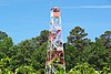
[Tower Name]: Bass River Station
[Elevation]: 47 feet (14 m)
[Height]: 80 feet (24 m)
[NJFFS DivisionSections covered]: Div. BSec. B4,B2,C7
[Location of tower]: Bass River State ForestN39°36.694' W074°26.197'
[County]: Burlington
[Notes]:
(List of fire towers()) -
[US#]: 569
[NJ#]: 22
[Image]: -
[Tower Name]: Millville Station
[Elevation]: 83 feet (25 m)
[Height]: 100 feet (30 m)
[NJFFS DivisionSections covered]: Div. CSec. C3,C10,(C9)
[Location of tower]: MillvilleN39°23.939' W075°04.436'
[County]: Cumberland
[Notes]:
(List of fire towers()) -
[US#]: 249
[NJ#]: 11
[Image]: -
[Tower Name]: McKeetown Station
[Elevation]: 75 feet (23 m)
[Height]: 100 feet (30 m)
[NJFFS DivisionSections covered]: Div. CSec. C6,C7,(C4,C5)
[Location of tower]: Egg Harbor TownshipN39°26.304' W074°37.039'
[County]: Atlantic
[Notes]:
(List of fire towers()) -
[US#]: 79
[NJ#]: 3
[Image]:
[Tower Name]: Batsto Mansion House Station(also known as Batsto Manor House Station)
[Elevation]: 72 feet (22 m)
[Height]: -
[NJFFS DivisionSections covered]: Div. B
[Location of tower]: Batsto Village State Historic SiteN39°38.604' W074°38.893'
[County]: Burlington
[Notes]:
(List of fire towers()) -
[US#]: 244
[NJ#]: 6
[Image]:
[Tower Name]: Bearfort Station
[Elevation]: 1,331 feet (406 m)
[Height]: 68 feet (21 m)
[NJFFS DivisionSections covered]: Div. ASec. A2, A5 (A1)
[Location of tower]: Bearfort MountainWest Milford TownshipN41°06.254' W074°25.044'
[County]: Passaic
[Notes]:
(List of fire towers())
New Random Display Display All Items(23)