


-
[Site]: 57-63 St. Louis Street

[Date(s)]: 1705-1811 (period of construction)
[Designated]: 1969
[Location]: Quebec City46°48′39.35″N 71°12′30.53″W / 46.8109306°N 71.2084806°W / 46.8109306; -71.2084806 (57-63 St. Louis Street)
[Description]: Three early eighteenth and nineteenth century stone houses within the walls of Quebec City’s Upper Town at the foot of Cavelier du Moulin Park; a notable grouping of buildings from the French Regime
[Image]:
(National Historic Sites) -
[Site]: Bélanger-Girardin House
[Date(s)]: 1735 (completed)
[Designated]: 1982
[Location]: Beauport46°51′33.32″N 71°11′31.09″W / 46.8592556°N 71.1919694°W / 46.8592556; -71.1919694 (Bélanger-Girardin House)
[Description]: A one-and-a-half-storey stone house with a steep roof located in Beauport, one of the first seigneuries of New France; one of the few remaining early French Regime houses erected in the (then) countryside near Quebec City
[Image]:
(National Historic Sites) -
[Site]: Beth Israël Cemetery
[Date(s)]: 1840-58 (acquisition of land)
[Designated]: 1992
[Location]: Quebec City46°47′4.15″N 71°15′34.79″W / 46.7844861°N 71.2596639°W / 46.7844861; -71.2596639 (Beth Israël Cemetery)
[Description]: Since the 19th century, most members of Quebec City's Jewish community have been interred in this cemetery; its age, burial house, linear spatial arrangement, grave marker designs and symbols make it an excellent representative example of a burial ground in the Jewish cultural tradition
[Image]:
(National Historic Sites) -
[Site]: Bon-Pasteur Chapel
[Date(s)]: 1868 (completed)
[Designated]: 1975
[Location]: Quebec City46°48′26.49″N 71°13′4.48″W / 46.8073583°N 71.2179111°W / 46.8073583; -71.2179111 (Bon-Pasteur Chapel)
[Description]: A rectangular five-storey stone-faced chapel with a gable roof that is part of the motherhouse of the Sisters of the Good Shepherd; it is prized for its interior designed by Charles Baillargé and is recognized as an outstanding example of religious architecture in Quebec
[Image]: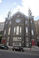
(National Historic Sites) -
[Site]: Capitol Theatre / Quebec Auditorium
[Date(s)]: 1903 (completed)
[Designated]: 1986
[Location]: Quebec City46°48′46.24″N 71°12′50.06″W / 46.8128444°N 71.2139056°W / 46.8128444; -71.2139056 (Capitol Theatre / Quebec Auditorium)
[Description]: Remarkable Beaux Arts-style theatre with a bombé (rounded) facade; evocative of the exuberance of Belle Époque theatres
[Image]:
(National Historic Sites) -
[Site]: Cartier-Brébeuf
[Date(s)]: 1535-6 (Cartier's wintering site)
[Designated]: 1958
[Location]: Quebec City46°49′31.01″N 71°14′22.7″W / 46.8252806°N 71.239639°W / 46.8252806; -71.239639 (Cartier-Brébeuf)
[Description]: A 6.8-hectare (17-acre) park located on the Saint-Charles River, near the former site of the Iroquoian village of Stadacona; commemorates the winter quarters of Jacques Cartier in 1535-1536, and the first residence of Jesuit missionaries in Quebec constructed in 1625-1626
[Image]:
(National Historic Sites) -
[Site]: Château Frontenac
[Date(s)]: 1893 (first phase completed)
[Designated]: 1981
[Location]: Quebec City46°48′42.99″N 71°12′17.76″W / 46.8119417°N 71.2049333°W / 46.8119417; -71.2049333 (Château Frontenac)
[Description]: An imposing hotel located prominently on a cliff overlooking the Saint Lawrence River; the first of a series of Chateau-style hotels constructed by railway companies in Canada in the late 19th and early 20th centuries to encourage railway travel, and the prototype for the railway hotels that followed
[Image]:
(National Historic Sites) -
[Site]: Charlesbourg-Royal
[Date(s)]: 1541 (established)
[Designated]: 1923
[Location]: Cap-Rouge46°44′53.35″N 71°20′29.72″W / 46.7481528°N 71.3415889°W / 46.7481528; -71.3415889 (Fort Charlesbourg Royal)
[Description]: The former site of two sixteenth-century forts established in 1541 by Jacques Cartier and abandoned in 1543; the first French colony in North America
[Image]:
(National Historic Sites) -
[Site]: Fortifications of Quebec
[Date(s)]: 1608-1871 (period of construction)
[Designated]: 1948
[Location]: Quebec City46°48′35.9″N 71°12′41.79″W / 46.809972°N 71.2116083°W / 46.809972; -71.2116083 (Fortifications of Quebec)
[Description]: Quebec City's historic fortifications began with the city's founding by Samuel de Champlain and are located on a plateau overlooking the convergence of the Saint Lawrence and the Saint Charles Rivers; the city is the sole surviving example of a fortified city in North America
[Image]: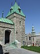
(National Historic Sites) -
[Site]: Henry-Stuart House
[Date(s)]: 1849 (completed)
[Designated]: 1999
[Location]: Quebec City46°48′8.99″N 71°13′26.09″W / 46.8024972°N 71.2239139°W / 46.8024972; -71.2239139 (Henry-Stuart House)
[Description]: A brick cottage set in a garden; a noted example of the "cottage orné" style in Quebec, evocative of the picturesque aesthetics favoured by British settlers
[Image]:
(National Historic Sites) -
[Site]: Holy Trinity Anglican Cathedral
[Date(s)]: 1804 (completed)
[Designated]: 1989
[Location]: Quebec City46°48′46.08″N 71°12′23.76″W / 46.8128000°N 71.2066000°W / 46.8128000; -71.2066000 (Holy Trinity Anglican Cathedral)
[Description]: A simple Palladian-style church, the construction of which introduced British classicism to Quebec City; the first purpose-built Anglican cathedral outside the British Isles
[Image]: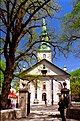
(National Historic Sites) -
[Site]: Hôpital-Général de Québec Cemetery
[Date(s)]: 1755 (established)
[Designated]: 1999
[Location]: Notre-Dame-des-Anges46°48′52.04″N 71°13′54.18″W / 46.8144556°N 71.2317167°W / 46.8144556; -71.2317167 (Hôpital-Général de Québec Cemetery)
[Description]: The small central part of the hospital cemetery, containing the graves of over 1000 French, British and aboriginal soldiers, many of whom died in the battles of the Plains of Abraham and Sainte-Foy, the two decisive battles between France and England for colonial supremacy of North America
[Image]:
(National Historic Sites) -
[Site]: Hôtel-Dieu de Québec
[Date(s)]: 1637 (established)
[Designated]: 1936
[Location]: Quebec City46°48′54.76″N 71°12′38.26″W / 46.8152111°N 71.2106278°W / 46.8152111; -71.2106278 (Hôtel-Dieu de Québec)
[Description]: The first permanent hospital established in North America north of Mexico
[Image]: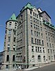
(National Historic Sites) -
[Site]: La Fabrique
[Date(s)]: 1871 (completed)
[Designated]: 2011
[Location]: Quebec City46°48′45″N 71°13′34″W / 46.81250°N 71.22611°W / 46.81250; -71.22611 (La Fabrique)
[Description]: The former Dominion Corset Manufacturing building; representative of female industrial workers in Canada's textile industries
[Image]:
(National Historic Sites) -
[Site]: Loyola House / National School Building
[Date(s)]: 1823 (completed)
[Designated]: 1989
[Location]: Quebec City46°48′44.97″N 71°12′44.61″W / 46.8124917°N 71.2123917°W / 46.8124917; -71.2123917 (Loyola House / National School Building)
[Description]: The oldest known Gothic Revival-style public building in Canada; erected in order to educate orphans, following the model of the National Society for Promoting Religious Education, the building housed a number of educational and charitable works; it was renamed Loyola House when it came to be owned by the Jesuits in 1904
[Image]:
(National Historic Sites) -
[Site]: Maillou House
[Date(s)]: 1737 (first storey completed), 1767 (second storey added)
[Designated]: 1958
[Location]: Quebec City46°48′42.62″N 71°12′23.18″W / 46.8118389°N 71.2064389°W / 46.8118389; -71.2064389 (Maillou House)
[Description]: A two-storey stone house that served as the residence of a number of notable figures of the French Regime and British colonial administration; served as the meeting place for the military council that governed Quebec from 1760 to 1764 and ultimately became the headquarters of the local militia
[Image]:
(National Historic Sites) -
[Site]: Manège militaire Voltigeurs de Québec
[Date(s)]: 1887 (completed)
[Designated]: 1986
[Location]: Quebec City46°48′22.68″N 71°12′50.4″W / 46.8063000°N 71.214000°W / 46.8063000; -71.214000 (Manège militaire Voltigeurs de Québec)
[Description]: Designed by Quebec architect Eugène-Étienne Taché, it was the precursor of the Chateau-style in Canadian architecture; unique among armouries in Canada due to its design, it was heavily damaged by fire in 2008
[Image]:
(National Historic Sites) -
[Site]: Montmorency Park
[Date(s)]: 1908 (park established)
[Designated]: 1966
[Location]: Quebec City46°48′49.05″N 71°12′14.64″W / 46.8136250°N 71.2040667°W / 46.8136250; -71.2040667 (Montmorency Park)
[Description]: An urban park that forms part of the Fortifications of Quebec NHS. A former building on the site housed the Parliament of the Province of Canada at various times between 1841 and 1866, hosted the Quebec Conference of 1864 that hammered out details of Confederation, and briefly accommodated the Legislative Assembly of Quebec
[Image]:
(National Historic Sites) -
[Site]: Morrin College / Former Quebec Prison
[Date(s)]: 1814 (completed)
[Designated]: 1981
[Location]: Quebec City46°48′45.74″N 71°12′37.77″W / 46.8127056°N 71.2104917°W / 46.8127056; -71.2104917 (Morrin College / Former Quebec Prison)
[Description]: A four-storey Palladian-style stone prison, converted to a college and home of the Literary and Historical Society of Quebec in the 19th century; the first prison in Canada to reflect the ideas of British reformer John Howard
[Image]:
(National Historic Sites) -
[Site]: Mount Hermon Cemetery
[Date(s)]: 1848 (established)
[Designated]: 2007
[Location]: Quebec City46°46′42.64″N 71°14′47.65″W / 46.7785111°N 71.2465694°W / 46.7785111; -71.2465694 (Mount Hermon Cemetery)
[Description]: The first rural cemetery in Canada, established in Sillery, near Quebec City, created due to overcrowding at the old Protestant burying ground in the city; the funerary monuments and significance of many of the persons buried in the cemetery commemorate many aspects of the history of Quebec City, Quebec and Canada
[Image]:
(National Historic Sites) -
[Site]: New Quebec Custom House
[Date(s)]: 1860 (completed)
[Designated]: 1972
[Location]: Quebec City46°49′2.43″N 71°12′4.5″W / 46.8173417°N 71.201250°W / 46.8173417; -71.201250 (New Quebec Custom House)
[Description]: A neoclassical, stone custom house with Italianate detailing; its construction reflected Quebec City's exceptional growth as a commercial and political centre in the mid 19th century
[Image]:
(National Historic Sites) -
[Site]: Notre-Dame-de-Lorette Church
[Date(s)]: 1722 (first church completed), 1865 (present church completed)
[Designated]: 1981
[Location]: Wendake46°51′22.32″N 71°21′16.92″W / 46.8562000°N 71.3547000°W / 46.8562000; -71.3547000 (Notre-Dame-de-Lorette Church)
[Description]: A church at the centre of Old Wendake Historic District; the establishment of this Jesuit mission was a significant step in the migration of the Huron-Wendat people
[Image]: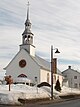
(National Historic Sites) -
[Site]: Notre-Dame Roman Catholic Cathedral
[Date(s)]: 1647 (first completed)
[Designated]: 1989
[Location]: Quebec City46°49′2.43″N 71°12′4.5″W / 46.8173417°N 71.201250°W / 46.8173417; -71.201250 (Notre-Dame Roman Catholic Cathedral)
[Description]: The first parish church of the colony of New France; first built in 1647, the present cathedral is the product of many reconstructions, and it has been a significant influence on ecclesiastical architecture in Quebec
[Image]:
(National Historic Sites) -
[Site]: Notre-Dame-des-Victoires Church
[Date(s)]: 1688 (completed)
[Designated]: 1988
[Location]: Quebec City46°48′46.08″N 71°12′9.72″W / 46.8128000°N 71.2027000°W / 46.8128000; -71.2027000 (Notre-Dame-des-Victoires Church)
[Description]: Built on the site of Samuel de Champlain’s 1608 Habitation, the first permanent French establishment in North America; a symbol of the French presence in North America
[Image]:
(National Historic Sites) -
[Site]: Old Quebec Custom House
[Date(s)]: 1832 (completed)
[Designated]: 1990
[Location]: Quebec City46°48′36.95″N 71°12′10.91″W / 46.8102639°N 71.2030306°W / 46.8102639; -71.2030306 (Old Quebec Custom House)
[Description]: An excellent and rare surviving example of a neoclassical-style government building from the 1830s
[Image]:
(National Historic Sites) -
[Site]: Old Wendake Historic District
[Date(s)]: 1697 (established)
[Designated]: 2000
[Location]: Wendake46°51′41.3″N 71°21′25.6″W / 46.861472°N 71.357111°W / 46.861472; -71.357111 (Old Wendake Historic District)
[Description]: A Huron-Wendat community established by those who survived the 17th-century dispersal of the inhabitants of Huronia
[Image]:
(National Historic Sites) -
[Site]: Quebec Bridge
[Date(s)]: 1917 (completed)
[Designated]: 1995
[Location]: Quebec City46°44′43.72″N 71°17′16.06″W / 46.7454778°N 71.2877944°W / 46.7454778; -71.2877944 (Quebec Bridge)
[Description]: The world's longest clear-span cantilever bridge; the first major bridge to use the K truss, and the first bridge in North America to be constructed with nickel steel
[Image]:
(National Historic Sites) -
[Site]: Quebec Citadel
[Date(s)]: 1720 (established); 1832 (completed)
[Designated]: 1946
[Location]: Quebec City46°48′28.45″N 71°12′30.55″W / 46.8079028°N 71.2084861°W / 46.8079028; -71.2084861 (Quebec Citadel)
[Description]: A fortress located on Cap Diamant which also forms part of the Fortifications of Quebec NHS; the secondary residence of the Governor General and the ceremonial home of the Royal 22e Régiment, the most famous francophone organization of the Canadian Forces
[Image]:
(National Historic Sites) -
[Site]: Quebec City Hall
[Date(s)]: 1896 (completed)
[Designated]: 1984
[Location]: Quebec City46°48′50.08″N 71°12′28.63″W / 46.8139111°N 71.2079528°W / 46.8139111; -71.2079528 (Quebec City Hall)
[Description]: A town hall of the late-Victorian period, whose opulently eclectic exterior and richly decorated interiors make it one of the most stately municipal buildings in Canada
[Image]:
(National Historic Sites) -
[Site]: Quebec Court House
[Date(s)]: 1887 (completed)
[Designated]: 1981
[Location]: Quebec City46°48′43.86″N 71°12′23.14″W / 46.8121833°N 71.2064278°W / 46.8121833; -71.2064278 (Quebec Court House)
[Description]: A Second Empire-style courthouse designed by Eugène-Étienne Taché; served as a courthouse for almost a century, and is a symbol of the judicial system in the province of Quebec
[Image]:
(National Historic Sites) -
[Site]: Quebec Garrison Club
[Date(s)]: 1816 (building completed), 1879 (club established)
[Designated]: 1999
[Location]: Quebec City46°48′34.32″N 71°12′38.99″W / 46.8095333°N 71.2108306°W / 46.8095333; -71.2108306 (Quebec Garrison Club)
[Description]: First constructed as an administrative headquarters by the Royal Engineers, the building also forms part of the Fortifications of Quebec NHS; in 1879, officers of the Canadian Militia established the only military club in Canada that follows the British colonial tradition of social gatherings between military officers and influential civilians. Managing secretary during the 1960s was Hugh Hamilton Smith.
[Image]:
(National Historic Sites) -
[Site]: Quebec Martello Towers
[Date(s)]: 1812 (completed)
[Designated]: 1990
[Location]: Quebec City46°48′33.66″N 71°13′38.49″W / 46.8093500°N 71.2273583°W / 46.8093500; -71.2273583 (Quebec Martello Towers)
[Description]: Three Martello towers at some distance from one another, also forming part of the Fortifications of Quebec NHS; the towers symbolize the importance of Quebec City and its fortifications to the defence of British North America in the early 19th century
[Image]:
(National Historic Sites) -
[Site]: Quebec Seminary
[Date(s)]: 1663 (established)
[Designated]: 1929
[Location]: Quebec City46°48′52.75″N 71°12′20.52″W / 46.8146528°N 71.2057000°W / 46.8146528; -71.2057000 (Quebec Seminary)
[Description]: One of the oldest educational institutions in Canada
[Image]:
(National Historic Sites) -
[Site]: Saint-Louis Forts and Châteaux
[Date(s)]: 1620 (first construction on site)
[Designated]: 2002
[Location]: Quebec City46°48′44.64″N 71°12′15.84″W / 46.8124000°N 71.2044000°W / 46.8124000; -71.2044000 (Saint-Louis Forts and Châteaux)
[Description]: Archaeological remains of 4 forts and 3 châteaux from both the French and British regimes; the seat of colonial executive authority for over 200 years, and the site of the official residences of 32 of the 40 Governors General from the colonial period
[Image]:
(National Historic Sites) -
[Site]: Sewell House
[Date(s)]: 1804 (completed)
[Designated]: 1969
[Location]: Quebec City46°48′35.1″N 71°12′36.76″W / 46.809750°N 71.2102111°W / 46.809750; -71.2102111 (Sewell House)
[Description]: The two-storey palladian residence of Chief Justice Jonathan Sewell; illustrative of the early 19th-century development of Quebec City's Upper Town
[Image]:
(National Historic Sites) -
[Site]: Têtu House
[Date(s)]: 1854 (completed)
[Designated]: 1973
[Location]: Quebec City46°48′36.21″N 71°12′23.81″W / 46.8100583°N 71.2066139°W / 46.8100583; -71.2066139 (Têtu House)
[Description]: A three-storey, stone townhouse designed in the Neoclassical style by Charles Baillairgé; excellent example of the urban townhouses built for wealthy Canadian merchants during the mid-19th century
[Image]:
(National Historic Sites) -
[Site]: Ursuline Monastery
[Date(s)]: 1639 (established)
[Designated]: 1972
[Location]: Quebec City46°48′43.54″N 71°12′29.26″W / 46.8120944°N 71.2081278°W / 46.8120944; -71.2081278 (Ursuline Monastery)
[Description]: A complex of 17th, 18th and 19th century stone buildings; the old monastery is the largest and most imposing vestige of 17th-century Canadian architecture and the chapel altar, made in 1730, is a masterpiece of French Canadian wood sculpture
[Image]:
(National Historic Sites)
New Random Display Display All Items(37)