


-
[Site]: Kingston Fortifications

[Date(s)]: 1840 (completed)
[Designated]: 1989
[Location]: Kingston44°13′20″N 76°29′25″W / 44.222275°N 76.490357°W / 44.222275; -76.490357 (Kingston Fortifications)
[Description]: A fortification system consisting of five installations (Fort Henry NHS, Fort Frederick, Murney Tower NHS, Shoal Tower NHS and Cathcart Tower), crucial to the 19th century defense of Kingston and the terminus of the Rideau Canal
[Image]:
(National Historic Sites) -
[Site]: Point Frederick Buildings
[Date(s)]:
[Designated]: 1973
[Location]: Kingston44°13′40.73″N 76°28′10.12″W / 44.2279806°N 76.4694778°W / 44.2279806; -76.4694778 (Point Frederick Buildings)
[Description]: A peninsula upon which a major British naval base was located during the War of 1812; an assemblage of architecturally significant structures used by the Royal Military College of Canada
[Image]:
(National Historic Sites) -
[Site]: Kingston City Hall and Market Square
[Date(s)]: 1844 (completed)
[Designated]: 1961
[Location]: Kingston44°13′47.68″N 76°28′50.1″W / 44.2299111°N 76.480583°W / 44.2299111; -76.480583 (Kingston City Hall)
[Description]: A prominent example of the Neoclassical style in Canada, with a landmark tholobate and dome; its scale and design are reflective of Kingtson's status at the time of construction as capital of the Province of Canada . The Kingston Public Market, founded in 1801, is behind city hall and part of the national historic site and is the oldest public market in Ontario.
[Image]: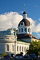
(National Historic Sites) -
[Site]: Fort Frontenac
[Date(s)]: 1673 (original fort completed)
[Designated]: 1923
[Location]: Kingston44°14′00″N 76°28′43″W / 44.23333°N 76.47861°W / 44.23333; -76.47861 (Fort Frontenac)
[Description]: Originally a French trading post that served as a gateway to the West, the base of Robert de LaSalle’s explorations and a French outpost against the Iroquois and English forces
[Image]:
(National Historic Sites) -
[Site]: Ann Baillie Building
[Date(s)]: 1904 (completed)
[Designated]: 1997
[Location]: Kingston 44°13′25.56″N 76°29′32.53″W / 44.2237667°N 76.4923694°W / 44.2237667; -76.4923694 (Ann Baillie Building)
[Description]: One of the first purpose-built nurses’ residences in Canada, the building represents the professionalization of nursing in Canada in the early 20th-century, and now serves as the Museum of Health Care
[Image]:
(National Historic Sites) -
[Site]: Murney Tower
[Date(s)]: 1846 (completed)
[Designated]: 1930
[Location]: Kingston44°13′20″N 76°29′26″W / 44.22228°N 76.490582°W / 44.22228; -76.490582 (Murney Tower)
[Description]: A martello tower located on Murray Point on the west shore of Kingston Harbour; also a component of the Kingston Fortifications National Historic Site of Canada
[Image]:
(National Historic Sites)
New Random Display Display All Items(22)