


-
[Site]: 1 Chipman Hill
[Date(s)]: 1854 (c.) (completed)
[Designated]: 1984
[Location]: Saint John45°16′26.66″N 66°3′47.43″W / 45.2740722°N 66.0631750°W / 45.2740722; -66.0631750 (1 Chipman Hill)
[Description]: Symbolic of upper-middle class urban housing in Saint John during the mid-19th century; features a variety of decorative trompe-l'œil wall and ceiling murals
[Image]: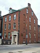
(National Historic Sites) -
[Site]: Arts Building
[Date(s)]: 1827 (completed)
[Designated]: 1951
[Location]: Fredericton45°56′53.93″N 66°38′28.65″W / 45.9483139°N 66.6412917°W / 45.9483139; -66.6412917 (Arts Building)
[Description]: A classically inspired masonry structure at the University of New Brunswick; the oldest university building in Canada still in continuous use
[Image]:
(National Historic Sites) -
[Site]: Augustine Mound
[Date(s)]: 500 (c.) BCE (established)
[Designated]: 1975
[Location]: Metepenagiag Mi'kmaq Nation46°55′48.37″N 65°49′20.06″W / 46.9301028°N 65.8222389°W / 46.9301028; -65.8222389 (Augustine Mound)
[Description]: A circular ritual site surrounding a burial mound; a sacred site representative of Mi'kmaq spirituality, exhibiting Adena burial rituals
[Image]:
(National Historic Sites) -
[Site]: Beaubears Island Shipbuilding

[Date(s)]: 1790 (established)
[Designated]: 2001
[Location]: Miramichi46°58′39″N 65°33′42″W / 46.977535°N 65.561670°W / 46.977535; -65.561670 (Beaubears Island Shipbuilding)
[Description]: A 24-hectare (59-acre) site featuring the remains of an early 19th-century shipyard
[Image]:
(National Historic Sites) -
[Site]: Belmont House / R. Wilmot Home
[Date(s)]: 1820 (completed)
[Designated]: 1975
[Location]: Lincoln45°54′49.39″N 66°35′14.05″W / 45.9137194°N 66.5872361°W / 45.9137194; -66.5872361 (Belmont House / R. Wilmot Home)
[Description]: A large neoclassical country house associated with Robert Duncan Wilmot, a Father of Confederation
[Image]:
(National Historic Sites) -
[Site]: Boishébert
[Date(s)]: 1756 (camp established)
[Designated]: 1930
[Location]: Miramichi46°58′11.17″N 65°34′42.99″W / 46.9697694°N 65.5786083°W / 46.9697694; -65.5786083 (Boishébert)
[Description]: The site of a camp at Wilson's Point and additionally comprising most of the adjacent Beaubears Island where Acadians, under the leadership of Charles Deschamps de Boishébert, sought refuge from 1756 to 1760 during the Expulsion of the Acadians
[Image]:
(National Historic Sites) -
[Site]: Carleton Martello Tower
[Date(s)]: 1815 (completed)
[Designated]: 1930
[Location]: Saint John45°15′7.53″N 66°4′33.54″W / 45.2520917°N 66.0759833°W / 45.2520917; -66.0759833 (Carleton Martello Tower)
[Description]: A martello tower located across the harbour from downtown Saint John, built to protect the city from an American land attack during the War of 1812; representative of the type of coastal defence used by the British during the Napoleonic era
[Image]:
(National Historic Sites) -
[Site]: Chandler House / Rocklyn
[Date(s)]: 1831 (completed)
[Designated]: 1971
[Location]: Dorchester45°53′54.78″N 64°30′54.56″W / 45.8985500°N 64.5151556°W / 45.8985500; -64.5151556 (Chandler House / Rocklyn)
[Description]: A Classical Revival-style house associated with Edward Barron Chandler, a Father of Confederation
[Image]:
(National Historic Sites) -
[Site]: Charlotte County Court House
[Date(s)]: 1840 (completed)
[Designated]: 1981
[Location]: St. Andrews45°4′32.47″N 67°2′57.26″W / 45.0756861°N 67.0492389°W / 45.0756861; -67.0492389 (Charlotte County Court House)
[Description]: A simple wood-frame courthouse with a pedimented portico; the best preserved example in New Brunswick of the typical mid-19th century Maritime courthouse
[Image]:
(National Historic Sites) -
[Site]: Christ Church Anglican
[Date(s)]: 1856 (completed)
[Designated]: 1990
[Location]: Maugerville45°52′17.08″N 66°26′46.72″W / 45.8714111°N 66.4463111°W / 45.8714111; -66.4463111 (Christ Church Anglican)
[Description]: A wooden church illustrative of the eccclesiological phase of Gothic Revival architecture in Canada
[Image]:
(National Historic Sites) -
[Site]: Christ Church Cathedral
[Date(s)]: 1853 (completed)
[Designated]: 1981
[Location]: Fredericton45°57′27″N 66°38′5.86″W / 45.95750°N 66.6349611°W / 45.95750; -66.6349611 (Christ Church Cathedral)
[Description]: A cathedral whose spire is a landmark in the historic centre of Fredericton; one of the best examples of ecclesiological Gothic Revival architecture in Canada, and one which established an architectural pattern followed in the design of many churches in 19th-century Canada
[Image]:
(National Historic Sites) -
[Site]: Connell House
[Date(s)]: 1840 (completed)
[Designated]: 1975
[Location]: Woodstock46°9′3.96″N 67°34′30.36″W / 46.1511000°N 67.5751000°W / 46.1511000; -67.5751000 (Connell House)
[Description]: A Greek Revival wooden mansion distinguished by a double-height columned verandah; in the early 19th century, large homes inspired by classical temples were common in the United States, but comparatively rare in Canada
[Image]:
(National Historic Sites) -
[Site]: Denys Fort / Habitation
[Date(s)]: 1600s (c.) (established)
[Designated]: 1952
[Location]: Shippagan47°52′52.75″N 64°35′22.02″W / 47.8813194°N 64.5894500°W / 47.8813194; -64.5894500 (Denys Fort / Habitation)
[Description]: Archaeological remains of a 17th-century French trading post
[Image]:
(National Historic Sites) -
[Site]: Fort Beauséjour – Fort Cumberland
[Date(s)]: 1751 (established)
[Designated]: 1920
[Location]: Aulac45°51′52.49″N 64°17′29.62″W / 45.8645806°N 64.2915611°W / 45.8645806; -64.2915611 (Fort Beauséjour – Fort Cumberland)
[Description]: A star-shaped fort that defended French interests in the Chignecto isthmus; after its capture by the British in 1755, the fort repulsed an attack by American revolutionary sympathizers in 1776, which contributed to keeping Nova Scotia in the British Empire
[Image]:
(National Historic Sites) -
[Site]: Fort Charnisay
[Date(s)]: 1645 (established)
[Designated]: 1923
[Location]: Saint John45°15′46.04″N 66°4′32.63″W / 45.2627889°N 66.0757306°W / 45.2627889; -66.0757306 (Fort Charnisay)
[Description]: The site of a succession of military forts between 1645 and 1775 due to its strategic position on the western edge of the city's harbour and overlooking the Saint John River; today the site is marked by a cairn and a boulder
[Image]:
(National Historic Sites) -
[Site]: Fort Gaspareaux
[Date(s)]: 1751 (established)
[Designated]: 1920
[Location]: Port Elgin46°2′34.4″N 64°4′14.7″W / 46.042889°N 64.070750°W / 46.042889; -64.070750 (Fort Gaspareaux)
[Description]: An archaeological site containing traces of a French fort; symbolic of the struggle between France and Britain for North America in the 1750s
[Image]:
(National Historic Sites) -
[Site]: Fort Howe
[Date(s)]: 1777 (established)
[Designated]: 1966
[Location]: Saint John45°16′36″N 66°04′23″W / 45.27667°N 66.07306°W / 45.27667; -66.07306 (Fort Howe)
[Description]: The partial reconstruction of a fort that guarded Saint John from the American Revolutionary War through to the War of 1812; the fort's designation as a National Historic Park in 1914 marked the beginning of Canada's emerging system of National Historic Sites
[Image]: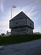
(National Historic Sites) -
[Site]: Fort Jemseg
[Date(s)]: 1659 (established)
[Designated]: 1927
[Location]: Jemseg45°46′6.72″N 66°7′56.01″W / 45.7685333°N 66.1322250°W / 45.7685333; -66.1322250 (Fort Jemseg)
[Description]: Site of an English trading post, captured by the Dutch in 1674
[Image]:
(National Historic Sites) -
[Site]: Fort La Tour
[Date(s)]: 1631 (established)
[Designated]: 1923
[Location]: Saint John45°16′21.76″N 66°4′20.18″W / 45.2727111°N 66.0722722°W / 45.2727111; -66.0722722 (Fort La Tour)
[Description]: An archaeological site containing the remains of a 17th-century fortified fur-trading post established by Charles de Saint-Étienne de la Tour; one of the earliest centres of the French fur trade with the Aboriginal peoples in the region
[Image]:
(National Historic Sites) -
[Site]: Fort Nashwaak (Naxoat)
[Date(s)]: 1691 (established)
[Designated]: 1924
[Location]: Fredericton45°57′40.87″N 66°37′36.07″W / 45.9613528°N 66.6266861°W / 45.9613528; -66.6266861 (Fort Nashwaak (Naxoat))
[Description]: The site of a French fort that had once sat at the mouth of the Nashwaak River where it meets the Saint John River; the base of many raids against New England, one of which resulted in the Siege of Pemaquid in 1696
[Image]:
(National Historic Sites) -
[Site]: Fort Nerepis
[Date(s)]: 1659 (fort established)
[Designated]: 1930
[Location]: Grand Bay–Westfield45°22′12″N 66°14′3.12″W / 45.37000°N 66.2342000°W / 45.37000; -66.2342000 (Fort Nerepis)
[Description]: A cairn marking the approximate site of a fortified Maliseet stronghold, and then a small French fort, at the confluence of the Nerepis River and Saint John River; the remains of the fortifications and their precise locations have never been found
[Image]:
(National Historic Sites) -
[Site]: Fredericton City Hall
[Date(s)]: 1876 (completed)
[Designated]: 1984
[Location]: Fredericton45°57′48.87″N 66°38′35.29″W / 45.9635750°N 66.6431361°W / 45.9635750; -66.6431361 (Fredericton City Hall)
[Description]: A three-storey, Second Empire style town hall; the oldest municipal hall in Atlantic Canada still used for civic administration
[Image]: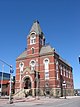
(National Historic Sites) -
[Site]: Fredericton Military Compound
[Date(s)]: 1784 (established)
[Designated]: 1960
[Location]: Fredericton45°57′45.58″N 66°38′26.64″W / 45.9626611°N 66.6407333°W / 45.9626611; -66.6407333 (Fredericton Military Compound)
[Description]: An important grouping of British colonial-era military buildings, which has served as premises for both military and government institutions for over 200 years
[Image]:
(National Historic Sites) -
[Site]: Free Meeting House
[Date(s)]: 1821 (completed)
[Designated]: 1990
[Location]: Moncton46°5′38.59″N 64°46′26.52″W / 46.0940528°N 64.7740333°W / 46.0940528; -64.7740333 (Free Meeting House)
[Description]: A simple wood-frame meeting house that, as the only local place of worship at the time, was used by all denominations; a symbol of religious tolerance in the Maritimes
[Image]:
(National Historic Sites) -
[Site]: Greenock Church
[Date(s)]: 1824 (completed)
[Designated]: 1994
[Location]: St. Andrews45°4′36.8″N 67°3′13.18″W / 45.076889°N 67.0536611°W / 45.076889; -67.0536611 (Greenock Church)
[Description]: A church noteworthy for its role in the development of Presbyterianism in New Brunswick; an excellent example of the Palladian style in Canadian church architecture
[Image]: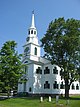
(National Historic Sites) -
[Site]: Gibson Family Plot
[Date(s)]: c. 1913 (begun)
[Designated]: 2010
[Location]: Fredericton45°59′12″N 66°35′39″W / 45.98667°N 66.59417°W / 45.98667; -66.59417 (Gibson Family Plot)
[Description]: Headstones of Alexander "Boss" Gibson, his wife and their family members, totaling 27 stones, arranged in a circle. The central stones are intricately carved from white granite.
[Image]:
(National Historic Sites) -
[Site]: Hammond House
[Date(s)]: 1889 (completed)
[Designated]: 1990
[Location]: Sackville45°53′58.65″N 64°22′37.16″W / 45.8996250°N 64.3769889°W / 45.8996250; -64.3769889 (Hammond House)
[Description]: A house built for artist John A. Hammond and now located on the campus of Mount Allison University; an excellent example of the Queen Anne Revival Style in Canadian domestic architecture
[Image]:
(National Historic Sites) -
[Site]: Hartland Covered Bridge
[Date(s)]: 1921 (completed)
[Designated]: 1980
[Location]: Hartland46°17′47.77″N 67°31′50.65″W / 46.2966028°N 67.5307361°W / 46.2966028; -67.5307361 (Hartland Covered Bridge)
[Description]: A wooden covered bridge crossing the Saint John River; the longest existing covered bridge in the world
[Image]:
(National Historic Sites) -
[Site]: Imperial / Bi-Capitol Theatre
[Date(s)]: 1913 (completed)
[Designated]: 1985
[Location]: Saint John45°16′21.82″N 66°3′27.82″W / 45.2727278°N 66.0577278°W / 45.2727278; -66.0577278 (Imperial / Bi-Capitol Theatre)
[Description]: An early 20th-century theatre facing onto King's Square; a nationally significant example of a theatre built specifically for live performances
[Image]:
(National Historic Sites) -
[Site]: La Coupe Dry Dock
[Date(s)]: 1700s (c.) (established)
[Designated]: 1933
[Location]: Aulac45°54′57″N 64°16′01″W / 45.915908°N 64.266962°W / 45.915908; -64.266962 (La Coupe Dry Dock)
[Description]: Site may represent 18th-century Acadian construction
[Image]:
(National Historic Sites) -
[Site]: Loyalist House
[Date(s)]: 1817 (completed)
[Designated]: 1958
[Location]: Saint John45°16′28.42″N 66°3′40.51″W / 45.2745611°N 66.0612528°W / 45.2745611; -66.0612528 (Loyalist House)
[Description]: An excellent example of New England-style Federal architecture, and representative of the houses built by prosperous United Empire Loyalists; one of the oldest residences in the city and a survivor of the Great Fire, the house was maintained by five generations of the same family until 1959
[Image]:
(National Historic Sites) -
[Site]: Marine Hospital
[Date(s)]: 1831 (completed)
[Designated]: 1989
[Location]: Miramichi47°1′20.07″N 65°30′37.22″W / 47.0222417°N 65.5103389°W / 47.0222417; -65.5103389 (Marine Hospital)
[Description]: A sandstone building with a domed cupola, overlooking the Miramichi River; the oldest surviving marine hospital in Canada
[Image]:
(National Historic Sites) -
[Site]: Marysville Cotton Mill
[Date(s)]: 1885 (completed)
[Designated]: 1986
[Location]: Fredericton45°58′41.65″N 66°35′19.69″W / 45.9782361°N 66.5888028°W / 45.9782361; -66.5888028 (Marysville Cotton Mill)
[Description]: A four-storey, red-brick cotton mill building with a central tower; representative of the brick pier mills that were common in the Canadian textile industry
[Image]:
(National Historic Sites) -
[Site]: Marysville Historic District
[Date(s)]: 1840 (c.) (established)
[Designated]: 1993
[Location]: Fredericton45°58′44.01″N 66°35′17.44″W / 45.9788917°N 66.5881778°W / 45.9788917; -66.5881778 (Marysville Historic District)
[Description]: A former industrial community on the banks of the Nashwaak River; a rare surviving example of a 19th-century, single-industry company town with both its plant and company housing intact
[Image]:
(National Historic Sites) -
[Site]: McAdam Railway Station (Canadian Pacific)
[Date(s)]: 1901 (completed)
[Designated]: 1976
[Location]: McAdam45°35′20.4″N 67°19′48″W / 45.589000°N 67.33000°W / 45.589000; -67.33000 (McAdam Railway Station (Canadian Pacific))
[Description]: A stone, Chateau-style railway station and hotel; associated with the period of the rapid growth of the Canadian Pacific Railway and a rare surviving example of a combined station and hotel
[Image]:
(National Historic Sites) -
[Site]: Meductic Indian Village / Fort Meductic
[Date(s)]: 1600s (c.)
[Designated]: 1924
[Location]: Meductic45°35′20.4″N 67°19′48″W / 45.589000°N 67.33000°W / 45.589000; -67.33000 (Meductic Indian Village / Fort Meductic)
[Description]: The principal settlement of the Maliseet in the 17th century, and an important fur trading centre; the construction of the Mactaquac Dam in 1968 flooded the site, and the cairn marking the site was moved to nearby Fort Meductic Road
[Image]:
(National Historic Sites) -
[Site]: Minister's Island
[Date(s)]: 1889 (estate established)
[Designated]: 1996
[Location]: St. Andrews45°35′20.4″N 67°19′48″W / 45.589000°N 67.33000°W / 45.589000; -67.33000 (Minister's Island)
[Description]: The picturesque summer estate and gentleman's farm of William Cornelius Van Horne on a 280-hectare (690-acre) island in Passamaquoddy Bay
[Image]:
(National Historic Sites) -
[Site]: Minister's Island Pre-contact Sites
[Date(s)]: 1000 (c.) BCE (established)
[Designated]: 1978
[Location]: St. Andrews45°35′20.4″N 67°19′48″W / 45.589000°N 67.33000°W / 45.589000; -67.33000 (Minister's Island Pre-contact Sites)
[Description]: Archaeological sites containing the remains of four houses and a shell midden originating from a coastal winter settlement
[Image]:
(National Historic Sites) -
[Site]: Miscou Island Lighthouse
[Date(s)]: 1856 (completed)
[Designated]: 1974
[Location]: Miscou Island48°0′32.4″N 64°29′27.6″W / 48.009000°N 64.491000°W / 48.009000; -64.491000 (Miscou Island Lighthouse)
[Description]: One of the few remaining wooden, octagonal, tapered lighthouses in Canada; among the oldest in the Gulf of Saint Lawrence region
[Image]:
(National Historic Sites) -
[Site]: Monument Lefebvre
[Date(s)]: 1856 (completed)
[Designated]: 1994
[Location]: Memramcook45°58′45.8″N 64°33′59.98″W / 45.979389°N 64.5666611°W / 45.979389; -64.5666611 (Monument Lefebvre)
[Description]: Built in memory of Camille Lefebvre, who founded the first French language institution to confer university degrees in Atlantic Canada; now serves as an Acadian cultural centre
[Image]:
(National Historic Sites) -
[Site]: Number 2 Mechanics' Volunteer Company Engine House
[Date(s)]: 1841 (completed)
[Designated]: 1995
[Location]: Saint John45°16′24.56″N 66°3′24.61″W / 45.2734889°N 66.0568361°W / 45.2734889; -66.0568361 (Number 2 Mechanics' Volunteer Company Engine House)
[Description]: The oldest remaining fire hall in Canada built to house hand-operated pumper fire engines; symbolic of the early phase in fire fighting in Canada when volunteer fire companies were the primary line of defence against fires in Victorian-era cities
[Image]: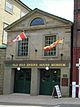
(National Historic Sites) -
[Site]: Old Government House
[Date(s)]: 1828 (completed)
[Designated]: 1958
[Location]: Fredericton45°57′56.52″N 66°39′21.36″W / 45.9657000°N 66.6559333°W / 45.9657000; -66.6559333 (Old Government House)
[Description]: The stone Palladian-style official residence of the Lieutenant Governor; the location of a historic 1866 meeting between Governor Arthur Gordon and Premier Albert James Smith which paved the way for the colony's entry into Confederation
[Image]:
(National Historic Sites) -
[Site]: Ordnance Building
[Date(s)]: 1842 (built)
[Designated]: 2015
[Location]: Saint John45°15′55″N 66°03′15″W / 45.265366°N 66.054256°W / 45.265366; -66.054256
[Description]: Rare colonial-era military ordnance building, it survived the Great Fire of 1877
[Image]:
(National Historic Sites) -
[Site]: Our Lady of the Assumption Cathedral
[Date(s)]: 1939-40 (built)
[Designated]: 2018
[Location]: Moncton46°05′27″N 64°46′54″W / 46.09083°N 64.78167°W / 46.09083; -64.78167
[Description]:
[Image]:
(National Historic Sites) -
[Site]: Oxbow
[Date(s)]: 1000 BCE (c.) (community established)
[Designated]: 1982
[Location]: Metepenagiag Mi'kmaq Nation46°56′19.6″N 65°48′40.18″W / 46.938778°N 65.8111611°W / 46.938778; -65.8111611 (Oxbow)
[Description]: A site where stratified archaeological resources are buried in the silts and gravels of the Little Southwest Miramichi River bank; a unique cultural record of a 3000-year Mi’kmaq community
[Image]:
(National Historic Sites) -
[Site]: Partridge Island Quarantine Station
[Date(s)]: 1830 (established)
[Designated]: 1974
[Location]: Saint John45°14′21.2″N 66°3′11.8″W / 45.239222°N 66.053278°W / 45.239222; -66.053278 (Partridge Island Quarantine Station)
[Description]: One of two major quarantine stations in Canada in the 19th century, established to protect the citizenry from contagious diseases carried by passengers and crews of in-coming ships
[Image]:
(National Historic Sites) -
[Site]: Prince William Streetscape
[Date(s)]: 1877 (construction after Great Fire)
[Designated]: 1981
[Location]: Saint John45°16′16.95″N 66°3′42.59″W / 45.2713750°N 66.0618306°W / 45.2713750; -66.0618306 (Prince William Streetscape)
[Description]: A concentration of architecturally notable late 19th-century public and commercial buildings within a two-block area
[Image]:
(National Historic Sites) -
[Site]: Rothesay Railway Station (European and North American)
[Date(s)]: 1860 (completed)
[Designated]: 1976
[Location]: Rothesay45°23′21.8″N 65°59′57.07″W / 45.389389°N 65.9991861°W / 45.389389; -65.9991861 (Rothesay Railway Station (European and North American))
[Description]: A railway station with stationmaster's quarters on the second storey; commemorates the development of railways in the Maritimes and is a good surviving example of a number two standard station designed by the European and North American Railway
[Image]:
(National Historic Sites) -
[Site]: Saint John City Market
[Date(s)]: 1876 (completed)
[Designated]: 1986
[Location]: Saint John45°16′26.11″N 66°3′35.69″W / 45.2739194°N 66.0599139°W / 45.2739194; -66.0599139 (Saint John City Market)
[Description]: A rare and notable surviving example of a 19th-century market building
[Image]:
(National Historic Sites) -
[Site]: Saint John County Court House
[Date(s)]: 1829 (completed)
[Designated]: 1974
[Location]: Saint John45°16′25.35″N 66°3′24.65″W / 45.2737083°N 66.0568472°W / 45.2737083; -66.0568472 (Saint John County Court House)
[Description]: A neoclassical court house typical of early-19th-century, British public buildings in Canada; representative of the judicial system in the province
[Image]:
(National Historic Sites) -
[Site]: Seal Cove Smoked Herring Stands
[Date(s)]: 1870 (established)
[Designated]: 1995
[Location]: Grand Manan Island44°39′6.76″N 66°50′20.66″W / 44.6518778°N 66.8390722°W / 44.6518778; -66.8390722 (Seal Cove Smoked Herring Stands)
[Description]: 54 wooden buildings surrounding a cove bounded by breakwaters; a cultural landscape once typical of the Maritimes, but increasingly rare today, and evocative of the Atlantic herring fishery
[Image]:
(National Historic Sites) -
[Site]: St. Andrews Blockhouse
[Date(s)]: 1813 (completed)
[Designated]: 1962
[Location]: St Andrews45°4′37.51″N 67°3′42.81″W / 45.0770861°N 67.0618917°W / 45.0770861; -67.0618917 (St. Andrews Blockhouse)
[Description]: One of the few surviving Canadian examples of a War of 1812 blockhouse; built by the citizens of St. Andrews to protect the town from American raiders
[Image]:
(National Historic Sites) -
[Site]: St. Andrews Historic District
[Date(s)]: 1783 (town founded)
[Designated]: 1962
[Location]: St Andrews45°4′23.37″N 67°2′50.56″W / 45.0731583°N 67.0473778°W / 45.0731583; -67.0473778 (St. Andrews Historic District)
[Description]: A grid of sixty blocks comprising the original part of the present town; a fine example of a town in Canada that still reflects an 18th-century British colonial town plan
[Image]:
(National Historic Sites) -
[Site]: St. Anne's Chapel of Ease
[Date(s)]: 1847 (completed)
[Designated]: 1989
[Location]: Fredericton45°57′40.01″N 66°38′54.36″W / 45.9611139°N 66.6484333°W / 45.9611139; -66.6484333 (St. Anne's Chapel of Ease)
[Description]: A small Gothic Revival stone church reflective of the influence of the principles of the Cambridge Camden Society in Canada
[Image]:
(National Historic Sites) -
[Site]: St. John's Anglican Church / Stone Church
[Date(s)]: 1826 (completed)
[Designated]: 1989
[Location]: Saint John45°16′34.1″N 66°3′41.67″W / 45.276139°N 66.0615750°W / 45.276139; -66.0615750 (St. John's Anglican Church / Stone Church)
[Description]: An early Anglican church; one of the earliest examples of this first phase of the Gothic Revival style in Canada, known as Romantic Gothic Revival
[Image]:
(National Historic Sites) -
[Site]: St. Luke's Anglican Church
[Date(s)]: 1833 (completed)
[Designated]: 1994
[Location]: Quispamsis45°26′38.19″N 65°59′17.33″W / 45.4439417°N 65.9881472°W / 45.4439417; -65.9881472 (St. Luke's Anglican Church)
[Description]: A wooden church that represents one of the best examples of an Anglican church in Canada that reflects the architectural traditions of James Gibbs and Christopher Wren
[Image]:
(National Historic Sites) -
[Site]: St. Paul's United Church
[Date(s)]: 1886 (completed)
[Designated]: 1990
[Location]: Fredericton45°57′35.5″N 66°38′43.38″W / 45.959861°N 66.6453833°W / 45.959861; -66.6453833 (St. Paul's United Church)
[Description]: A former Presbyterian, now United, church; it is an excellent example of the High Victorian Gothic Revival style in Canada
[Image]:
(National Historic Sites) -
[Site]: St. Stephen Post Office
[Date(s)]: 1887 (completed)
[Designated]: 1983
[Location]: St. Stephen45°11′33.05″N 67°16′37.67″W / 45.1925139°N 67.2771306°W / 45.1925139; -67.2771306 (St. Stephen Post Office)
[Description]: A Romanesque Revival building constructed for the local post office, customs offices and internal revenue offices, and having served as the town hall since 1965, it is a fine example of the small urban post offices designed by Thomas Fuller
[Image]:
(National Historic Sites) -
[Site]: Tilley House
[Date(s)]: 1810 (completed)
[Designated]: 1965
[Location]: Gagetown45°46′57.77″N 66°8′36.03″W / 45.7827139°N 66.1433417°W / 45.7827139; -66.1433417 (Tilley House)
[Description]: A clapboard house that was the birthplace and boyhood home of Sir Samuel Leonard Tilley, a Father of Confederation
[Image]:
(National Historic Sites) -
[Site]: Tonge's Island
[Date(s)]: 1678 (established as capital)
[Designated]: 1925
[Location]: Sackville45°51′11.18″N 64°16′39.97″W / 45.8531056°N 64.2777694°W / 45.8531056; -64.2777694 (Tonge's Island)
[Description]: A settlement established in 1676 by Michel Leneuf de la Vallière, which served as the capital of Acadia from 1678 to 1684
[Image]:
(National Historic Sites) -
[Site]: Trinity Church and Rectory
[Date(s)]: 1789 (completed)
[Designated]: 1977
[Location]: Kingston45°30′9.45″N 65°58′32.8″W / 45.5026250°N 65.975778°W / 45.5026250; -65.975778 (Trinity Church and Rectory)
[Description]: The oldest surviving Anglican church in New Brunswick and a rare Maritimes example of a church and rectory surviving as a unit
[Image]:
(National Historic Sites) -
[Site]: William Brydone Jack Observatory
[Date(s)]: 1851 (completed)
[Designated]: 1954
[Location]: Fredericton45°56′53.03″N 66°38′26.53″W / 45.9480639°N 66.6407028°W / 45.9480639; -66.6407028 (William Brydone Jack Observatory)
[Description]: A wooden, octagonal tower that was the first astronomical observatory in Canada
[Image]:
(National Historic Sites) -
[Site]: Wolastoq (Saint John River)
[Date(s)]:
[Designated]: 2011
[Location]: Section of the Saint John River between Edmundston and the Bay of Fundy45°16′0″N 66°4′0″W / 45.26667°N 66.06667°W / 45.26667; -66.06667 (Wolastoq)
[Description]: A river that played an important role in 10,000 years of Maliseet history and 400 years of European settlement
[Image]:
(National Historic Sites) -
[Site]: York County Court House
[Date(s)]: 1858 (completed)
[Designated]: 1980
[Location]: Fredericton45°57′39.58″N 66°38′14.82″W / 45.9609944°N 66.6374500°W / 45.9609944; -66.6374500 (York County Court House)
[Description]: The earliest surviving New Brunswick court house constructed of brick
[Image]:
(National Historic Sites)
New Random Display Display All Items(64)