


-
[Site]: Atwater Library of the Mechanics' Institute of Montreal
[Date(s)]: 1920 (completed)
[Designated]: 2005
[Location]: Montreal45°29′19.17″N 73°35′3.41″W / 45.4886583°N 73.5842806°W / 45.4886583; -73.5842806 (Atwater Library of the Mechanics' Institute of Montreal)
[Description]: The home of the first Mechanics' Institute in Canada (established 1828), and the oldest subscription library in Canada; the last Mechanics' Institute building in Canada serving its original purposes
[Image]:
(National Historic Sites) -
[Site]: Bank of Montreal
[Date(s)]: 1894 (completed)
[Designated]: 1990
[Location]: Montreal45°29′15.81″N 73°34′7.45″W / 45.4877250°N 73.5687361°W / 45.4877250; -73.5687361 (Bank of Montreal National Historic Site)
[Description]: A 31⁄2-storey sandstone former bank branch; the building is a rare surviving example of a commercial building in Canada in the Queen Anne Revival style
[Image]:
(National Historic Sites) -
[Site]: Battle of Rivière des Prairies / Battle of Coulée Grou
[Date(s)]: 1690 (battle)
[Designated]: 1924
[Location]: Montreal45°41′56.07″N 73°30′13.68″W / 45.6989083°N 73.5038000°W / 45.6989083; -73.5038000 (Battle of Rivière des Prairies / Battle of Coulée Grou)
[Description]: The site of a battle between a group of Iroquois and a group of French settlers in 1690
[Image]:
(National Historic Sites) -
[Site]: Battle of the Lake of Two Mountains
[Date(s)]: 1689 (battle)
[Designated]: 1925
[Location]: Senneville45°26′52.69″N 73°56′25.41″W / 45.4479694°N 73.9403917°W / 45.4479694; -73.9403917 (Battle of the Lake of Two Mountains)
[Description]: A skirmish at Lake of Two Mountains between 28 coureurs de bois and a group of 22 Iroquois; the Iroquois defeat restored confidence among the French settlers in the area that had been shaken by the Lachine massacre
[Image]:
(National Historic Sites) -
[Site]: Black Watch (Royal Highland Regiment) of Canada Armoury
[Date(s)]: 1906 (completed)
[Designated]: 2008
[Location]: Montreal45°30′28.37″N 73°34′11.38″W / 45.5078806°N 73.5698278°W / 45.5078806; -73.5698278 (Black Watch (Royal Highland Regiment) of Canada Armoury)
[Description]: Home to The Black Watch (Royal Highland Regiment) of Canada, one of Canada's oldest regiments and its oldest surviving Highland Regiment; a testament to the important roles played by armouries in Canada's military history
[Image]:
(National Historic Sites) -
[Site]: Bonsecours Market
[Date(s)]: 1847 (completed)
[Designated]: 1984
[Location]: Montreal45°30′32.21″N 73°33′5.18″W / 45.5089472°N 73.5514389°W / 45.5089472; -73.5514389 (Bonsecours Market)
[Description]: A monumental, domed masonry civic building that occupies a full city block, originally built to house the city's first city hall, a public market, exhibition rooms and a concert hall; it was the largest town hall built in Canada during the mid-19th-century and reflected Montreal's rise as a metropolis
[Image]:
(National Historic Sites) -
[Site]: Château De Ramezay / India House
[Date(s)]: 1705 (completed), 1756 (rebuilt after fire)
[Designated]: 1949
[Location]: Montreal45°30′31.54″N 73°33′11.28″W / 45.5087611°N 73.5531333°W / 45.5087611; -73.5531333 (Château De Ramezay / India House)
[Description]: A stone mansion built for Claude de Ramezay, Governor of Montreal; it played an important role in the political and commercial life of New France and of Lower Canada for two centuries, housing the Compagnie des Indes occidentales starting in the 1740s and serving as official residence of the Governors-in-Chief of British North America commencing in the 1770s
[Image]:
(National Historic Sites) -
[Site]: Christ Church Cathedral
[Date(s)]: 1860 (completed)
[Designated]: 1999
[Location]: Montreal45°30′13.21″N 73°34′12.04″W / 45.5036694°N 73.5700111°W / 45.5036694; -73.5700111 (Christ Church Cathedral)
[Description]: An excellent example of a Gothic Revival-style cathedral; associated with the historic growth and development of Montreal through its congregation, whose members included many of the city's leading industrialists and businessmen
[Image]:
(National Historic Sites) -
[Site]: Church of Notre-Dame-de-la-Défense
[Date(s)]: 1919 (completed)
[Designated]: 2002
[Location]: Montreal45°32′5.82″N 73°36′41.28″W / 45.5349500°N 73.6114667°W / 45.5349500; -73.6114667 (Church of Notre-Dame-de-la-Défense)
[Description]: A Romanesque Revival style church in Montreal's Little Italy, specifically designed for an Italian Canadian parish; closely associated with Canada's oldest Italian community, established in Montreal in the 1860s
[Image]:
(National Historic Sites) -
[Site]: Church of Saint-Léon-de-Westmount
[Date(s)]: 1903 (completed)
[Designated]: 1997
[Location]: Westmount<be>45°29′7.58″N 73°35′30.75″W / 45.4854389°N 73.5918750°W / 45.4854389; -73.5918750 (Church of Saint-Léon-de-Westmount)
[Description]: One of the best examples of mural decoration dating from a period when the use of murals was prevalent in Canada; one of the few known examples in the country of a work executed in the buon fresco technique, and the best example of a comprehensive interior decor done by Guido Nincheri
[Image]:
(National Historic Sites) -
[Site]: Ernest Cormier House
[Date(s)]: 1930-31 (built)
[Designated]: 2018
[Location]: Montreal45°30′01″N 73°35′07″W / 45.50028°N 73.58528°W / 45.50028; -73.58528 (Cormier House National Historic Site)
[Description]: Eclectic house designed by Ernest Cormier for himself; later the residence of retired Prime Minister Pierre Trudeau
[Image]:
(National Historic Sites) -
[Site]: Erskine and American United Church
[Date(s)]: 1894 (completed)
[Designated]: 1998
[Location]: Montreal45°29′56.98″N 73°34′47.4″W / 45.4991611°N 73.579833°W / 45.4991611; -73.579833 (Erskine and American United Church)
[Description]: An excellent example of a large Romanesque Revival church known for its unusual fenestration patterns and attractive stonework; the windows by Louis Comfort Tiffany represent the most extensive collection of Tiffany's religious stained glass windows in Canada
[Image]:
(National Historic Sites) -
[Site]: Former Montreal Custom House
[Date(s)]: 1838 (completed)
[Designated]: 1997
[Location]: Montreal45°30′11.98″N 73°33′16.5″W / 45.5033278°N 73.554583°W / 45.5033278; -73.554583 (Former Montreal Custom House)
[Description]: An excellent example of Palladian architecture in Canada, designed by John Ostell, and one of the last Canadian public buildings to use the Palladian style; its construction marked the end of Montreal's lesser importance in comparison with Quebec City
[Image]:
(National Historic Sites) -
[Site]: George Stephen House / Mount Stephen Club
[Date(s)]: 1881 (completed)
[Designated]: 1971
[Location]: Montreal45°29′56.73″N 73°34′32.93″W / 45.4990917°N 73.5758139°W / 45.4990917; -73.5758139 (George Stephen House / Mount Stephen Club)
[Description]: A large, stone Victorian mansion that is the best example of a Renaissance Revival house in Canada; the home of George Stephen, 1st Baron Mount Stephen, president of the Bank of Montreal and of the Canadian Pacific Railway in the late 19th century
[Image]:
(National Historic Sites) -
[Site]: Grey Nuns' Hospital
[Date(s)]: 1765 (completed)
[Designated]: 1973
[Location]: Montreal45°30′1.31″N 73°33′17.2″W / 45.5003639°N 73.554778°W / 45.5003639; -73.554778 (Grey Nuns' Hospital)
[Description]: A three-and-a-half building that is an example of early French Canadian architecture and is the one surviving building of the Grey Nuns' Hospital complex; the Sisters of Charity, founded by Marie-Marguerite d'Youville, tended the sick and dispossessed here until 1871, and it is from this building that they extended their ministry across Canada
[Image]:
(National Historic Sites) -
[Site]: H. Vincent Meredith Residence
[Date(s)]: 1897 (completed)
[Designated]: 1990
[Location]: Montreal45°30′15.11″N 73°34′54.7″W / 45.5041972°N 73.581861°W / 45.5041972; -73.581861 (H. Vincent Meredith Residence)
[Description]: Representative of the mansions built by Montreal's elite in the late 19th century in the Golden Square Mile and a noted example of a house in the Queen Anne Revival-style; built for businessman and philanthropist Vincent Meredith and his wife, Lady Meredith, now serving as the McGill Centre for Medicine, Ethics and Law.
[Image]:
(National Historic Sites) -
[Site]: Hersey Pavilion
[Date(s)]: 1905 (completed)
[Designated]: 1997
[Location]: Montreal45°30′30.94″N 73°34′50.01″W / 45.5085944°N 73.5805583°W / 45.5085944; -73.5805583 (Hersey Pavilion)
[Description]: One of the first purpose-built nurses' residences in Canada, located on the Royal Victoria Hospital campus; symbolic of the history of training and the professionalism of nurses in Canada
[Image]:
(National Historic Sites) -
[Site]: Hochelaga
[Date(s)]: 1300s (ca.) (first construction of fortified villages in area, as later witnessed by Cartier), 1535 (arrival of Cartier)
[Designated]: 1920
[Location]: Montreal45°30′12.83″N 73°34′30.58″W / 45.5035639°N 73.5751611°W / 45.5035639; -73.5751611 (Hochelaga)
[Description]: A grass-covered area about 79 square metres (850 sq ft) in area with a stone marker, located to the left of the main entrance of McGill University; representative of the Iroquois village of Hochelaga that was visited by Jacques Cartier, the first European to reach the future site of Montreal, in 1535
[Image]:
(National Historic Sites) -
[Site]: Lachine Canal

[Date(s)]: 1825 (completed)
[Designated]: 1929
[Location]: Montreal45°27′30″N 73°36′42″W / 45.45833°N 73.61167°W / 45.45833; -73.61167 (Lachine Canal)
[Description]: An early 19th-century canal, 14 kilometres (8.7 mi) in length, built to circumvent white water on the St. Lawrence River; the head of a canal network linking the Great Lakes and the interior of the continent to the Atlantic Ocean
[Image]:
(National Historic Sites) -
[Site]: Lachine Canal Manufacturing Complex
[Date(s)]: 1825 (completed)
[Designated]: 1996
[Location]: Montreal45°27′30″N 73°36′42″W / 45.45833°N 73.61167°W / 45.45833; -73.61167 (Lachine Canal Manufacturing Complex)
[Description]: An important manufacturing and industrial complex, with the number of firms and diversity of its output at its zenith (1880 to 1940) unparalleled elsewhere in Canada; at one time, over 20% of the workforce of the Island of Montreal was employed in the area
[Image]:
(National Historic Sites) -
[Site]: Last Post Fund National Field of Honour
[Date(s)]: 1930 (established)
[Designated]: 2007
[Location]: Pointe-Claire45°26′38.80″N 73°50′15.58″W / 45.4441111°N 73.8376611°W / 45.4441111; -73.8376611 (Last Post Fund National Field of Honour)
[Description]: A military cemetery for veterans who died in a hospital or a public establishment after their military service; symbolic of principles such as the equality of soldiers in death and perpetual remembrance
[Image]:
(National Historic Sites) -
[Site]: LeBer-LeMoyne House
[Date(s)]: 1671 (completed)
[Designated]: 2002
[Location]: Montreal45°25′48″N 73°39′59″W / 45.43000°N 73.66639°W / 45.43000; -73.66639 (LeBer-LeMoyne House)
[Description]: A 17th-century fieldstone former fur trading post; the oldest known extant buildings associated with Charles LeMoyne and the fur trade during the French Regime
[Image]:
(National Historic Sites) -
[Site]: Louis-Joseph Papineau
[Date(s)]: 1785 (completed)
[Designated]: 1968
[Location]: Montreal45°30′35.77″N 73°33′7.88″W / 45.5099361°N 73.5521889°W / 45.5099361; -73.5521889 (Louis-Joseph Papineau)
[Description]: A 21⁄2-storey stone house that was the Papineau family home in Montreal; associated with the most important period in Papineau's life when he was the leader of the Parti canadien and one of the leading figures in the Lower Canada Rebellion
[Image]:
(National Historic Sites) -
[Site]: Maison Cartier
[Date(s)]: 1813 (completed)
[Designated]: 1982
[Location]: Montreal45°30′28.56″N 73°33′9.18″W / 45.5079333°N 73.5525500°W / 45.5079333; -73.5525500 (Maison Cartier)
[Description]: Two 21⁄2-storey stone attached houses that are typical of pre-industrial construction in Canada; originally constructed for Louis Parthenais and Augustin Perrault
[Image]:
(National Historic Sites) -
[Site]: Maison Saint-Gabriel
[Date(s)]: 1668 (completed)
[Designated]: 2007
[Location]: Montreal45°28′33.37″N 73°33′21.58″W / 45.4759361°N 73.5559944°W / 45.4759361; -73.5559944 (Maison Saint-Gabriel)
[Description]: A fieldstone house that was home to the sisters of the Congregation of Notre Dame, who operated a farm for more than 300 years, making it one of the oldest surviving farm properties in Canada; an exceptional example of rural architecture of the French Regime
[Image]:
(National Historic Sites) -
[Site]: Marie-Reine-du-Monde Cathedral
[Date(s)]: 1894 (consecrated)
[Designated]: 1999
[Location]: Montreal45°29′57.86″N 73°34′7.36″W / 45.4994056°N 73.5687111°W / 45.4994056; -73.5687111 (Marie-Reine-du-Monde Cathedral)
[Description]: A Baroque Revival cathedral that, when built, represented a break from the dominance of the Gothic Revival style in church architecture in Montreal; inspired by St. Peter's Basilica in Rome, it is the most significant symbol of ultramontanism in Canada
[Image]:
(National Historic Sites) -
[Site]: Marlborough Apartments
[Date(s)]: 1900 (completed)
[Designated]: 1990
[Location]: Montreal45°30′25.07″N 73°34′32.6″W / 45.5069639°N 73.575722°W / 45.5069639; -73.575722 (Marlborough Apartments)
[Description]: A four-storey, red brick apartment building that is an excellent example of the start of the 20th century apartment design in Canada; Queen Anne design was a popular style for luxury domestic architecture across Canada in this period, and this is one of the few Queen Anne apartment buildings that has survived in the country
[Image]: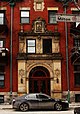
(National Historic Sites) -
[Site]: Masonic Memorial Temple
[Date(s)]: 1930 (completed)
[Designated]: 2001
[Location]: Montreal45°29′40.92″N 73°34′58.85″W / 45.4947000°N 73.5830139°W / 45.4947000; -73.5830139 (Masonic Memorial Temple)
[Description]: A monumental masonic temple resembling a Greek temple, built to honour the Freemasons who served in the First World War; an exceptional example of late Beaux-Arts architecture in Canada
[Image]:
(National Historic Sites) -
[Site]: Merchants Textile Mill
[Date(s)]: 1882 (established)
[Designated]: 1989
[Location]: Montreal45°28′32″N 73°34′48″W / 45.47556°N 73.58000°W / 45.47556; -73.58000 (Merchants Textile Mill)
[Description]: The second largest textile mill in Canada for the first four decades of the 20th century
[Image]:
(National Historic Sites) -
[Site]: Model City of Mount Royal
[Date(s)]: 1914 (district plan)
[Designated]: 2008
[Location]: Mount Royal45°30′58″N 73°38′35″W / 45.51611°N 73.64306°W / 45.51611; -73.64306
[Description]: A historic residential suburb developed in accordance with a 1914 district plan by Frederick Todd; a noted synthesis of the City Beautiful, Garden City and Garden Suburb movements, and remarkably homogeneous despite being constructed over the course of six decades
[Image]:
(National Historic Sites) -
[Site]: Monklands / Villa Maria Convent
[Date(s)]: 1804 (completed)
[Designated]: 1951
[Location]: Montreal45°28′54.53″N 73°37′1.6″W / 45.4818139°N 73.617111°W / 45.4818139; -73.617111 (Monklands / Villa Maria Convent)
[Description]: A two-storey stone Neo-Palladian mansion that served as the official residence of Governors General of Canada from 1844 to 1849
[Image]:
(National Historic Sites) -
[Site]: Montreal Botanical Garden
[Date(s)]: 1931 (established)
[Designated]: 2008
[Location]: Montreal45°33′26.00″N 73°33′24.50″W / 45.5572222°N 73.5568056°W / 45.5572222; -73.5568056 (Montreal Botanical Garden)
[Description]: A 75-hectare (190-acre) botanical garden; its collections and facilities rank it as one of the most important botanical gardens in the world
[Image]:
(National Historic Sites) -
[Site]: Montreal City Hall
[Date(s)]: 1878 (completed), 1922 (rebuilt)
[Designated]: 1984
[Location]: Montreal45°30′31.84″N 73°33′14.45″W / 45.5088444°N 73.5540139°W / 45.5088444; -73.5540139 (Montreal City Hall)
[Description]: A five-storey stone building and one of the best examples of the Second Empire style in the country; the first city hall to have been constructed in Canada solely for municipal administration, representing the growing importance of urban areas and municipal services in the late 19th century
[Image]: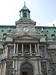
(National Historic Sites) -
[Site]: Montreal Forum
[Date(s)]: 1924 (completed)
[Designated]: 1997
[Location]: Montreal45°29′25″N 73°35′5″W / 45.49028°N 73.58472°W / 45.49028; -73.58472 (Montreal Forum)
[Description]: One of Canada's most famous sporting venues; an icon of Canadian culture due to its association with one of the most successful sporting franchises in North America, the Montreal Canadiens
[Image]:
(National Historic Sites) -
[Site]: Montreal's Birthplace
[Date(s)]: 1642 (event)
[Designated]: 1924
[Location]: Montreal45°30′12.27″N 73°33′14.31″W / 45.5034083°N 73.5539750°W / 45.5034083; -73.5539750 (Montreal's Birthplace)
[Description]: The location where Paul Chomedey de Maisonneuve laid the foundation of Montreal, as Fort Ville-Marie, on May 18, 1642
[Image]:
(National Historic Sites) -
[Site]: Monument National
[Date(s)]: 1893 (completed)
[Designated]: 1985
[Location]: Montreal45°30′32.76″N 73°33′45″W / 45.5091000°N 73.56250°W / 45.5091000; -73.56250 (Monument National)
[Description]: A four-storey theatre and cultural centre constructed by the Saint-Jean-Baptiste Society and then known as the "Heart of French America"; now occupied by the National Theatre School of Canada
[Image]: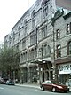
(National Historic Sites) -
[Site]: Mother House of the Grey Nuns of Montreal
[Date(s)]: 1871 (completed)
[Designated]: 2011
[Location]: Montreal45°29′37″N 73°34′36″W / 45.49361°N 73.57667°W / 45.49361; -73.57667 (Mother House of the Grey Nuns of Montreal)
[Description]: The former motherhouse of the Grey Nuns, now part of Concordia University; notable due to the manner in which the site incorporates the architectural trends of its time, and for the social relevance of the work performed by the religious order
[Image]:
(National Historic Sites) -
[Site]: Mount Royal Cemetery
[Date(s)]: 1852 (established)
[Designated]: 1999
[Location]: Montreal45°30′32.76″N 73°33′45″W / 45.5091000°N 73.56250°W / 45.5091000; -73.56250 (Mount Royal Cemetery)
[Description]: A 67-hectare (170-acre) cemetery located on the northern slope of Mount Royal and designed in accordance with the Picturesque principles of the early 19th-century rural cemetery movement; many of the funerary monuments are of exceptional historical, architectural or artistic value, and are reflective of the history of Montreal, Quebec and Canada
[Image]:
(National Historic Sites) -
[Site]: Notre-Dame Roman Catholic Church / Basilica
[Date(s)]: 1829 (completed)
[Designated]: 1989
[Location]: Montreal45°30′16.15″N 73°33′22.55″W / 45.5044861°N 73.5562639°W / 45.5044861; -73.5562639 (Notre-Dame Roman Catholic Church / Basilica)
[Description]: An immense stone church built in the Romantic Gothic Revival style, it was upon completion the largest church in either Canada or the U.S. for half a century; the first significant example of the Gothic Revival style in Canada, with many of Quebec's most celebrated architects and artisans helping complete the decoration of the church in the 19th and 20th centuries
[Image]: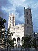
(National Historic Sites) -
[Site]: Notre-Dame-des-Neiges Cemetery
[Date(s)]: 1854 (established)
[Designated]: 1999
[Location]: Montreal45°30′6.55″N 73°36′23.48″W / 45.5018194°N 73.6065222°W / 45.5018194; -73.6065222 (Notre-Dame-des-Neiges Cemetery)
[Description]: The largest cemetery in Canada and an outstanding cultural landscape; the historical significance of many of the persons buried in the cemetery commemorates many aspects of the history of Montreal, Quebec and Canada
[Image]:
(National Historic Sites) -
[Site]: Outremont Theatre
[Date(s)]: 1929 (completed)
[Designated]: 1993
[Location]: Montreal45°31′11.77″N 73°36′30.94″W / 45.5199361°N 73.6085944°W / 45.5199361; -73.6085944 (Outremont Theatre)
[Description]: An cinema with an Art Deco exterior and a combined Art Deco and atmospheric interior; a noted example of the type of deluxe cinemas erected in new suburban neighbourhoods across Canada during the 1920s
[Image]:
(National Historic Sites) -
[Site]: Pavillon Mailloux
[Date(s)]: 1931 (completed)
[Designated]: 1997
[Location]: Montreal45°31′31.54″N 73°33′51.26″W / 45.5254278°N 73.5642389°W / 45.5254278; -73.5642389 (Pavillon Mailloux)
[Description]: A five-storey brick nurses’ residence on the campus of Montreal's Notre-Dame Hospital; construction of this purpose-built residence in 1931 symbolized the growing professionalism of nursing and the expanding role of women in health care
[Image]:
(National Historic Sites) -
[Site]: Rialto Theatre
[Date(s)]: 1924 (completed)
[Designated]: 1993
[Location]: Montreal45°31′24.91″N 73°36′17.14″W / 45.5235861°N 73.6047611°W / 45.5235861; -73.6047611 (Rialto Theatre)
[Description]: A movie palace and an exceptional example of Beaux-Arts architecture in Canada
[Image]:
(National Historic Sites) -
[Site]: Roger Gaudry Building
[Date(s)]: 1928-1943 (built)
[Designated]: 2018
[Location]: Montreal45°30′06.8″N 73°36′53.6″W / 45.501889°N 73.614889°W / 45.501889; -73.614889 (Roger Gaudry Building)
[Description]: Eclectic monumental building and tower by Ernest Cormier at the University of Montreal remains a landmark, symbol of inter-war Quebec's support for academic pursuits
[Image]:
(National Historic Sites) -
[Site]: Sainte-Anne-de-Bellevue Canal
[Date(s)]: 1843 (completed)
[Designated]: 1929
[Location]: Sainte-Anne-de-Bellevue45°24′13″N 73°57′16″W / 45.40361°N 73.95444°W / 45.40361; -73.95444 (Sainte-Anne-de-Bellevue Canal)
[Description]: A canal constructed by the Board of Works of the Province of Canada to by-pass the Ste. Anne's Rapids in the east channel of the Ottawa River; commemorates the important role played by such waterways during the 19th and 20th centuries
[Image]:
(National Historic Sites) -
[Site]: Saint Joseph's Oratory of Mount Royal
[Date(s)]: 1904 (established), 1967 (basilica completed)
[Designated]: 2003
[Location]: Montreal45°29′30″N 73°37′0″W / 45.49167°N 73.61667°W / 45.49167; -73.61667 (Saint Joseph's Oratory of Mount Royal)
[Description]: A large Roman Catholic pilgrimage site located on the north slope of Mount Royal, dominated by a landmark domed basilica; conceived by André Bessette, it has developed into a national and international religious and tourist destination
[Image]: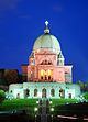
(National Historic Sites) -
[Site]: Saint-Sulpice Seminary and its Gardens
[Date(s)]: 1687 (completed)
[Designated]: 1980
[Location]: Montreal45°30′14″N 73°33′25″W / 45.50389°N 73.55694°W / 45.50389; -73.55694 (Saint-Sulpice Seminary and its Gardens)
[Description]: A religious seminary with garden; a rare and remarkable example of French Regime classicism known also for the historical integrity of its convent garden
[Image]:
(National Historic Sites) -
[Site]: Senneville Historic District
[Date(s)]: 1860 (established)
[Designated]: 2002
[Location]: Senneville45°25′50.1″N 73°57′8.2″W / 45.430583°N 73.952278°W / 45.430583; -73.952278 (Senneville Historic District)
[Description]: A 565-hectare (1,400-acre) historic district that evolved from a late-19th-century resort village which comprised the country estates of wealthy Montrealers; representative of the development of Picturesque landscape design and Arts and Crafts architecture from 1865 to 1930
[Image]:
(National Historic Sites) -
[Site]: Sir George-Étienne Cartier
[Date(s)]: 1838 (completed)
[Designated]: 1964
[Location]: Montreal45°30′40.12″N 73°33′5.84″W / 45.5111444°N 73.5516222°W / 45.5111444; -73.5516222 (Sir George-Étienne Cartier)
[Description]: Two houses that together served as the residence of Sir George-Étienne Cartier, a Father of Confederation; representative of an upper-middle class Montreal home of the mid 19th century
[Image]:
(National Historic Sites) -
[Site]: St. George Antiochian Orthodox Church
[Date(s)]: 1940 (completed)
[Designated]: 1999
[Location]: Montreal45°32′23.5″N 73°36′51.07″W / 45.539861°N 73.6141861°W / 45.539861; -73.6141861 (St. George Antiochian Orthodox Church)
[Description]: A predominantly Byzantine-style church, it is the earliest-known, purpose-built church of the Syrian Orthodox community in Canada that continues to fulfil its original role; an important symbol of the history and traditions of this community in Canada
[Image]:
(National Historic Sites) -
[Site]: St. George's Anglican Church
[Date(s)]: 1870 (completed)
[Designated]: 1990
[Location]: Montreal45°32′23.5″N 73°36′51.07″W / 45.539861°N 73.6141861°W / 45.539861; -73.6141861 (St. George's Anglican Church)
[Description]: An Anglican church in downtown Montreal that is an excellent example of the High Victorian phase of the Gothic Revival style
[Image]:
(National Historic Sites) -
[Site]: St. James United Church
[Date(s)]: 1888 (completed)
[Designated]: 1996
[Location]: Montreal45°30′18.97″N 73°34′6.56″W / 45.5052694°N 73.5684889°W / 45.5052694; -73.5684889 (St. James United Church)
[Description]: A large stone church in the High Victorian Gothic Revival style, closely associated with the late phase of Methodism in Canada; best known example in the country of an amphitheatre plan for the nave and transept and a Sunday school influenced by the Akron plan in the chancel
[Image]: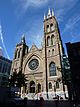
(National Historic Sites) -
[Site]: St. Patrick's Basilica
[Date(s)]: 1847 (completed)
[Designated]: 1990
[Location]: Montreal45°30′12.82″N 73°33′53.31″W / 45.5035611°N 73.5648083°W / 45.5035611; -73.5648083 (St. Patrick's Basilica)
[Description]: A noted example of French Gothic Revival architecture in the country; built to serve one of the largest early influxes of Irish immigrants to what is now Canada, the heart of the Irish population of Montreal, and the location of the funeral of Thomas D’Arcy McGee in 1868
[Image]: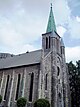
(National Historic Sites) -
[Site]: Sulpician Towers / Fort de la Montagne
[Date(s)]: 1694 (completed)
[Designated]: 1970
[Location]: Montreal45°29′37.68″N 73°35′4.56″W / 45.4938000°N 73.5846000°W / 45.4938000; -73.5846000 (Sulpician Towers / Fort de la Montagne)
[Description]: Two 13-metre (43 ft) towers that were once bastions of a fort built by François Vachon de Belmont for the Sulpicians of a nearby mission; once housed the school and nuns of Marguerite Bourgeoys
[Image]: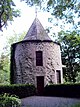
(National Historic Sites) -
[Site]: The Fur Trade at Lachine
[Date(s)]: 1803 (completed)
[Designated]: 1970
[Location]: Montreal45°25′53.04″N 73°40′32.16″W / 45.4314000°N 73.6756000°W / 45.4314000; -73.6756000 (The Fur Trade at Lachine)
[Description]: A single-storey stone warehouse located in an attractive park-like setting on the banks of the Lachine Canal; originally built by the North West Company, the warehouse symbolizes the history of the fur trade in Montreal
[Image]:
(National Historic Sites) -
[Site]: The Main
[Date(s)]:
[Designated]: 1996
[Location]: Montreal45°30′36.58″N 73°33′51.93″W / 45.5101611°N 73.5644250°W / 45.5101611; -73.5644250 (The Main)
[Description]: A 6-kilometre (3.7 mi) long stretch of Saint Laurent Boulevard where consecutive waves of immigrants settled; the merging and mixing of cultures created a character that inspired novelists, poets, singers, and film-makers
[Image]:
(National Historic Sites) -
[Site]: Trafalgar Lodge
[Date(s)]: 1848 (completed)
[Designated]: 1990
[Location]: Westmount45°29′42.36″N 73°35′53.39″W / 45.4951000°N 73.5981639°W / 45.4951000; -73.5981639 (Trafalgar Lodge)
[Description]: An asymmetrical 11⁄2-storey brick villa; a rare example of a Gothic Revival villa in Quebec
[Image]:
(National Historic Sites) -
[Site]: Van Horne / Shaughnessy House
[Date(s)]: 1848 (completed)
[Designated]: 1973
[Location]: Montreal45°29′42.36″N 73°35′53.39″W / 45.4951000°N 73.5981639°W / 45.4951000; -73.5981639 (Van Horne / Shaughnessy House)
[Description]: The Second Empire-style mansion of Thomas Shaughnessy, 1st Baron Shaughnessy, now forming part of the Canadian Centre for Architecture
[Image]:
(National Historic Sites) -
[Site]: Westmount District
[Date(s)]: 1874 (city incorporated)
[Designated]: 2012
[Location]: Westmount
[Description]: The historic district of Westmount which epitomizes the architectural styles and trends in landscape architecture of 1890 to 1930; reflects the efforts of local citizens who, from the early 20th century onwards, sought to protect the diversity and historic integrity of the district's built environment
[Image]:
(National Historic Sites) -
[Site]: Wilson Chambers
[Date(s)]: 1868 (completed)
[Designated]: 1990
[Location]: Montreal45°30′3.25″N 73°33′35.06″W / 45.5009028°N 73.5597389°W / 45.5009028; -73.5597389 (Wilson Chambers)
[Description]: A four-and-a-half-storey stone Gothic Revival style commercial building with Italianate and Second Empire influences; while many churches and institutional buildings were erected in this style in the 19th century, Gothic Revival commercial buildings were rare and this is one of the few remaining examples in Canada
[Image]:
(National Historic Sites) -
[Site]: Windsor Station (Canadian Pacific)
[Date(s)]: 1889 (completed)
[Designated]: 1975
[Location]: Montreal45°29′50.86″N 73°34′7.18″W / 45.4974611°N 73.5686611°W / 45.4974611; -73.5686611 (Windsor Station (Canadian Pacific))
[Description]: A railway terminal and Canadian Pacific Railway head office originally designed by Bruce Price; one of the earliest major buildings in Canada to use the Richardsonian Romanesque Revival style
[Image]:
(National Historic Sites)
New Random Display Display All Items(61)