


-
[Site]: Ann Baillie Building
[Date(s)]: 1904 (completed)
[Designated]: 1997
[Location]: Kingston 44°13′25.56″N 76°29′32.53″W / 44.2237667°N 76.4923694°W / 44.2237667; -76.4923694 (Ann Baillie Building)
[Description]: One of the first purpose-built nurses’ residences in Canada, the building represents the professionalization of nursing in Canada in the early 20th-century, and now serves as the Museum of Health Care
[Image]:
(National Historic Sites) -
[Site]: Bellevue House

[Date(s)]: 1841 (completed)
[Designated]: 1995
[Location]: Kingston44°13′22″N 76°30′12″W / 44.22278°N 76.50333°W / 44.22278; -76.50333 (Bellevue House)
[Description]: A noted example of Italianate architecture in the Picturesque manner in Canada, and the former residence of John A. Macdonald, a Father of Confederation and the first Prime Minister of Canada
[Image]:
(National Historic Sites) -
[Site]: Cataraqui Cemetery
[Date(s)]: 1850 (established)
[Designated]: 2011
[Location]: Kingston44°15′52″N 76°32′28″W / 44.26444°N 76.54111°W / 44.26444; -76.54111 (Cataraqui Cemetery)
[Description]: One of the best examples of a medium-sized rural or garden cemetery in Canada, containing a range of remarkable monuments, a Gothic Revival lodge, and the graves of many notable Canadians, including John A. Macdonald, the first Prime Minister (itself a NHS)
[Image]:
(National Historic Sites) -
[Site]: Elizabeth Cottage
[Date(s)]: 1843 (completed)
[Designated]: 1993
[Location]: Kingston44°13′54.46″N 76°29′20.26″W / 44.2317944°N 76.4889611°W / 44.2317944; -76.4889611 (Elizabeth Cottage)
[Description]: A representative example of a 19th-century Gothic Revival villa
[Image]:
(National Historic Sites) -
[Site]: Fort Frontenac
[Date(s)]: 1673 (original fort completed)
[Designated]: 1923
[Location]: Kingston44°14′00″N 76°28′43″W / 44.23333°N 76.47861°W / 44.23333; -76.47861 (Fort Frontenac)
[Description]: Originally a French trading post that served as a gateway to the West, the base of Robert de LaSalle’s explorations and a French outpost against the Iroquois and English forces
[Image]:
(National Historic Sites) -
[Site]: Fort Henry
[Date(s)]: 1840 (completed)
[Designated]: 1923
[Location]: Kingston44°13′48.95″N 76°27′34.85″W / 44.2302639°N 76.4596806°W / 44.2302639; -76.4596806 (Fort Henry)
[Description]: British fort that served as the principal fortification among a series of military works designed to defend Kingston, its harbour and dockyard and the entrance to the Rideau Canal
[Image]:
(National Historic Sites) -
[Site]: Frontenac County Court House
[Date(s)]: 1858 (completed)
[Designated]: 1980
[Location]: Kingston44°13′40″N 76°29′23″W / 44.227777°N 76.489777°W / 44.227777; -76.489777 (Frontenac County Court House)
[Description]: Representative of the large-scale court houses erected in Ontario after 1850, when the Municipal Act was amended to give increased power to counties to construct court houses on a monumental scale to accommodate various county functions
[Image]:
(National Historic Sites) -
[Site]: Kingston City Hall and Market Square
[Date(s)]: 1844 (completed)
[Designated]: 1961
[Location]: Kingston44°13′47.68″N 76°28′50.1″W / 44.2299111°N 76.480583°W / 44.2299111; -76.480583 (Kingston City Hall)
[Description]: A prominent example of the Neoclassical style in Canada, with a landmark tholobate and dome; its scale and design are reflective of Kingtson's status at the time of construction as capital of the Province of Canada . The Kingston Public Market, founded in 1801, is behind city hall and part of the national historic site and is the oldest public market in Ontario.
[Image]: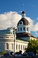
(National Historic Sites) -
[Site]: Kingston Customs House
[Date(s)]: 1859 (completed)
[Designated]: 1971
[Location]: Kingston44°13′46.64″N 76°28′56.45″W / 44.2296222°N 76.4823472°W / 44.2296222; -76.4823472 (Kingston Customs House)
[Description]: A limestone former customs house; an excellent example of the architectural quality of mid-19th-century public buildings designed in the British classical tradition
[Image]:
(National Historic Sites) -
[Site]: Kingston Dry Dock
[Date(s)]: 1892 (completed)
[Designated]: 1978
[Location]: Kingston44°13′30.63″N 76°29′0.16″W / 44.2251750°N 76.4833778°W / 44.2251750; -76.4833778 (Kingston Dry Dock)
[Description]: An important construction and repair facility for ships on the Great Lakes; noted for the Second World War naval vessels, notably corvettes, built in this dry dock
[Image]:
(National Historic Sites) -
[Site]: Kingston Fortifications
[Date(s)]: 1840 (completed)
[Designated]: 1989
[Location]: Kingston44°13′20″N 76°29′25″W / 44.222275°N 76.490357°W / 44.222275; -76.490357 (Kingston Fortifications)
[Description]: A fortification system consisting of five installations (Fort Henry NHS, Fort Frederick, Murney Tower NHS, Shoal Tower NHS and Cathcart Tower), crucial to the 19th century defense of Kingston and the terminus of the Rideau Canal
[Image]:
(National Historic Sites) -
[Site]: Kingston General Hospital
[Date(s)]: 1833-1924 (completion of historic buildings)
[Designated]: 1995
[Location]: Kingston44°13′27″N 076°29′35″W / 44.22417°N 76.49306°W / 44.22417; -76.49306 (Kingston General Hospital)
[Description]: A complex of limestone buildings, built between 1833 and 1924, set in a campus of more recent hospital buildings; the oldest public hospital in Canada still in operation, with facilities illustrative of health care in Canada in the 19th and 20th centuries
[Image]:
(National Historic Sites) -
[Site]: Kingston Navy Yard
[Date(s)]: 1788 (established)
[Designated]: 1928
[Location]: Kingston44°13′44″N 76°28′07″W / 44.22889°N 76.46861°W / 44.22889; -76.46861 (Kingston Navy Yard)
[Description]: The site of a Royal Navy Dockyard from 1788 to 1853
[Image]:
(National Historic Sites) -
[Site]: Kingston Penitentiary
[Date(s)]: 1835 (established)
[Designated]: 1990
[Location]: Kingston44°13′14″N 76°30′48″W / 44.22069°N 76.51340°W / 44.22069; -76.51340 (Kingston Penitentiary)
[Description]: Canada's oldest reformatory prison, with a layout that served as a model for other federal prisons for more than a century; its massive stone wall and north gate are an imposing local landmark
[Image]:
(National Historic Sites) -
[Site]: Murney Tower
[Date(s)]: 1846 (completed)
[Designated]: 1930
[Location]: Kingston44°13′20″N 76°29′26″W / 44.22228°N 76.490582°W / 44.22228; -76.490582 (Murney Tower)
[Description]: A martello tower located on Murray Point on the west shore of Kingston Harbour; also a component of the Kingston Fortifications National Historic Site of Canada
[Image]:
(National Historic Sites) -
[Site]: Old Kingston Post Office
[Date(s)]: 1859 (completed)
[Designated]: 1971
[Location]: Kingston44°13′47.91″N 76°28′58.89″W / 44.2299750°N 76.4830250°W / 44.2299750; -76.4830250 (Old Kingston Post Office)
[Description]: A two-storey, limestone building built in the Neoclassical style, illustrative of the popularity of neoclassical elements in the mid-19th century and the eclecticism of early Victorian architecture in Canada
[Image]:
(National Historic Sites) -
[Site]: Point Frederick Buildings
[Date(s)]:
[Designated]: 1973
[Location]: Kingston44°13′40.73″N 76°28′10.12″W / 44.2279806°N 76.4694778°W / 44.2279806; -76.4694778 (Point Frederick Buildings)
[Description]: A peninsula upon which a major British naval base was located during the War of 1812; an assemblage of architecturally significant structures used by the Royal Military College of Canada
[Image]:
(National Historic Sites) -
[Site]: Rideau Canal
[Date(s)]: 1837 (completed)
[Designated]: 1925
[Location]: Ottawa to Kingston45°25′33″N 75°41′50″W / 45.42583°N 75.69722°W / 45.42583; -75.69722 (Rideau Canal)
[Description]: Built for the British government by Lieutenant-Colonel John By as a defensive work in the event of war with the United States, the canal is the best preserved example of a 19th-century slack water canal in North America, with most of its original structures intact
[Image]:
(National Historic Sites) -
[Site]: Roselawn
[Date(s)]: 1841 (completed)
[Designated]: 1969
[Location]: Kingston44°13′31.98″N 76°30′36.66″W / 44.2255500°N 76.5101833°W / 44.2255500; -76.5101833 (Roselawn)
[Description]: A two-storey neoclassical house, now used as a conference centre by Queen's University; at one time the centre of a large estate, it is representative of the large 19th-century country houses built for affluent Kingstonians just beyond the (then) city outskirts
[Image]:
(National Historic Sites) -
[Site]: Shoal Tower
[Date(s)]: 1847 (completed)
[Designated]: 1930
[Location]: Kingston44°13′43.69″N 76°28′41.14″W / 44.2288028°N 76.4780944°W / 44.2288028; -76.4780944 (Shoal Tower)
[Description]: A martello tower located on a shoal in Kingston harbour; a component of the Kingston Fortifications NHS, and symbolic of Kingston's military and naval significance in the 19th century
[Image]:
(National Historic Sites) -
[Site]: Sir John A. Macdonald Gravesite
[Date(s)]: 1891 (burial)
[Designated]: 1938
[Location]: Kingston44°15′43″N 76°32′32″W / 44.262080°N 76.542188°W / 44.262080; -76.542188 (Sir John A. Macdonald Gravesite)
[Description]: The burial place of Sir John A. Macdonald, a Father of Confederation and the first Prime Minister of Canada, in Cataraqui Cemetery NHS
[Image]:
(National Historic Sites) -
[Site]: War of 1812 Shipwrecks
[Date(s)]: 1814 (built)
[Designated]: 2015
[Location]: Kingston44°13′52″N 76°27′08″W / 44.231003°N 76.452241°W / 44.231003; -76.452241
[Description]: Wrecks of the British ships Saint Lawrence, Princess Charlotte, and Prince Regent in Deadman Bay and elsewhere
[Image]:
(National Historic Sites)
New Random Display Display All Items(22)