


-
[Site]: Abbot Pass Refuge Cabin

[Date(s)]: 1922 (completed)
[Designated]: 1992
[Location]: Abbot Pass51°21′50.6″N 116°17′24.75″W / 51.364056°N 116.2902083°W / 51.364056; -116.2902083 (Abbot Pass Refuge Cabin)
[Description]: An alpine hut located at an elevation of 2925 metres in the Alberta Rockies, near the continental divide in Banff National Park, near its boundary with Yoho National Park in British Columbia
[Image]:
(National Historic Sites) -
[Site]: Áísínai'pi
[Date(s)]:
[Designated]: 2004
[Location]: Milk River49°4′55″N 111°37′1″W / 49.08194°N 111.61694°W / 49.08194; -111.61694 (Áísínai'pi)
[Description]: Also known as Writing-on-Stone Provincial Park, it serves as both a nature preserve and protection for a large number of aboriginal rock carvings and paintings
[Image]:
(National Historic Sites) -
[Site]: Athabasca Pass
[Date(s)]: 1811 (first documented by non-Aboriginal people)
[Designated]: 1971
[Location]: Jasper National Park52°22′35″N 118°11′00″W / 52.37639°N 118.18333°W / 52.37639; -118.18333 (Athabasca Pass)
[Description]: A major point on the fur trade route between Rupert's Land and the Columbia District, used by the York Factory Express
[Image]:
(National Historic Sites) -
[Site]: Atlas No. 3 Coal Mine
[Date(s)]: 1936 (opened)
[Designated]: 2001
[Location]: Drumheller51°19′43.07″N 112°28′57.04″W / 51.3286306°N 112.4825111°W / 51.3286306; -112.4825111 (Atlas Coal Mine)
[Description]: An exceptionally well-preserved coal-mining landscape
[Image]:
(National Historic Sites) -
[Site]: Banff Park Museum
[Date(s)]: 1903 (completed)
[Designated]: 1985
[Location]: Banff National Park51°10′25.57″N 115°34′17.9″W / 51.1737694°N 115.571639°W / 51.1737694; -115.571639 (Banff Park Museum)
[Description]: A rustic log-faced building set prominently within a landscaped park in the Banff townsite, containing early botanical and zoological exhibits from Banff National Park in early twentieth-century glass cases
[Image]:
(National Historic Sites) -
[Site]: Banff Springs Hotel
[Date(s)]: 1928 (completed)
[Designated]: 1988
[Location]: Banff National Park51°09′52.2″N 115°33′47.7″W / 51.164500°N 115.563250°W / 51.164500; -115.563250 (Banff Springs Hotel)
[Description]: A former railway hotel constructed in Scottish Baronial style at the base of Sulphur Mountain, built to replace a wooden 1888 hotel which burned down in 1926
[Image]:
(National Historic Sites) -
[Site]: Bar U Ranch
[Date(s)]: 1882 (established)
[Designated]: 1989
[Location]: Longview50°25′11″N 114°14′0″W / 50.41972°N 114.23333°W / 50.41972; -114.23333 (Bar U Ranch)
[Description]: A historic ranch in the Alberta foothills
[Image]:
(National Historic Sites) -
[Site]: Beaulieu
[Date(s)]: 1891 (completed)
[Designated]: 1992
[Location]: Calgary51°02′26″N 114°04′42″W / 51.04043°N 114.07835°W / 51.04043; -114.07835 (Beaulieu)
[Description]: Known as Lougheed House, a mansion in Calgary's Beltline district originally built for Senator James Alexander Lougheed
[Image]: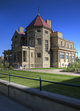
(National Historic Sites) -
[Site]: Blackfoot Crossing
[Date(s)]: 1877 (treaty)
[Designated]: 1925
[Location]: Cluny50°48′15″N 112°54′23″W / 50.80417°N 112.90639°W / 50.80417; -112.90639 (Blackfoot Crossing)
[Description]: A traditional meeting place on the Blackfoot reserve, where representations of the Crown and the Siksika, Northern Peigan, Kainai, Nakoda and Tsuu T'ina peoples met to sign Treaty 7 in 1877
[Image]:
(National Historic Sites) -
[Site]: British Block Cairn
[Date(s)]: 1400 CE (ca.)
[Designated]: 1973
[Location]: Canadian Forces Base Suffield50°36′30.24″N 110°35′32.28″W / 50.6084000°N 110.5923000°W / 50.6084000; -110.5923000 (British Block Cairn)
[Description]: A large boulder cairn surrounded by a ring of stones, an important example of Niitsitapi cultural heritage
[Image]: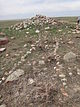
(National Historic Sites) -
[Site]: Brooks Aqueduct
[Date(s)]: 1914 (completed)
[Designated]: 1983
[Location]: Brooks50°31′44.04″N 111°51′18″W / 50.5289000°N 111.85500°W / 50.5289000; -111.85500 (Brooks Aqueduct)
[Description]: A landmark irrigation project built by the Canadian Pacific Railway, spanning a 3.2 kilometer valley and irrigating a section of south-eastern Alberta
[Image]:
(National Historic Sites) -
[Site]: Calgary City Hall
[Date(s)]: 1911 (completed)
[Designated]: 1984
[Location]: Calgary51°2′46″N 114°3′26″W / 51.04611°N 114.05722°W / 51.04611; -114.05722 (Calgary City Hall)
[Description]: A four-storey sandstone building with central clock tower, designed in the Romanesque Revival style and serving as the focal point of Calgary's city hall complex
[Image]:
(National Historic Sites) -
[Site]: Cave and Basin
[Date(s)]: 1859 (first documented by non-Aboriginal people)
[Designated]: 1981
[Location]: Banff National Park51°10′12″N 115°35′20.76″W / 51.17000°N 115.5891000°W / 51.17000; -115.5891000 (Cave and Basin)
[Description]: The site of natural thermal mineral springs around which Canada's first national park, Banff National Park, was established
[Image]:
(National Historic Sites) -
[Site]: Central Memorial Library and Park
[Date(s)]: 1889
[Designated]: 2018
[Location]: Calgary51°02′28.1″N 114°04′14.9″W / 51.041139°N 114.070806°W / 51.041139; -114.070806 (Central Memorial Park)
[Description]: Formal gardens with memorials and a striking Carnegie library; symbol of quest for an attractive, cultured new city in the West
[Image]:
(National Historic Sites) -
[Site]: Coleman
[Date(s)]: 1903 (establishment of townsite)
[Designated]: 2001
[Location]: Crowsnest Pass (municipality)49°38′7″N 114°30′11″W / 49.63528°N 114.50306°W / 49.63528; -114.50306 (Coleman)
[Description]: A preserved coal-mining landscape in one of the most important coal producing centres in the Crowsnest Pass, the greatest coalfield in Alberta and southeastern British Columbia
[Image]:
(National Historic Sites) -
[Site]: Earthlodge Village
[Date(s)]: 1740 (c.)
[Designated]: 1972
[Location]: Gleichen50°47′4″N 112°51′25″W / 50.78444°N 112.85694°W / 50.78444; -112.85694 (Earthlodge Village)
[Description]: Earthwork defensive fortifications, unique in Canada, constructed by an unidentified people
[Image]:
(National Historic Sites) -
[Site]: First Oil Well in Western Canada
[Date(s)]: 1902
[Designated]: 1965
[Location]: Waterton Lakes National Park49°4′15.53″N 113°59′12.37″W / 49.0709806°N 113.9867694°W / 49.0709806; -113.9867694 (First Oil Well in Western Canada)
[Description]: First commercially productive oil well in Western Canada
[Image]:
(National Historic Sites) -
[Site]: Fort Assiniboine
[Date(s)]: 1823 (fort established)
[Designated]: 1935
[Location]: Woodlands County54°20′1″N 114°46′19″W / 54.33361°N 114.77194°W / 54.33361; -114.77194 (Fort Assiniboine)
[Description]: A trading post established by the Hudson's Bay Company which served as a stopping point along the Klondike Trail
[Image]:
(National Historic Sites) -
[Site]: Fort Augustus and Fort Edmonton
[Date(s)]: 1795 (Fort Augustus built), 1796 (first Fort Edmonton built)
[Designated]: 1923
[Location]: Fort Saskatchewan53°42′58″N 113°13′15″W / 53.71611°N 113.22083°W / 53.71611; -113.22083 (Fort Augustus and Fort Edmonton)
[Description]: The site of rival trading posts established by the North West Company and the Hudson's Bay Company, described as being a "musket-shot" apart
[Image]:
(National Historic Sites) -
[Site]: Fort Calgary
[Date(s)]: 1875 (established)
[Designated]: 1925
[Location]: Calgary51°2′43″N 114°2′45″W / 51.04528°N 114.04583°W / 51.04528; -114.04583 (Fort Calgary)
[Description]: A fort established by the North-West Mounted Police, located at the confluence of the Bow and Elbow rivers in what is now Calgary
[Image]:
(National Historic Sites) -
[Site]: Fort Chipewyan
[Date(s)]: 1788 (established)
[Designated]: 1930
[Location]: Wood Buffalo58°42′44″N 111°08′54″W / 58.71222°N 111.14833°W / 58.71222; -111.14833 (Fort Chipewyan)
[Description]: One of the oldest European settlements in Alberta, established by the North West Company when it built a trading post there in 1788
[Image]:
(National Historic Sites) -
[Site]: Fort Dunvegan
[Date(s)]: 1805 (established)
[Designated]: 1947
[Location]: Dunvegan55°55′25″N 118°35′40″W / 55.92361°N 118.59444°W / 55.92361; -118.59444 (Fort Dunvegan)
[Description]: Site of a trading post established by the North West Company
[Image]:
(National Historic Sites) -
[Site]: Fort Edmonton III
[Date(s)]: 1830 (established)
[Designated]: 1959
[Location]: Edmonton53°32′1.37″N 113°30′23.51″W / 53.5337139°N 113.5065306°W / 53.5337139; -113.5065306 (Fort Edmonton III)
[Description]: The final Hudson's Bay Company fort to bear the "Fort Edmonton" name, evolved into present-day Edmonton; reconstructed commencing in 1969
[Image]:
(National Historic Sites) -
[Site]: Fort Fork
[Date(s)]: 1792 (established)
[Designated]: 1928
[Location]: Peace River56°8′15″N 117°28′30″W / 56.13750°N 117.47500°W / 56.13750; -117.47500 (Fort Fork)
[Description]: Starting point of Alexander MacKenzie's route to Pacific, 1793
[Image]:
(National Historic Sites) -
[Site]: Fort Macleod
[Date(s)]: 1874 (established)
[Designated]: 1923
[Location]: Fort Macleod49°43′32.1″N 113°23′51.1″W / 49.725583°N 113.397528°W / 49.725583; -113.397528 (Fort Macleod)
[Description]: A fort established in 1874 on an island on the Oldman River, it was the first outpost of the North-West Mounted Police in Western Canada, and served as NWMP headquarters between 1874 and 1878
[Image]:
(National Historic Sites) -
[Site]: Fort Vermilion
[Date(s)]: 1788 (first fort established), 1828 (fort moved), 1908 (Old Bay House completed)
[Designated]: 1968
[Location]: Fort Vermilion58°23′4″N 116°2′26″W / 58.38444°N 116.04056°W / 58.38444; -116.04056 (Fort Vermilion)
[Description]: The "Old Bay House" is the only Hudson’s Bay Company factor’s house on its original location in Alberta, the last remaining structure of the fort that evolved into the present-day hamlet of Fort Vermilion
[Image]:
(National Historic Sites) -
[Site]: Fort Whoop-Up
[Date(s)]: 1870 (established)
[Designated]: 1963
[Location]: Lethbridge49°41′31″N 112°51′24″W / 49.69194°N 112.85667°W / 49.69194; -112.85667 (Fort Whoop-Up)
[Description]: Originally named Fort Hamilton, the Fort Whoop-Up trading post became the centre of the illegal whisky trade in the region, contributing to the formation of the North-West Mounted Police in 1874 to police Canada's western territories
[Image]:
(National Historic Sites) -
[Site]: Frog Lake
[Date(s)]: 1885 (uprising)
[Designated]: 1923
[Location]: Frog Lake53°49′52″N 110°21′31″W / 53.831186°N 110.358696°W / 53.831186; -110.358696 (Frog Lake)
[Description]: Site of the Frog Lake Massacre, a Cree uprising during the North-West Rebellion prompted by what seemed to be unfair treaties by the Canadian government and the dwindling buffalo population
[Image]:
(National Historic Sites) -
[Site]: Government House in Edmonton, Alberta
[Date(s)]: 1911 (completed)
[Designated]: 2012
[Location]: Edmonton53°32′29.88″N 113°32′38.1″W / 53.5416333°N 113.543917°W / 53.5416333; -113.543917 (Government House in Edmonton, Alberta)
[Description]: Served as official residence of Alberta's first six Lieutenant Governors; its imposing exterior, prominent location and distinctive architecture symbolize Alberta's new provincial status and Edmonton’s new role as capital in the early 20th century
[Image]:
(National Historic Sites) -
[Site]: Head-Smashed-In Buffalo Jump
[Date(s)]: 3500 BCE (ca.) (usage began), 1880s (first documented by non-Aboriginal people)
[Designated]: 1968
[Location]: Municipal District of Willow Creek No. 2649°42′0″N 113°38′0″W / 49.70000°N 113.63333°W / 49.70000; -113.63333 (Head-Smashed-In Buffalo Jump)
[Description]: A buffalo jump located where the foothills of the Rocky Mountains begin to rise from the prairie, used for 5,500 years by the indigenous peoples of the plains to kill buffalo by driving them off the 11-metre-high cliff (A UNESCO World Heritage Site)
[Image]:
(National Historic Sites) -
[Site]: Heritage Hall - Southern Alberta Institute of Technology
[Date(s)]: 1922 (completed)
[Designated]: 1987
[Location]: Calgary51°03′43″N 114°05′29″W / 51.06194°N 114.09139°W / 51.06194; -114.09139 (Heritage Hall)
[Description]: A three-storey educational building prominently situated on the brow of the Bow River valley, constructed in the Collegiate Gothic style, representative of the growth of post-secondary educational institutions in Canada in the early twentieth century
[Image]:
(National Historic Sites) -
[Site]: Howse Pass
[Date(s)]: 1807 (first European exploration)
[Designated]: 1978
[Location]: Blaeberry River and Banff National Park51°48′53.53″N 116°46′20.31″W / 51.8148694°N 116.7723083°W / 51.8148694; -116.7723083 (Howse Pass)
[Description]: An early nineteenth-century transportation route through the Canadian Rockies
[Image]:
(National Historic Sites) -
[Site]: Jasper House
[Date(s)]: 1830 (completed)
[Designated]: 1924
[Location]: Jasper National Park53°8′48.51″N 117°59′3.1″W / 53.1468083°N 117.984194°W / 53.1468083; -117.984194 (Jasper House)
[Description]: Archaeological remains of a fur trade post that served as a major destination for travellers using the Athabasca and the Yellowhead passes and the First Nations route through the Smoky River Pass.
[Image]:
(National Historic Sites) -
[Site]: Jasper Park Information Centre
[Date(s)]: 1914 (completed)
[Designated]: 1992
[Location]: Jasper National Park52°52′38.32″N 118°4′51.01″W / 52.8773111°N 118.0808361°W / 52.8773111; -118.0808361 (Jasper Park Information Centre)
[Description]: A rustic fieldstone park building, symbolic of early architecture within Canada's national parks
[Image]:
(National Historic Sites) -
[Site]: Lac Ste. Anne Pilgrimage
[Date(s)]: 1889 (established)
[Designated]: 1984
[Location]: Lac Ste. Anne County53°42′40″N 114°23′49″W / 53.71111°N 114.39694°W / 53.71111; -114.39694 (Lac Ste. Anne Pilgrimage)
[Description]: First Roman Catholic mission to be established by the renowned priest, Albert Lacombe
[Image]:
(National Historic Sites) -
[Site]: Leduc-Woodbend Oilfield
[Date(s)]: 1946 (established)
[Designated]: 1990
[Location]: Leduc53°19′46.45″N 113°43′31.01″W / 53.3295694°N 113.7252806°W / 53.3295694; -113.7252806 (Leduc No 1 Historic Site)
[Description]: Site of a major crude oil discovery in Alberta, which led to the post-World War II boom in petroleum exploration and development in Western Canada
[Image]: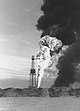
(National Historic Sites) -
[Site]: Maligne Lake Chalet and Guest House
[Date(s)]: 1935 (built)
[Designated]: 2015
[Location]: Jasper National Park52°43′47″N 117°38′23″W / 52.729652°N 117.639632°W / 52.729652; -117.639632
[Description]: Rustic lodge evokes early mountain tourism and the role of guides, outfitters and railroads in the development of national parks
[Image]:
(National Historic Sites) -
[Site]: Medalta Potteries
[Date(s)]: 1912 (established)
[Designated]: 1985
[Location]: Medicine Hat50°1′55″N 110°38′58″W / 50.03194°N 110.64944°W / 50.03194; -110.64944 (Medalta Potteries)
[Description]: Early twentieth century beehive kilns and manufacturing buildings; the first western Canadian manufacturer to ship goods east of the Great Lakes
[Image]:
(National Historic Sites) -
[Site]: Medicine Hat Clay Industries
[Date(s)]:
[Designated]: 1999
[Location]: Medicine Hat50°1′53″N 110°39′3″W / 50.03139°N 110.65083°W / 50.03139; -110.65083 (Medicine Hat Clay Industries)
[Description]: A cultural landscape illustrating the factors (local clay beds, access to railway transportation, vast supplies of natural gas to fire the kilns) that led to Medicine Hat’s emergence as the largest supplier of clay products west of Ontario
[Image]:
(National Historic Sites) -
[Site]: Mewata Drill Hall / Calgary Drill Hall
[Date(s)]: 1918 (completed)
[Designated]: 1989
[Location]: Calgary51°02′45″N 114°05′20″W / 51.04583°N 114.08889°W / 51.04583; -114.08889 (Mewata Armouries)
[Description]: A large-scale drill hall, the scale and prominent location of which exemplify the national pride that greeted Canada's strong performance in the South African War and the First World War
[Image]:
(National Historic Sites) -
[Site]: Nordegg
[Date(s)]: 1911 (mine established)
[Designated]: 2001
[Location]: Nordegg52°28′30″N 116°4′24″W / 52.47500°N 116.07333°W / 52.47500; -116.07333 (Nordegg)
[Description]: An important coal mining landscape, with many mining and related resources still existing on site
[Image]:
(National Historic Sites) -
[Site]: Notre Dame des Victoires / Lac La Biche Mission
[Date(s)]: 1853 (established)
[Designated]: 1989
[Location]: Lac La Biche54°49′15″N 112°5′44″W / 54.82083°N 112.09556°W / 54.82083; -112.09556 (Notre Dame des Victoires / Lac La Biche Mission)
[Description]: An important Roman Catholic mission, established by the Oblates of Mary Immaculate, which served as the hub of various portage routes
[Image]:
(National Historic Sites) -
[Site]: Old Women's Buffalo Jump
[Date(s)]:
[Designated]: 1960
[Location]: Cayley
[Description]: An aboriginal bison drive in use for more than 1500 years
[Image]:
(National Historic Sites) -
[Site]: Palace Theatre
[Date(s)]: 1921 (completed)
[Designated]: 1996
[Location]: Calgary
[Description]: A movie palace designed by internationally renowned theatre architect C. Howard Crane, and one of four surviving movie theatres in Canada built by the Allen Chain
[Image]:
(National Historic Sites) -
[Site]: Prince of Wales Hotel
[Date(s)]: 1927 (completed)
[Designated]: 1992
[Location]: Waterton Lakes National Park49°03′32″N 113°54′13″W / 49.05889°N 113.90361°W / 49.05889; -113.90361 (Prince of Wales Hotel)
[Description]: A landmark hotel constructed in the rustic-design style, representing the golden age of railway resort development in Canada's national parks
[Image]:
(National Historic Sites) -
[Site]: Reader Rock Garden
[Date(s)]: 1913 (begun)
[Designated]: 2018
[Location]: Calgary51°01′48″N 114°03′18″W / 51.0299°N 114.055°W / 51.0299; -114.055 (Reader Rock Garden)
[Description]: Scientific and aesthetic horticultural garden
[Image]:
(National Historic Sites) -
[Site]: Rocky Mountain House
[Date(s)]: 1799 (established)
[Designated]: 1926
[Location]: Rocky Mountain House, Alberta52°21′41″N 114°58′14″W / 52.361495°N 114.970471°W / 52.361495; -114.970471 (Rocky Mountain House)
[Description]: An archaeological site that contains the remains of several early 19th-century fur trade forts known by the names of Rocky Mountain House (established by the North West Company) and Acton House (established by the Hudson's Bay Company)
[Image]:
(National Historic Sites) -
[Site]: Rundle's Mission
[Date(s)]: 1847 (established)
[Designated]: 1963
[Location]: Pigeon Lake53°01′30″N 114°04′01″W / 53.025°N 114.067°W / 53.025; -114.067 (Rundle's Mission)
[Description]: The site of the first Protestant mission in the Canadian Prairies
[Image]:
(National Historic Sites) -
[Site]: Skoki Ski Lodge
[Date(s)]: 1936 (completed)
[Designated]: 1992
[Location]: Banff National Park51°31′23″N 116°04′35″W / 51.52306°N 116.07639°W / 51.52306; -116.07639 (Skoki Ski Lodge)
[Description]: A rustic ski lodge resort, representing the early visual identity of Canada's mountain parks and of the early days of tourism in Banff National Park
[Image]:
(National Historic Sites) -
[Site]: St. Patrick's Roman Catholic Church
[Date(s)]: 1914 (completed)
[Designated]: 1990
[Location]: Medicine Hat50°2′43″N 110°40′50″W / 50.04528°N 110.68056°W / 50.04528; -110.68056 (St. Patrick's Roman Catholic Church)
[Description]: A noted example of Gothic Revival architecture in Alberta
[Image]:
(National Historic Sites) -
[Site]: Stephen Avenue
[Date(s)]: 1880 (established)
[Designated]: 2002
[Location]: Calgary51°02′44″N 114°03′47″W / 51.0456°N 114.0630°W / 51.0456; -114.0630 (Stephen Avenue)
[Description]: A late-nineteenth-century retail streetscape in downtown Calgary
[Image]:
(National Historic Sites) -
[Site]: Stirling Agricultural Village
[Date(s)]: 1899 (established)
[Designated]: 1997
[Location]: Stirling
[Description]: The best surviving example of a Mormon agricultural village in Canada, following the Plat of Zion model
[Image]: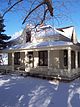
(National Historic Sites) -
[Site]: Suffield Tipi Rings
[Date(s)]:
[Designated]: 1973
[Location]: Cypress County
[Description]: Various sets of archaeological remains relating to the cultural occupations by the Niitsitapi, featuring tipi rings, medicine wheels and other rock arrangements
[Image]:
(National Historic Sites) -
[Site]: Sulphur Mountain Cosmic Ray Station
[Date(s)]: 1957 (completed)
[Designated]: 1982
[Location]: Banff National Park51°07′25″N 115°33′20″W / 51.12361°N 115.55556°W / 51.12361; -115.55556 (Sulphur Mountain)
[Description]: Canada’s most important cosmic ray observatory from the 1950s
[Image]:
(National Historic Sites) -
[Site]: Temple of the Church of Jesus Christ of Latter Day Saints
[Date(s)]: 1923 (completed)
[Designated]: 1992
[Location]: Cardston
[Description]: A monumental modern temple in historic Mormon centre
[Image]:
(National Historic Sites) -
[Site]: Territorial Court House
[Date(s)]: 1904 (completed)
[Designated]: 1980
[Location]: Fort Macleod
[Description]: The oldest court house in Alberta and one of the few buildings surviving from the period of Territorial administration of the Canadian Prairies
[Image]:
(National Historic Sites) -
[Site]: Treaty Nº 7 Signing Site
[Date(s)]: 1877 (treaty signed)
[Designated]: 1925
[Location]: Wheatland County
[Description]: The site where representatives of the Siksika, Pekuni, Kainai, Nakoda and Tsuu T’ina peoples met with representatives of the Crown to sign Treaty No. 7 in September 1877
[Image]:
(National Historic Sites) -
[Site]: Turner Valley Gas Plant
[Date(s)]: 1914 (established)
[Designated]: 1995
[Location]: Turner Valley
[Description]: A petroleum industrial complex comprising 22 metal buildings and related infrastructure, and the site of two early gas wells that established the Turner Valley as the most important oil field in Alberta
[Image]:
(National Historic Sites) -
[Site]: Turner Valley Oilfield
[Date(s)]: 1914 (established)
[Designated]: 1990
[Location]: Turner Valley
[Description]: The first major oil field in Alberta
[Image]:
(National Historic Sites) -
[Site]: Victoria Settlement
[Date(s)]: 1863 (established)
[Designated]: 2001
[Location]: Smoky Lake
[Description]: A cultural landscape illustrating major themes in the development of the Canadian Prairies, including the rise of the fur trade, the establishment of the Métis river lot system, the arrival of missions, prairie agricultural development and the arrival of eastern European immigrants
[Image]:
(National Historic Sites) -
[Site]: Wetaskiwin Court House
[Date(s)]: 1909 (completed)
[Designated]: 1980
[Location]: Wetaskiwin
[Description]: A court house symbolic of the rapid growth of the justice system in Alberta, typifying court house design during this formative period in the growth of western Canada
[Image]:
(National Historic Sites) -
[Site]: Yellowhead Pass
[Date(s)]:
[Designated]: 1971
[Location]: Jasper National Park52°53′33″N 118°27′50″W / 52.89250°N 118.46389°W / 52.89250; -118.46389 (Yellowhead Pass)
[Description]: An important transportation route through the Canadian Rockies
[Image]:
(National Historic Sites)
New Random Display Display All Items(62)