


-
[Name]: Byron Cemetery
[Image]:
[Location]: 306 Hamilton, Byron, MI 48418
[City]: Burns Township
[Listing date]: February 29, 1996
(Current listings) -
[Name]: Byron Informational Designation
[Image]: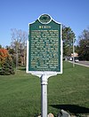
[Location]: 312 West Maple Street
[City]: Byron
[Listing date]: July 26, 1974
(Current listings) -
[Name]: Charles H. Calkins House†
[Image]: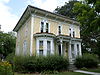
[Location]: 127 East First Street
[City]: Perry
[Listing date]: February 7, 1977
(Current listings) -
[Name]: Capitol Theatre
[Image]:
[Location]: 122 East Main Street
[City]: Owosso
[Listing date]: December 5, 1986
(Current listings) -
[Name]: Frederick Chavannes House
[Image]:
[Location]: 12454 M-52
[City]: Perry
[Listing date]: December 5, 1996
(Current listings) -
[Name]: Coal Creek Vein Informational Site
[Image]:
[Location]: M-21, east of State Road near Michigan Brick Company
[City]: Corunna vicinity
[Listing date]: October 23, 1987
(Current listings) -
[Name]: Elias Comstock Cabin†
[Image]:
[Location]: Curwood Castle Drive and John Street
[City]: Owosso
[Listing date]: January 18, 1980
(Current listings) -
[Name]: Congregational Church of Perry
[Image]:
[Location]: 130 East Second Street
[City]: Perry
[Listing date]: February 10, 1983
(Current listings) -
[Name]: Corunna Public Schools / Shiawassee Street School
[Image]:
[Location]: 106 South Shiawassee Street
[City]: Corunna
[Listing date]: April 25, 1988
(Current listings) -
[Name]: Curwood Castle†
[Image]:
[Location]: 224 John Street
[City]: Owosso
[Listing date]: April 24, 1970
(Current listings) -
[Name]: Thomas E. Dewey Boyhood Home
[Image]:
[Location]: 421 West Oliver
[City]: Owosso
[Listing date]: December 10, 1971
(Current listings) -
[Name]: Birthplace of Thomas Edmund Dewey (Demolished)
[Image]:
[Location]: 313 West Main Street
[City]: Owosso
[Listing date]: February 11, 1972
(Current listings) -
[Name]: First Congregational Church and Society
[Image]: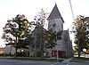
[Location]: 327 North Washington Street
[City]: Owosso
[Listing date]: January 17, 1991
(Current listings) -
[Name]: First Congregational Church
[Image]: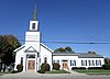
[Location]: 401 East Grand River Road
[City]: Laingsburg
[Listing date]: March 15, 1990
(Current listings) -
[Name]: First National Bank of Corunna
[Image]:
[Location]: 201 North Shiawassee Street
[City]: Corunna
[Listing date]: April 29, 1982
(Current listings) -
[Name]: Herman C. Frieseke House† / Frederick Carl Frieseke Informational Designation
[Image]:
[Location]: 654 North Water Street
[City]: Owosso
[Listing date]: June 10, 1987
(Current listings) -
[Name]: Julius Frieseke House†
[Image]: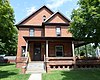
[Location]: 529 Corunna Avenue
[City]: Owosso
[Listing date]: April 23, 1985
(Current listings) -
[Name]: Durand Union Station†
[Image]:
[Location]: 200 Railroad Street
[City]: Durand
[Listing date]: November 6, 1970
(Current listings) -
[Name]: John N. Ingersoll House†
[Image]: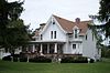
[Location]: 570 West Corunna Avenue
[City]: Corunna
[Listing date]: February 11, 1972
(Current listings) -
[Name]: Judd's Corners Informational Designation
[Image]:
[Location]: 9000 Juddville Road, SE corner of Durand Road
[City]: Corunna
[Listing date]: June 15, 1992
(Current listings) -
[Name]: Knaggs Bridge Area Informational Site (marker stolen)
[Image]: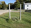
[Location]: Cole Road at the Shiawassee River, 3 miles southeast of Bancroft
[City]: Bancroft
[Listing date]: April 11, 1963
(Current listings) -
[Name]: Knights Templar Special Informational Designation
[Image]:
[Location]: Iron Horse Park, 205 West Clinton Street
[City]: Durand
[Listing date]: May 8, 1986
(Current listings) -
[Name]: Maple River Area
[Image]:
[Location]: 540-1151 East Bennington and 5210 Colby Road
[City]: Owosso vicinity
[Listing date]: April 4, 1978
(Current listings) -
[Name]: Martin Road Bridge†
[Image]:
[Location]: Martin Road at the Shiawassee River
[City]: Caledonia Township
[Listing date]: June 21, 1990
(Current listings) -
[Name]: Hugh McCurdy / Hugh McCurdy Park Informational Site
[Image]:
[Location]: West Corunna Avenue at Governor Parsons Drive
[City]: Corunna
[Listing date]: March 15, 1990
(Current listings) -
[Name]: Methodist Episcopal Church
[Image]:
[Location]: 101 South Beach Street
[City]: Bancroft
[Listing date]: April 21, 1980
(Current listings) -
[Name]: Methodist Episcopal Church (Burned)
[Image]:
[Location]: 7495 Orchard
[City]: New Lothrop
[Listing date]: September 7, 1989
(Current listings) -
[Name]: Governor Andrew Parsons House
[Image]:
[Location]: 318 McNeil Street
[City]: Corunna
[Listing date]: June 27, 1969
(Current listings) -
[Name]: Old Perry Centre Informational Designation
[Image]: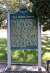
[Location]: M-52 at the junction of Ellsworth Road
[City]: Perry
[Listing date]: March 19, 1987
(Current listings) -
[Name]: Perry District No. 4 School
[Image]:
[Location]: Roselawn Cemetery, 1864 West Ellsworth Road
[City]: Perry
[Listing date]: January 23, 1992
(Current listings) -
[Name]: Saint Mary's Church
[Image]:
[Location]: 509 Main Street
[City]: Morrice
[Listing date]: September 24, 1992
(Current listings) -
[Name]: Shiawassee Conservation Association Clubhouse
[Image]:
[Location]: 4247 North M-52
[City]: Owosso
[Listing date]: September 26, 1987
(Current listings) -
[Name]: Shiawassee County Courthouse†
[Image]: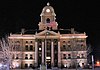
[Location]: 218 N Shiawassee Avenue (M-71)
[City]: Corunna
[Listing date]: November 14, 1974
(Current listings) -
[Name]: South Side School
[Image]:
[Location]: 405 South Oak Street
[City]: Durand
[Listing date]: July 26, 1978
(Current listings) -
[Name]: Ellen May Tower Informational Designation
[Image]:
[Location]: 312 West Maple Street
[City]: Byron
[Listing date]: January 19, 1989
(Current listings) -
[Name]: Andrew J. Van Riper House
[Image]:
[Location]: 7480 West Beard Road
[City]: Perry vicinity
[Listing date]: January 22, 1987
(Current listings)
New Random Display Display All Items(36)