


-
[Name]: Wallace Allen House
[Image]:
[Location]: 303 N Port Crescent
[City]: Bad Axe
[Listing date]: November 15, 1990
(Current listings) -
[Name]: Bay Port Commercial Fishing Historic District†
[Image]:
[Location]: Off M-25 (Marker at 1008 1st Street)
[City]: Bay Port
[Listing date]: February 21, 1975
(Current listings) -
[Name]: Caseville Methodist Episcopal Church
[Image]:
[Location]: 6490 Main Street
[City]: Caseville
[Listing date]: March 15, 1990
(Current listings) -
[Name]: Citizens Bank Block
[Image]:
[Location]: 2236 Main Street
[City]: Ubly
[Listing date]: March 18, 1998
(Current listings) -
[Name]: Great Fire of 1881 Informational Designation
[Image]:
[Location]: Roadside Park on M-25, 1/2 mile South of Junction M-25 and M-142
[City]: Bay Port
[Listing date]: January 19, 1957
(Current listings) -
[Name]: James and Jane Grice House†
[Image]:
[Location]: 865 North Huron Avenue
[City]: Harbor Beach
[Listing date]: November 3, 1976
(Current listings) -
[Name]: Grindstone City Historic District†
[Image]:
[Location]: On US-25, five miles east of Port Austin
[City]: Grindstone City
[Listing date]: September 25, 1956
(Current listings) -
[Name]: Huron City Historic District†
[Image]:
[Location]: Pioneer Drive
[City]: Port Austin
[Listing date]: August 6, 1976
(Current listings) -
[Name]: Huron House
[Image]:
[Location]: 113 South Huron Street
[City]: Harbor Beach
[Listing date]: April 18, 1983
(Current listings) -
[Name]: Indian Mission†
[Image]:
[Location]: 590 East Bay Street
[City]: Sebewaing vicinity
[Listing date]: July 19, 1962
(Current listings) -
[Name]: Jewish Colony (Demolished)
[Image]:
[Location]: 16 N, 13 E, 5 miles NE of Bad Axe
[City]: Verona Township
[Listing date]: February 11, 1972
(Current listings) -
[Name]: Charles G. Learned House†
[Image]:
[Location]: 8544 Lake Street
[City]: Port Austin
[Listing date]: June 10, 1980
(Current listings) -
[Name]: Frank Murphy Birthplace†
[Image]:
[Location]: 142 South Huron Street
[City]: Harbor Beach
[Listing date]: February 17, 1967
(Current listings) -
[Name]: Owendale Informational Designation
[Image]:
[Location]: Village Park
[City]: Owendale
[Listing date]: April 4, 1975
(Current listings) -
[Name]: Parisville Poles Informational Designation
[Image]:
[Location]: 4190 Parisville Road
[City]: Parisville vicinity
[Listing date]: February 7, 1977
(Current listings) -
[Name]: Pigeon Depot
[Image]:
[Location]: 59 South Main
[City]: Pigeon
[Listing date]: August 21, 1987
(Current listings) -
[Name]: Pointe Aux Barques Lighthouse†
[Image]: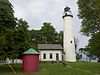
[Location]: Pointe Aux Barques, east of Huron City on Light House Road
[City]: Huron City vicinity
[Listing date]: February 11, 1972
(Current listings) -
[Name]: Port Crescent Ghost Town
[Image]:
[Location]: Port Crescent State Park, M-25 at Port Crescent Road
[City]: Port Austin vicinity
[Listing date]: January 18, 1963
(Current listings) -
[Name]: Saginaw, Tuscola and Huron Railroad Elkton Depot
[Image]:
[Location]: 76 North Main Street
[City]: Elkton
[Listing date]: August 22, 1985
(Current listings) -
[Name]: Saint Mary of Czestochowa Roman Catholic Church
[Image]:
[Location]: Moeller Road east of Hellems Road
[City]: Dwight Township
[Listing date]: November 2, 1980
(Current listings) -
[Name]: Saint Michael's Church
[Image]:
[Location]: Independence Street
[City]: Port Austin
[Listing date]: December 10, 1971
(Current listings) -
[Name]: Sebewaing Township Hall
[Image]:
[Location]: 92 South Center
[City]: Sebewaing
[Listing date]: November 1, 1988
(Current listings) -
[Name]: Albert E. Sleeper House†
[Image]:
[Location]: 302 West Huron Avenue
[City]: Bad Axe
[Listing date]: April 23, 1971
(Current listings) -
[Name]: W. R. Stafford House†
[Image]: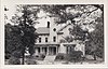
[Location]: 4467 Main Street
[City]: Port Hope
[Listing date]: December 10, 1971
(Current listings) -
[Name]: W. R. Stafford Saw Mill Site†
[Image]:
[Location]: Huron Street; Stafford Park, near M-25
[City]: Port Hope
[Listing date]: July 17, 1961
(Current listings) -
[Name]: Stagecoach Travel in Michigan Informational Designation
[Image]:
[Location]: Cedar Street
[City]: Bay Port
[Listing date]: August 12, 1977
(Current listings) -
[Name]: White Rock School
[Image]: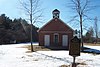
[Location]: Highway M-25
[City]: White Rock vicinity
[Listing date]: April 14, 1972
(Current listings) -
[Name]: White Rock Treaty of 1807 Boundary Marker
[Image]:
[Location]: 1/4 mile off shore in Lake Huron, visible from the intersection of M-25 and Atwater Road
[City]:
[Listing date]: February 18, 1956
(Current listings) -
[Name]: Winsor and Snover Bank Building†
[Image]:
[Location]: 8648 Lake Street
[City]: Port Austin
[Listing date]: January 27, 1983
(Current listings) -
[Name]: Woldt Brothers General Store
[Image]:
[Location]: 9503 Bach Road
[City]: Sebewaing
[Listing date]: February 25, 1988
(Current listings)
New Random Display Display All Items(30)