


-
[HCM #]: 10
[Landmark name]: Eagle Rock
[Image]:
[Date designated]: November 16, 1962
[Locality]: Terminus of N. Figueroa St.34°8′36″N 118°11′01″W / 34.14333°N 118.18361°W / 34.14333; -118.18361 (10. Eagle Rock)
[Neighborhood]: Eagle Rock
[Description]: Large outcropping of rock, with an overhang which produces a shadow that looks like an eagle in flight under certain lighting conditions.
(Current and former Historic-Cultural Monuments) -
[HCM #]: 22
[Landmark name]: Palms-Southern Pacific Railroad Depot
[Image]:
[Date designated]: August 9, 1963
[Locality]: 3800 Homer Street34°5′18″N 118°12′29″W / 34.08833°N 118.20806°W / 34.08833; -118.20806 (22. Palms-Southern Pacific Railroad Depot)
[Neighborhood]: Montecito Heights
[Description]: Rail depot built c. 1887 in Palms, became part of the Pacific Electric Railway in 1911; relocated to Heritage Square
(Current and former Historic-Cultural Monuments) -
[HCM #]: 40
[Landmark name]: Hale House
[Image]:
[Date designated]: June 15, 1966
[Locality]: 3800 Homer St.34°5′18″N 118°12′28″W / 34.08833°N 118.20778°W / 34.08833; -118.20778 (40. Hale House)
[Neighborhood]: Montecito Heights
[Description]: Colorful Victorian house called the most photographed house in Los Angeles; moved to Heritage Square Museum in 1970
(Current and former Historic-Cultural Monuments) -
[HCM #]: 42
[Landmark name]: San Antonio Winery
[Image]:
[Date designated]: September 14, 1966
[Locality]: 737 Lamar St.34°3′50″N 118°13′25″W / 34.06389°N 118.22361°W / 34.06389; -118.22361 (42. San Antonio Winery)
[Neighborhood]: Lincoln Heights
[Description]: Winery founded in 1917; the last remaining winery in the city of Los Angeles.
(Current and former Historic-Cultural Monuments) -
[HCM #]: 54
[Landmark name]: Old 6th Street Wooden Bridge
[Image]:
[Date designated]: May 22, 1968
[Locality]: Hollenbeck Park Lake34°2′26″N 118°13′03″W / 34.04056°N 118.21750°W / 34.04056; -118.21750 (54. Old 6th Street Wooden Bridge (site of))
[Neighborhood]: Boyle Heights
[Description]: Bridge demolished in 1968
(Current and former Historic-Cultural Monuments) -
[HCM #]: 59
[Landmark name]: Eagle Rock City Hall
[Image]:
[Date designated]: February 26, 1969
[Locality]: 2035 Colorado Blvd.34°8′21″N 118°12′38″W / 34.13917°N 118.21056°W / 34.13917; -118.21056 (59. Eagle Rock City Hall)
[Neighborhood]: Eagle Rock
[Description]: This three-level, Spanish tile-roofed building was constructed in 1922, three years after Eagle Rock was incorporated as a City. It later became a part of the City of Los Angeles.
(Current and former Historic-Cultural Monuments) -
[HCM #]: 62
[Landmark name]: Judson Studios
[Image]:
[Date designated]: August 13, 1969
[Locality]: 200-204 S. Avenue 6634°6′45″N 118°10′47″W / 34.11250°N 118.17972°W / 34.11250; -118.17972 (62. Judson Studios)
[Neighborhood]: Highland Park
[Description]: Founded in 1897.
(Current and former Historic-Cultural Monuments) -
[HCM #]: 65
[Landmark name]: Valley Knudsen Garden Residence
[Image]:
[Date designated]: April 15, 1970
[Locality]: 3800 Homer St.34°5′17″N 118°12′29″W / 34.08806°N 118.20806°W / 34.08806; -118.20806 (65. Valley Knudsen Garden Residence)
[Neighborhood]: Montecito Heights
[Description]: 19th Century Mansard style residence moved to Heritage Square Museum in 1971
(Current and former Historic-Cultural Monuments) -
[HCM #]: 68
[Landmark name]: Charles Lummis Residence
[Image]:
[Date designated]: September 2, 1970
[Locality]: 200 E. Avenue 4334°5′35″N 118°12′25″W / 34.09306°N 118.20694°W / 34.09306; -118.20694 (68. Lummis House)
[Neighborhood]: Highland Park
[Description]: Also known as El Alisal; fanciful rock house built by Charles Fletcher Lummis now operated as a museum
(Current and former Historic-Cultural Monuments) -
[HCM #]: 97
[Landmark name]: Residence at 1620 Pleasant Avenue
[Image]:
[Date designated]: February 23, 1972
[Locality]: 1620 Pleasant Avenue34°2′52″N 118°13′14″W / 34.04778°N 118.22056°W / 34.04778; -118.22056 (97. Residence at 1620 Pleasant Avenue)
[Neighborhood]: Boyle Heights
[Description]: High Victorian Italianate house demolished in 1973
(Current and former Historic-Cultural Monuments) -
[HCM #]: 98
[Landmark name]: Mt. Pleasant House
[Image]:
[Date designated]: March 15, 1972
[Locality]: 3800 Homer St.34°5′18″N 118°12′27″W / 34.08833°N 118.20750°W / 34.08833; -118.20750 (98. Mt. Pleasant House)
[Neighborhood]: Montecito Heights
[Description]: High Victorian Italianate mansion built in 1876; moved to Heritage Square Museum in 1975
(Current and former Historic-Cultural Monuments) -
[HCM #]: 102
[Landmark name]: Residence at 1030 Cesar E. Chavez Avenue
[Image]:
[Date designated]: October 4, 1972
[Locality]: 1030 Cesar E. Chavez Avenue34°3′13″N 118°13′28″W / 34.05361°N 118.22444°W / 34.05361; -118.22444 (102. Residence at 1030 Cesar E. Chavez Avenue)
[Neighborhood]: Boyle Heights
[Description]: One of the few brick houses from the Victorian era remaining in Los Angeles
(Current and former Historic-Cultural Monuments) -
[HCM #]: 105
[Landmark name]: Hiner House
[Image]:
[Date designated]: November 15, 1972
[Locality]: 4757 N. Figueroa St.34°6′05″N 118°12′12″W / 34.10139°N 118.20333°W / 34.10139; -118.20333 (105. Hiner House)
[Neighborhood]: Highland Park
[Description]: California chalet house with Oriental influence built by music professor Edwin C. Hiner in 1922 using stones from the Arroyo Seco
(Current and former Historic-Cultural Monuments) -
[HCM #]: 106
[Landmark name]: San Encino Abbey
[Image]: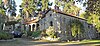
[Date designated]: November 15, 1972
[Locality]: 6211 Arroyo Glen34°6′48″N 118°11′06″W / 34.11333°N 118.18500°W / 34.11333; -118.18500 (106. San Encino Abbey)
[Neighborhood]: Highland Park
[Description]: Modeled on a 17th-century monastery and includes rocks and bits of masonry from old monasteries, castles and European ruins
(Current and former Historic-Cultural Monuments) -
[HCM #]: 107
[Landmark name]: McClure Residence
[Image]:
[Date designated]: November 15, 1972
[Locality]: 432-498 N. Avenue 6634°7′01″N 118°10′35″W / 34.11694°N 118.17639°W / 34.11694; -118.17639 (107. Residence at 432-498 N. Avenue 66)
[Neighborhood]: Garvanza
[Description]: Queen Anne and Eastlake style Victorian house built c. 1890
(Current and former Historic-Cultural Monuments) -
[HCM #]: 108
[Landmark name]: Beaudry Avenue House
[Image]:
[Date designated]: January 3, 1973
[Locality]: 3800 Homer St.34°5′16″N 118°12′30″W / 34.08778°N 118.20833°W / 34.08778; -118.20833 (108. Beaudry Avenue House)
[Neighborhood]: Montecito Heights
[Description]: Italianate, Queen Anne and Eastlake style Victorian house built in 1885; moved to Heritage Square Museum in 1974
(Current and former Historic-Cultural Monuments) -
[HCM #]: 142
[Landmark name]: El Mio
[Image]:
[Date designated]: April 16, 1975
[Locality]: 5905 El Mio Dr.34°6′51″N 118°11′34″W / 34.11417°N 118.19278°W / 34.11417; -118.19278 (142. Smith Estate)
[Neighborhood]: Highland Park
[Description]: Queen Anne and Eastlake house built in 1887 for Judge David Patterson Hatch, who relocated from Santa Barbara to preside over the Lucky Baldwin breach of promise lawsuit. The house is listed on the National Register under the Smith Estate, named after a family that owned it for over 60 years.
(Current and former Historic-Cultural Monuments) -
[HCM #]: 143
[Landmark name]: Residence at 6028 Hayes Avenue
[Image]: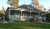
[Date designated]: April 16, 1975
[Locality]: 6028 Hayes Ave.34°6′35″N 118°11′13″W / 34.10972°N 118.18694°W / 34.10972; -118.18694 (143. Residence at 6028 Hayes Avenue)
[Neighborhood]: Highland Park
[Description]:
(Current and former Historic-Cultural Monuments) -
[HCM #]: 144
[Landmark name]: Residence at 2054-2056 Griffin Avenue
[Image]:
[Date designated]: May 21, 1975
[Locality]: 2054-2056 Griffin Ave.34°4′09″N 118°12′41″W / 34.06917°N 118.21139°W / 34.06917; -118.21139 (144. Residence at 2054-2056 Griffin Avenue)
[Neighborhood]: Lincoln Heights
[Description]:
(Current and former Historic-Cultural Monuments) -
[HCM #]: 145
[Landmark name]: Residence at 3537 Griffin Avenue
[Image]:
[Date designated]: May 21, 1975
[Locality]: 3537 Griffin Ave.34°5′09″N 118°12′37″W / 34.08583°N 118.21028°W / 34.08583; -118.21028 (145. Residence at 3537 Griffin Avenue)
[Neighborhood]: Montecito Heights
[Description]:
(Current and former Historic-Cultural Monuments) -
[HCM #]: 153
[Landmark name]: Lincoln Park Carousel
[Image]:
[Date designated]: April 21, 1976
[Locality]: Valley Boulevard & Mission Road
[Neighborhood]: Lincoln Heights
[Description]: Demolished: 08-25-1976 after severe fire damage
(Current and former Historic-Cultural Monuments) -
[HCM #]: 156
[Landmark name]: Fire Station No. 1
[Image]:
[Date designated]: July 7, 1976
[Locality]: 2230 Pasadena Ave.34°4′31″N 118°13′06″W / 34.07528°N 118.21833°W / 34.07528; -118.21833 (156. Fire Station No. 1)
[Neighborhood]: Lincoln Heights
[Description]: The 1940 LAFD station is classified as an example of Streamline Moderne architecture.
(Current and former Historic-Cultural Monuments) -
[HCM #]: 157
[Landmark name]: Residence at 3110 N. Broadway
[Image]:
[Date designated]: July 7, 1976
[Locality]: 3110 N. Broadway34°4′25″N 118°12′31″W / 34.07361°N 118.20861°W / 34.07361; -118.20861 (157. Residence at 3110 N. Broadway)
[Neighborhood]: Lincoln Heights
[Description]:
(Current and former Historic-Cultural Monuments) -
[HCM #]: 164
[Landmark name]: Glendale-Hyperion Bridge
[Image]:
[Date designated]: October 20, 1976
[Locality]: Los Angeles River
[Neighborhood]: Griffith Park
[Description]: The 56-foot-wide (17 m), 1,370-foot-long (420 m) bridge crosses over the Los Angeles River, Golden State Freeway and Riverside Drive, between Ettrick Street and Glenfeliz Boulevard. Completed in 1929, it features a series of reinforced concrete arches.
(Current and former Historic-Cultural Monuments) -
[HCM #]: 245
[Landmark name]: Lincoln Avenue Church Building
[Image]:
[Date designated]: June 4, 1981
[Locality]: 3800 Homer Street
[Neighborhood]: Montecito Heights
[Description]:
(Current and former Historic-Cultural Monuments) -
[HCM #]: 261
[Landmark name]: Lincoln Heights Branch Library
[Image]:
[Date designated]: June 3, 1983
[Locality]: 2530 Workman St.34°04′34″N 118°12′51″W / 34.07611°N 118.21417°W / 34.07611; -118.21417 (261. Lincoln Heights Branch)
[Neighborhood]: Lincoln Heights
[Description]: Second oldest branch library in Los Angeles; built in 1916 with a grant from Andrew Carnegie
(Current and former Historic-Cultural Monuments) -
[HCM #]: 262
[Landmark name]: Residence at 2700 Eagle Street
[Image]:
[Date designated]: June 3, 1983
[Locality]: 2700 Eagle St.34°2′16.7″N 118°12′30.26″W / 34.037972°N 118.2084056°W / 34.037972; -118.2084056 (262. Residence at 2700 Eagle Street)
[Neighborhood]: Boyle Heights
[Description]:
(Current and former Historic-Cultural Monuments) -
[HCM #]: 263
[Landmark name]: Villa Rafael
[Image]:
[Date designated]: June 3, 1983
[Locality]: 2123 Parkside Ave.34°4′11″N 118°12′01″W / 34.06972°N 118.20028°W / 34.06972; -118.20028 (263. Villa Rafael)
[Neighborhood]: Lincoln Heights
[Description]:
(Current and former Historic-Cultural Monuments) -
[HCM #]: 265
[Landmark name]: Bridge at Fourth and Lorena Streets
[Image]:
[Date designated]: June 7, 1983
[Locality]: Fourth and Lorena Streets
[Neighborhood]: Boyle Heights
[Description]:
(Current and former Historic-Cultural Monuments) -
[HCM #]: 269
[Landmark name]: Mount Washington Cable Car Station
[Image]:
[Date designated]: June 28, 1983
[Locality]: 200-202 W. Avenue 4334°5′43″N 118°12′35″W / 34.09528°N 118.20972°W / 34.09528; -118.20972 (269. Mount Washington Cable Car Station)
[Neighborhood]: Mt. Washington
[Description]:
(Current and former Historic-Cultural Monuments) -
[HCM #]: 274
[Landmark name]: Highland Park Police Station
[Image]:
[Date designated]: January 4, 1984
[Locality]: 6045 York Blvd.34°7′8″N 118°11′12″W / 34.11889°N 118.18667°W / 34.11889; -118.18667 (274. Highland Park Police Station)
[Neighborhood]: Highland Park
[Description]: Former police station built in 1926; now used as the Los Angeles Police Museum
(Current and former Historic-Cultural Monuments) -
[HCM #]: 282
[Landmark name]: Highland Park Masonic Temple
[Image]:
[Date designated]: August 29, 1984
[Locality]: 104 N. Avenue 5634°6′32″N 118°11′37″W / 34.10889°N 118.19361°W / 34.10889; -118.19361 (282. Highland Park Masonic Temple)
[Neighborhood]: Highland Park
[Description]: Well-preserved Masonic Temple built in 1923; now used as a banquet facility
(Current and former Historic-Cultural Monuments) -
[HCM #]: 283
[Landmark name]: Southwest Museum
[Image]:
[Date designated]: August 29, 1984
[Locality]: 234 Museum Dr.34°6′3″N 118°12′21″W / 34.10083°N 118.20583°W / 34.10083; -118.20583 (283. Southwest Museum)
[Neighborhood]: Mt. Washington
[Description]: Museum and archive for American Indian and Western art and artifacts; opened 1914
(Current and former Historic-Cultural Monuments) -
[HCM #]: 284
[Landmark name]: Highland Park Ebell Club Building
[Image]: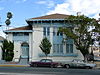
[Date designated]: August 29, 1984
[Locality]: 125-135 S. Avenue 5734°6′31″N 118°11′32″W / 34.10861°N 118.19222°W / 34.10861; -118.19222 (284. Highland Park Ebell Club Building)
[Neighborhood]: Highland Park
[Description]: Ebell women's club, Highland Park chapter building, built 1912.
(Current and former Historic-Cultural Monuments) -
[HCM #]: 287
[Landmark name]: Yoakum House
[Image]:
[Date designated]: January 18, 1985
[Locality]: 140-154 S. Avenue 5934°6′33″N 118°11′26″W / 34.10917°N 118.19056°W / 34.10917; -118.19056 (287. Yoakum House)
[Neighborhood]: Highland Park
[Description]: Father Finis Ewing Yoakum (Pisgah Home halfway house founder) lived in this the 2-story house; built in 1915 Tudor revival style;
(Current and former Historic-Cultural Monuments) -
[HCM #]: 292
[Landmark name]: Old Eagle Rock Branch Library
[Image]: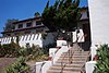
[Date designated]: June 18, 1985
[Locality]: 2225 Colorado Blvd.34°8′22″N 118°12′53″W / 34.13944°N 118.21472°W / 34.13944; -118.21472 (292. Old Eagle Rock Branch Library)
[Neighborhood]: Eagle Rock
[Description]: The former Carnegie library was built in 1915 in a Mission Revival and Spanish Colonial Revival style
(Current and former Historic-Cultural Monuments) -
[HCM #]: 304
[Landmark name]: Malabar Branch Library
[Image]:
[Date designated]: May 19, 1987
[Locality]: 2801 Wabash Ave.34°3′2″N 118°11′47″W / 34.05056°N 118.19639°W / 34.05056; -118.19639 (304. Malabar Branch)
[Neighborhood]: Boyle Heights
[Description]: Branch library; built in 1926; ornamental frieze above entrance
(Current and former Historic-Cultural Monuments) -
[HCM #]: 322
[Landmark name]: Fletcher Drive Bridge
[Image]:
[Date designated]: July 21, 1987
[Locality]: Fletcher Drive at Los Angeles River
[Neighborhood]: Atwater Village
[Description]:
(Current and former Historic-Cultural Monuments) -
[HCM #]: 338
[Landmark name]: Drake House
[Image]:
[Date designated]: January 26, 1988
[Locality]: 210-220 S. Avenue 6034°6′35″N 118°11′17″W / 34.10972°N 118.18806°W / 34.10972; -118.18806 (338. Drake House)
[Neighborhood]: Highland Park
[Description]:
(Current and former Historic-Cultural Monuments) -
[HCM #]: 339
[Landmark name]: Santa Fe Arroyo Seco Railroad Bridge
[Image]:
[Date designated]: January 26, 1988
[Locality]: 162 S. Avenue 6134°6′35″N 118°11′12″W / 34.10972°N 118.18667°W / 34.10972; -118.18667 (339. Santa Fe Arroyo Seco Railroad Bridge)
[Neighborhood]: Highland Park
[Description]:
(Current and former Historic-Cultural Monuments) -
[HCM #]: 359
[Landmark name]: Breed Street Shul (Congregation Talmud Torah)
[Image]:
[Date designated]: November 4, 2001
[Locality]: 247 N. Breed St.34°2′48″N 118°12′31″W / 34.04667°N 118.20861°W / 34.04667; -118.20861 (359. Congregation Talmud Torah of Los Angeles)
[Neighborhood]: Boyle Heights
[Description]: Largest Orthodox synagogue in the western United States from 1915 to 1951
(Current and former Historic-Cultural Monuments) -
[HCM #]: 366
[Landmark name]: Latter House and Arroyo Stone Wall
[Image]:
[Date designated]: June 21, 1988
[Locality]: 137-151 S. Avenue 5734°6′30″N 118°11′32″W / 34.10833°N 118.19222°W / 34.10833; -118.19222 (366. Latter House and Arroyo Stone Wall)
[Neighborhood]: Highland Park
[Description]:
(Current and former Historic-Cultural Monuments) -
[HCM #]: 369
[Landmark name]: Johnson House & Arroyo Stone Wall
[Image]:
[Date designated]: July 15, 1988
[Locality]: 4985 N. Figueroa St.34°6′16″N 118°12′09″W / 34.10444°N 118.20250°W / 34.10444; -118.20250 (369. Johnson House & Arroyo Stone Wall)
[Neighborhood]: Highland Park
[Description]:
(Current and former Historic-Cultural Monuments) -
[HCM #]: 370
[Landmark name]: Herivel House & Arroyo Stone Wall
[Image]:
[Date designated]: July 15, 1988
[Locality]: 4979-4985 N. Figueroa St.34°6′15″N 118°12′09″W / 34.10417°N 118.20250°W / 34.10417; -118.20250 (370. Herivel House & Arroyo Stone Wall)
[Neighborhood]: Highland Park
[Description]:
(Current and former Historic-Cultural Monuments) -
[HCM #]: 371
[Landmark name]: Tustin House & Arroyo Stone Wall
[Image]:
[Date designated]: July 15, 1988
[Locality]: 4967-4973 N. Figueroa St.34°6′15″N 118°12′10″W / 34.10417°N 118.20278°W / 34.10417; -118.20278 (371. Tustin House & Arroyo Stone Wall)
[Neighborhood]: Highland Park
[Description]:
(Current and former Historic-Cultural Monuments) -
[HCM #]: 372
[Landmark name]: Mary P. Field House & Arroyo Stone Wall
[Image]:
[Date designated]: July 15, 1988
[Locality]: 4967-4971 N. Sycamore Terrace34°6′16″N 118°12′10″W / 34.10444°N 118.20278°W / 34.10444; -118.20278 (372. Mary P. Field House & Arroyo Stone Wall)
[Neighborhood]: Highland Park
[Description]:
(Current and former Historic-Cultural Monuments) -
[HCM #]: 373
[Landmark name]: Arroyo Stone House & Arroyo Stone Wall
[Image]:
[Date designated]: July 15, 1988
[Locality]: 4939 N. Figueroa St.34°6′12″N 118°12′10″W / 34.10333°N 118.20278°W / 34.10333; -118.20278 (373. Arroyo Stone House & Arroyo Stone Wall)
[Neighborhood]: Highland Park
[Description]:
(Current and former Historic-Cultural Monuments) -
[HCM #]: 374
[Landmark name]: G.W.E. Griffith House
[Image]: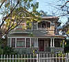
[Date designated]: July 15, 1988
[Locality]: 5915-5919 Echo St.34°6′35″N 118°11′22″W / 34.10972°N 118.18944°W / 34.10972; -118.18944 (374. G.W.E. Griffith House)
[Neighborhood]: Highland Park
[Description]:
(Current and former Historic-Cultural Monuments) -
[HCM #]: 375
[Landmark name]: Putnam House
[Image]:
[Date designated]: July 15, 1988
[Locality]: 5944-5948 Hayes Ave.34°6′32″N 118°11′19″W / 34.10889°N 118.18861°W / 34.10889; -118.18861 (375. Putnam House)
[Neighborhood]: Highland Park
[Description]:
(Current and former Historic-Cultural Monuments) -
[HCM #]: 376
[Landmark name]: William U. Smith House & Arroyo Stone Wall
[Image]:
[Date designated]: July 15, 1988
[Locality]: 140 S. Avenue 57
[Neighborhood]: Highland Park
[Description]:
(Current and former Historic-Cultural Monuments) -
[HCM #]: 377
[Landmark name]: Ollie Tract
[Image]:
[Date designated]: July 15, 1988
[Locality]: 179-199 S. Avenue 57; 5701-5731 Benner Street
[Neighborhood]: Highland Park
[Description]:
(Current and former Historic-Cultural Monuments) -
[HCM #]: 378
[Landmark name]: Wheeler - Smith House
[Image]:
[Date designated]: July 15, 1988
[Locality]: 5676-5688 Ash Street
[Neighborhood]:
[Description]:
(Current and former Historic-Cultural Monuments) -
[HCM #]: 379
[Landmark name]: Morrell House
[Image]:
[Date designated]: July 15, 1988
[Locality]: 215 N. Avenue 53
[Neighborhood]: Highland Park
[Description]:
(Current and former Historic-Cultural Monuments) -
[HCM #]: 380
[Landmark name]: Reeves House
[Image]:
[Date designated]: July 15, 1988
[Locality]: 219 N. Avenue 53
[Neighborhood]: Highland Park
[Description]: Destroyed by trash fire: 10-10-2017
(Current and former Historic-Cultural Monuments) -
[HCM #]: 383
[Landmark name]: Residence at 1203-1207 Kipling Avenue
[Image]: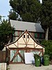
[Date designated]: August 5, 1988
[Locality]: 1203-1207 Kipling Avenue
[Neighborhood]: Eagle Rock
[Description]:
(Current and former Historic-Cultural Monuments) -
[HCM #]: 384
[Landmark name]: Department of Water and Power Building
[Image]:
[Date designated]: August 5, 1988
[Locality]: 2417 Daly St.34°4′27″N 118°12′56″W / 34.07417°N 118.21556°W / 34.07417; -118.21556 (384. Department of Water and Power Building)
[Neighborhood]: Lincoln Heights
[Description]:
(Current and former Historic-Cultural Monuments) -
[HCM #]: 388
[Landmark name]: Edison Electric Company (Los Angeles No. 3 Steam Power Plant)
[Image]:
[Date designated]: October 21, 1988
[Locality]: 650 S. Avenue 2134°3′49″N 118°13′01″W / 34.06361°N 118.21694°W / 34.06361; -118.21694 (388. Edison Electric Company)
[Neighborhood]: Lincoln Heights
[Description]:
(Current and former Historic-Cultural Monuments) -
[HCM #]: 389
[Landmark name]: C. M. Church House
[Image]:
[Date designated]: October 4, 1988
[Locality]: 5907 Echo St.34°6′35″N 118°11′24″W / 34.10972°N 118.19000°W / 34.10972; -118.19000 (389. C. M. Church House)
[Neighborhood]: Highland Park
[Description]:
(Current and former Historic-Cultural Monuments) -
[HCM #]: 392
[Landmark name]: Treehaven Guest House and Grounds
[Image]:
[Date designated]: November 4, 1988
[Locality]: 4211 Glenalbyn Dr.34°5′44″N 118°12′40″W / 34.09556°N 118.21111°W / 34.09556; -118.21111 (392. Treehaven Guest House and Grounds)
[Neighborhood]: Mt. Washington
[Description]:
(Current and former Historic-Cultural Monuments) -
[HCM #]: 393
[Landmark name]: Wiles House and Grounds
[Image]:
[Date designated]: November 4, 1988
[Locality]: 4224 Glenalbyn Dr.34°5′43″N 118°12′38″W / 34.09528°N 118.21056°W / 34.09528; -118.21056 (393. Wiles House and Grounds)
[Neighborhood]: Mt. Washington
[Description]:
(Current and former Historic-Cultural Monuments) -
[HCM #]: 394
[Landmark name]: Ernest and Florence Bent Halstead House and Grounds
[Image]:
[Date designated]: November 4, 1988
[Locality]: 4200 Glenalbyn Dr.34°5′42″N 118°12′40″W / 34.09500°N 118.21111°W / 34.09500; -118.21111 (394. Ernest and Florence Bent Halstead House and Grounds)
[Neighborhood]: Mt. Washington
[Description]: An American Craftsman style home built in 1908
(Current and former Historic-Cultural Monuments) -
[HCM #]: 395
[Landmark name]: H. Stanley Bent House
[Image]:
[Date designated]: November 4, 1988
[Locality]: 4201 Glenalbyn Dr.34°5′44″N 118°12′42″W / 34.09556°N 118.21167°W / 34.09556; -118.21167 (395. H. Stanley Bent House)
[Neighborhood]: Mt. Washington
[Description]: includes carriage house and front fountain
(Current and former Historic-Cultural Monuments) -
[HCM #]: 396
[Landmark name]: Federal Bank Building
[Image]:
[Date designated]: November 23, 1988
[Locality]: 2201 N. Broadway
[Neighborhood]: Lincoln Heights
[Description]:
(Current and former Historic-Cultural Monuments) -
[HCM #]: 400
[Landmark name]: Sunrise Court
[Image]:
[Date designated]: November 23, 1988
[Locality]: 5721-5729 Monte Vista Street
[Neighborhood]: Highland Park
[Description]:
(Current and former Historic-Cultural Monuments) -
[HCM #]: 402
[Landmark name]: Frederic M. Ashley House
[Image]:
[Date designated]: December 9, 1988
[Locality]: 740-742 N. Avenue 6634°7′10″N 118°10′28″W / 34.11944°N 118.17444°W / 34.11944; -118.17444 (402. Frederic M. Ashley House)
[Neighborhood]: Garvanza
[Description]:
(Current and former Historic-Cultural Monuments) -
[HCM #]: 404
[Landmark name]: Los Angeles Railway Huron Substation
[Image]:
[Date designated]: December 20, 1988
[Locality]: 2640 N. Huron St.34°5′07″N 118°13′19″W / 34.08528°N 118.22194°W / 34.08528; -118.22194 (404. Los Angeles Railway Huron Substation)
[Neighborhood]: Cypress Park
[Description]:
(Current and former Historic-Cultural Monuments) -
[HCM #]: 411
[Landmark name]: Robert Edmund Williams House (Hathaway Home for Children)
[Image]:
[Date designated]: January 18, 1989
[Locality]: 840 N. Avenue 66
[Neighborhood]: Garvanza
[Description]:
(Current and former Historic-Cultural Monuments) -
[HCM #]: 412
[Landmark name]: Garvanza Pumping Station and site of Highland Reservoir
[Image]:
[Date designated]: January 20, 1989
[Locality]: 420 N. Avenue 62
[Neighborhood]: Garvanza
[Description]:
(Current and former Historic-Cultural Monuments) -
[HCM #]: 413
[Landmark name]: Octagon House
[Image]: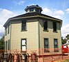
[Date designated]: January 20, 1989
[Locality]: 3800 Homer St.34°5′17″N 118°12′30″W / 34.08806°N 118.20833°W / 34.08806; -118.20833 (413. Octagon House)
[Neighborhood]: Montecito Heights
[Description]: Eight-sided house built by Gilbert Longfellow in 1893; Now located at Heritage Square Museum
(Current and former Historic-Cultural Monuments) -
[HCM #]: 416
[Landmark name]: Ziegler Estate
[Image]:
[Date designated]: February 21, 1989
[Locality]: 4601 N. Figueroa Blvd.34°5′55″N 118°12′16″W / 34.09861°N 118.20444°W / 34.09861; -118.20444 (416. Ziegler Estate)
[Neighborhood]: Highland Park
[Description]:
(Current and former Historic-Cultural Monuments) -
[HCM #]: 418
[Landmark name]: George W. Wilson Estate
[Image]:
[Date designated]: February 17, 1989
[Locality]: 616 N. Avenue 66
[Neighborhood]: Highland Park
[Description]: Destroyed by fire: 12-14-1989
(Current and former Historic-Cultural Monuments) -
[HCM #]: 437
[Landmark name]: A. H. Judson Estate
[Image]:
[Date designated]: May 19, 1989
[Locality]: 4909-4915 N. Sycamore Terrace; 4911 Pasadena Avenue Terrace
[Neighborhood]: Mount Washington
[Description]: Demolished: 01-01-1992
(Current and former Historic-Cultural Monuments) -
[HCM #]: 442
[Landmark name]: Albion Cottages and Milagro Market
[Image]:
[Date designated]: June 20, 1989
[Locality]: 1801-1813 Albion Street
[Neighborhood]: Lincoln Heights
[Description]:
(Current and former Historic-Cultural Monuments) -
[HCM #]: 443
[Landmark name]: Bowman Residence
[Image]:
[Date designated]: June 20, 1989
[Locality]: 2425 Griffin Avenue
[Neighborhood]: Lincoln Heights
[Description]:
(Current and former Historic-Cultural Monuments) -
[HCM #]: 461
[Landmark name]: Meyers House
[Image]:
[Date designated]: November 3, 1989
[Locality]: 4340 Eagle Rock Boulevard
[Neighborhood]: Eagle Rock
[Description]: Destroyed by fire: 01-01-1992
(Current and former Historic-Cultural Monuments) -
[HCM #]: 464
[Landmark name]: Fargo House
[Image]:
[Date designated]: November 3, 1989
[Locality]: 206 Thorne Street
[Neighborhood]: Garvanza
[Description]:
(Current and former Historic-Cultural Monuments) -
[HCM #]: 468
[Landmark name]: Sacred Heart Church
[Image]:
[Date designated]: December 5, 1989
[Locality]: 2210 Sichel St.34°4′14″N 118°12′45″W / 34.07056°N 118.21250°W / 34.07056; -118.21250 (468. Sacred Heart Church)
[Neighborhood]: Lincoln Heights
[Description]:
(Current and former Historic-Cultural Monuments) -
[HCM #]: 469
[Landmark name]: Ivar I. Phillips Dwelling
[Image]:
[Date designated]: December 20, 1989
[Locality]: 4200 N. Figueroa Street
[Neighborhood]: Highland Park
[Description]:
(Current and former Historic-Cultural Monuments) -
[HCM #]: 470
[Landmark name]: Ivar I. Phillips Residence
[Image]:
[Date designated]: December 20, 1989
[Locality]: 4204 N. Figueroa Street
[Neighborhood]: Highland Park
[Description]:
(Current and former Historic-Cultural Monuments) -
[HCM #]: 471
[Landmark name]: Argus Court
[Image]:
[Date designated]: December 20, 1989
[Locality]: 1760-1768 Colorado Boulevard
[Neighborhood]: Eagle Rock
[Description]:
(Current and former Historic-Cultural Monuments) -
[HCM #]: 481
[Landmark name]: Mauer House
[Image]:
[Date designated]: March 23, 1990
[Locality]: 932 Rome Drive
[Neighborhood]: Mt. Washington
[Description]:
(Current and former Historic-Cultural Monuments) -
[HCM #]: 482
[Landmark name]: Arthur S. Bent House
[Image]:
[Date designated]: May 1, 1987
[Locality]: 161-169 S. Avenue 49
[Neighborhood]: Highland Park
[Description]:
(Current and former Historic-Cultural Monuments) -
[HCM #]: 483
[Landmark name]: J. B. Merrill House
[Image]:
[Date designated]: March 23, 1990
[Locality]: 815 Elyria Drive
[Neighborhood]: Mt. Washington
[Description]:
(Current and former Historic-Cultural Monuments) -
[HCM #]: 486
[Landmark name]: Nineteenth Century Los Angeles Chinese Cemetery Shrine
[Image]:
[Date designated]: August 31, 1990
[Locality]: 204 N. Evergreen Street
[Neighborhood]: Boyle Heights
[Description]: Oldest surviving structure of Chinese settlement in Los Angeles; use of traditional ceremonies brought from China
(Current and former Historic-Cultural Monuments) -
[HCM #]: 492
[Landmark name]: Arroyo Seco Bank Building
[Image]:
[Date designated]: July 13, 1990
[Locality]: 6169-6199 York Blvd.; 6301-6311 N. Figueroa St.
[Neighborhood]: Highland Park
[Description]:
(Current and former Historic-Cultural Monuments) -
[HCM #]: 493
[Landmark name]: Casa de Adobe
[Image]:
[Date designated]: July 13, 1990
[Locality]: 4603-4613 Figueroa St & 4610-4618 Woodside
[Neighborhood]: Highland Park
[Description]:
(Current and former Historic-Cultural Monuments) -
[HCM #]: 494
[Landmark name]: Kelman Residence and Carriage Barn
[Image]:
[Date designated]: July 13, 1990
[Locality]: 5029 Echo Street
[Neighborhood]: Highland Park
[Description]:
(Current and former Historic-Cultural Monuments) -
[HCM #]: 503
[Landmark name]: Wachtel Studio - Home & Eucalyptus Grove
[Image]:
[Date designated]: October 9, 1990
[Locality]: 315 W. Avenue 43 & 4306 Glenmuir Avenue
[Neighborhood]: Mt. Washington
[Description]:
(Current and former Historic-Cultural Monuments) -
[HCM #]: 528
[Landmark name]: Dr. Franklin S. Whaley Residence
[Image]:
[Date designated]: April 23, 1991
[Locality]: 6434 Crescent Street
[Neighborhood]: Garvanza
[Description]:
(Current and former Historic-Cultural Monuments) -
[HCM #]: 529
[Landmark name]: Montecito View House
[Image]:
[Date designated]: April 23, 1991
[Locality]: 4115 Berenice Place
[Neighborhood]: Montecito Heights
[Description]:
(Current and former Historic-Cultural Monuments) -
[HCM #]: 533
[Landmark name]: Residence at 2660 Sichel Street
[Image]:
[Date designated]: June 11, 1991
[Locality]: 2660 Sichel Street
[Neighborhood]: Lincoln Heights
[Description]:
(Current and former Historic-Cultural Monuments) -
[HCM #]: 536
[Landmark name]: Eagle Rock Playground Clubhouse
[Image]:
[Date designated]: July 2, 1991
[Locality]: 1100 Eagle Vista Drive
[Neighborhood]: Eagle RockDesigned by Richard Neutra in 1949.
[Description]:
(Current and former Historic-Cultural Monuments) -
[HCM #]: 537
[Landmark name]: Eagle Rock Women's Twentieth Century Clubhouse
[Image]:
[Date designated]: July 2, 1991
[Locality]: 1841-1855 Colorado Bl/5101-5105 Hermosa Ave
[Neighborhood]: Eagle Rock
[Description]:
(Current and former Historic-Cultural Monuments) -
[HCM #]: 539
[Landmark name]: J.E. Maxwell Residence
[Image]:
[Date designated]: July 19, 1991
[Locality]: 211 S. Avenue 52
[Neighborhood]: Highland Park
[Description]:
(Current and former Historic-Cultural Monuments) -
[HCM #]: 540
[Landmark name]: Piper House (Los Angeles)
[Image]:
[Date designated]: July 19, 1991
[Locality]: 326 N. Avenue 53
[Neighborhood]: Highland Park
[Description]: Destroyed by fire: 08-20-1995
(Current and former Historic-Cultural Monuments) -
[HCM #]: 541
[Landmark name]: Reverend Williel Thomson Residence
[Image]:
[Date designated]: July 19, 1991
[Locality]: 215 S. Avenue 52
[Neighborhood]: Highland Park
[Description]:
(Current and former Historic-Cultural Monuments) -
[HCM #]: 542
[Landmark name]: Swanson House
[Image]:
[Date designated]: July 2, 1991
[Locality]: 2373 Addison Way
[Neighborhood]: Eagle Rock
[Description]:
(Current and former Historic-Cultural Monuments) -
[HCM #]: 549
[Landmark name]: Highland Theater Building
[Image]:
[Date designated]: October 2, 1991
[Locality]: 103 E. Avenue 56 & 5600-5608 N Figueroa
[Neighborhood]: Highland Park
[Description]:
(Current and former Historic-Cultural Monuments) -
[HCM #]: 550
[Landmark name]: A.J. Madison House
[Image]:
[Date designated]: October 2, 1991
[Locality]: 148-150 S. Avenue 56
[Neighborhood]: Highland Park
[Description]:
(Current and former Historic-Cultural Monuments) -
[HCM #]: 554
[Landmark name]: La Paloma (house)
[Image]:
[Date designated]: March 18, 1992
[Locality]: 357-369 N. Avenue 53 & 5300-5320 Granada St
[Neighborhood]: Highland Park
[Description]:
(Current and former Historic-Cultural Monuments) -
[HCM #]: 556
[Landmark name]: Charlie and Nettie Williams Home
[Image]:
[Date designated]: April 21, 1992
[Locality]: 212-214 N. Avenue 57
[Neighborhood]: Highland Park
[Description]:
(Current and former Historic-Cultural Monuments) -
[HCM #]: 558
[Landmark name]: Department of Water and Power Distributing Station No. 2
[Image]:
[Date designated]: April 21, 1992
[Locality]: 211-235 N. Avenue 61; 6100-6114 Mount Angelus Drive; 6112 Monte Vista Street
[Neighborhood]: Highland Park
[Description]:
(Current and former Historic-Cultural Monuments) -
[HCM #]: 562
[Landmark name]: Eagle Rock Women's Christian Temperence Union Home
[Image]:
[Date designated]: May 26, 1992
[Locality]: 2222-2244 Laverna Ave & 2225-2245 Norwalk Ave.; 2225-2245 Norwalk Ave & 2222-2244 Laverna Av
[Neighborhood]: Eagle Rock
[Description]:
(Current and former Historic-Cultural Monuments) -
[HCM #]: 564
[Landmark name]: E.A. Spencer Estate
[Image]:
[Date designated]: August 25, 1992
[Locality]: 5660 Ash Street
[Neighborhood]: Highland Park
[Description]: An American Foursquare style home designed by Charles C. Dodge in 1898
(Current and former Historic-Cultural Monuments) -
[HCM #]: 565
[Landmark name]: Charles H. Greenshaw Residence
[Image]:
[Date designated]: August 25, 1992
[Locality]: 1102-1114 Lantana Dr & 6371-7381 Rosswd Ter
[Neighborhood]: Garvanza
[Description]:
(Current and former Historic-Cultural Monuments) -
[HCM #]: 569
[Landmark name]: Van De Kamp's Holland Dutch Bakery
[Image]:
[Date designated]: May 12, 1992
[Locality]: 2900-2930 Fletcher Dr & 3016-3020 San Fernando Rd.
[Neighborhood]: Glassell Park
[Description]: Now house the satellite campus of Los Angeles City College.
(Current and former Historic-Cultural Monuments) -
[HCM #]: 575
[Landmark name]: Security Trust and Savings Bank (Highland Park Branch)
[Image]:
[Date designated]: February 9, 1993
[Locality]: 101-107 N. Avenue 56/5601-5603 N Figueroa St
[Neighborhood]: Highland Park
[Description]:
(Current and former Historic-Cultural Monuments) -
[HCM #]: 581
[Landmark name]: York Boulevard State Bank - Bank of America and Storefronts
[Image]:
[Date designated]: August 10, 1993
[Locality]: 1301-1313 N. Avenue 51 & 5057-5061 York Blvd
[Neighborhood]: Highland Park
[Description]:
(Current and former Historic-Cultural Monuments) -
[HCM #]: 582
[Landmark name]: W.F. Poor Resldence
[Image]:
[Date designated]: August 10, 1993
[Locality]: 120 N. Avenue 54
[Neighborhood]: Highland Park
[Description]:
(Current and former Historic-Cultural Monuments) -
[HCM #]: 585
[Landmark name]: Occidental College Hall of Letters Building (Savoy Apartments)
[Image]:
[Date designated]: October 15, 1993
[Locality]: 121 N. Avenue 50
[Neighborhood]: Highland Park
[Description]: Built in 1904 and designed by Oliver Perry Dennis and Lyman Farwell, this originally three storey, brick building is the only remaining principal structure from the Highland Park campus of Occidental College that was in use from 1897 until 1914.
(Current and former Historic-Cultural Monuments) -
[HCM #]: 587
[Landmark name]: Lincoln Heights Jail (Los Angeles City Jail)
[Image]:
[Date designated]: November 30, 1993
[Locality]: 401-449 N. Avenue 19
[Neighborhood]: Lincoln Heights
[Description]:
(Current and former Historic-Cultural Monuments) -
[HCM #]: 590
[Landmark name]: Brooklyn Avenue Neighborhood Corridor
[Image]:
[Date designated]: March 8, 1994
[Locality]: Cesar E. Chavez Avenue
[Neighborhood]: Boyle Heights
[Description]:
(Current and former Historic-Cultural Monuments) -
[HCM #]: 611
[Landmark name]: Minister Residence
[Image]:
[Date designated]: November 8, 1994
[Locality]: 4151-4167 Sea View Drive & 4163 Sea View Ln
[Neighborhood]: Mt. Washington
[Description]:
(Current and former Historic-Cultural Monuments) -
[HCM #]: 612
[Landmark name]: Birtcher-Share Residence
[Image]:
[Date designated]: November 8, 1994
[Locality]: 4200-4216 Sea View Drive & 4234 Sea View Ln
[Neighborhood]: Mt. Washington
[Description]:
(Current and former Historic-Cultural Monuments) -
[HCM #]: 613
[Landmark name]: Scholfield House
[Image]:
[Date designated]: November 8, 1994
[Locality]: 4222-4230 Sea View Drive & 4252 Sea View Ln
[Neighborhood]: Mt. Washington
[Description]:
(Current and former Historic-Cultural Monuments) -
[HCM #]: 614
[Landmark name]: Wolford House
[Image]:
[Date designated]: November 8, 1994
[Locality]: 4242 Sea View Drive & 4260 Sea View Lane
[Neighborhood]: Mt. Washington
[Description]: Architect James DeLong designed this Usonian style house in 1951.
(Current and former Historic-Cultural Monuments) -
[HCM #]: 691
[Landmark name]: Carl C. Warden Residence
[Image]:
[Date designated]: March 23, 2001
[Locality]: 878 N. Rome Drive
[Neighborhood]: Mt. Washington
[Description]: 1909, Meyer & Holler
(Current and former Historic-Cultural Monuments) -
[HCM #]: 692
[Landmark name]: Dahlia Motors Building
[Image]:
[Date designated]: April 24, 2001
[Locality]: 1627 W. Colorado Boulevard
[Neighborhood]: Eagle Rock
[Description]:
(Current and former Historic-Cultural Monuments) -
[HCM #]: 713
[Landmark name]: Santa Fe Coast Lines Hospital
[Image]:
[Date designated]: January 3, 2006
[Locality]: 610-30 S. Louis St.34°2′16″N 118°12′31″W / 34.03778°N 118.20861°W / 34.03778; -118.20861 (713. Santa Fe Coast Lines Hospital)
[Neighborhood]: Boyle Heights
[Description]: Hospital built for employees of Santa Fe Railroad; later known as Linda Vista Hospital
(Current and former Historic-Cultural Monuments) -
[HCM #]: 717
[Landmark name]: Pilot House
[Image]:
[Date designated]: July 30, 2002
[Locality]: 735 Rome Drive
[Neighborhood]: Mt. Washington
[Description]:
(Current and former Historic-Cultural Monuments) -
[HCM #]: 734
[Landmark name]: Bell Commercial Block
[Image]:
[Date designated]: October 29, 2002
[Locality]: 1948-1958 West Colorado Blvd
[Neighborhood]: Eagle Rock
[Description]:
(Current and former Historic-Cultural Monuments) -
[HCM #]: 735
[Landmark name]: Jeffries House
[Image]:
[Date designated]: October 29, 2002
[Locality]: 571 Cypress Avenue
[Neighborhood]: Cypress Park
[Description]:
(Current and former Historic-Cultural Monuments) -
[HCM #]: 736
[Landmark name]: Monterey Trailer Park
[Image]:
[Date designated]: November 5, 2002
[Locality]: 6411 Monterey Rd
[Neighborhood]: Hermon
[Description]:
(Current and former Historic-Cultural Monuments) -
[HCM #]: 738
[Landmark name]: Alfred W. and Grace D. Hare Residence
[Image]:
[Date designated]: November 22, 2002
[Locality]: 2430 W Ridgeview Ave
[Neighborhood]: Eagle Rock
[Description]:
(Current and former Historic-Cultural Monuments) -
[HCM #]: 752
[Landmark name]: Hanson Puthuff House
[Image]:
[Date designated]: April 29, 2003
[Locality]: 5261 College View Ave
[Neighborhood]: Eagle Rock
[Description]:
(Current and former Historic-Cultural Monuments) -
[HCM #]: 753
[Landmark name]: H.W. Ayres House
[Image]:
[Date designated]: April 29, 2003
[Locality]: 3923 San Rafael Ave
[Neighborhood]: Mt. Washington
[Description]:
(Current and former Historic-Cultural Monuments) -
[HCM #]: 758
[Landmark name]: Keran Residence
[Image]:
[Date designated]: July 29, 2003
[Locality]: 2501 West Hill Dr
[Neighborhood]: Eagle Rock
[Description]:
(Current and former Historic-Cultural Monuments) -
[HCM #]: 760
[Landmark name]: Case Residence
[Image]:
[Date designated]: July 29, 2003
[Locality]: 2400 West Hill Dr
[Neighborhood]: Eagle Rock
[Description]:
(Current and former Historic-Cultural Monuments) -
[HCM #]: 771
[Landmark name]: J.L. Hodge Residence
[Image]:
[Date designated]: December 16, 2003
[Locality]: 5329 N Mt Royal Dr
[Neighborhood]: Eagle Rock
[Description]:
(Current and former Historic-Cultural Monuments) -
[HCM #]: 778
[Landmark name]: Murdock Residence
[Image]:
[Date designated]: May 18, 2004
[Locality]: 4219 N Figueroa St
[Neighborhood]: Highland Park
[Description]:
(Current and former Historic-Cultural Monuments) -
[HCM #]: 781
[Landmark name]: Mills Cottage
[Image]:
[Date designated]: June 15, 2004
[Locality]: 4746 Toland Way
[Neighborhood]: Highland Park
[Description]:
(Current and former Historic-Cultural Monuments) -
[HCM #]: 788
[Landmark name]: Sears, Roebuck & Company Mail Order Building
[Image]:
[Date designated]: April 21, 2006
[Locality]: 2650 E. Olympic Blvd.34°1′24″N 118°13′15″W / 34.02333°N 118.22083°W / 34.02333; -118.22083 (788. Sears, Roebuck & Company Mail Order Building)
[Neighborhood]: Boyle Heights
[Description]: 1,800,000-square-foot (170,000 m2) Sears mail order distribution center built in 1927; an iconic landmark of the Eastside
(Current and former Historic-Cultural Monuments) -
[HCM #]: 802
[Landmark name]: Hodel Residence and Tea House
[Image]:
[Date designated]: June 1, 2005
[Locality]: 6508, 6512, 6516 N. Monterey Rd; 6511, 6515, 6519 N. Short Way
[Neighborhood]: Hermon
[Description]:
(Current and former Historic-Cultural Monuments) -
[HCM #]: 807
[Landmark name]: Church of the Epiphany
[Image]:
[Date designated]: June 15, 2005
[Locality]: 2808 N Altura St
[Neighborhood]: Lincoln Heights
[Description]: Oldest operating Episcopal church in Los Angeles; Cesar Chavez gave speeches in the church hall and La Raza was printed in the church basement.
(Current and former Historic-Cultural Monuments) -
[HCM #]: 845
[Landmark name]: Mount Washington Hotel-Self Realization Fellowship International Headquarters
[Image]:
[Date designated]: August 16, 2006
[Locality]: 3880 & 3846 San Rafael Ave; 701 & 721 Mt. Washington Dr
[Neighborhood]: Mt. Washington
[Description]:
(Current and former Historic-Cultural Monuments) -
[HCM #]: 849
[Landmark name]: Nickel Leong Mansion
[Image]:
[Date designated]: August 16, 2006
[Locality]: 3509 E Thorpe Ave; 901 & 903 N Isabel St
[Neighborhood]: Cypress Park
[Description]:
(Current and former Historic-Cultural Monuments) -
[HCM #]: 877
[Landmark name]: Wilkins House
[Image]:
[Date designated]: July 3, 2007
[Locality]: 915-917 North Avenue 57
[Neighborhood]: Highland Park
[Description]: Built for John Wilkins in 1911; the house is emblematic of Craftsman style architecture.
(Current and former Historic-Cultural Monuments) -
[HCM #]: 889
[Landmark name]: McNary House
[Image]:
[Date designated]: October 12, 2007
[Locality]: 4777 Eagle Rock Blvd
[Neighborhood]: Eagle Rock
[Description]:
(Current and former Historic-Cultural Monuments) -
[HCM #]: 890
[Landmark name]: Waite Residence
[Image]:
[Date designated]: October 12, 2007
[Locality]: 2431 Hill Drive
[Neighborhood]: Eagle Rock
[Description]:
(Current and former Historic-Cultural Monuments) -
[HCM #]: 891
[Landmark name]: Boyle Hotel - Cummings Block
[Image]:
[Date designated]: October 24, 2007
[Locality]: 101-105 North Boyle Avenue; 1781-1785 East 1st Street
[Neighborhood]: Boyle Heights
[Description]:
(Current and former Historic-Cultural Monuments) -
[HCM #]: 894
[Landmark name]: Monroe Cottage
[Image]:
[Date designated]: October 30, 2007
[Locality]: 6310 Crescent St
[Neighborhood]: Garvanza
[Description]:
(Current and former Historic-Cultural Monuments) -
[HCM #]: 903
[Landmark name]: Washington Boulevard Bridge, No. 53C1375
[Image]:
[Date designated]: January 30, 2008
[Locality]: E. Washington Boulevard between Soto St. and E. 23rd St.
[Neighborhood]: Boyle Heights
[Description]:
(Current and former Historic-Cultural Monuments) -
[HCM #]: 905
[Landmark name]: Sixth Street Bridge, No. 53C1880
[Image]: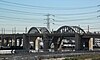
[Date designated]: January 30, 2008
[Locality]: E. 6th St. between Mateo St. and S. Boyle Ave.
[Neighborhood]: Boyle Heights
[Description]: Built in 1932, the 6th Street viaduct was demolished in 2016 due to concerns over seismic instability. A new replacement bridge will be built.
(Current and former Historic-Cultural Monuments) -
[HCM #]: 908
[Landmark name]: Riverside-Figueroa Bridge, No. 53C0160
[Image]:
[Date designated]: January 30, 2008
[Locality]: Riverside Dr between Barclay St and N San Fernando Rd
[Neighborhood]: Cypress Park
[Description]: Demolished in 2015
(Current and former Historic-Cultural Monuments) -
[HCM #]: 931
[Landmark name]: Castle Crag (house)
[Image]:
[Date designated]: July 29, 2008
[Locality]: 5027 El Verano Avenue
[Neighborhood]: Eagle Rock
[Description]: Queen Anne-style early Pioneer residence structure
(Current and former Historic-Cultural Monuments) -
[HCM #]: 944
[Landmark name]: Hermon Car Wall
[Image]:
[Date designated]: January 28, 2009
[Locality]: 400 former block Pullman Ave. (east of Monterey Rd.)34°6′2.19″N 118°11′20.12″W / 34.1006083°N 118.1889222°W / 34.1006083; -118.1889222 (944. Hermon Car Wall)
[Neighborhood]: Hermon
[Description]: Also called "The Model T Wall". In the style of Antoni Gaudí, Albert Emmanuel Sederquist from 1932 to the 1940s built this retaining wall sculpture with parts of cars and a schoolhouse destroyed in an earthquake. When designated, one of three folk art LAHCM's, along with #15 Watts Towers and #184 Tower of Wooden Pallets (demolished) built by Daniel Van Meter.
(Current and former Historic-Cultural Monuments) -
[HCM #]: 951
[Landmark name]: James F. Real Studio Office
[Image]:
[Date designated]: April 22, 2009
[Locality]: 77 Patrician Way34°8′33.31″N 118°10′57.1″W / 34.1425861°N 118.182528°W / 34.1425861; -118.182528 (951. James F. Real Studio Office)
[Neighborhood]: Eagle Rock
[Description]: Late Modern, first "Thin Shell" type in L.A., 1958.
(Current and former Historic-Cultural Monuments) -
[HCM #]: 982
[Landmark name]: Gless Farmhouse
[Image]:
[Date designated]:
[Locality]: 131 S. Boyle St.
[Neighborhood]: Boyle Heights
[Description]: Queen Anne style, 1887.
(Current and former Historic-Cultural Monuments) -
[HCM #]: 989
[Landmark name]: Coons Residence
[Image]:
[Date designated]: October 5, 2010
[Locality]: 2071 W. Escarpa Drive
[Neighborhood]: Eagle Rock
[Description]: Two-story Spanish Colonial Revival style home for Arthur Coons, the President of Occidental College from 1946 to 1965.
(Current and former Historic-Cultural Monuments) -
[HCM #]: 1004
[Landmark name]: Richard Henry Dana Branch Library
[Image]: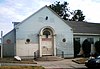
[Date designated]: September 14, 2011
[Locality]: 3320 Pepper Street
[Neighborhood]: Cypress Park
[Description]: Los Angeles branch library built in 1926, designed in the Georgian Revival Style by architect Harry Sims Bent. Named for author of Two Years Before the Mast.
(Current and former Historic-Cultural Monuments) -
[HCM #]: 1009
[Landmark name]: Heritage Square Museum
[Image]:
[Date designated]: December 16, 2011
[Locality]: 3800 Homer Street
[Neighborhood]: Montecito Heights
[Description]: Established in 1969, Heritage Square is the home of eight historic buildings, train cars and a 1920s pharmacy.
(Current and former Historic-Cultural Monuments) -
[HCM #]: 1017
[Landmark name]: Young-Gribling Residence
[Image]:
[Date designated]: April 25, 2012
[Locality]: 3320 N. Griffin Avenue
[Neighborhood]: Montecito Heights
[Description]: Built in 1885, this Victorian house was designed by the architect Robert Brown Young for his brother, A. J. From 1902 until 1954 it was the home of building contractor Arthur Gribling and his wife, Mabel.
(Current and former Historic-Cultural Monuments) -
[Code]: 2447
[Landmark name]: Binford Residence
[Image]:
[Date designated]:
[Locality]: 2200-2212 Eastlake Ave. & 3201 Baldwin St.
[Neighborhood]: Lincoln Heights
[Description]:
(Non-HCM historic sites recognized by state and nation) -
[Code]: 2454
[Landmark name]: Schliebitz Residence
[Image]:
[Date designated]:
[Locality]: 2063 Griffin Ave.
[Neighborhood]: Lincoln Heights
[Description]:
(Non-HCM historic sites recognized by state and nation) -
[Code]: 2455
[Landmark name]: Nicol Residence
[Image]:
[Date designated]:
[Locality]: 2309 Hancock St.
[Neighborhood]: Lincoln Heights
[Description]:
(Non-HCM historic sites recognized by state and nation) -
[Code]: 2456
[Landmark name]: Lemberger - Sigler Residence
[Image]:
[Date designated]:
[Locality]: 2800 Manitou Ave.
[Neighborhood]: Lincoln Heights
[Description]:
(Non-HCM historic sites recognized by state and nation) -
[Code]: 2457
[Landmark name]: Todd Residence
[Image]:
[Date designated]:
[Locality]: 2808 Manitou Ave.
[Neighborhood]: Lincoln Heights
[Description]:
(Non-HCM historic sites recognized by state and nation) -
[Code]: 2458
[Landmark name]: Stoltenberg Residence
[Image]:
[Date designated]:
[Locality]: 2901-2907 Manitou Ave.
[Neighborhood]: Lincoln Heights
[Description]:
(Non-HCM historic sites recognized by state and nation) -
[Code]: 2460
[Landmark name]: Olin Residence
[Image]:
[Date designated]:
[Locality]: 2622-2624 Mozart St.
[Neighborhood]: Lincoln Heights
[Description]:
(Non-HCM historic sites recognized by state and nation) -
[Code]: 2475
[Landmark name]: Girard-Vai Residence
[Image]:
[Date designated]:
[Locality]: 2113-21131⁄2 Parkside Ave.
[Neighborhood]: Lincoln Heights
[Description]:
(Non-HCM historic sites recognized by state and nation) -
[Code]: 2476
[Landmark name]: Clark-Doody Residence
[Image]:
[Date designated]:
[Locality]: 2139-2141 Parkside Ave.
[Neighborhood]: Lincoln Heights
[Description]:
(Non-HCM historic sites recognized by state and nation) -
[Code]: 2502
[Landmark name]: Richard Henry Dana Branch Library
[Image]:
[Date designated]:
[Locality]: 3320 Pepper Ave.
[Neighborhood]: Cypress Park
[Description]: This former Los Angeles Public Library branch was built in 1926 and was designed by architect Harry S. Bent in the Georgian Revival style.
(Non-HCM historic sites recognized by state and nation) -
[Code]: 2537
[Landmark name]: Foyen Residence
[Image]:
[Date designated]:
[Locality]: 2242 Workman St.
[Neighborhood]: Lincoln Heights
[Description]:
(Non-HCM historic sites recognized by state and nation)
New Random Display Display All Items(163)