


-
[SL. No.]: S-GJ-1
[Description]: Amritavarshini Vav
[Location]: Panchkuva
[Address]: Ahmedabad
[District]: Ahmedabad
[Coordinates]: 23°01′30″N 72°35′50″E / 23.02495°N 72.5972°E / 23.02495; 72.5972 (SL. No. S-GJ-1)
[Image]: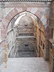
 More images
(List of state protected monuments) -
[SL. No.]: S-GJ-2
[Description]: Dutch Tomb
[Location]: Near Kankaria Lake
[Address]: Ahmedabad
[District]: Ahmedabad district
[Coordinates]: 23°00′22″N 72°36′05″E / 23.006249°N 72.601336°E / 23.006249; 72.601336 (SL. No. S-GJ-2)
[Image]: More images
(List of state protected monuments) -
[SL. No.]: S-GJ-3
[Description]: Khan Talav Having Water Let out
[Location]:
[Address]: Dholka
[District]: Ahmedabad district
[Coordinates]: 22°44′04″N 72°25′47″E / 22.7345065°N 72.4296749°E / 22.7345065; 72.4296749 (SL. No. S-GJ-3)
[Image]:
(List of state protected monuments) -
[SL. No.]: S-GJ-4
[Description]: Ancient Masjid (Mosque)
[Location]:
[Address]: Isanpur
[District]: Ahmedabad district
[Coordinates]:
[Image]:
(List of state protected monuments) -
[SL. No.]: S-GJ-5
[Description]: Ancient Step Well
[Location]:
[Address]: Kathvada
[District]: Ahmedabad district
[Coordinates]: 23°03′28″N 72°42′17″E / 23.057701°N 72.704678°E / 23.057701; 72.704678 (SL. No. S-GJ-5)
[Image]:
(List of state protected monuments) -
[SL. No.]: S-GJ-6
[Description]: Timbo (Mound)
[Location]:
[Address]: Babra
[District]: Amreli
[Coordinates]:
[Image]:
(List of state protected monuments) -
[SL. No.]: S-GJ-7
[Description]: Adnath Temple
[Location]:
[Address]: Adpokar
[District]: Gir Somnath
[Coordinates]: 20°51′04″N 70°47′28″E / 20.851139°N 70.791000°E / 20.851139; 70.791000 (SL. No. S-GJ-7)
[Image]:
(List of state protected monuments) -
[SL. No.]: S-GJ-8
[Description]: Two inscriptions of Kandhmatad
[Location]:
[Address]: Juni Fafani (Near Dolasa)
[District]: Gir Somnath
[Coordinates]:
[Image]:
(List of state protected monuments) -
[SL. No.]: S-GJ-9
[Description]: Ganganath Mahadev Temple
[Location]:
[Address]: Tosan
[District]: Gir Somnath
[Coordinates]:
[Image]:
(List of state protected monuments) -
[SL. No.]: S-GJ-10
[Description]: Ancient Shiv Temple
[Location]:
[Address]: Kasara
[District]: Banaskantha
[Coordinates]:
[Image]:
(List of state protected monuments) -
[SL. No.]: S-GJ-11
[Description]: Kumbheshwar Mahadev
[Location]:
[Address]: Kumbhariya
[District]: Banaskantha
[Coordinates]: 24°19′26″N 72°51′39″E / 24.3240095°N 72.8609501°E / 24.3240095; 72.8609501 (SL. No. S-GJ-11)
[Image]: More images
(List of state protected monuments) -
[SL. No.]: S-GJ-12
[Description]: Temple No.1 Near Kantivas
[Location]:
[Address]: Tarsang Forest
[District]: Banaskantha
[Coordinates]:
[Image]:
(List of state protected monuments) -
[SL. No.]: S-GJ-13
[Description]: Temple No.2
[Location]:
[Address]: Tarsang Forest
[District]: Banaskantha
[Coordinates]:
[Image]:
(List of state protected monuments) -
[SL. No.]: S-GJ-14
[Description]: Temple No.3
[Location]:
[Address]: Tarsang Forest
[District]: Banaskantha
[Coordinates]:
[Image]:
(List of state protected monuments) -
[SL. No.]: S-GJ-15
[Description]: Temple No.4
[Location]:
[Address]: Tarsang Forest
[District]: Banaskantha
[Coordinates]:
[Image]:
(List of state protected monuments) -
[SL. No.]: S-GJ-16
[Description]: Temple No.5
[Location]:
[Address]: Tarsang Forest
[District]: Banaskantha
[Coordinates]:
[Image]:
(List of state protected monuments) -
[SL. No.]: S-GJ-17
[Description]: Temple No.6
[Location]:
[Address]: Tarsang Forest
[District]: Banaskantha
[Coordinates]:
[Image]:
(List of state protected monuments) -
[SL. No.]: S-GJ-18
[Description]: Temple No.1 (near Mahudi)
[Location]:
[Address]: Tarsang Forest (Near Mahudi)
[District]: Banaskantha
[Coordinates]:
[Image]:
(List of state protected monuments) -
[SL. No.]: S-GJ-19
[Description]: Temple No. 2
[Location]:
[Address]: Tarsang Forest (Near Mahudi)
[District]: Banaskantha
[Coordinates]:
[Image]:
(List of state protected monuments) -
[SL. No.]: S-GJ-20
[Description]: Temple No.3
[Location]:
[Address]: Tarsang Forest (Near Mahudi)
[District]: Banaskantha
[Coordinates]:
[Image]:
(List of state protected monuments) -
[SL. No.]: S-GJ-21
[Description]: Temple No.4
[Location]:
[Address]: Tarsang Forest (Near Mahudi)
[District]: Banaskantha
[Coordinates]:
[Image]:
(List of state protected monuments) -
[SL. No.]: S-GJ-22
[Description]: Stepwell
[Location]:
[Address]: Hadad
[District]: Banaskantha
[Coordinates]:
[Image]:
(List of state protected monuments) -
[SL. No.]: S-GJ-23
[Description]: Ancient Temple
[Location]:
[Address]: Hadad
[District]: Banaskantha
[Coordinates]: 24°15′59″N 72°58′30″E / 24.266521°N 72.974869°E / 24.266521; 72.974869 (SL. No. S-GJ-23)
[Image]:
(List of state protected monuments) -
[SL. No.]: S-GJ-24
[Description]: Muleshwar Mahadev Temple
[Location]:
[Address]: Padan
[District]: Banaskantha
[Coordinates]: 24°17′09″N 71°18′46″E / 24.2858581°N 71.3127217°E / 24.2858581; 71.3127217 (SL. No. S-GJ-24)
[Image]:
(List of state protected monuments) -
[SL. No.]: S-GJ-25
[Description]: Kapileshwar Mahadev Temple
[Location]:
[Address]: Vav
[District]: Banaskantha
[Coordinates]: 24°24′04″N 71°29′06″E / 24.401088°N 71.4850003°E / 24.401088; 71.4850003 (SL. No. S-GJ-25)
[Image]:
(List of state protected monuments) -
[SL. No.]: S-GJ-26
[Description]: Mithi Vav
[Location]:
[Address]: Palanpur
[District]: Banaskantha
[Coordinates]: 24°10′27″N 72°25′59″E / 24.174051°N 72.433099°E / 24.174051; 72.433099 (SL. No. S-GJ-26)
[Image]: More images
(List of state protected monuments) -
[SL. No.]: S-GJ-27
[Description]: Zaloragadh Timbo/Mound
[Location]:
[Address]: Zaloragadh (Radhanpur)
[District]: Patan
[Coordinates]:
[Image]:
(List of state protected monuments) -
[SL. No.]: S-GJ-28
[Description]: Kadia Dungar Caves
[Location]:
[Address]: Zazpor
[District]: Bharuch
[Coordinates]: 21°40′25″N 73°16′20″E / 21.673742°N 73.272278°E / 21.673742; 73.272278 (SL. No. S-GJ-28)
[Image]: More images
(List of state protected monuments) -
[SL. No.]: S-GJ-29
[Description]: Harpiya Timbo (Harappan Mound)
[Location]:
[Address]: Budhel
[District]: Bhavnagar
[Coordinates]: 21°40′57″N 72°09′33″E / 21.682580°N 72.159211°E / 21.682580; 72.159211 (SL. No. S-GJ-29)
[Image]:
(List of state protected monuments) -
[SL. No.]: S-GJ-30
[Description]: Ganga Chhatri
[Location]:
[Address]: Bhavnagar
[District]: Bhavnagar
[Coordinates]: 21°46′30″N 72°08′35″E / 21.774995°N 72.1430193°E / 21.774995; 72.1430193 (SL. No. S-GJ-30)
[Image]:
(List of state protected monuments) -
[SL. No.]: S-GJ-31
[Description]: Carvings of old Darbargadh
[Location]:
[Address]: Bhavnagar
[District]: Bhavnagar
[Coordinates]:
[Image]:
(List of state protected monuments) -
[SL. No.]: S-GJ-32
[Description]: Bhavnath Temple
[Location]:
[Address]: Bhavnagar
[District]: Bhavnagar
[Coordinates]: 21°46′40″N 72°08′38″E / 21.7777627°N 72.1439897°E / 21.7777627; 72.1439897 (SL. No. S-GJ-32)
[Image]:
(List of state protected monuments) -
[SL. No.]: S-GJ-33
[Description]: Firangi Deval
[Location]:
[Address]: Kalsar
[District]: Bhavnagar
[Coordinates]: 21°07′17″N 71°53′48″E / 21.121441°N 71.896769°E / 21.121441; 71.896769 (SL. No. S-GJ-33)
[Image]:
(List of state protected monuments) -
[SL. No.]: S-GJ-34
[Description]: Ceiling and Pictures on the wall, Gopnath temple
[Location]:
[Address]: Talaja
[District]: Bhavnagar
[Coordinates]: 21°12′35″N 72°06′21″E / 21.209764°N 72.1058253°E / 21.209764; 72.1058253 (SL. No. S-GJ-34)
[Image]:
(List of state protected monuments) -
[SL. No.]: S-GJ-35
[Description]: Brahma Kund
[Location]:
[Address]: Sihor
[District]: Bhavnagar
[Coordinates]: 21°42′29″N 71°57′38″E / 21.70812°N 71.96056°E / 21.70812; 71.96056 (SL. No. S-GJ-35)
[Image]: More images
(List of state protected monuments) -
[SL. No.]: S-GJ-36
[Description]: Saat Sheri (Satsheri)
[Location]:
[Address]: Sihor
[District]: Bhavnagar
[Coordinates]: 21°42′22″N 71°57′54″E / 21.706075°N 71.96491°E / 21.706075; 71.96491 (SL. No. S-GJ-36)
[Image]:
(List of state protected monuments) -
[SL. No.]: S-GJ-37
[Description]: Minara
[Location]:
[Address]: Loliyana
[District]: Bhavnagar
[Coordinates]: 21°56′32″N 71°47′25″E / 21.9422233°N 71.7901803°E / 21.9422233; 71.7901803 (SL. No. S-GJ-37)
[Image]:
(List of state protected monuments) -
[SL. No.]: S-GJ-38
[Description]: Ancient Temple
[Location]:
[Address]: Gundi
[District]: Bhavnagar
[Coordinates]:
[Image]:
(List of state protected monuments) -
[SL. No.]: S-GJ-39
[Description]: Kund & Toran
[Location]:
[Address]: Kapadvanj
[District]: Kheda
[Coordinates]: 23°01′23″N 73°04′16″E / 23.023108°N 73.071224°E / 23.023108; 73.071224 (SL. No. S-GJ-39)
[Image]:
(List of state protected monuments) -
[SL. No.]: S-GJ-40
[Description]: Vav (Step Well) (Dholikui)
[Location]:
[Address]: Kapadvanj
[District]: Kheda
[Coordinates]: 23°01′24″N 73°04′18″E / 23.02332°N 73.071592°E / 23.02332; 73.071592 (SL. No. S-GJ-40)
[Image]:
(List of state protected monuments) -
[SL. No.]: S-GJ-41
[Description]: Vori Vav
[Location]:
[Address]: Kapadvanj
[District]: Kheda
[Coordinates]:
[Image]:
(List of state protected monuments) -
[SL. No.]: S-GJ-42
[Description]: Mota Todavali Vav
[Location]:
[Address]: Vadthal
[District]: Kheda
[Coordinates]: 22°51′35″N 72°57′26″E / 22.859686°N 72.957166°E / 22.859686; 72.957166 (SL. No. S-GJ-42)
[Image]:
(List of state protected monuments) -
[SL. No.]: S-GJ-43
[Description]: Vav (Step Well)
[Location]:
[Address]: Mahemadavad
[District]: Kheda
[Coordinates]: 22°49′33″N 72°45′17″E / 22.8259162°N 72.7547542°E / 22.8259162; 72.7547542 (SL. No. S-GJ-43)
[Image]:
(List of state protected monuments) -
[SL. No.]: S-GJ-44
[Description]: Bhadrakali Mata Stepwell
[Location]:
[Address]: Umreth
[District]: Anand
[Coordinates]: 22°42′07″N 73°07′01″E / 22.702005°N 73.117057°E / 22.702005; 73.117057 (SL. No. S-GJ-44)
[Image]:
(List of state protected monuments) -
[SL. No.]: S-GJ-45
[Description]: Bhadeshwar Temple
[Location]:
[Address]: Anjar
[District]: Kachchh
[Coordinates]: 23°06′20″N 70°01′45″E / 23.105530°N 70.029239°E / 23.105530; 70.029239 (SL. No. S-GJ-45)
[Image]:
(List of state protected monuments) -
[SL. No.]: S-GJ-46
[Description]: Pictures on the wall of Deputy Collector office (MacMurdo's Bungalow)
[Location]:
[Address]: Anjar
[District]: Kachchh
[Coordinates]: 23°06′41″N 70°01′39″E / 23.11131°N 70.02747°E / 23.11131; 70.02747 (SL. No. S-GJ-46)
[Image]: More images
(List of state protected monuments) -
[SL. No.]: S-GJ-47
[Description]: Shail Gufa (Cave) No.1
[Location]:
[Address]: Deshalpar
[District]: Kachchh
[Coordinates]:
[Image]:
(List of state protected monuments) -
[SL. No.]: S-GJ-48
[Description]: Shail Gufa No.2
[Location]:
[Address]: Deshalpar
[District]: Kachchh
[Coordinates]:
[Image]:
(List of state protected monuments) -
[SL. No.]: S-GJ-49
[Description]: Puareshwar Temple (At Puargadh NR Lakhedi)
[Location]:
[Address]: Manjal
[District]: Kachchh
[Coordinates]: 23°15′26″N 69°23′01″E / 23.257320°N 69.383632°E / 23.257320; 69.383632 (SL. No. S-GJ-49)
[Image]: More images
(List of state protected monuments) -
[SL. No.]: S-GJ-50
[Description]: Vadimedi (Shaiv Madh) (At Puargadh)
[Location]:
[Address]: Manjal
[District]: Kachchh
[Coordinates]: 23°15′30″N 69°22′52″E / 23.2583221°N 69.3811524°E / 23.2583221; 69.3811524 (SL. No. S-GJ-50)
[Image]:
(List of state protected monuments) -
[SL. No.]: S-GJ-51
[Description]: Gates of Kanthkot
[Location]:
[Address]: Kanthkot
[District]: Kachchh
[Coordinates]: 23°29′06″N 70°27′51″E / 23.484946°N 70.464232°E / 23.484946; 70.464232 (SL. No. S-GJ-51)
[Image]: More images
(List of state protected monuments) -
[SL. No.]: S-GJ-52
[Description]: Jain Temple
[Location]:
[Address]: Kanthkot
[District]: Kachchh
[Coordinates]: 23°29′03″N 70°27′52″E / 23.484271°N 70.464307°E / 23.484271; 70.464307 (SL. No. S-GJ-52)
[Image]:
(List of state protected monuments) -
[SL. No.]: S-GJ-53
[Description]: Surya Temple
[Location]:
[Address]: Kanthkot
[District]: Kachchh
[Coordinates]: 23°29′02″N 70°27′47″E / 23.4838318°N 70.4629416°E / 23.4838318; 70.4629416 (SL. No. S-GJ-53)
[Image]:
(List of state protected monuments) -
[SL. No.]: S-GJ-54
[Description]: Shiva Temple
[Location]:
[Address]: Kera
[District]: Kachchh
[Coordinates]: 23°05′06″N 69°35′58″E / 23.085042°N 69.599419°E / 23.085042; 69.599419 (SL. No. S-GJ-54)
[Image]: More images
(List of state protected monuments) -
[SL. No.]: S-GJ-55
[Description]: Ram Kund
[Location]:
[Address]: Bhuj
[District]: Kachchh
[Coordinates]: 23°14′51″N 69°39′50″E / 23.2475852°N 69.6639864°E / 23.2475852; 69.6639864 (SL. No. S-GJ-55)
[Image]: More images
(List of state protected monuments) -
[SL. No.]: S-GJ-56
[Description]: Old Temple
[Location]:
[Address]: Bhadreshwar
[District]: Kachchh
[Coordinates]: 22°54′43″N 69°54′02″E / 22.9118704°N 69.9006877°E / 22.9118704; 69.9006877 (SL. No. S-GJ-56)
[Image]:
(List of state protected monuments) -
[SL. No.]: S-GJ-57
[Description]: Eye No Dero Shiva Temple
[Location]:
[Address]: Chitrod - Mevasa
[District]: Kachchh
[Coordinates]: 23°24′54″N 70°41′50″E / 23.4150194°N 70.6971757°E / 23.4150194; 70.6971757 (SL. No. S-GJ-57)
[Image]:
(List of state protected monuments) -
[SL. No.]: S-GJ-58
[Description]: Shai Gufao/Caves (Siyot Caves)
[Location]:
[Address]: Near Juna Patgadh
[District]: Kachchh
[Coordinates]: 23°44′24″N 68°46′26″E / 23.739917°N 68.773894°E / 23.739917; 68.773894 (SL. No. S-GJ-58)
[Image]:
(List of state protected monuments) -
[SL. No.]: S-GJ-60
[Description]: Mound of Pabhumath
[Location]:
[Address]: Suvai
[District]: Kachchh
[Coordinates]:
[Image]:
(List of state protected monuments) -
[SL. No.]: S-GJ-61
[Description]: Mound of Shobharel
[Location]: in Shobharel river basin, Khadir Island
[Address]: NE of Chanpar village
[District]: Kachchh
[Coordinates]:
[Image]:
(List of state protected monuments) -
[SL. No.]: S-GJ-62
[Description]: Padhargadh
[Location]:
[Address]: Near Puareshwar (Manjal)
[District]: Kachchh
[Coordinates]: 23°15′22″N 69°22′49″E / 23.256173°N 69.380265°E / 23.256173; 69.380265 (SL. No. S-GJ-62)
[Image]:
(List of state protected monuments) -
[SL. No.]: S-GJ-63
[Description]: Lakhpat Fort
[Location]:
[Address]: Lakhpat
[District]: Kachchh
[Coordinates]: 23°49′25″N 68°46′48″E / 23.823590°N 68.780082°E / 23.823590; 68.780082 (SL. No. S-GJ-63)
[Image]: More images
(List of state protected monuments) -
[SL. No.]: S-GJ-64
[Description]: Bhuvadeshwar Mahadev Temple
[Location]:
[Address]: Bhuvad
[District]: Kachchh
[Coordinates]: 23°01′02″N 69°53′56″E / 23.0171136°N 69.8989221°E / 23.0171136; 69.8989221 (SL. No. S-GJ-64)
[Image]: More images
(List of state protected monuments) -
[SL. No.]: S-GJ-65
[Description]: Gurdwara
[Location]:
[Address]: Lakhpat
[District]: Kachchh
[Coordinates]: 23°49′34″N 68°46′41″E / 23.8261829°N 68.7780873°E / 23.8261829; 68.7780873 (SL. No. S-GJ-65)
[Image]: More images
(List of state protected monuments) -
[SL. No.]: S-GJ-66
[Description]: Kirti Stambh (Deva Manek Stambh)
[Location]:
[Address]: Machharda (Kalavad)
[District]: Jamnagar
[Coordinates]: 22°05′08″N 70°19′47″E / 22.085471°N 70.329759°E / 22.085471; 70.329759 (SL. No. S-GJ-66)
[Image]:
(List of state protected monuments) -
[SL. No.]: S-GJ-67
[Description]: Ancient Temple
[Location]: ?
[Address]: Datrana
[District]: Devbhumi Dwarka
[Coordinates]:
[Image]:
(List of state protected monuments) -
[SL. No.]: S-GJ-68
[Description]: Shail Gufa of Alech Patan/Khapra Kodia
[Location]: ?
[Address]: Patan (Jamjodhpur)
[District]: Jamnagar
[Coordinates]:
[Image]:
(List of state protected monuments) -
[SL. No.]: S-GJ-69
[Description]: Mound (Amra)
[Location]:
[Address]: Amra
[District]: Jamnagar
[Coordinates]: 22°24′47″N 69°55′22″E / 22.412945°N 69.922888°E / 22.412945; 69.922888 (SL. No. S-GJ-69)
[Image]:
(List of state protected monuments) -
[SL. No.]: S-GJ-70
[Description]: Shiv Temple (Khimeshwar Mahadev)
[Location]:
[Address]: Khimrana
[District]: Jamnagar
[Coordinates]: 22°28′25″N 70°09′52″E / 22.4737147°N 70.1644184°E / 22.4737147; 70.1644184 (SL. No. S-GJ-70)
[Image]:
(List of state protected monuments) -
[SL. No.]: S-GJ-71
[Description]: Kotho (Bhujio)/Rampart
[Location]:
[Address]: Jamnagar
[District]: Jamnagar
[Coordinates]: 22°27′45″N 70°04′09″E / 22.4624302°N 70.0692623°E / 22.4624302; 70.0692623 (SL. No. S-GJ-71)
[Image]:
(List of state protected monuments) -
[SL. No.]: S-GJ-72
[Description]: Khambhalia Gate
[Location]:
[Address]: Jamnagar
[District]: Jamnagar
[Coordinates]: 22°27′39″N 70°04′11″E / 22.4609646°N 70.0696642°E / 22.4609646; 70.0696642 (SL. No. S-GJ-72)
[Image]: More images
(List of state protected monuments) -
[SL. No.]: S-GJ-73
[Description]: Inscription of Juma Masjid
[Location]:
[Address]: Jamnagar
[District]: Jamnagar
[Coordinates]: 22°27′48″N 70°04′39″E / 22.4634567°N 70.0774751°E / 22.4634567; 70.0774751 (SL. No. S-GJ-73)
[Image]:
(List of state protected monuments) -
[SL. No.]: S-GJ-74
[Description]: Nagnath Temple
[Location]:
[Address]: Jamnagar
[District]: Jamnagar
[Coordinates]:
[Image]:
(List of state protected monuments) -
[SL. No.]: S-GJ-75
[Description]: Lakhota Tower
[Location]:
[Address]: Jamanagar
[District]: Jamnagar
[Coordinates]: 22°27′56″N 70°03′56″E / 22.4654298°N 70.0654476°E / 22.4654298; 70.0654476 (SL. No. S-GJ-75)
[Image]:
(List of state protected monuments) -
[SL. No.]: S-GJ-76
[Description]: Mound (Narmana)
[Location]:
[Address]: Narmana
[District]: Jamnagar
[Coordinates]: 22°05′24″N 70°09′08″E / 22.089959°N 70.152114°E / 22.089959; 70.152114 (SL. No. S-GJ-76)
[Image]:
(List of state protected monuments) -
[SL. No.]: S-GJ-77
[Description]: Mound (Bed)
[Location]:
[Address]: Bed
[District]: Jamnagar
[Coordinates]: 22°26′49″N 69°53′57″E / 22.4470308°N 69.8992847°E / 22.4470308; 69.8992847 (SL. No. S-GJ-77)
[Image]:
(List of state protected monuments) -
[SL. No.]: S-GJ-78
[Description]: Mound (Moda)
[Location]:
[Address]: Moda
[District]: Jamnagar
[Coordinates]: 22°26′15″N 70°16′48″E / 22.437428°N 70.280115°E / 22.437428; 70.280115 (SL. No. S-GJ-78)
[Image]:
(List of state protected monuments) -
[SL. No.]: S-GJ-79
[Description]: Mound (Lakhabaval)
[Location]:
[Address]: Lakhabawal
[District]: Jamnagar
[Coordinates]: 22°25′13″N 69°59′37″E / 22.4201913°N 69.9936546°E / 22.4201913; 69.9936546 (SL. No. S-GJ-79)
[Image]:
(List of state protected monuments) -
[SL. No.]: S-GJ-80
[Description]: Mound (Vasai)
[Location]:
[Address]: Vasai
[District]: Jamnagar
[Coordinates]: 22°04′00″N 70°00′00″E / 22.06668°N 70°E / 22.06668; 70 (SL. No. S-GJ-80)
[Image]:
(List of state protected monuments) -
[SL. No.]: S-GJ-81
[Description]: Stone Memorial Inscription & Battlefield
[Location]:
[Address]: Shekhpat
[District]: Jamnagar
[Coordinates]:
[Image]:
(List of state protected monuments) -
[SL. No.]: S-GJ-82
[Description]: Kotho
[Location]:
[Address]: Jodiya
[District]: Jamnagar
[Coordinates]:
[Image]:
(List of state protected monuments) -
[SL. No.]: S-GJ-83
[Description]: Kalika Mata Temple
[Location]:
[Address]: Dhrasan Vel
[District]: Devbhumi Dwarka
[Coordinates]:
[Image]:
(List of state protected monuments) -
[SL. No.]: S-GJ-84
[Description]: Stone Memorial of Bhuchar Mori Deri & Battlefield
[Location]:
[Address]: Dhrol
[District]: Jamnagar
[Coordinates]: 22°34′58″N 70°23′52″E / 22.58277°N 70.397666°E / 22.58277; 70.397666 (SL. No. S-GJ-84)
[Image]: More images
(List of state protected monuments) -
[SL. No.]: S-GJ-85
[Description]: Forts Nr. Kileshwar
[Location]: Rav no Nes
[Address]: Ghumli
[District]: Devbhumi Dwarka
[Coordinates]: 21°50′24″N 69°44′44″E / 21.839941°N 69.745526°E / 21.839941; 69.745526 (SL. No. S-GJ-85)
[Image]:
(List of state protected monuments) -
[SL. No.]: S-GJ-86
[Description]: Ganesh Temple
[Location]:
[Address]: Ghumli
[District]: Devbhumi Dwarka
[Coordinates]: 21°52′59″N 69°45′39″E / 21.8831914°N 69.7607914°E / 21.8831914; 69.7607914 (SL. No. S-GJ-86)
[Image]:
(List of state protected monuments) -
[SL. No.]: S-GJ-87
[Description]: Navlakha Temple
[Location]:
[Address]: Ghumli
[District]: Devbhumi Dwarka
[Coordinates]: 21°52′59″N 69°45′39″E / 21.8831914°N 69.7607914°E / 21.8831914; 69.7607914 (SL. No. S-GJ-87)
[Image]: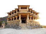 More images
(List of state protected monuments) -
[SL. No.]: S-GJ-88
[Description]: Ancient Temple on the Bank of Chhelsar Talav
[Location]:
[Address]: Ghumli
[District]: Devbhumi Dwarka
[Coordinates]: 21°53′07″N 69°45′22″E / 21.885188°N 69.756156°E / 21.885188; 69.756156 (SL. No. S-GJ-88)
[Image]:
(List of state protected monuments) -
[SL. No.]: S-GJ-89
[Description]: Rampol Gates
[Location]:
[Address]: Ghumli
[District]: Devbhumi Dwarka
[Coordinates]:
[Image]:
(List of state protected monuments) -
[SL. No.]: S-GJ-90
[Description]: Vikiya Vav
[Location]:
[Address]: Ghumli
[District]: Devbhumi Dwarka
[Coordinates]: 21°52′59″N 69°45′39″E / 21.8831914°N 69.7607914°E / 21.8831914; 69.7607914 (SL. No. S-GJ-90)
[Image]:
(List of state protected monuments) -
[SL. No.]: S-GJ-91
[Description]: Son Kansari
[Location]:
[Address]: Ghumli
[District]: Devbhumi Dwarka
[Coordinates]: 21°52′47″N 69°45′05″E / 21.8796727°N 69.751282°E / 21.8796727; 69.751282 (SL. No. S-GJ-91)
[Image]:
(List of state protected monuments) -
[SL. No.]: S-GJ-92
[Description]: Five Temples
[Location]:
[Address]: Pachhtar
[District]: Devbhumi Dwarka
[Coordinates]: 21°52′05″N 69°40′52″E / 21.8681732°N 69.6811063°E / 21.8681732; 69.6811063 (SL. No. S-GJ-92)
[Image]:
(List of state protected monuments) -
[SL. No.]: S-GJ-93
[Description]: Bhimeshwar Mahadev Temples
[Location]:
[Address]: Near Pachhtar
[District]: Devbhumi Dwarka
[Coordinates]: 21°52′29″N 69°40′36″E / 21.8748125°N 69.6765652°E / 21.8748125; 69.6765652 (SL. No. S-GJ-93)
[Image]:
(List of state protected monuments) -
[SL. No.]: S-GJ-94
[Description]: Two Bhavaneshwar Temples
[Location]:
[Address]: Bhavaneshwar
[District]: Devbhumi Dwarka
[Coordinates]: 21°53′13″N 69°41′13″E / 21.887039°N 69.6869736°E / 21.887039; 69.6869736 (SL. No. S-GJ-94)
[Image]:
(List of state protected monuments) -
[SL. No.]: S-GJ-95
[Description]: Fort
[Location]:
[Address]: Modpar
[District]: Devbhumi Dwarka
[Coordinates]: 21°51′14″N 69°48′31″E / 21.853779°N 69.808591°E / 21.853779; 69.808591 (SL. No. S-GJ-95)
[Image]: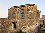 More images
(List of state protected monuments) -
[SL. No.]: S-GJ-96
[Description]: Stepwell
[Location]:
[Address]: Modpar
[District]: Devbhumi Dwarka
[Coordinates]:
[Image]: More images
(List of state protected monuments) -
[SL. No.]: S-GJ-97
[Description]: Dhingeshwar Mahadev Temple & Shail Gufao
[Location]: Dhingeshwar??
[Address]: Modpar
[District]: Devbhumi Dwarka
[Coordinates]: 21°43′09″N 69°42′24″E / 21.7190608°N 69.7067376°E / 21.7190608; 69.7067376 (SL. No. S-GJ-97)
[Image]:
(List of state protected monuments) -
[SL. No.]: S-GJ-98
[Description]: Panoti Temple
[Location]:
[Address]: Hathla
[District]: Devbhumi Dwarka
[Coordinates]: 21°51′13″N 69°37′20″E / 21.8534744°N 69.622156°E / 21.8534744; 69.622156 (SL. No. S-GJ-98)
[Image]:
(List of state protected monuments) -
[SL. No.]: S-GJ-99
[Description]: Shani Vav
[Location]:
[Address]: Hathla
[District]: Devbhumi Dwarka
[Coordinates]: 21°51′12″N 69°37′20″E / 21.8534634°N 69.622288°E / 21.8534634; 69.622288 (SL. No. S-GJ-99)
[Image]:
(List of state protected monuments) -
[SL. No.]: S-GJ-100
[Description]: Mound (Modpar)
[Location]:
[Address]: Modpar (Lalpur)
[District]: Jamnagar
[Coordinates]:
[Image]:
(List of state protected monuments) -
[SL. No.]: S-GJ-101
[Description]: Temple & Two Inscriptions (Ajara Parshwanath)
[Location]:
[Address]: Ajara (Una)
[District]: Gir Somnath
[Coordinates]: 20°47′28″N 71°03′52″E / 20.791102°N 71.064356°E / 20.791102; 71.064356 (SL. No. S-GJ-101)
[Image]:
(List of state protected monuments) -
[SL. No.]: S-GJ-102
[Description]: Seven Basins of Hot Water (Kunds)
[Location]: Tulsishyam
[Address]: Una-Tulsishyam Road
[District]: Gir Somnath
[Coordinates]: 21°03′03″N 71°01′28″E / 21.0508614°N 71.024565°E / 21.0508614; 71.024565 (SL. No. S-GJ-102)
[Image]:
(List of state protected monuments) -
[SL. No.]: S-GJ-103
[Description]: Stone Inscriptions Near Talav
[Location]:
[Address]: Una-Tuslishyam Road
[District]: Gir Somnath
[Coordinates]:
[Image]:
(List of state protected monuments) -
[SL. No.]: S-GJ-104
[Description]: Bhimchas
[Location]:
[Address]: Una-Tulsishyam Road
[District]: Junagadh
[Coordinates]: 21°03′25″N 71°02′40″E / 21.0570548°N 71.044569°E / 21.0570548; 71.044569 (SL. No. S-GJ-104)
[Image]:
(List of state protected monuments) -
[SL. No.]: S-GJ-105
[Description]: Gupta Prayag
[Location]:
[Address]: Una
[District]: Junagadh
[Coordinates]:
[Image]:
(List of state protected monuments) -
[SL. No.]: S-GJ-106
[Description]: Gupta Prayag Kund
[Location]:
[Address]: Una
[District]: Junagadh
[Coordinates]: 20°45′08″N 70°59′58″E / 20.752255°N 70.999415°E / 20.752255; 70.999415 (SL. No. S-GJ-106)
[Image]:
(List of state protected monuments) -
[SL. No.]: S-GJ-107
[Description]: Jumma Masjid (Mosque)
[Location]:
[Address]: Delvada
[District]: Gir Somnath
[Coordinates]:
[Image]:
(List of state protected monuments) -
[SL. No.]: S-GJ-108
[Description]: Minaravali Masjid
[Location]:
[Address]: Delvada
[District]: Gir Somnath
[Coordinates]: 20°46′29″N 71°02′43″E / 20.7748384°N 71.0454019°E / 20.7748384; 71.0454019 (SL. No. S-GJ-108)
[Image]:
(List of state protected monuments) -
[SL. No.]: S-GJ-109
[Description]: Vejal Kotho
[Location]:
[Address]: Delvada
[District]: Gir Somnath
[Coordinates]:
[Image]:
(List of state protected monuments) -
[SL. No.]: S-GJ-110
[Description]: Shah Kotho
[Location]:
[Address]: Delvada
[District]: Gir Somnath
[Coordinates]:
[Image]:
(List of state protected monuments) -
[SL. No.]: S-GJ-111
[Description]: Sana Caves
[Location]:
[Address]: Shana - Vankia (Una)
[District]: Gir Somnath
[Coordinates]: 20°57′44″N 71°12′03″E / 20.962136°N 71.200917°E / 20.962136; 71.200917 (SL. No. S-GJ-111)
[Image]:
(List of state protected monuments) -
[SL. No.]: S-GJ-112
[Description]: Two Stone Inscriptions on Jumma Masjid
[Location]:
[Address]: Kutiyana
[District]: Porbandar
[Coordinates]:
[Image]:
(List of state protected monuments) -
[SL. No.]: S-GJ-113
[Description]: Two Idols of Kshetrapal At Vav (Pujari Vav)
[Location]:
[Address]: Kutiyana
[District]: Porbandar
[Coordinates]: 21°37′14″N 69°58′15″E / 21.6206631°N 69.9709216°E / 21.6206631; 69.9709216 (SL. No. S-GJ-113)
[Image]:
(List of state protected monuments) -
[SL. No.]: S-GJ-114
[Description]: Adi Kadi Vav
[Location]: Uparkot
[Address]: Junagadh
[District]: Junagadh
[Coordinates]: 21°31′37″N 70°28′11″E / 21.5268301°N 70.4696315°E / 21.5268301; 70.4696315 (SL. No. S-GJ-114)
[Image]: More images
(List of state protected monuments) -
[SL. No.]: S-GJ-115
[Description]: Jumma Masjid & /Cannon (Neelam And Kadanal)
[Location]: Uparkot
[Address]: Junagadh
[District]: Junagadh
[Coordinates]: 21°31′29″N 70°28′12″E / 21.524783°N 70.470075°E / 21.524783; 70.470075 (SL. No. S-GJ-115)
[Image]:
(List of state protected monuments) -
[SL. No.]: S-GJ-116
[Description]: Navghan Kuvo (Well)
[Location]: Uparkot
[Address]: Junagadh
[District]: Junagadh
[Coordinates]: 21°31′26″N 70°28′09″E / 21.5238288°N 70.469261°E / 21.5238288; 70.469261 (SL. No. S-GJ-116)
[Image]: More images
(List of state protected monuments) -
[SL. No.]: S-GJ-117
[Description]: Stone Inscription of Ra'Mandlik (Samvat 1507)
[Location]: Uparkot
[Address]: Junagadh
[District]: Junagadh
[Coordinates]:
[Image]:
(List of state protected monuments) -
[SL. No.]: S-GJ-118
[Description]: Laskari Vav
[Location]: Uparkot
[Address]: Junagadh
[District]: Junagadh
[Coordinates]: 21°31′21″N 70°28′09″E / 21.522522°N 70.469182°E / 21.522522; 70.469182 (SL. No. S-GJ-118)
[Image]:
(List of state protected monuments) -
[SL. No.]: S-GJ-119
[Description]: Replica of Ashoka Stone Inscription
[Location]: On the way to Girnar Hill
[Address]: Junagadh
[District]: Junagadh
[Coordinates]:
[Image]:
(List of state protected monuments) -
[SL. No.]: S-GJ-120
[Description]: Damodar Kund
[Location]: On the way to Girnar Hill
[Address]: Junagadh
[District]: Junagadh
[Coordinates]: 21°31′32″N 70°29′04″E / 21.5255966°N 70.4844121°E / 21.5255966; 70.4844121 (SL. No. S-GJ-120)
[Image]: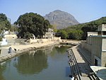 More images
(List of state protected monuments) -
[SL. No.]: S-GJ-121
[Description]: Datar no Chilo
[Location]:
[Address]: Junagadh
[District]: Junagadh
[Coordinates]:
[Image]:
(List of state protected monuments) -
[SL. No.]: S-GJ-122
[Description]: Boria Buddhistic Monument Lakhamedi & Vadi- Lakhamedi
[Location]:
[Address]: Near Bordevi
[District]: Junagadh
[Coordinates]: 21°29′17″N 70°32′33″E / 21.488168°N 70.542550°E / 21.488168; 70.542550 (SL. No. S-GJ-122)
[Image]:
(List of state protected monuments) -
[SL. No.]: S-GJ-123
[Description]: Dhori (Peer) Makbaro
[Location]:
[Address]: Junagadh
[District]: Junagadh
[Coordinates]:
[Image]:
(List of state protected monuments) -
[SL. No.]: S-GJ-124
[Description]: Narsinh Maheta No Choro
[Location]:
[Address]: Junagadh
[District]: Junagadh
[Coordinates]: 21°31′40″N 70°27′31″E / 21.5277873°N 70.4587082°E / 21.5277873; 70.4587082 (SL. No. S-GJ-124)
[Image]:
(List of state protected monuments) -
[SL. No.]: S-GJ-125
[Description]: Makbara of Babi raja Before Nawab Mahotabkhanji (Bahauddin Maqbara)
[Location]:
[Address]: Junagadh
[District]: Junagadh
[Coordinates]: 21°31′39″N 70°27′36″E / 21.527534°N 70.460003°E / 21.527534; 70.460003 (SL. No. S-GJ-125)
[Image]: More images
(List of state protected monuments) -
[SL. No.]: S-GJ-126
[Description]: Makbara of Najubibi with Bara Saiyed (Najibai Maqbara)
[Location]:
[Address]: Junagadh
[District]: Junagadh
[Coordinates]: 21°31′52″N 70°28′04″E / 21.531010°N 70.467888°E / 21.531010; 70.467888 (SL. No. S-GJ-126)
[Image]: More images
(List of state protected monuments) -
[SL. No.]: S-GJ-127
[Description]: Pancheshwar Caves
[Location]:
[Address]: Junagadh
[District]: Junagadh
[Coordinates]:
[Image]:
(List of state protected monuments) -
[SL. No.]: S-GJ-128
[Description]: Mahabat Maqbara
[Location]:
[Address]: Junagadh
[District]: Junagadh
[Coordinates]: 21°31′38″N 70°27′37″E / 21.527282°N 70.460250°E / 21.527282; 70.460250 (SL. No. S-GJ-128)
[Image]: More images
(List of state protected monuments) -
[SL. No.]: S-GJ-129
[Description]: Matri Mata temple
[Location]:
[Address]: Junagadh
[District]: Junagadh
[Coordinates]: 21°31′40″N 70°28′05″E / 21.5278554°N 70.4681831°E / 21.5278554; 70.4681831 (SL. No. S-GJ-129)
[Image]:
(List of state protected monuments) -
[SL. No.]: S-GJ-130
[Description]: Stone Inscription with Mai Gadechi of H. S. 685
[Location]:
[Address]: Junagadh
[District]: Junagadh
[Coordinates]: 21°31′54″N 70°28′00″E / 21.531682°N 70.466668°E / 21.531682; 70.466668 (SL. No. S-GJ-130)
[Image]:
(List of state protected monuments) -
[SL. No.]: S-GJ-131
[Description]: Kalika Mata
[Location]: On Girnar Hill
[Address]: Junagadh
[District]: Junagadh
[Coordinates]:
[Image]:
(List of state protected monuments) -
[SL. No.]: S-GJ-132
[Description]: Guru Datatraya
[Location]: On Girnar Hill
[Address]: Junagadh
[District]: Junagadh
[Coordinates]: 21°31′41″N 70°31′58″E / 21.5279499°N 70.5327564°E / 21.5279499; 70.5327564 (SL. No. S-GJ-132)
[Image]:
(List of state protected monuments) -
[SL. No.]: S-GJ-133
[Description]: Gorakh Mountain Top (Tuk)
[Location]: On Girnar Hill
[Address]: Junagadh
[District]: Junagadh
[Coordinates]: 21°31′40″N 70°31′49″E / 21.5276742°N 70.5302769°E / 21.5276742; 70.5302769 (SL. No. S-GJ-133)
[Image]:
(List of state protected monuments) -
[SL. No.]: S-GJ-134
[Description]: Gaumukhi
[Location]: On Girnar Hill
[Address]: Junagadh
[District]: Junagadh
[Coordinates]: 21°31′40″N 70°31′31″E / 21.527842°N 70.525217°E / 21.527842; 70.525217 (SL. No. S-GJ-134)
[Image]:
(List of state protected monuments) -
[SL. No.]: S-GJ-135
[Description]: Bhim Kund
[Location]: On Girnar Hill
[Address]: Junagadh
[District]: Junagadh
[Coordinates]: 21°31′40″N 70°31′16″E / 21.5278662°N 70.5212349°E / 21.5278662; 70.5212349 (SL. No. S-GJ-135)
[Image]:
(List of state protected monuments) -
[SL. No.]: S-GJ-136
[Description]: Bhairav Jep (Hill Outcrop)
[Location]: On Girnar Hill
[Address]: Junagadh
[District]: Junagadh
[Coordinates]: 21°31′49″N 70°31′28″E / 21.530389°N 70.524399°E / 21.530389; 70.524399 (SL. No. S-GJ-136)
[Image]:
(List of state protected monuments) -
[SL. No.]: S-GJ-137
[Description]: Wooden Sandal (Paduka) Of Ramchandraji
[Location]: On Girnar hill
[Address]: Junagadh
[District]: Junagadh
[Coordinates]: 21°32′04″N 70°31′41″E / 21.5343604°N 70.5280723°E / 21.5343604; 70.5280723 (SL. No. S-GJ-137)
[Image]:
(List of state protected monuments) -
[SL. No.]: S-GJ-138
[Description]: Hanumam Dhara
[Location]: On Girnar Hill
[Address]: Junagadh
[District]: Junagadh
[Coordinates]: 21°32′04″N 70°31′41″E / 21.5343604°N 70.5280723°E / 21.5343604; 70.5280723 (SL. No. S-GJ-138)
[Image]:
(List of state protected monuments) -
[SL. No.]: S-GJ-139
[Description]: Hathi Pagla (Gajapad Kund)
[Location]: On Girnar Hill
[Address]: Junagadh
[District]: Junagadh
[Coordinates]: 21°31′43″N 70°31′24″E / 21.528684°N 70.523223°E / 21.528684; 70.523223 (SL. No. S-GJ-139)
[Image]:
(List of state protected monuments) -
[SL. No.]: S-GJ-140
[Description]: Bhimdeval (Sun temple)
[Location]:
[Address]: Bhimdeval (Talala)
[District]: Gir Somnath
[Coordinates]: 20°57′41″N 70°36′46″E / 20.9614196°N 70.6126982°E / 20.9614196; 70.6126982 (SL. No. S-GJ-140)
[Image]:
(List of state protected monuments) -
[SL. No.]: S-GJ-141
[Description]: Buddhist Stupa - Vajir Panat No Kotho
[Location]:
[Address]: Hadmatiya, Talala
[District]: Gir Somnath
[Coordinates]:
[Image]:
(List of state protected monuments) -
[SL. No.]: S-GJ-142
[Description]: Vishnu Temple
[Location]:
[Address]: Odadar
[District]: Porbandar
[Coordinates]:
[Image]:
(List of state protected monuments) -
[SL. No.]: S-GJ-143
[Description]: Surya Mandir No.1
[Location]:
[Address]: Odadar
[District]: Porbandar
[Coordinates]:
[Image]:
(List of state protected monuments) -
[SL. No.]: S-GJ-144
[Description]: Surya Mandir No.2
[Location]:
[Address]: Odadar
[District]: Porbandar
[Coordinates]:
[Image]:
(List of state protected monuments) -
[SL. No.]: S-GJ-145
[Description]: Khimeshwar Mahadev Temple
[Location]:
[Address]: Kuchhadi
[District]: Porbandar
[Coordinates]: 21°40′56″N 69°32′06″E / 21.6822421°N 69.5351385°E / 21.6822421; 69.5351385 (SL. No. S-GJ-145)
[Image]:
(List of state protected monuments) -
[SL. No.]: S-GJ-146
[Description]: Chadeshwar Mahadev Temple
[Location]:
[Address]: Chhaya
[District]: Porbandar
[Coordinates]: 21°36′26″N 69°39′06″E / 21.6071798°N 69.6516321°E / 21.6071798; 69.6516321 (SL. No. S-GJ-146)
[Image]:
(List of state protected monuments) -
[SL. No.]: S-GJ-147
[Description]: Dhigeshwar Mahadev Temple
[Location]:
[Address]: Chhaya
[District]: Porbandar
[Coordinates]:
[Image]:
(List of state protected monuments) -
[SL. No.]: S-GJ-148
[Description]: House of Smt. Kasturba Gandhi
[Location]:
[Address]: Porbandar
[District]: Porbandar
[Coordinates]:
[Image]:
(List of state protected monuments) -
[SL. No.]: S-GJ-149
[Description]: Sartanji no Choro
[Location]:
[Address]: Porbandar
[District]: Porbandar
[Coordinates]:
[Image]:
(List of state protected monuments) -
[SL. No.]: S-GJ-150
[Description]: Surya Mandir and Sapta Matrika Mandir
[Location]:
[Address]: Boricha
[District]: Porbandar
[Coordinates]:
[Image]:
(List of state protected monuments) -
[SL. No.]: S-GJ-151
[Description]: Jaleshwar Mahadev temple
[Location]:
[Address]: Fatana
[District]: Porbandar
[Coordinates]: 21°53′03″N 69°33′18″E / 21.8841351°N 69.5549999°E / 21.8841351; 69.5549999 (SL. No. S-GJ-151)
[Image]:
(List of state protected monuments) -
[SL. No.]: S-GJ-152
[Description]: Five Temples
[Location]:
[Address]: Balej
[District]: Porbandar
[Coordinates]:
[Image]:
(List of state protected monuments) -
[SL. No.]: S-GJ-153
[Description]: Nandeshwar Mahadev
[Location]:
[Address]: Bokhira
[District]: Porbandar
[Coordinates]:
[Image]:
(List of state protected monuments) -
[SL. No.]: S-GJ-154
[Description]: Chamunda Mata Temple
[Location]:
[Address]: Juna Bokhira
[District]: Porbandar
[Coordinates]: 21°40′09″N 69°36′27″E / 21.6690898°N 69.6074551°E / 21.6690898; 69.6074551 (SL. No. S-GJ-154)
[Image]:
(List of state protected monuments) -
[SL. No.]: S-GJ-155
[Description]: Seven Temples / Saat Mandiro
[Location]:
[Address]: Bhansara
[District]: Porbandar
[Coordinates]:
[Image]:
(List of state protected monuments) -
[SL. No.]: S-GJ-156
[Description]: Ancient Temple (near Madhavrai temple)
[Location]:
[Address]: Madhavpur Ghed
[District]: Porbandar
[Coordinates]: 21°15′22″N 69°57′22″E / 21.2561795°N 69.9561944°E / 21.2561795; 69.9561944 (SL. No. S-GJ-156)
[Image]: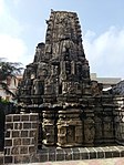
(List of state protected monuments) -
[SL. No.]: S-GJ-157
[Description]: Ancient Temple
[Location]:
[Address]: Miyani
[District]: Porbandar
[Coordinates]: 21°50′28″N 69°22′54″E / 21.841204°N 69.381625°E / 21.841204; 69.381625 (SL. No. S-GJ-157)
[Image]:
(List of state protected monuments) -
[SL. No.]: S-GJ-158
[Description]: Panchayatan Mandir
[Location]:
[Address]: Visavada
[District]: Porbandar
[Coordinates]: 21°46′27″N 69°27′11″E / 21.774084°N 69.452961°E / 21.774084; 69.452961 (SL. No. S-GJ-158)
[Image]:
(List of state protected monuments) -
[SL. No.]: S-GJ-159
[Description]: Vav
[Location]:
[Address]: Visavada
[District]: Porbandar
[Coordinates]: 21°46′27″N 69°27′11″E / 21.774220°N 69.452979°E / 21.774220; 69.452979 (SL. No. S-GJ-159)
[Image]:
(List of state protected monuments) -
[SL. No.]: S-GJ-160
[Description]: Dhanvantari no Palio
[Location]: Moti Dhaneti
[Address]: Maliya Hatina
[District]: Junagadh
[Coordinates]: 21°05′42″N 70°19′12″E / 21.0950504°N 70.3200285°E / 21.0950504; 70.3200285 (SL. No. S-GJ-160)
[Image]:
(List of state protected monuments) -
[SL. No.]: S-GJ-161
[Description]: Memorial Stone of Dah Culture
[Location]:
[Address]: Bagasara-Ghed
[District]: Junagadh
[Coordinates]:
[Image]:
(List of state protected monuments) -
[SL. No.]: S-GJ-162
[Description]: Jhardeshwar Mahadev Temple
[Location]:
[Address]: Amardad (Gadh)
[District]: Porbandar
[Coordinates]:
[Image]:
(List of state protected monuments) -
[SL. No.]: S-GJ-163
[Description]: Bileshwar Mahadev Temple
[Location]:
[Address]: Bileshawar
[District]: Porbandar
[Coordinates]: 21°46′48″N 69°47′10″E / 21.779982°N 69.7860919°E / 21.779982; 69.7860919 (SL. No. S-GJ-163)
[Image]:
(List of state protected monuments) -
[SL. No.]: S-GJ-164
[Description]: Jambuvanti Caves
[Location]:
[Address]: Ranavav
[District]: Porbandar
[Coordinates]: 21°48′56″N 69°39′15″E / 21.815436°N 69.6542973°E / 21.815436; 69.6542973 (SL. No. S-GJ-164)
[Image]:
(List of state protected monuments) -
[SL. No.]: S-GJ-165
[Description]: Nani Vav-no Shilalekh
[Location]:
[Address]: Dhandhusar
[District]: Junagadh
[Coordinates]:
[Image]:
(List of state protected monuments) -
[SL. No.]: S-GJ-166
[Description]: Shamiyana and Ceiling of Jumma Masjid- S.1408
[Location]:
[Address]: Vanthli
[District]: Junagadh
[Coordinates]: 21°28′40″N 70°19′51″E / 21.477727°N 70.3308063°E / 21.477727; 70.3308063 (SL. No. S-GJ-166)
[Image]:
(List of state protected monuments) -
[SL. No.]: S-GJ-167
[Description]: Ra'Khengar Palace (now part of Girnar Jain temples)
[Location]: On Girnar Hill
[Address]: Junagadh
[District]: Junagadh
[Coordinates]: 21°31′37″N 70°31′24″E / 21.5270592°N 70.5233744°E / 21.5270592; 70.5233744 (SL. No. S-GJ-167)
[Image]:
(List of state protected monuments) -
[SL. No.]: S-GJ-168
[Description]: Stone Inscription of Vijayeshwar Mahadev -1346/1408
[Location]:
[Address]: Dhandhusar
[District]: Junagadh
[Coordinates]:
[Image]:
(List of state protected monuments) -
[SL. No.]: S-GJ-169
[Description]: Surya Kund
[Location]:
[Address]: Dhandhusar
[District]: Junagadh
[Coordinates]:
[Image]:
(List of state protected monuments) -
[SL. No.]: S-GJ-170
[Description]: Ra Khengar Vav
[Location]:
[Address]: Vanthli
[District]: Junagadh
[Coordinates]: 21°29′30″N 70°23′00″E / 21.4917454°N 70.3833079°E / 21.4917454; 70.3833079 (SL. No. S-GJ-170)
[Image]:
(List of state protected monuments) -
[SL. No.]: S-GJ-171
[Description]: Caves of Hothal Padmani
[Location]:
[Address]: Jetalpur
[District]: Junagadh
[Coordinates]:
[Image]:
(List of state protected monuments) -
[SL. No.]: S-GJ-172
[Description]: Ancient Temples (Omnath Mahadev temple)
[Location]:
[Address]: Umba
[District]: Gir Somnath
[Coordinates]: 20°59′33″N 70°23′24″E / 20.9924632°N 70.3901089°E / 20.9924632; 70.3901089 (SL. No. S-GJ-172)
[Image]:
(List of state protected monuments) -
[SL. No.]: S-GJ-173
[Description]: Makbaro of Hajarat Shah & Tomb of Malik Ayaz
[Location]:
[Address]: Una
[District]: Gir Somnath
[Coordinates]: 20°49′43″N 71°02′40″E / 20.828611°N 71.044441°E / 20.828611; 71.044441 (SL. No. S-GJ-173)
[Image]:
(List of state protected monuments) -
[SL. No.]: S-GJ-174
[Description]: Kalikamata Temple
[Location]:
[Address]: Navadra
[District]: Gir Somnath
[Coordinates]:
[Image]:
(List of state protected monuments) -
[SL. No.]: S-GJ-175
[Description]: Bilingual Stone Inscription at Gayatri Temple
[Location]:
[Address]: Prashnavada
[District]: Gir Somnath
[Coordinates]: 20°49′15″N 70°33′19″E / 20.8207638°N 70.5553583°E / 20.8207638; 70.5553583 (SL. No. S-GJ-175)
[Image]:
(List of state protected monuments) -
[SL. No.]: S-GJ-176
[Description]: Prachi Kund
[Location]:
[Address]: Una-Veraval Road
[District]: Gir Somnath
[Coordinates]: 20°55′17″N 70°36′31″E / 20.921320°N 70.608722°E / 20.921320; 70.608722 (SL. No. S-GJ-176)
[Image]:
(List of state protected monuments) -
[SL. No.]: S-GJ-177
[Description]: Mool Prachi
[Location]:
[Address]: Una-Veraval Road
[District]: Gir Somnath
[Coordinates]:
[Image]:
(List of state protected monuments) -
[SL. No.]: S-GJ-178
[Description]: Stone Inscription at Kaji Masjid - H.S.902
[Location]:
[Address]: Prabahs Patan
[District]: Junagadh
[Coordinates]: 20°53′31″N 70°24′10″E / 20.8919839°N 70.4028801°E / 20.8919839; 70.4028801 (SL. No. S-GJ-178)
[Image]:
(List of state protected monuments) -
[SL. No.]: S-GJ-179
[Description]: Gorakhnath Mahadev
[Location]: Gorakhmadhi
[Address]:
[District]: Junagadh
[Coordinates]: 20°54′22″N 70°32′05″E / 20.9061411°N 70.5348449°E / 20.9061411; 70.5348449 (SL. No. S-GJ-179)
[Image]:
(List of state protected monuments) -
[SL. No.]: S-GJ-180
[Description]: Jain Temple
[Location]:
[Address]: Prabhas Patan
[District]: Gir Somnath
[Coordinates]:
[Image]:
(List of state protected monuments) -
[SL. No.]: S-GJ-181
[Description]: Talav
[Location]:
[Address]: Prabahs Patan
[District]: Gir Somnath
[Coordinates]:
[Image]:
(List of state protected monuments) -
[SL. No.]: S-GJ-182
[Description]: Mound of Nagara
[Location]:
[Address]: Prabhas Patan
[District]: Gir Somnath
[Coordinates]:
[Image]:
(List of state protected monuments) -
[SL. No.]: S-GJ-183
[Description]: Nek Mahommad Masjid
[Location]:
[Address]: Prabhas Patan
[District]: Gir Somnath
[Coordinates]: 20°53′33″N 70°23′56″E / 20.8924439°N 70.3988115°E / 20.8924439; 70.3988115 (SL. No. S-GJ-183)
[Image]:
(List of state protected monuments) -
[SL. No.]: S-GJ-184
[Description]: Ancient Caves
[Location]:
[Address]: Prabhas Patan
[District]: Gir Somnath
[Coordinates]:
[Image]:
(List of state protected monuments) -
[SL. No.]: S-GJ-185
[Description]: Ancient Jain Temple (Museum Building)
[Location]:
[Address]: Prabhas Patan
[District]: Gir Somnath
[Coordinates]:
[Image]:
(List of state protected monuments) -
[SL. No.]: S-GJ-186
[Description]: Stone Inscription of Bhadrakali Mata
[Location]:
[Address]: Prabhas Patan
[District]: Gir Somnath
[Coordinates]:
[Image]:
(List of state protected monuments) -
[SL. No.]: S-GJ-187
[Description]: Maipuri Masjid
[Location]:
[Address]: Prabahs Patan
[District]: Gir Somnath
[Coordinates]:
[Image]:
(List of state protected monuments) -
[SL. No.]: S-GJ-188
[Description]: Mangaroli Shah Makbaro & Shah Makbaro with Stone Inscription
[Location]:
[Address]: Prabhas Patan
[District]: Gir Somnath
[Coordinates]:
[Image]:
(List of state protected monuments) -
[SL. No.]: S-GJ-189
[Description]: Stone Inscription at Mussaffar Masjid
[Location]:
[Address]: Prabahas Patan
[District]: Gir Somnath
[Coordinates]:
[Image]:
(List of state protected monuments) -
[SL. No.]: S-GJ-190
[Description]: Stone Inscription Near Mota Darwaja
[Location]:
[Address]: Prabahs Patan
[District]: Gir Somnath
[Coordinates]:
[Image]:
(List of state protected monuments) -
[SL. No.]: S-GJ-191
[Description]: Ceiling of Riyapir Masjid
[Location]:
[Address]: Prabhas Patan
[District]: Gir Somnath
[Coordinates]:
[Image]:
(List of state protected monuments) -
[SL. No.]: S-GJ-192
[Description]: Rudreshwar
[Location]:
[Address]: Prabhas Patan
[District]: Gir Somnath
[Coordinates]:
[Image]:
(List of state protected monuments) -
[SL. No.]: S-GJ-193
[Description]: Veneshwar Mahadev Temple
[Location]:
[Address]: Prabhas Patan
[District]: Gir Somnath
[Coordinates]:
[Image]:
(List of state protected monuments) -
[SL. No.]: S-GJ-194
[Description]: Veraval Gate
[Location]:
[Address]: Prabhas Patan
[District]: Gir Somnath
[Coordinates]:
[Image]:
(List of state protected monuments) -
[SL. No.]: S-GJ-195
[Description]: Stone Inscription of Sultan Ahmed (H.S. 905 - 1543)
[Location]:
[Address]: Prabahs Patan
[District]: Gir Somnath
[Coordinates]:
[Image]:
(List of state protected monuments) -
[SL. No.]: S-GJ-196
[Description]: Surya Mandir (Sun Temple)
[Location]: Near Shitala Manadir, Nagar Timba
[Address]: Prabhas Patan
[District]: Gir Somnath
[Coordinates]: 20°53′10″N 70°24′40″E / 20.8860064°N 70.4110282°E / 20.8860064; 70.4110282 (SL. No. S-GJ-196)
[Image]:
(List of state protected monuments) -
[SL. No.]: S-GJ-197
[Description]: Mound of Sav
[Location]:
[Address]: Prabhas Patan
[District]: Gir Somnath
[Coordinates]:
[Image]:
(List of state protected monuments) -
[SL. No.]: S-GJ-198
[Description]: Stone Inscription at Jumma Masjid (H.S.732) (AD 1331-32)
[Location]:
[Address]: Veraval
[District]: Gir Somnath
[Coordinates]:
[Image]:
(List of state protected monuments) -
[SL. No.]: S-GJ-199
[Description]: Stone Inscription at Harshadmata Temple
[Location]:
[Address]: Veraval
[District]: Gir Somnath
[Coordinates]:
[Image]:
(List of state protected monuments) -
[SL. No.]: S-GJ-200
[Description]: Bauddha Guffa (Caves) of Mandore (Mandovar)
[Location]:
[Address]: Savani-Geer
[District]: Gir Somnath
[Coordinates]: 20°58′36″N 70°28′19″E / 20.976763°N 70.472039°E / 20.976763; 70.472039 (SL. No. S-GJ-200)
[Image]:
(List of state protected monuments) -
[SL. No.]: S-GJ-201
[Description]: Chyavan Kund
[Location]:
[Address]: Sutrapada
[District]: Gir Somnath
[Coordinates]: 20°50′21″N 70°29′05″E / 20.839284°N 70.484769°E / 20.839284; 70.484769 (SL. No. S-GJ-201)
[Image]:
(List of state protected monuments) -
[SL. No.]: S-GJ-202
[Description]: Navdurga Temple
[Location]:
[Address]: Sutrapada
[District]: Gir Somnath
[Coordinates]: 20°50′18″N 70°29′01″E / 20.838329°N 70.483629°E / 20.838329; 70.483629 (SL. No. S-GJ-202)
[Image]:
(List of state protected monuments) -
[SL. No.]: S-GJ-203
[Description]: Chaumukhi Vav
[Location]:
[Address]: Chobari
[District]: Surendranagar
[Coordinates]: 22°15′31″N 71°12′23″E / 22.258692°N 71.206389°E / 22.258692; 71.206389 (SL. No. S-GJ-203)
[Image]:
(List of state protected monuments) -
[SL. No.]: S-GJ-204
[Description]: Temple Near Talav
[Location]:
[Address]: Chobari
[District]: Surendranagar
[Coordinates]: 22°15′33″N 71°12′19″E / 22.259094°N 71.205170°E / 22.259094; 71.205170 (SL. No. S-GJ-204)
[Image]:
(List of state protected monuments) -
[SL. No.]: S-GJ-205
[Description]: Tarnetar Temple
[Location]:
[Address]: Thangadh
[District]: Surendranagar
[Coordinates]: 22°38′43″N 71°12′40″E / 22.645387°N 71.211115°E / 22.645387; 71.211115 (SL. No. S-GJ-205)
[Image]:
(List of state protected monuments) -
[SL. No.]: S-GJ-206
[Description]: Munibaba Temple (Munim deval)
[Location]:
[Address]: Thangadh
[District]: Surendranagar
[Coordinates]: 22°31′55″N 71°12′20″E / 22.531849°N 71.205551°E / 22.531849; 71.205551 (SL. No. S-GJ-206)
[Image]:
(List of state protected monuments) -
[SL. No.]: S-GJ-207
[Description]: Panchayatan Temple
[Location]:
[Address]: Parabadi
[District]: Surendranagar
[Coordinates]: 22°15′20″N 71°11′32″E / 22.255654°N 71.1923235°E / 22.255654; 71.1923235 (SL. No. S-GJ-207)
[Image]:
(List of state protected monuments) -
[SL. No.]: S-GJ-208
[Description]: Caves
[Location]:
[Address]: Bhimora
[District]: Surendranagar
[Coordinates]: 22°20′10″N 71°14′25″E / 22.336160°N 71.240324°E / 22.336160; 71.240324 (SL. No. S-GJ-208)
[Image]:
(List of state protected monuments) -
[SL. No.]: S-GJ-209
[Description]: Jeen Darwajo
[Location]:
[Address]: Zinzuwada
[District]: Surendranagar
[Coordinates]:
[Image]:
(List of state protected monuments) -
[SL. No.]: S-GJ-210
[Description]: Dink Darwajo
[Location]:
[Address]: Zinzuwada
[District]: Surendranagar
[Coordinates]:
[Image]:
(List of state protected monuments) -
[SL. No.]: S-GJ-211
[Description]: South Gates (Dakhkhani Darwaja)
[Location]:
[Address]: Zinzuwada
[District]: Surendranagar
[Coordinates]:
[Image]:
(List of state protected monuments) -
[SL. No.]: S-GJ-212
[Description]: West Gates
[Location]:
[Address]: Zinzuwada
[District]: Surendranagar
[Coordinates]:
[Image]:
(List of state protected monuments) -
[SL. No.]: S-GJ-213
[Description]: Madapol Gates
[Location]:
[Address]: Zinzuwada
[District]: Surendranagar
[Coordinates]: 23°21′00″N 71°39′07″E / 23.3499981°N 71.6519362°E / 23.3499981; 71.6519362 (SL. No. S-GJ-213)
[Image]:
(List of state protected monuments) -
[SL. No.]: S-GJ-214
[Description]: Rajeshwari Gates
[Location]:
[Address]: Zinzuwada
[District]: Surendranagar
[Coordinates]:
[Image]:
(List of state protected monuments) -
[SL. No.]: S-GJ-215
[Description]: Sarovar
[Location]:
[Address]: Zinzuwada
[District]: Surendranagar
[Coordinates]: 23°21′06″N 71°39′16″E / 23.3515988°N 71.6544573°E / 23.3515988; 71.6544573 (SL. No. S-GJ-215)
[Image]:
(List of state protected monuments) -
[SL. No.]: S-GJ-216
[Description]: Jeenand Kund (Two)
[Location]:
[Address]: Zinzuwada
[District]: Surendranagar
[Coordinates]:
[Image]:
(List of state protected monuments) -
[SL. No.]: S-GJ-217
[Description]: Remains of Ancient Gates
[Location]:
[Address]: Kankavati
[District]: Surendranagar
[Coordinates]:
[Image]:
(List of state protected monuments) -
[SL. No.]: S-GJ-218
[Description]: Matri Vav
[Location]:
[Address]: Kankavati
[District]: Surendranagar
[Coordinates]: 23°04′20″N 71°21′15″E / 23.072121°N 71.354067°E / 23.072121; 71.354067 (SL. No. S-GJ-218)
[Image]:
(List of state protected monuments) -
[SL. No.]: S-GJ-219
[Description]: Chandrisar Talav
[Location]:
[Address]: Pratappur
[District]: Surendranagar
[Coordinates]: 22°51′33″N 71°36′40″E / 22.859205°N 71.611012°E / 22.859205; 71.611012 (SL. No. S-GJ-219)
[Image]:
(List of state protected monuments) -
[SL. No.]: S-GJ-220
[Description]: Ancient Vav
[Location]:
[Address]: Hampur
[District]: Surendranagar
[Coordinates]: 22°54′26″N 71°34′12″E / 22.907336°N 71.569990°E / 22.907336; 71.569990 (SL. No. S-GJ-220)
[Image]:
(List of state protected monuments) -
[SL. No.]: S-GJ-221
[Description]: Gramdevi Temple
[Location]:
[Address]: Kalmad
[District]: Surendranagar
[Coordinates]:
[Image]:
(List of state protected monuments) -
[SL. No.]: S-GJ-222
[Description]: Gangavo Kund and Four Temples on it
[Location]:
[Address]: Dedadara
[District]: Surendranagar
[Coordinates]: 22°46′03″N 71°45′50″E / 22.767552°N 71.763995°E / 22.767552; 71.763995 (SL. No. S-GJ-222)
[Image]:
(List of state protected monuments) -
[SL. No.]: S-GJ-223
[Description]: Manava Mama temple
[Location]:
[Address]: Dedadara
[District]: Surendranagar
[Coordinates]:
[Image]:
(List of state protected monuments) -
[SL. No.]: S-GJ-224
[Description]: Rataba alias Rajbai Vav
[Location]:
[Address]: Rampura
[District]: Surendranagar
[Coordinates]: 22°35′51″N 71°32′35″E / 22.597551°N 71.543052°E / 22.597551; 71.543052 (SL. No. S-GJ-224)
[Image]:
(List of state protected monuments) -
[SL. No.]: S-GJ-225
[Description]: Ganga Vav
[Location]:
[Address]: Wadhwan
[District]: Surendranagar
[Coordinates]: 22°42′44″N 71°40′43″E / 22.712231°N 71.678639°E / 22.712231; 71.678639 (SL. No. S-GJ-225)
[Image]:
(List of state protected monuments) -
[SL. No.]: S-GJ-226
[Description]: Madhavav
[Location]:
[Address]: Wadhwan
[District]: Surendranagar
[Coordinates]: 22°42′34″N 71°40′28″E / 22.709364°N 71.674411°E / 22.709364; 71.674411 (SL. No. S-GJ-226)
[Image]:
(List of state protected monuments) -
[SL. No.]: S-GJ-227
[Description]: Vav
[Location]:
[Address]: Dhandhalpur
[District]: Surendranagar
[Coordinates]: 22°23′29″N 71°21′38″E / 22.391473°N 71.360493°E / 22.391473; 71.360493 (SL. No. S-GJ-227)
[Image]:
(List of state protected monuments) -
[SL. No.]: S-GJ-228
[Description]: Sundari Bhavani Temple
[Location]:
[Address]: Halvad
[District]: Morbi
[Coordinates]: 22°50′28″N 71°07′42″E / 22.8411103°N 71.1283265°E / 22.8411103; 71.1283265 (SL. No. S-GJ-228)
[Image]:
(List of state protected monuments) -
[SL. No.]: S-GJ-229
[Description]: Memorial Stone near Cemetery
[Location]:
[Address]: Halvad
[District]: Morbi
[Coordinates]:
[Image]:
(List of state protected monuments) -
[SL. No.]: S-GJ-230
[Description]: Ancient Vav at Sharneshwar Temple
[Location]:
[Address]: Halvad
[District]: Morbi
[Coordinates]: 23°00′27″N 71°10′48″E / 23.0073883°N 71.1800898°E / 23.0073883; 71.1800898 (SL. No. S-GJ-230)
[Image]:
(List of state protected monuments) -
[SL. No.]: S-GJ-231
[Description]: Tom Coryat Makbaro (Thomas Coryat's Tomb)
[Location]:
[Address]: Rajgari Near Suvali
[District]: Surat
[Coordinates]:
[Image]:
(List of state protected monuments) -
[SL. No.]: S-GJ-232
[Description]: Radhakrishna Temple
[Location]:
[Address]: Dharampur
[District]: Valsad
[Coordinates]: 20°32′07″N 73°10′22″E / 20.5353861°N 73.1729021°E / 20.5353861; 73.1729021 (SL. No. S-GJ-232)
[Image]:
(List of state protected monuments) -
[SL. No.]: S-GJ-233
[Description]: Ancient Vav/Stepwell
[Location]:
[Address]: Ambapur
[District]: Gandhinagar
[Coordinates]: 23°09′04″N 72°36′36″E / 23.1512487°N 72.6100105°E / 23.1512487; 72.6100105 (SL. No. S-GJ-233)
[Image]: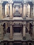 More images
(List of state protected monuments) -
[SL. No.]: S-GJ-234
[Description]: Arjun Chori (Shiva Temple)
[Location]: Kaleshwari
[Address]: Lavana
[District]: Mahisagar
[Coordinates]: 23°19′20″N 73°35′07″E / 23.322187°N 73.585347°E / 23.322187; 73.585347 (SL. No. S-GJ-234)
[Image]:
(List of state protected monuments) -
[SL. No.]: S-GJ-235
[Description]: Kund (Hidimba Kund)
[Location]: Kaleshwari
[Address]: Lavana
[District]: Mahisagar
[Coordinates]: 23°19′16″N 73°34′57″E / 23.321049°N 73.582539°E / 23.321049; 73.582539 (SL. No. S-GJ-235)
[Image]:
(List of state protected monuments) -
[SL. No.]: S-GJ-236
[Description]: Temple with Three Entrances (Hidimba Temple)
[Location]: Kaleshwari
[Address]: Lavana
[District]: Mahisagar
[Coordinates]: 23°19′20″N 73°35′08″E / 23.322295°N 73.585460°E / 23.322295; 73.585460 (SL. No. S-GJ-236)
[Image]:
(List of state protected monuments) -
[SL. No.]: S-GJ-237
[Description]: Ancient Temple (Ghummatvalu Mandir)
[Location]: Kaleshwari
[Address]: Lavana
[District]: Mahisagar
[Coordinates]: 23°19′17″N 73°34′57″E / 23.321372°N 73.582523°E / 23.321372; 73.582523 (SL. No. S-GJ-237)
[Image]:
(List of state protected monuments) -
[SL. No.]: S-GJ-238
[Description]: Bhim Chori (Shiva Temple)
[Location]: Kaleshwari
[Address]: Lavana
[District]: Mahisagar
[Coordinates]: 23°19′18″N 73°35′06″E / 23.321639°N 73.585071°E / 23.321639; 73.585071 (SL. No. S-GJ-238)
[Image]:
(List of state protected monuments) -
[SL. No.]: S-GJ-239
[Description]: Vahu Ni Vav
[Location]: Kaleshwari
[Address]: Lavana
[District]: Mahisagar
[Coordinates]: 23°19′18″N 73°34′55″E / 23.321792°N 73.581871°E / 23.321792; 73.581871 (SL. No. S-GJ-239)
[Image]:
(List of state protected monuments) -
[SL. No.]: S-GJ-240
[Description]: Shikar Madhi
[Location]: Kaleshwari
[Address]: Lavana
[District]: Mahisagar
[Coordinates]: 23°19′17″N 73°34′59″E / 23.321269°N 73.583031°E / 23.321269; 73.583031 (SL. No. S-GJ-240)
[Image]: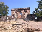
(List of state protected monuments) -
[SL. No.]: S-GJ-241
[Description]: Temple with stone Inscription (Kaleshwari Mata Temple)
[Location]: Kaleshwari
[Address]: Lavana
[District]: Mahisagar
[Coordinates]: 23°19′17″N 73°34′57″E / 23.321500°N 73.582467°E / 23.321500; 73.582467 (SL. No. S-GJ-241)
[Image]:
(List of state protected monuments) -
[SL. No.]: S-GJ-242
[Description]: Sasu Ni Vav
[Location]: Kaleshwari
[Address]: Lavana
[District]: Mahisagar
[Coordinates]: 23°19′16″N 73°34′55″E / 23.321235°N 73.581879°E / 23.321235; 73.581879 (SL. No. S-GJ-242)
[Image]: More images
(List of state protected monuments) -
[SL. No.]: S-GJ-243
[Description]: Ancient temple no.1
[Location]:
[Address]: Santrampur
[District]: Mahisagar
[Coordinates]: 23°11′48″N 73°52′52″E / 23.196803°N 73.881056°E / 23.196803; 73.881056 (SL. No. S-GJ-243)
[Image]:
(List of state protected monuments) -
[SL. No.]: S-GJ-244
[Description]: Ancient temple no.2
[Location]:
[Address]: Santarampur
[District]: Mahisagar
[Coordinates]: 23°11′48″N 73°52′52″E / 23.196803°N 73.881056°E / 23.196803; 73.881056 (SL. No. S-GJ-244)
[Image]:
(List of state protected monuments) -
[SL. No.]: S-GJ-245
[Description]: Ancient temple no.3
[Location]:
[Address]: Santarampur
[District]: Mahisagar
[Coordinates]: 23°11′48″N 73°52′52″E / 23.196803°N 73.881056°E / 23.196803; 73.881056 (SL. No. S-GJ-245)
[Image]:
(List of state protected monuments) -
[SL. No.]: S-GJ-246
[Description]: Gebanshah Vav with Steps
[Location]:
[Address]: Champaner
[District]: Panchmahals
[Coordinates]: 22°28′50″N 73°31′52″E / 22.480445°N 73.53112°E / 22.480445; 73.53112 (SL. No. S-GJ-246)
[Image]:
(List of state protected monuments) -
[SL. No.]: S-GJ-247
[Description]: Vanzari Vav
[Location]:
[Address]: Kankanpur
[District]: Panchmahals
[Coordinates]: 22°49′54″N 73°29′15″E / 22.831746°N 73.48739°E / 22.831746; 73.48739 (SL. No. S-GJ-247)
[Image]:
(List of state protected monuments) -
[SL. No.]: S-GJ-248
[Description]: Group of temples
[Location]: Tuwa
[Address]: Kankanpur
[District]: Panchmahals
[Coordinates]: 22°47′57″N 73°27′37″E / 22.799190°N 73.460411°E / 22.799190; 73.460411 (SL. No. S-GJ-248)
[Image]:
(List of state protected monuments) -
[SL. No.]: S-GJ-249
[Description]: Pavagadh Killa
[Location]:
[Address]: Pavagadh/Chmpaner
[District]: Panchmahals
[Coordinates]:
[Image]:
(List of state protected monuments) -
[SL. No.]: S-GJ-250
[Description]: Machi Killa
[Location]:
[Address]: Pavagadh/Chmpaner
[District]: Panchmahals
[Coordinates]:
[Image]:
(List of state protected monuments) -
[SL. No.]: S-GJ-251
[Description]: Bavaman Killa
[Location]:
[Address]: Pavagadh/Chmpaner
[District]: Panchmahals
[Coordinates]:
[Image]:
(List of state protected monuments) -
[SL. No.]: S-GJ-252
[Description]: Khuneshwar Killa
[Location]:
[Address]: Pavagadh/Chmpaner
[District]: Panchmahals
[Coordinates]:
[Image]:
(List of state protected monuments) -
[SL. No.]: S-GJ-253
[Description]: Killa at Shikar bari and Ulan Julan ki Chowki
[Location]:
[Address]: Pavagadh/Chmpaner
[District]: Panchmahals
[Coordinates]:
[Image]:
(List of state protected monuments) -
[SL. No.]: S-GJ-254
[Description]: Malik Nagar ni Haveli
[Location]:
[Address]: Pavagadh/Chmpaner
[District]: Panchmahals
[Coordinates]:
[Image]:
(List of state protected monuments) -
[SL. No.]: S-GJ-255
[Description]: Gadi Kundal Darwaza
[Location]:
[Address]: Pavagadh/Chmpaner
[District]: Panchmahals
[Coordinates]:
[Image]:
(List of state protected monuments) -
[SL. No.]: S-GJ-256
[Description]: Jai Singh no Mahal
[Location]:
[Address]: Pavagadh/Chmpaner
[District]: Panchmahals
[Coordinates]:
[Image]:
(List of state protected monuments) -
[SL. No.]: S-GJ-257
[Description]: Senapati Ni Kothi
[Location]:
[Address]: Pavagadh/Chmpaner
[District]: Panchmahals
[Coordinates]:
[Image]:
(List of state protected monuments) -
[SL. No.]: S-GJ-258
[Description]: Pavilion on medhi Talav
[Location]:
[Address]: Pavagadh/Chmpaner
[District]: Panchmahals
[Coordinates]:
[Image]:
(List of state protected monuments) -
[SL. No.]: S-GJ-259
[Description]: Masjid in Front of Machi Haveli
[Location]:
[Address]: Pavagadh/Chmpaner
[District]: Panchmahals
[Coordinates]:
[Image]:
(List of state protected monuments) -
[SL. No.]: S-GJ-260
[Description]: Maratha no Mahal
[Location]:
[Address]: Pavagadh/Chmpaner
[District]: Panchmahals
[Coordinates]:
[Image]:
(List of state protected monuments) -
[SL. No.]: S-GJ-261
[Description]: Rani no Mahal
[Location]:
[Address]: Pavagadh/Chmpaner
[District]: Panchmahals
[Coordinates]:
[Image]:
(List of state protected monuments) -
[SL. No.]: S-GJ-262
[Description]: Bandh
[Location]:
[Address]: Pavagadh/Chmpaner
[District]: Panchmahals
[Coordinates]:
[Image]:
(List of state protected monuments) -
[SL. No.]: S-GJ-263
[Description]: Lila Gumbaj Pase ni Kothi
[Location]:
[Address]: Pavagadh/Chmpaner
[District]: Panchmahals
[Coordinates]:
[Image]:
(List of state protected monuments) -
[SL. No.]: S-GJ-264
[Description]: Bhangelu Deru
[Location]:
[Address]: Pavagadh/Chmpaner
[District]: Panchmahals
[Coordinates]:
[Image]:
(List of state protected monuments) -
[SL. No.]: S-GJ-265
[Description]: Chhatris Thambla Nu Bhoyeru
[Location]:
[Address]: Pavagadh/Chmpaner
[District]: Panchmahals
[Coordinates]:
[Image]:
(List of state protected monuments) -
[SL. No.]: S-GJ-266
[Description]: Zare-e-Zamin
[Location]:
[Address]: Pavagadh/Chmpaner
[District]: Panchmahals
[Coordinates]:
[Image]:
(List of state protected monuments) -
[SL. No.]: S-GJ-267
[Description]: Pavilion South of Jami Masjid
[Location]:
[Address]: Pavagadh/Chmpaner
[District]: Panchmahals
[Coordinates]:
[Image]:
(List of state protected monuments) -
[SL. No.]: S-GJ-268
[Description]: Iteri Masjid and Building near to it
[Location]:
[Address]: Pavagadh/Chmpaner
[District]: Panchmahals
[Coordinates]:
[Image]:
(List of state protected monuments) -
[SL. No.]: S-GJ-269
[Description]: Sainiki Masjid
[Location]:
[Address]: Pavagadh/Chmpaner
[District]: Panchmahals
[Coordinates]:
[Image]:
(List of state protected monuments) -
[SL. No.]: S-GJ-270
[Description]: Vandra Masjid
[Location]:
[Address]: Pavagadh/Chmpaner
[District]: Panchmahals
[Coordinates]:
[Image]:
(List of state protected monuments) -
[SL. No.]: S-GJ-271
[Description]: Maqbara Mandvi
[Location]:
[Address]: Pavagadh/Chmpaner
[District]: Panchmahals
[Coordinates]:
[Image]:
(List of state protected monuments) -
[SL. No.]: S-GJ-272
[Description]: Maqbara Near Kamani Masjid
[Location]:
[Address]: Pavagadh/Chmpaner
[District]: Panchmahals
[Coordinates]:
[Image]:
(List of state protected monuments) -
[SL. No.]: S-GJ-273
[Description]: Underground Water Channel From Bandh to Kasbin Talao
[Location]:
[Address]: Pavagadh/Chmpaner
[District]: Panchmahals
[Coordinates]:
[Image]:
(List of state protected monuments) -
[SL. No.]: S-GJ-274
[Description]: Underground Water Channel from Navlakhi Talav to Jamuna Kund
[Location]:
[Address]: Pavagadh/Chmpaner
[District]: Panchmahals
[Coordinates]:
[Image]:
(List of state protected monuments) -
[SL. No.]: S-GJ-275
[Description]: Stone Bridge
[Location]:
[Address]: Pavagadh/Chmpaner
[District]: Panchmahals
[Coordinates]:
[Image]:
(List of state protected monuments) -
[SL. No.]: S-GJ-276
[Description]: Barrack on Sarriya Vakhariya
[Location]:
[Address]: Pavagadh/Chmpaner
[District]: Panchmahals
[Coordinates]:
[Image]:
(List of state protected monuments) -
[SL. No.]: S-GJ-277
[Description]: Malik Sandal Ni Vav
[Location]:
[Address]: Mandvi village (Halol)
[District]: Panchmahals
[Coordinates]: 22°29′38″N 73°30′53″E / 22.493938°N 73.51469°E / 22.493938; 73.51469 (SL. No. S-GJ-277)
[Image]:
(List of state protected monuments) -
[SL. No.]: S-GJ-278
[Description]: Sindh Mata Ni Vav
[Location]:
[Address]: Halol Nagar
[District]: Panchmahals
[Coordinates]: 22°29′50″N 73°29′35″E / 22.497284°N 73.492924°E / 22.497284; 73.492924 (SL. No. S-GJ-278)
[Image]:
(List of state protected monuments) -
[SL. No.]: S-GJ-279
[Description]: Chandralekha (Surajkala) Vav
[Location]:
[Address]: Halol Nagar
[District]: Panchmahals
[Coordinates]: 22°30′14″N 73°27′42″E / 22.50401319°N 73.46162796°E / 22.50401319; 73.46162796 (SL. No. S-GJ-279)
[Image]:
(List of state protected monuments) -
[SL. No.]: S-GJ-280
[Description]: Amther Mata Temple& Small Temples
[Location]:
[Address]: Vadnagar
[District]: Mahesana
[Coordinates]: 23°47′05″N 72°38′43″E / 23.784768°N 72.645252°E / 23.784768; 72.645252 (SL. No. S-GJ-280)
[Image]:
(List of state protected monuments) -
[SL. No.]: S-GJ-281
[Description]: Vav
[Location]:
[Address]: Modhera
[District]: Mahesana
[Coordinates]: 23°35′02″N 72°07′54″E / 23.5839529°N 72.1317516°E / 23.5839529; 72.1317516 (SL. No. S-GJ-281)
[Image]:
(List of state protected monuments) -
[SL. No.]: S-GJ-282
[Description]: Hawa Mahal
[Location]:
[Address]: Modhera
[District]: Patan
[Coordinates]: 23°35′01″N 72°08′07″E / 23.5836998°N 72.1353296°E / 23.5836998; 72.1353296 (SL. No. S-GJ-282)
[Image]: More images
(List of state protected monuments) -
[SL. No.]: S-GJ-283
[Description]: Khan Sarovar
[Location]:
[Address]: Patan
[District]: Patan
[Coordinates]: 23°50′07″N 72°06′48″E / 23.8353096°N 72.1133884°E / 23.8353096; 72.1133884 (SL. No. S-GJ-283)
[Image]:
(List of state protected monuments) -
[SL. No.]: S-GJ-284
[Description]: Shakti Kund
[Location]:
[Address]: Akhaj
[District]: Mahesana
[Coordinates]: 23°29′00″N 72°27′35″E / 23.4834317°N 72.4596435°E / 23.4834317; 72.4596435 (SL. No. S-GJ-284)
[Image]:
(List of state protected monuments) -
[SL. No.]: S-GJ-285
[Description]: Amba Mata Temple
[Location]:
[Address]: Kherva
[District]: Mahesana
[Coordinates]: 23°32′49″N 72°26′28″E / 23.5469433°N 72.4411902°E / 23.5469433; 72.4411902 (SL. No. S-GJ-285)
[Image]:
(List of state protected monuments) -
[SL. No.]: S-GJ-286
[Description]: Shitala Mata Temple
[Location]:
[Address]: Butapaldi
[District]: Mahesana
[Coordinates]: 23°40′10″N 72°21′24″E / 23.669443°N 72.356792°E / 23.669443; 72.356792 (SL. No. S-GJ-286)
[Image]: More images
(List of state protected monuments) -
[SL. No.]: S-GJ-287
[Description]: Nagfani Mata Mandir (with idol)
[Location]:
[Address]: Meu
[District]: Mahesana
[Coordinates]:
[Image]:
(List of state protected monuments) -
[SL. No.]: S-GJ-288
[Description]: Shitala Mata Temple
[Location]:
[Address]: Linch
[District]: Mahesana
[Coordinates]:
[Image]:
(List of state protected monuments) -
[SL. No.]: S-GJ-289
[Description]: Vav
[Location]:
[Address]: Mansa
[District]: Gandhinagar
[Coordinates]: 23°25′24″N 72°39′30″E / 23.4233534°N 72.6582187°E / 23.4233534; 72.6582187 (SL. No. S-GJ-289)
[Image]:
(List of state protected monuments) -
[SL. No.]: S-GJ-290
[Description]: Fatipal Gates
[Location]:
[Address]: Patan
[District]: Patan
[Coordinates]: 23°51′24″N 72°06′48″E / 23.8567087°N 72.1134531°E / 23.8567087; 72.1134531 (SL. No. S-GJ-290)
[Image]:
(List of state protected monuments) -
[SL. No.]: S-GJ-291
[Description]: Chhindia Gates
[Location]:
[Address]: Patan
[District]: Patan
[Coordinates]: 23°51′21″N 72°07′14″E / 23.855969°N 72.120488°E / 23.855969; 72.120488 (SL. No. S-GJ-291)
[Image]:
(List of state protected monuments) -
[SL. No.]: S-GJ-292
[Description]: Bagwada Gates
[Location]:
[Address]: Patan
[District]: Patan
[Coordinates]: 23°51′03″N 72°06′59″E / 23.8507427°N 72.1163716°E / 23.8507427; 72.1163716 (SL. No. S-GJ-292)
[Image]:
(List of state protected monuments) -
[SL. No.]: S-GJ-293
[Description]: Agara Gates
[Location]:
[Address]: Patan
[District]: Patan
[Coordinates]: 23°51′03″N 72°06′59″E / 23.8507427°N 72.1163716°E / 23.8507427; 72.1163716 (SL. No. S-GJ-293)
[Image]:
(List of state protected monuments) -
[SL. No.]: S-GJ-294
[Description]: Tripalia Gate (Tran Darwaja)
[Location]:
[Address]: Patan
[District]: Patan
[Coordinates]: 23°50′50″N 72°06′44″E / 23.8473279°N 72.1123598°E / 23.8473279; 72.1123598 (SL. No. S-GJ-294)
[Image]:
(List of state protected monuments) -
[SL. No.]: S-GJ-295
[Description]: Rajgadhi Timbo
[Location]:
[Address]: Umta
[District]: Mahesana
[Coordinates]: 23°46′51″N 72°33′17″E / 23.780949°N 72.554779°E / 23.780949; 72.554779 (SL. No. S-GJ-295)
[Image]:
(List of state protected monuments) -
[SL. No.]: S-GJ-296
[Description]: Shail Gufao (Khambhalida Caves)
[Location]:
[Address]: Khambhalida
[District]: Rajkot
[Coordinates]: 21°46′31″N 70°42′22″E / 21.775402°N 70.706023°E / 21.775402; 70.706023 (SL. No. S-GJ-296)
[Image]:
(List of state protected monuments) -
[SL. No.]: S-GJ-297
[Description]: Minaldevi Vav
[Location]:
[Address]: Virpur
[District]: Rajkot
[Coordinates]: 21°50′53″N 70°41′47″E / 21.848041°N 70.696446°E / 21.848041; 70.696446 (SL. No. S-GJ-297)
[Image]:
(List of state protected monuments) -
[SL. No.]: S-GJ-298
[Description]: Memorial Stone of Lakha Fulani
[Location]:
[Address]: Atkot
[District]: Rajkot
[Coordinates]:
[Image]:
(List of state protected monuments) -
[SL. No.]: S-GJ-299
[Description]: Stone Inscription
[Location]: In Darbargadh
[Address]: Jasdan
[District]: Rajkot
[Coordinates]: 22°02′17″N 71°12′30″E / 22.038145°N 71.208258°E / 22.038145; 71.208258 (SL. No. S-GJ-299)
[Image]:
(List of state protected monuments) -
[SL. No.]: S-GJ-300
[Description]: Caves
[Location]:
[Address]: Dingthalo Dungar (Jasdan)
[District]: Rajkot
[Coordinates]:
[Image]:
(List of state protected monuments) -
[SL. No.]: S-GJ-301
[Description]: Vav (Gelmata Vav)
[Location]:
[Address]: Bhadla
[District]: Rajkot
[Coordinates]: 22°11′10″N 71°06′07″E / 22.186208°N 71.10201°E / 22.186208; 71.10201 (SL. No. S-GJ-301)
[Image]:
(List of state protected monuments) -
[SL. No.]: S-GJ-302
[Description]: Sankleshwar Mahadev
[Location]:
[Address]: Juni Sankali
[District]: Rajkot
[Coordinates]: 21°41′37″N 70°33′02″E / 21.6936811°N 70.5506477°E / 21.6936811; 70.5506477 (SL. No. S-GJ-302)
[Image]:
(List of state protected monuments) -
[SL. No.]: S-GJ-303
[Description]: Old Darbargadh
[Location]:
[Address]: Dhoraji
[District]: Rajkot
[Coordinates]: 21°44′21″N 70°26′58″E / 21.739153°N 70.449510°E / 21.739153; 70.449510 (SL. No. S-GJ-303)
[Image]:
(List of state protected monuments) -
[SL. No.]: S-GJ-304
[Description]: Temples
[Location]:
[Address]: Supedi
[District]: Rajkot
[Coordinates]: 21°45′52″N 70°22′28″E / 21.7643431°N 70.3744487°E / 21.7643431; 70.3744487 (SL. No. S-GJ-304)
[Image]:
(List of state protected monuments) -
[SL. No.]: S-GJ-305
[Description]: Kuber Vav
[Location]:
[Address]: Morbi
[District]: Morbi
[Coordinates]: 22°49′05″N 70°50′09″E / 22.818020°N 70.835818°E / 22.818020; 70.835818 (SL. No. S-GJ-305)
[Image]:
(List of state protected monuments) -
[SL. No.]: S-GJ-306
[Description]: Darbargadh No Tamrapatro
[Location]:
[Address]: Morbi
[District]: Morbi
[Coordinates]: 22°49′04″N 70°50′25″E / 22.8177113°N 70.8402245°E / 22.8177113; 70.8402245 (SL. No. S-GJ-306)
[Image]:
(List of state protected monuments) -
[SL. No.]: S-GJ-307
[Description]: Mound Dolidhar
[Location]:
[Address]: Khorana
[District]: Rajkot
[Coordinates]: 22°25′39″N 70°50′57″E / 22.427573°N 70.849066°E / 22.427573; 70.849066 (SL. No. S-GJ-307)
[Image]:
(List of state protected monuments) -
[SL. No.]: S-GJ-308
[Description]: Stone Inscription at Jadeshwar Mahadev
[Location]:
[Address]: Wankaner
[District]: Morbi
[Coordinates]: 22°38′44″N 70°51′16″E / 22.6455809°N 70.8544328°E / 22.6455809; 70.8544328 (SL. No. S-GJ-308)
[Image]:
(List of state protected monuments) -
[SL. No.]: S-GJ-309
[Description]: Ancient Vav
[Location]:
[Address]: Sarvad
[District]: Morbi
[Coordinates]: 22°58′56″N 70°42′07″E / 22.982234°N 70.701972°E / 22.982234; 70.701972 (SL. No. S-GJ-309)
[Image]:
(List of state protected monuments) -
[SL. No.]: S-GJ-310
[Description]: Jam Tower
[Location]:
[Address]: Rajkot
[District]: Rajkot
[Coordinates]: 22°18′23″N 70°47′50″E / 22.3062972°N 70.7971058°E / 22.3062972; 70.7971058 (SL. No. S-GJ-310)
[Image]: More images
(List of state protected monuments) -
[SL. No.]: S-GJ-311
[Description]: Ancient Talav
[Location]:
[Address]: Tentalav
[District]: Vadodara
[Coordinates]: 22°02′46″N 73°25′26″E / 22.046077°N 73.423821°E / 22.046077; 73.423821 (SL. No. S-GJ-311)
[Image]:
(List of state protected monuments) -
[SL. No.]: S-GJ-312
[Description]: Vidyadhar Vav
[Location]:
[Address]: Sevasi
[District]: Vadodara
[Coordinates]: 22°19′06″N 73°07′00″E / 22.3182137°N 73.1166384°E / 22.3182137; 73.1166384 (SL. No. S-GJ-312)
[Image]: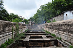 More images
(List of state protected monuments) -
[SL. No.]: S-GJ-313
[Description]: Surya Narayan Temple
[Location]:
[Address]: Vadodara
[District]: Vadodara
[Coordinates]: 22°18′12″N 73°11′18″E / 22.3034682°N 73.1882022°E / 22.3034682; 73.1882022 (SL. No. S-GJ-313)
[Image]: More images
(List of state protected monuments) -
[SL. No.]: S-GJ-314
[Description]: Ranmukteshwar Temple
[Location]:
[Address]: Mankani (Sankheda)
[District]: Chhota Udaipur district
[Coordinates]: 22°13′33″N 73°40′21″E / 22.225863°N 73.672610°E / 22.225863; 73.672610 (SL. No. S-GJ-314)
[Image]:
(List of state protected monuments) -
[SL. No.]: S-GJ-315
[Description]: Kund
[Location]: Gambhirpura
[Address]: Idar
[District]: Sabarkantha
[Coordinates]: 23°51′00″N 73°00′53″E / 23.850043°N 73.014690°E / 23.850043; 73.014690 (SL. No. S-GJ-315)
[Image]:
(List of state protected monuments) -
[SL. No.]: S-GJ-316
[Description]: Vav
[Location]: Gambhirpura
[Address]: Idar
[District]: Sabarkantha
[Coordinates]: 23°50′57″N 73°00′47″E / 23.849172°N 73.013033°E / 23.849172; 73.013033 (SL. No. S-GJ-316)
[Image]:
(List of state protected monuments) -
[SL. No.]: S-GJ-317
[Description]: Ranmalchoki
[Location]: Idariyogadh
[Address]: Idar
[District]: Sabarkantha
[Coordinates]: 23°51′09″N 73°00′02″E / 23.852540°N 73.000692°E / 23.852540; 73.000692 (SL. No. S-GJ-317)
[Image]:
(List of state protected monuments) -
[SL. No.]: S-GJ-318
[Description]: Vav
[Location]:
[Address]: Chorivad
[District]: Sabarkantha
[Coordinates]: 23°54′00″N 73°07′33″E / 23.900018°N 73.125705°E / 23.900018; 73.125705 (SL. No. S-GJ-318)
[Image]:
(List of state protected monuments) -
[SL. No.]: S-GJ-320
[Description]: Ancient Temple
[Location]:
[Address]: Davad
[District]: Sabarkantha
[Coordinates]:
[Image]:
(List of state protected monuments) -
[SL. No.]: S-GJ-321
[Description]: Ancient stepwell (vav)
[Location]:
[Address]: Limbhoi
[District]: Sabarkantha
[Coordinates]: 23°51′57″N 72°59′11″E / 23.865784°N 72.986352°E / 23.865784; 72.986352 (SL. No. S-GJ-321)
[Image]:
(List of state protected monuments) -
[SL. No.]: S-GJ-322
[Description]: Kund
[Location]:
[Address]: Sabli
[District]: Sabarkantha
[Coordinates]: 23°43′56″N 73°03′28″E / 23.732156°N 73.057811°E / 23.732156; 73.057811 (SL. No. S-GJ-322)
[Image]:
(List of state protected monuments) -
[SL. No.]: S-GJ-323
[Description]: Ancient Temple
[Location]:
[Address]: Davad
[District]: Sabarkantha
[Coordinates]:
[Image]:
(List of state protected monuments) -
[SL. No.]: S-GJ-324
[Description]: Mahadev Temple
[Location]:
[Address]: Agiya
[District]: Sabarkantha
[Coordinates]:
[Image]:
(List of state protected monuments) -
[SL. No.]: S-GJ-325
[Description]: Shiva Temple
[Location]: Near Ganchhali
[Address]: Kajavas
[District]: Sabarkantha
[Coordinates]:
[Image]:
(List of state protected monuments) -
[SL. No.]: S-GJ-326
[Description]: Brahma Vav
[Location]:
[Address]: Khedbrahma
[District]: Sabarkantha
[Coordinates]: 24°02′19″N 73°02′53″E / 24.0384898°N 73.0480673°E / 24.0384898; 73.0480673 (SL. No. S-GJ-326)
[Image]:
(List of state protected monuments) -
[SL. No.]: S-GJ-327
[Description]: Temple No. 1
[Location]:
[Address]: Ganchhali
[District]: Sabarkantha
[Coordinates]:
[Image]:
(List of state protected monuments) -
[SL. No.]: S-GJ-328
[Description]: Temple No. 2
[Location]:
[Address]: Ganchhali
[District]: Sabarkantha
[Coordinates]:
[Image]:
(List of state protected monuments) -
[SL. No.]: S-GJ-329
[Description]: Temple No. 3
[Location]:
[Address]: Ganchhali
[District]: Sabarkantha
[Coordinates]:
[Image]:
(List of state protected monuments) -
[SL. No.]: S-GJ-330
[Description]: Temple No. 4
[Location]:
[Address]: Ganchhali
[District]: Sabarkantha
[Coordinates]:
[Image]:
(List of state protected monuments) -
[SL. No.]: S-GJ-331
[Description]: Temple No. 5
[Location]:
[Address]: Ganchhali
[District]: Sabarkantha
[Coordinates]:
[Image]:
(List of state protected monuments) -
[SL. No.]: S-GJ-332
[Description]: Gopnath Mahadev Shiv Panchayatan Temple
[Location]:
[Address]: Gota (Khedbrahma)
[District]: Sabarkantha
[Coordinates]: 23°59′40″N 73°03′50″E / 23.9944874°N 73.0637892°E / 23.9944874; 73.0637892 (SL. No. S-GJ-332)
[Image]:
(List of state protected monuments) -
[SL. No.]: S-GJ-333
[Description]: Shiva Temple
[Location]: Dantral?
[Address]: Detran
[District]: Sabarkantha
[Coordinates]:
[Image]:
(List of state protected monuments) -
[SL. No.]: S-GJ-334
[Description]: Nilkanth Mahadev Temple
[Location]:
[Address]: Poshina
[District]: Sabarkantha
[Coordinates]:
[Image]:
(List of state protected monuments) -
[SL. No.]: S-GJ-335
[Description]: Ruins
[Location]:
[Address]: Nandej
[District]: Aravalli
[Coordinates]:
[Image]:
(List of state protected monuments) -
[SL. No.]: S-GJ-336
[Description]: Mahakali Temple
[Location]:
[Address]: Nandej
[District]: Aravalli
[Coordinates]:
[Image]:
(List of state protected monuments) -
[SL. No.]: S-GJ-337
[Description]: Mahadev Temple
[Location]:
[Address]: Nandej
[District]: Aravalli
[Coordinates]:
[Image]:
(List of state protected monuments) -
[SL. No.]: S-GJ-338
[Description]: Hanumanji Temple
[Location]:
[Address]: Nandej
[District]: Aravalli
[Coordinates]:
[Image]:
(List of state protected monuments) -
[SL. No.]: S-GJ-339
[Description]: Shiva Panchayatan Temple
[Location]:
[Address]: Bhetali
[District]: Aravalli
[Coordinates]: 23°43′40″N 73°17′37″E / 23.7277292°N 73.2937061°E / 23.7277292; 73.2937061 (SL. No. S-GJ-339)
[Image]:
(List of state protected monuments) -
[SL. No.]: S-GJ-340
[Description]: Shobhayada Shiva Temple
[Location]:
[Address]: Moti Bebar
[District]: Aravalli
[Coordinates]: 23°39′05″N 73°15′36″E / 23.651268°N 73.259958°E / 23.651268; 73.259958 (SL. No. S-GJ-340)
[Image]:
(List of state protected monuments) -
[SL. No.]: S-GJ-341
[Description]: Ancient Temple
[Location]:
[Address]: Shamlaji
[District]: Aravalli
[Coordinates]: 23°41′14″N 73°23′22″E / 23.6871682°N 73.3895109°E / 23.6871682; 73.3895109 (SL. No. S-GJ-341)
[Image]:
(List of state protected monuments) -
[SL. No.]: S-GJ-342
[Description]: Vav
[Location]:
[Address]: Shamlaji
[District]: Aravalli
[Coordinates]: 23°41′16″N 73°23′15″E / 23.687886°N 73.387506°E / 23.687886; 73.387506 (SL. No. S-GJ-342)
[Image]:
(List of state protected monuments) -
[SL. No.]: S-GJ-343
[Description]: Harishchandra ni Chori
[Location]:
[Address]: Shamlaji
[District]: Aravalli
[Coordinates]: 23°41′10″N 73°23′03″E / 23.686083°N 73.384260°E / 23.686083; 73.384260 (SL. No. S-GJ-343)
[Image]:
(List of state protected monuments) -
[SL. No.]: S-GJ-344
[Description]: Pagathiyavali Vav (Stepwell)
[Location]:
[Address]: Tintoi
[District]: Aravalli
[Coordinates]: 23°36′50″N 73°19′56″E / 23.6140038°N 73.33234707°E / 23.6140038; 73.33234707 (SL. No. S-GJ-344)
[Image]:
(List of state protected monuments) -
[SL. No.]: S-GJ-345
[Description]: Vanzari Vav
[Location]:
[Address]: Modasa
[District]: Aravalli
[Coordinates]: 23°28′02″N 73°17′40″E / 23.467186°N 73.294424°E / 23.467186; 73.294424 (SL. No. S-GJ-345)
[Image]:
(List of state protected monuments) -
[SL. No.]: S-GJ-346
[Description]: Temple with Kund
[Location]:
[Address]: Abhapur
[District]: Sabarkantha
[Coordinates]: 24°00′04″N 73°16′54″E / 24.001077°N 73.281589°E / 24.001077; 73.281589 (SL. No. S-GJ-346)
[Image]:
(List of state protected monuments) -
[SL. No.]: S-GJ-347
[Description]: Jain Temple No. 1
[Location]:
[Address]: Abhapur
[District]: Sabarkantha
[Coordinates]: 24°00′01″N 73°16′49″E / 24.0003324°N 73.2804055°E / 24.0003324; 73.2804055 (SL. No. S-GJ-347)
[Image]:
(List of state protected monuments) -
[SL. No.]: S-GJ-348
[Description]: Jain Temple No. 2
[Location]:
[Address]: Abhapur
[District]: Sabarkantha
[Coordinates]: 24°00′01″N 73°16′49″E / 24.0003324°N 73.2804055°E / 24.0003324; 73.2804055 (SL. No. S-GJ-348)
[Image]:
(List of state protected monuments) -
[SL. No.]: S-GJ-349
[Description]: Jain Temple No. 3
[Location]:
[Address]: Abhapur
[District]: Sabarkantha
[Coordinates]: 24°00′07″N 73°16′56″E / 24.001998°N 73.282265°E / 24.001998; 73.282265 (SL. No. S-GJ-349)
[Image]:
(List of state protected monuments) -
[SL. No.]: S-GJ-350
[Description]: Sharaneshwar Temple
[Location]:
[Address]: Abhapur
[District]: Sabarkantha
[Coordinates]: 24°00′05″N 73°16′08″E / 24.0014816°N 73.2688724°E / 24.0014816; 73.2688724 (SL. No. S-GJ-350)
[Image]:
(List of state protected monuments) -
[SL. No.]: S-GJ-351
[Description]: Shivashakti Temple
[Location]:
[Address]: Abhapur
[District]: Sabarkantha
[Coordinates]: 23°59′58″N 73°16′29″E / 23.999452°N 73.2746777°E / 23.999452; 73.2746777 (SL. No. S-GJ-351)
[Image]:
(List of state protected monuments) -
[SL. No.]: S-GJ-352
[Description]: Jain Temple No. 1
[Location]:
[Address]: Antarsumba
[District]: Sabarkantha
[Coordinates]: 23°59′18″N 73°13′11″E / 23.9883575°N 73.2196152°E / 23.9883575; 73.2196152 (SL. No. S-GJ-352)
[Image]:
(List of state protected monuments) -
[SL. No.]: S-GJ-353
[Description]: Jain Temple No. 2
[Location]:
[Address]: Antarsumba
[District]: Sabarkantha
[Coordinates]: 23°59′18″N 73°13′11″E / 23.9883575°N 73.2196151°E / 23.9883575; 73.2196151 (SL. No. S-GJ-353)
[Image]:
(List of state protected monuments) -
[SL. No.]: S-GJ-354
[Description]: Jain Temple No. 3
[Location]:
[Address]: Antarsumba
[District]: Sabarkantha
[Coordinates]: 23°59′18″N 73°13′09″E / 23.988307°N 73.219176°E / 23.988307; 73.219176 (SL. No. S-GJ-354)
[Image]:
(List of state protected monuments) -
[SL. No.]: S-GJ-355
[Description]: Jain Temple No. 4
[Location]:
[Address]: Antarsumba
[District]: Sabarkantha
[Coordinates]: 23°59′17″N 73°13′08″E / 23.988049°N 73.21891°E / 23.988049; 73.21891 (SL. No. S-GJ-355)
[Image]:
(List of state protected monuments) -
[SL. No.]: S-GJ-356
[Description]: Shakti Temple
[Location]:
[Address]: Antarsumba
[District]: Sabarkantha
[Coordinates]: 23°59′05″N 73°12′35″E / 23.9846695°N 73.2098568°E / 23.9846695; 73.2098568 (SL. No. S-GJ-356)
[Image]:
(List of state protected monuments) -
[SL. No.]: S-GJ-357
[Description]: Shiva Temple
[Location]:
[Address]: Antarsumba
[District]: Sabarkantha
[Coordinates]: 23°59′05″N 73°12′35″E / 23.9846695°N 73.2098568°E / 23.9846695; 73.2098568 (SL. No. S-GJ-357)
[Image]:
(List of state protected monuments) -
[SL. No.]: S-GJ-358
[Description]: Shiva Panchayatan Temple No. 1
[Location]:
[Address]: Antarsumba
[District]: Sabarkantha
[Coordinates]:
[Image]:
(List of state protected monuments) -
[SL. No.]: S-GJ-359
[Description]: Shiva Panchayatan Temple No. 2
[Location]:
[Address]: Antarsumba
[District]: Sabarkantha
[Coordinates]: 23°59′18″N 73°13′09″E / 23.9882347°N 73.2191991°E / 23.9882347; 73.2191991 (SL. No. S-GJ-359)
[Image]:
(List of state protected monuments) -
[SL. No.]: S-GJ-360
[Description]: Vav (Stepwell)
[Location]:
[Address]: Dholi Vav (Vijaynagar)
[District]: Sabarkantha
[Coordinates]:
[Image]:
(List of state protected monuments) -
[SL. No.]: S-GJ-361
[Description]: Nagrani Vav (Stepwell) (Roda Group of Temples)
[Location]:
[Address]: Khed-Chandarani
[District]: Sabarkantha
[Coordinates]: 23°39′51″N 73°05′47″E / 23.664303°N 73.096359°E / 23.664303; 73.096359 (SL. No. S-GJ-361)
[Image]:
(List of state protected monuments) -
[SL. No.]: S-GJ-362
[Description]: Santhaleshwar Mahadev Temple
[Location]:
[Address]: Mathasuliya
[District]: Sabarkantha
[Coordinates]:
[Image]:
(List of state protected monuments) -
[SL. No.]: S-GJ-363
[Description]: Chaumukh Mahadev Temple
[Location]:
[Address]: Hathrol
[District]: Sabarkantha
[Coordinates]: 23°30′46″N 73°07′31″E / 23.512781°N 73.125374°E / 23.512781; 73.125374 (SL. No. S-GJ-363)
[Image]:
(List of state protected monuments) -
[SL. No.]: S-GJ-364
[Description]: Neminath Jain Temple with three inscriptions dated Samvat 1333, 35, 39 on pillar (Girnar Jain temples)
[Location]: On Girnar Hill
[Address]: Junagadh
[District]: Junagadh
[Coordinates]: 21°31′38″N 70°31′23″E / 21.527259°N 70.5231704°E / 21.527259; 70.5231704 (SL. No. S-GJ-364)
[Image]: More images
(List of state protected monuments) -
[SL. No.]: S-GJ-365
[Description]: Vastupal Jain Temple with six inscriptions dated Samvat 1288 on pillar (Girnar Jain temples)
[Location]: On Girnar Hill
[Address]: Junagadh
[District]: Junagadh
[Coordinates]: 21°31′36″N 70°31′24″E / 21.5267561°N 70.5233514°E / 21.5267561; 70.5233514 (SL. No. S-GJ-365)
[Image]: More images
(List of state protected monuments) -
[SL. No.]: S-GJ-366
[Description]: Virji Vora ni Vav
[Location]: Halvad
[Address]: Morbi
[District]: Surendranagar
[Coordinates]: 23°00′50″N 71°10′57″E / 23.01401612°N 71.18256532°E / 23.01401612; 71.18256532 (SL. No. S-GJ-366)
[Image]:
(List of state protected monuments)
New Random Display Display All Items(364)