


-
[ID]: ES0000001
[Name]: Cíes Islands(official name: Illas Cíes)Other names: n/a
[Coordinates]: 42°13′00″N 8°54′16″W / 42.2167°N 8.9044°W / 42.2167; -8.9044 (Illas Cíes)
[Image]: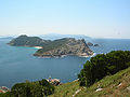
-
[ID]: ES1110001
[Name]: Ortigueira - Mera(official name: Ortigueira - Mera)Other names: n/a
[Coordinates]: 43°42′11″N 7°50′07″W / 43.7031°N 7.8352°W / 43.7031; -7.8352 (Ortigueira - Mera)
[Image]:
-
[ID]: ES1110002
[Name]: Costa Ártabra(official name: Costa Ártabra)Other names: n/a
[Coordinates]: 43°43′05″N 7°57′17″W / 43.7181°N 7.9548°W / 43.7181; -7.9548 (Costa Ártabra)
[Image]: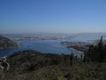
-
[ID]: ES1110003
[Name]: Fragas do Eume(official name: Fragas do Eume)Other names: n/a
[Coordinates]: 43°22′52″N 7°59′36″W / 43.3812°N 7.9934°W / 43.3812; -7.9934 (Fragas do Eume)
[Image]: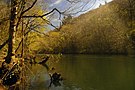
-
[ID]: ES1110004
[Name]: Encoro de Abegondo - Cecebre(official name: Encoro de Abegondo - Cecebre)Other names: n/a
[Coordinates]: 43°16′17″N 8°15′46″W / 43.2715°N 8.2628°W / 43.2715; -8.2628 (Encoro de Abegondo - Cecebre)
[Image]:
-
[ID]: ES1110005
[Name]: Costa da Morte(official name: Costa da Morte)Other names: n/a
[Coordinates]: 42°52′06″N 9°14′41″W / 42.8683°N 9.2448°W / 42.8683; -9.2448 (Costa da Morte)
[Image]: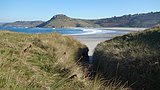
-
[ID]: ES1110006
[Name]: The Dunes of Corrubedo Natural Park(official name: Complexo húmido de Corrubedo)Other names: n/a
[Coordinates]: 42°31′50″N 9°05′25″W / 42.5306°N 9.0903°W / 42.5306; -9.0903 (Complexo húmido de Corrubedo)
[Image]:
-
[ID]: ES1110007
[Name]: Betanzos - Mandeo(official name: Betanzos - Mandeo)Other names: n/a
[Coordinates]: 43°15′07″N 8°07′02″W / 43.2519°N 8.1173°W / 43.2519; -8.1173 (Betanzos - Mandeo)
[Image]:
-
[ID]: ES1110008
[Name]: Carnota - Monte Pindo(official name: Carnota - Monte Pindo)Other names: n/a
[Coordinates]: 42°53′25″N 9°07′08″W / 42.8902°N 9.1189°W / 42.8902; -9.1189 (Carnota - Monte Pindo)
[Image]: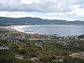
-
[ID]: ES1110009
[Name]: Costa de Dexo(official name: Costa de Dexo)Other names: n/a
[Coordinates]: 43°23′57″N 8°19′39″W / 43.3991°N 8.3275°W / 43.3991; -8.3275 (Costa de Dexo)
[Image]:
-
[ID]: ES1110010
[Name]: Punta de Estaca de Bares(official name: Estaca de Bares)Other names: n/a
[Coordinates]: 43°46′06″N 7°41′48″W / 43.7683°N 7.6967°W / 43.7683; -7.6967 (Estaca de Bares)
[Image]:
-
[ID]: ES1110011
[Name]: Esteiro do Tambre(official name: Esteiro do Tambre)Other names: n/a
[Coordinates]: 42°48′28″N 8°54′07″W / 42.8078°N 8.9019°W / 42.8078; -8.9019 (Esteiro do Tambre)
[Image]: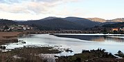
-
[ID]: ES1110012
[Name]: Monte e lagoa de Louro(official name: Monte e lagoa de Louro)Other names: n/a
[Coordinates]: 42°45′39″N 9°06′54″W / 42.7609°N 9.1149°W / 42.7609; -9.1149 (Monte e lagoa de Louro)
[Image]: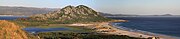
-
[ID]: ES1110013
[Name]: Xubia - Castro(official name: Xubia - Castro)Other names: n/a
[Coordinates]: 43°28′47″N 8°01′27″W / 43.4797°N 8.0241°W / 43.4797; -8.0241 (Xubia - Castro)
[Image]: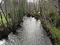
-
[ID]: ES1110014
[Name]: Serra do Careón(official name: Serra do Careón)Other names: n/a
[Coordinates]: 42°55′17″N 7°57′20″W / 42.9214°N 7.9556°W / 42.9214; -7.9556 (Serra do Careón)
[Image]:
-
[ID]: ES1110015
[Name]: Anllóns(official name: Río Anllóns)Other names: n/a
[Coordinates]: 43°13′55″N 8°50′14″W / 43.2319°N 8.8371°W / 43.2319; -8.8371 (Río Anllóns)
[Image]: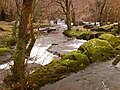
-
[ID]: ES1110016
[Name]: Tambre (river)(official name: Río Tambre)Other names: n/a
[Coordinates]: 42°57′47″N 8°26′24″W / 42.963°N 8.4401°W / 42.963; -8.4401 (Río Tambre)
[Image]:
-
[ID]: ES1120001
[Name]: Ancares - Courel(official name: Ancares - Courel)Other names: n/a
[Coordinates]: 42°52′33″N 6°57′57″W / 42.8758°N 6.9657°W / 42.8758; -6.9657 (Ancares - Courel)
[Image]: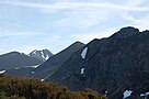
-
[ID]: ES1120002
[Name]: Eo (river)(official name: Río Eo)Other names: n/a
[Coordinates]: 43°31′15″N 7°02′44″W / 43.5208°N 7.0455°W / 43.5208; -7.0455 (Río Eo)
[Image]: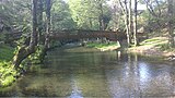
-
[ID]: ES1120003
[Name]: Parga - Ladra - Támoga(official name: Parga - Ladra - Támoga)Other names: n/a
[Coordinates]: 43°09′53″N 7°34′08″W / 43.1648°N 7.5689°W / 43.1648; -7.5689 (Parga - Ladra - Támoga)
[Image]:
-
[ID]: ES1120004
[Name]: A Marronda(official name: A Marronda)Other names: n/a
[Coordinates]: 43°06′09″N 7°12′57″W / 43.1024°N 7.2157°W / 43.1024; -7.2157 (A Marronda)
[Image]: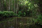
-
[ID]: ES1120005
[Name]: As Catedrais beach(official name: As Catedrais)Other names: n/a
[Coordinates]: 43°33′11″N 7°07′21″W / 43.5531°N 7.1226°W / 43.5531; -7.1226 (As Catedrais)
[Image]:
-
[ID]: ES1120006
[Name]: Carballido(official name: Carballido)Other names: n/a
[Coordinates]: 43°17′08″N 7°09′08″W / 43.2856°N 7.1523°W / 43.2856; -7.1523 (Carballido)
[Image]:
-
[ID]: ES1120007
[Name]: Cruzul - Agüeira(official name: Cruzul - Agüeira)Other names: n/a
[Coordinates]: 42°50′48″N 7°09′15″W / 42.8467°N 7.1542°W / 42.8467; -7.1542 (Cruzul - Agüeira)
[Image]:
-
[ID]: ES1120008
[Name]: Monte Faro(official name: Monte Faro)Other names: n/a
[Coordinates]: 42°37′44″N 7°53′26″W / 42.6288°N 7.8906°W / 42.6288; -7.8906 (Monte Faro)
[Image]:
-
[ID]: ES1120009
[Name]: Monte Maior(official name: Monte Maior)Other names: n/a
[Coordinates]: 43°38′29″N 7°32′11″W / 43.6415°N 7.5364°W / 43.6415; -7.5364 (Monte Maior)
[Image]:
-
[ID]: ES1120010
[Name]: Negueira(official name: Negueira)Other names: n/a
[Coordinates]: 43°08′08″N 6°52′09″W / 43.1355°N 6.8693°W / 43.1355; -6.8693 (Negueira)
[Image]:
-
[ID]: ES1120011
[Name]: Ría de Foz - Masma(official name: Ría de Foz - Masma)Other names: n/a
[Coordinates]: 43°32′54″N 7°15′37″W / 43.5483°N 7.2604°W / 43.5483; -7.2604 (Ría de Foz - Masma)
[Image]:
-
[ID]: ES1120012
[Name]: Río Landro(official name: Río Landro)Other names: n/a
[Coordinates]: 43°37′43″N 7°37′03″W / 43.6287°N 7.6175°W / 43.6287; -7.6175 (Río Landro)
[Image]:
-
[ID]: ES1120013
[Name]: Río Ouro(official name: Río Ouro)Other names: n/a
[Coordinates]: 43°31′54″N 7°25′18″W / 43.5318°N 7.4217°W / 43.5318; -7.4217 (Río Ouro)
[Image]:
-
[ID]: ES1120014
[Name]: Sil Canyon(official name: Canón do Sil)Other names: n/a
[Coordinates]: 42°25′11″N 7°37′45″W / 42.4198°N 7.6292°W / 42.4198; -7.6292 (Canón do Sil)
[Image]:
-
[ID]: ES1120015
[Name]: Serra do Xistral(official name: Serra do Xistral)Other names: n/a
[Coordinates]: 43°27′23″N 7°34′36″W / 43.4564°N 7.5767°W / 43.4564; -7.5767 (Serra do Xistral)
[Image]:
-
[ID]: ES1120016
[Name]: Río Cabe(official name: Río Cabe)Other names: n/a
[Coordinates]: 42°38′39″N 7°24′02″W / 42.6441°N 7.4006°W / 42.6441; -7.4006 (Río Cabe)
[Image]:
-
[ID]: ES1120017
[Name]: Costa da Mariña occidental(official name: Costa da Mariña occidental)Other names: n/a
[Coordinates]: 43°43′25″N 7°37′47″W / 43.7237°N 7.6297°W / 43.7237; -7.6297 (Costa da Mariña occidental)
[Image]:
-
[ID]: ES1130001
[Name]: Baixa Limia – Serra do Xurés(official name: Baixa Limia)Other names: n/a
[Coordinates]: 41°54′01″N 7°59′08″W / 41.9004°N 7.9855°W / 41.9004; -7.9855 (Baixa Limia)
[Image]:
-
[ID]: ES1130002
[Name]: Macizo Central(official name: Macizo Central)Other names: n/a
[Coordinates]: 42°13′03″N 7°17′09″W / 42.2175°N 7.2858°W / 42.2175; -7.2858 (Macizo Central)
[Image]:
-
[ID]: ES1130003
[Name]: Bidueiral de Montederramo(official name: Bidueiral de Montederramo)Other names: n/a
[Coordinates]: 42°13′22″N 7°29′28″W / 42.2229°N 7.4912°W / 42.2229; -7.4912 (Bidueiral de Montederramo)
[Image]: -
[ID]: ES1130004
[Name]: Pena Veidosa(official name: Pena Veidosa)Other names: n/a
[Coordinates]: 42°31′43″N 7°55′49″W / 42.5286°N 7.9303°W / 42.5286; -7.9303 (Pena Veidosa)
[Image]:
-
[ID]: ES1130005
[Name]: Tâmega (river)(official name: Río Támega)Other names: n/a
[Coordinates]: 41°55′25″N 7°24′54″W / 41.9235°N 7.4149°W / 41.9235; -7.4149 (Río Támega)
[Image]: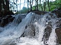
-
[ID]: ES1130006
[Name]: Veiga de Ponteliñares(official name: Veiga de Ponteliñares)Other names: n/a
[Coordinates]: 42°02′32″N 7°51′01″W / 42.0423°N 7.8504°W / 42.0423; -7.8504 (Veiga de Ponteliñares)
[Image]: -
[ID]: ES1130007
[Name]: Trevinca(official name: Pena Trevinca)Other names: n/a
[Coordinates]: 42°15′03″N 6°51′25″W / 42.2507°N 6.857°W / 42.2507; -6.857 (Pena Trevinca)
[Image]:
-
[ID]: ES1130008
[Name]: Pena Maseira(official name: Pena Maseira)Other names: n/a
[Coordinates]: 41°59′00″N 7°00′48″W / 41.9833°N 7.0134°W / 41.9833; -7.0134 (Pena Maseira)
[Image]: -
[ID]: ES1130009
[Name]: Serra da Enciña da Lastra(official name: Serra da Enciña da Lastra)Other names: n/a
[Coordinates]: 42°28′38″N 6°50′20″W / 42.4773°N 6.8389°W / 42.4773; -6.8389 (Serra da Enciña da Lastra)
[Image]: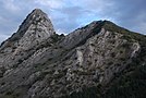
-
[ID]: ES1140001
[Name]: Sistema fluvial Ulla - Deza(official name: Sistema fluvial Ulla - Deza)Other names: n/a
[Coordinates]: 42°45′25″N 8°29′45″W / 42.7569°N 8.4957°W / 42.7569; -8.4957 (Sistema fluvial Ulla - Deza)
[Image]:
-
[ID]: ES1140002
[Name]: Lérez(official name: Río Lérez)Other names: n/a
[Coordinates]: 42°27′07″N 8°36′14″W / 42.4519°N 8.604°W / 42.4519; -8.604 (Río Lérez)
[Image]:
-
[ID]: ES1140003
[Name]: A Ramallosa(official name: A Ramallosa)Other names: n/a
[Coordinates]: 42°07′04″N 8°49′09″W / 42.1177°N 8.8191°W / 42.1177; -8.8191 (A Ramallosa)
[Image]: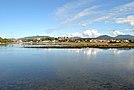
-
[ID]: ES1140004
[Name]: Atlantic Islands of Galicia National Park(official name: Complexo Ons - O Grove)Other names: n/a
[Coordinates]: 42°22′55″N 8°54′36″W / 42.382°N 8.9099°W / 42.382; -8.9099 (Complexo Ons - O Grove)
[Image]:
-
[ID]: ES1140005
[Name]: Monte Aloia(official name: Monte Aloia)Other names: n/a
[Coordinates]: 42°04′56″N 8°40′48″W / 42.0822°N 8.68°W / 42.0822; -8.68 (Monte Aloia)
[Image]: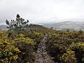
-
[ID]: ES1140006
[Name]: Río Tea(official name: Río Tea)Other names: n/a
[Coordinates]: 42°12′43″N 8°26′14″W / 42.212°N 8.4373°W / 42.212; -8.4373 (Río Tea)
[Image]:
-
[ID]: ES1140007
[Name]: O Baixo Miño(official name: Baixo Miño)Other names: n/a
[Coordinates]: 42°58′58″N 8°42′35″W / 42.9829°N 8.7096°W / 42.9829; -8.7096 (Baixo Miño)
[Image]: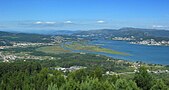
-
[ID]: ES1140008
[Name]: Brañas de Xestoso(official name: Brañas de Xestoso)Other names: n/a
[Coordinates]: 42°40′42″N 8°19′43″W / 42.6784°N 8.3286°W / 42.6784; -8.3286 (Brañas de Xestoso)
[Image]: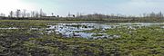
-
[ID]: ES1140009
[Name]: Cabo Udra(official name: Cabo Udra)Other names: n/a
[Coordinates]: 42°19′26″N 8°49′42″W / 42.324°N 8.8284°W / 42.324; -8.8284 (Cabo Udra)
[Image]: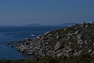
-
[ID]: ES1140010
[Name]: Costa da Vela(official name: Costa da Vela)Other names: n/a
[Coordinates]: 42°16′38″N 8°52′05″W / 42.2773°N 8.868°W / 42.2773; -8.868 (Costa da Vela)
[Image]:
-
[ID]: ES1140011
[Name]: Gándaras de Budiño(official name: Gándaras de Budiño)Other names: n/a
[Coordinates]: 42°03′44″N 8°37′45″W / 42.0622°N 8.6291°W / 42.0622; -8.6291 (Gándaras de Budiño)
[Image]: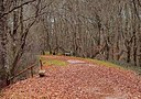
-
[ID]: ES1140012
[Name]: Illas Estelas(official name: Illas Estelas)Other names: n/a
[Coordinates]: 42°09′00″N 8°51′35″W / 42.15°N 8.8597°W / 42.15; -8.8597 (Illas Estelas)
[Image]: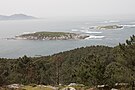
-
[ID]: ES1140013
[Name]: Serra do Candán(official name: Serra do Candán)Other names: n/a
[Coordinates]: 42°34′17″N 8°14′35″W / 42.5715°N 8.243°W / 42.5715; -8.243 (Serra do Candán)
[Image]:
-
[ID]: ES1140014
[Name]: Serra do Cando(official name: Serra do Cando)Other names: n/a
[Coordinates]: 42°27′58″N 8°23′19″W / 42.466°N 8.3887°W / 42.466; -8.3887 (Serra do Cando)
[Image]: -
[ID]: ES1140015
[Name]: Sobreirais do Arnego(official name: Sobreirais do Arnego)Other names: n/a
[Coordinates]: 42°46′04″N 8°05′21″W / 42.7677°N 8.0893°W / 42.7677; -8.0893 (Sobreirais do Arnego)
[Image]:
-
[ID]: ES1140016
[Name]: Enseada de San Simón(official name: Enseada de San Simón)Other names: n/a
[Coordinates]: 42°18′44″N 8°38′18″W / 42.3121°N 8.6383°W / 42.3121; -8.6383 (Enseada de San Simón)
[Image]:
New Random Display Display All Items(59)