


-
[Name]: Burry Inlet
[Location]: Carmarthenshire51°39′N 4°11′W / 51.650°N 4.183°W / 51.650; -4.183 (Burry Inlet)
[Area (km2)]: 66.72
[Designated]: 14 July 1992
[Description]: Largest continuous area of saltmarsh in Wales.
[Image]:
(List of Ramsar Sites) -
[Name]: Cors Caron
[Location]: Ceredigion52°16′N 3°55′W / 52.267°N 3.917°W / 52.267; -3.917 (Cors Caron)
[Area (km2)]: 8.74
[Designated]: 28 September 1992
[Description]: A raised bog, the Cors Caron provides habitat for the European otter as well as a variety of wild fowl and the endangered red kite.
[Image]:
(List of Ramsar Sites) -
[Name]: Cors Fochno and Dyfi
[Location]: Ceredigion52°32′N 4°0′W / 52.533°N 4.000°W / 52.533; -4.000 (Cors Fochno and Dyfi)
[Area (km2)]: 25.08
[Designated]: 5 January 1976
[Description]: The Cors Fochno is a raised peat bog. Dyfi is an estuary and salt marsh which includes sandbanks, mudflats and a large sand dune complex.
[Image]:
(List of Ramsar Sites) -
[Name]: Corsydd Môn a Llyn(Anglesey & Llyn Fens)
[Location]: 53°19′N 4°18′W / 53.317°N 4.300°W / 53.317; -4.300 (Corsydd Môn a Llyn)
[Area (km2)]: 6.26
[Designated]: 2 February 1998
[Description]:
[Image]:
(List of Ramsar Sites) -
[Name]: Crymlyn Bog
[Location]: Swansea51°38′N 3°53′W / 51.633°N 3.883°W / 51.633; -3.883 (Crymlyn Bog)
[Area (km2)]: 2.68
[Designated]: 8 June 1993
[Description]: Important refuge for the bittern, water rail, sedge and reed warblers, bearded tit and grey heron.
[Image]:
(List of Ramsar Sites) -
[Name]: The Dee Estuary
[Location]: Flintshire and theWirral Peninsula53°18′8″N 3°12′56″W / 53.30222°N 3.21556°W / 53.30222; -3.21556 (The Dee Estuary)
[Area (km2)]: 143.02
[Designated]: 17 July 1985
[Description]: Includes natural fisheries of salmon and trout as well as other sea-fisheries and shell-fisheries.
[Image]:
(List of Ramsar Sites) -
[Name]: Llyn Idwal
[Location]: Gwynedd53°7′N 4°1′W / 53.117°N 4.017°W / 53.117; -4.017 (Llyn Idwal)
[Area (km2)]: 0.14
[Designated]: 7 November 1991
[Description]: A small lake that lies within Cwm Idwal in the Glyderau mountains of Snowdonia.
[Image]:
(List of Ramsar Sites) -
[Name]: Llyn Tegid
[Location]: Gwynedd52°53′N 3°37′W / 52.883°N 3.617°W / 52.883; -3.617 (Llyn Tegid)
[Area (km2)]: 4.82
[Designated]: 7 November 1991
[Description]: Largest natural body of water in Wales, the lake contains the endemic gwyniad, now listed as critically endangered as well as the very rare mollusc Myxas glutinosa.
[Image]:
(List of Ramsar Sites) -
[Name]: Midland Meres and Mosses (Phase 2)
[Location]: 52°55′N 2°46′W / 52.917°N 2.767°W / 52.917; -2.767 (Midland Meres and Mosses)
[Area (km2)]: 15.88
[Designated]: 2 February 1997
[Description]:
[Image]:
(List of Ramsar Sites) -
[Name]: Severn Estuary
[Location]: Gloucestershire51°36′N 2°40′W / 51.600°N 2.667°W / 51.600; -2.667 (Severn Estuary)
[Area (km2)]: 247.01
[Designated]: 5 January 1976
[Description]: An estuary with important intertidal wildlife habitats including mudflats, sandflats, rocky platforms and islands.
[Image]: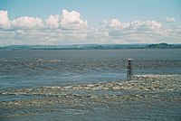
(List of Ramsar Sites)
New Random Display Display All Items(10)