


-
[Marker title]: African Americans in Battle of Lake Erie
[Image]:
[Date dedicated]: September 10, 1996
[Location]: Erie Maritime Museum,150 East Front Street, Erie
[Marker type]: City
[Topics]: African American, Military, War of 1812
(Historical markers) -
[Marker title]: Anthony Wayne
[Image]:
[Date dedicated]: November 1946
[Location]: East 6th Street at Ash Street, Erie
[Marker type]: Roadside
[Topics]: American Revolution, Forts, Military
(Historical markers) -
[Marker title]: Canal Basin
[Image]:
[Date dedicated]: April 5, 1948
[Location]: North end of State State, Erie
[Marker type]: Roadside
[Topics]: Canals, Navigation, Transportation
(Historical markers) -
[Marker title]: Captain C.V. Gridley
[Image]:
[Date dedicated]: November 1946
[Location]: East Lake Road, Erie
[Marker type]: Roadside
[Topics]: Military, Military Post-Civil War
(Historical markers) -
[Marker title]: Captain Daniel Dobbins
[Image]:
[Date dedicated]: September 13, 2003
[Location]: Dobbins Landing, foot of State Street, Erie42°08′16″N 80°05′27″W / 42.13768°N 80.09075°W / 42.13768; -80.09075 (Captain Daniel Dobbins)
[Marker type]: Roadside
[Topics]: George Washington, Military, War of 1812
(Historical markers) -
[Marker title]: Cashier's House
[Image]: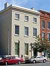
[Date dedicated]: 1980
[Location]: 417 State Street, Erie42°07′52″N 80°05′10″W / 42.131°N 80.0862°W / 42.131; -80.0862 (Cashier's House)
[Marker type]: Roadside
[Topics]: Buildings, Business & Industry, Houses & Homesteads
(Historical markers) -
[Marker title]: Circus History
[Image]:
[Date dedicated]: August 21, 1974
[Location]: US 20 at the Diamond in Girard42°00′00″N 80°19′01″W / 42.00007°N 80.31697°W / 42.00007; -80.31697 (Circus History)
[Marker type]: Roadside
[Topics]: Performers
(Historical markers) -
[Marker title]: Climax Locomotives
[Image]:
[Date dedicated]: May 17, 1987
[Location]: PA 77 at south end of Corry41°55′11″N 79°38′38″W / 41.91962°N 79.64378°W / 41.91962; -79.64378 (Climax Locomotives)
[Marker type]: Roadside
[Topics]: Business & Industry, Railroads, Transportation
(Historical markers) -
[Marker title]: Col. Philip Cochran
[Image]:
[Date dedicated]: November 11, 2001
[Location]: Erie County World War II Memorial,State Street and Glenwood Parkway, Erie
[Marker type]: Roadside
[Topics]: Military, Military Post-Civil War
(Historical markers) -
[Marker title]: Col. Strong Vincent
[Image]:
[Date dedicated]: May 1, 1994
[Location]: Northeast corner of High Street and 1st Street, Waterford41°56′25″N 79°58′58″W / 41.94037°N 79.98285°W / 41.94037; -79.98285 (Col. Strong Vincent)
[Marker type]: Roadside
[Topics]: Civil War, Military
(Historical markers) -
[Marker title]: Colt's Station
[Image]:
[Date dedicated]: October 29, 1951
[Location]: PA 89 at PA 430, Greenfield Township42°07′08″N 79°49′28″W / 42.11883°N 79.82435°W / 42.11883; -79.82435 (Colt's Station)
[Marker type]: Roadside
[Topics]: Government & Politics, Government & Politics 18th Century, Navigation, Transportation
(Historical markers) -
[Marker title]: Corry State Fish Hatchery
[Image]:
[Date dedicated]: July 15, 2010
[Location]: 13365 US 6, Corry41°55′51″N 79°40′16″W / 41.93089°N 79.67114°W / 41.93089; -79.67114 (Corry State Fish Hatchery)
[Marker type]: Roadside
[Topics]: Environment, Government & Politics 20th Century, Sports
(Historical markers) -
[Marker title]: Creation of the Pennsylvania Game Commission
[Image]:
[Date dedicated]: July 24, 2008
[Location]: Northwest corner of Corry City Park, at the intersection of North Center and Smith Streets
[Marker type]: Roadside
[Topics]: Environment, Government & Politics 20th Century
(Historical markers) -
[Marker title]: Drake Well Park
[Image]:
[Date dedicated]: November 20, 1946
[Location]: PA 8 just south of Union City41°53′22″N 79°50′50″W / 41.88958°N 79.84712°W / 41.88958; -79.84712 (Drake Well Park)
[Marker type]: Roadside
[Topics]: Business & Industry, Oil & Gas
(Historical markers) -
[Marker title]: Edinboro State College
[Image]:
[Date dedicated]: May 31, 1968
[Location]: US 6N at the campus in Edinboro41°52′44″N 80°06′58″W / 41.8788°N 80.11615°W / 41.8788; -80.11615 (Edinboro State College)
[Marker type]: City
[Topics]: Education
(Historical markers) -
[Marker title]: Edinboro State Teachers College
[Image]:
[Date dedicated]: May 31, 1968
[Location]: PA 99 in front of college, Edinboro (Missing)
[Marker type]: City
[Topics]: Education
(Historical markers) -
[Marker title]: Erie
[Image]:
[Date dedicated]: November 1, 1946
[Location]: US 20, west of Erie
[Marker type]: Roadside
[Topics]: Cities & Towns, Early Settlement, Forts, Military
(Historical markers) -
[Marker title]: Erie
[Image]:
[Date dedicated]: November 1, 1946
[Location]: US 20, east of Erie
[Marker type]: Roadside
[Topics]: Cities & Towns, Forts, Military, War of 1812
(Historical markers) -
[Marker title]: Erie
[Image]:
[Date dedicated]: November 1, 1946
[Location]: US 19, south of Erie42°02′37″N 80°04′28″W / 42.04369°N 80.0745°W / 42.04369; -80.0745 (Erie)
[Marker type]: Roadside
[Topics]: Cities & Towns, Forts, Military, War of 1812
(Historical markers) -
[Marker title]: Erie County
[Image]: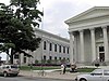
[Date dedicated]: August 21, 1981
[Location]: County Courthouse,West 6th Street between Peach] and Sassafras Streets, Erie
[Marker type]: City
[Topics]: Government & Politics, Government & Politics 19th Century, Military, Native American
(Historical markers) -
[Marker title]: Erie Extension Canal
[Image]:
[Date dedicated]: April 30, 1948
[Location]: PA 18 at Platea41°57′05″N 80°19′45″W / 41.95135°N 80.3291°W / 41.95135; -80.3291 (Erie Extension Canal)
[Marker type]: Roadside
[Topics]: Canals, Navigation, Transportation
(Historical markers) -
[Marker title]: Erie Extension Canal
[Image]:
[Date dedicated]: April 30, 1948
[Location]: US 20 at Asbury Road, Millcreek Township42°04′18″N 80°10′57″W / 42.07158°N 80.18237°W / 42.07158; -80.18237 (Erie Extension Canal)
[Marker type]: Roadside
[Topics]: Canals, Navigation, Transportation
(Historical markers) -
[Marker title]: Erie Land Lighthouse
[Image]: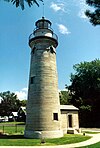
[Date dedicated]: June 19, 2004
[Location]: At the site of the lighthouse, 2 Lighthouse Street, Erie
[Marker type]: City
[Topics]: Buildings, Navigation
(Historical markers) -
[Marker title]: Flagship Niagara
[Image]: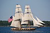
[Date dedicated]: 1948
[Location]: At property on State Street, Erie
[Marker type]: Roadside
[Topics]: Military, War of 1812
(Historical markers) -
[Marker title]: Fort Le Boeuf (Plaque)
[Image]:
[Date dedicated]: August 1, 1922
[Location]: US 19, opposite Fort Le Boeuf Museum, Waterford41°56′24″N 79°58′59″W / 41.94008°N 79.98297°W / 41.94008; -79.98297 (Fort Le Boeuf - PLAQUE)
[Marker type]: Plaque
[Topics]: Forts, French & Indian War, George Washington, Military
(Historical markers) -
[Marker title]: Fort LeBoeuf
[Image]:
[Date dedicated]: November 1, 1946
[Location]: US 19 in Waterford41°56′25″N 79°58′57″W / 41.94015°N 79.98262°W / 41.94015; -79.98262 (Fort LeBoeuf)
[Marker type]: Roadside
[Topics]: Forts, French & Indian War, Military, Native American
(Historical markers) -
[Marker title]: Fort LeBoeuf Memorial
[Image]:
[Date dedicated]: September 19, 1951
[Location]: Property on US 19, Waterford41°56′25″N 79°58′58″W / 41.94037°N 79.98275°W / 41.94037; -79.98275 (Fort LeBoeuf Memorial)
[Marker type]: Roadside
[Topics]: Forts, French & Indian War, George Washington, Military
(Historical markers) -
[Marker title]: Fort Presque Isle
[Image]:
[Date dedicated]: October 1, 1946
[Location]: 6th and Parade Streets, Erie42°07′57″N 80°04′37″W / 42.1326°N 80.07692°W / 42.1326; -80.07692 (Fort Presque Isle)
[Marker type]: Roadside
[Topics]: Forts, French & Indian War, Military, Native American, Roads
(Historical markers) -
[Marker title]: French Creek
[Image]:
[Date dedicated]: November 1, 1946
[Location]: US 19, slightly north of US 6, south of Waterford41°53′05″N 79°59′58″W / 41.88482°N 79.99943°W / 41.88482; -79.99943 (French Creek)
[Marker type]: Roadside
[Topics]: Early Settlement, Ethnic & Immigration, George Washington, Transportation
(Historical markers) -
[Marker title]: George Washington
[Image]:
[Date dedicated]: November 1, 1946
[Location]: US 19, at George Washington Memorial Park, Waterford41°56′24″N 79°58′58″W / 41.94007°N 79.98282°W / 41.94007; -79.98282 (George Washington)
[Marker type]: Roadside
[Topics]: French & Indian War, George Washington, Government & Politics, Government & Politics 18th Century, Military
(Historical markers) -
[Marker title]: Harry Kellar (1849–1922)
[Image]:
[Date dedicated]: May 9, 2008
[Location]: Griswold Park, south side of West 13th Street, between Peach and Sassafras Streets, Erie
[Marker type]: Roadside
[Topics]: Performers, Professions & Vocations
(Historical markers) -
[Marker title]: Harry T. Burleigh
[Image]:
[Date dedicated]: February 21, 1952
[Location]: East 6th Street, Erie
[Marker type]: Roadside
[Topics]: African American, Music & Theater, Performers
(Historical markers) -
[Marker title]: Ida M. Tarbell
[Image]:
[Date dedicated]: September 28, 1950
[Location]: PA 8 near Hatch Hollow Road, southwest of Wattsburg41°57′51″N 79°51′06″W / 41.9641°N 79.85165°W / 41.9641; -79.85165 (Ida M. Tarbell)
[Marker type]: Roadside
[Topics]: Abraham Lincoln, Oil & Gas, Women, Writers
(Historical markers) -
[Marker title]: John Nelson (1917–1959)
[Image]:
[Date dedicated]: September 18, 2004
[Location]: 3923 Main Street, Lawrence Park Township
[Marker type]: City
[Topics]: Civil Rights, Government & Politics 20th Century, Labor
(Historical markers) -
[Marker title]: Joshua M. Merrill (1828–1904)
[Image]:
[Date dedicated]: July 24, 2004
[Location]: Between 19 and 37 North Center Street, Corry
[Marker type]: Roadside
[Topics]: Invention, Oil & Gas, Professions & Vocations
(Historical markers) -
[Marker title]: LP Gas Industry
[Image]:
[Date dedicated]: May 17, 1962
[Location]: US 19 at square in Waterford (Missing)
[Marker type]: Roadside
[Topics]: Business & Industry, Oil & Gas
(Historical markers) -
[Marker title]: Old Custom House
[Image]:
[Date dedicated]: November 1, 1946
[Location]: State Street, Erie (Missing)
[Marker type]: Roadside
[Topics]: Buildings, Business & Industry, Houses & Homesteads
(Historical markers) -
[Marker title]: Old French Road
[Image]:
[Date dedicated]: November 1, 1946
[Location]: Old French Road, south of Erie42°05′32″N 80°03′26″W / 42.09218°N 80.05717°W / 42.09218; -80.05717 (Old French Road)
[Marker type]: Roadside
[Topics]: Native American, Paths & Trails, Roads, Transportation
(Historical markers) -
[Marker title]: Old State Line
[Image]:
[Date dedicated]: November 1946
[Location]: PA 99 at McKean
[Marker type]: Roadside
[Topics]: Government & Politics, Government & Politics 18th Century
(Historical markers) -
[Marker title]: Old State Line
[Image]:
[Date dedicated]: November 1, 1946
[Location]: West Lake Road at Happy Valley Road, Springfield Township41°59′59″N 80°24′20″W / 41.99983°N 80.40553°W / 41.99983; -80.40553 (Old State Line)
[Marker type]: Roadside
[Topics]: Government & Politics, Government & Politics 18th Century
(Historical markers) -
[Marker title]: Old State Line
[Image]:
[Date dedicated]: November 1, 1946
[Location]: Main Street at Wattsburg41°59′57″N 79°48′40″W / 41.99925°N 79.81098°W / 41.99925; -79.81098 (Old State Line)
[Marker type]: Roadside
[Topics]: Government & Politics, Government & Politics 18th Century
(Historical markers) -
[Marker title]: Old State Line
[Image]:
[Date dedicated]: November 1946
[Location]: US 19, Waterford
[Marker type]: Roadside
[Topics]: Government & Politics, Government & Politics 18th Century
(Historical markers) -
[Marker title]: Old State Line
[Image]:
[Date dedicated]: November 1946
[Location]: US 20 at Girard
[Marker type]: Roadside
[Topics]: Government & Politics, Government & Politics 18th Century
(Historical markers) -
[Marker title]: Otto Maya
[Image]:
[Date dedicated]: August 17, 2002
[Location]: 10th and State Streets, Erie (Missing)
[Marker type]: Roadside
[Topics]: Sports
(Historical markers) -
[Marker title]: Paul Allman Siple (1908–1968)
[Image]:
[Date dedicated]: October 14, 2007
[Location]: Plaza at Erie Maritime Museum, 150 East Front Street, Erie
[Marker type]: Roadside
[Topics]: Exploration, Invention, Professions & Vocations
(Historical markers) -
[Marker title]: Pennsylvania
[Image]:
[Date dedicated]: April 12, 1949
[Location]: PA 5, at the Pennsylvania–Ohio border (Missing)
[Marker type]: Roadside
[Topics]: Government & Politics, Government & Politics 17th Century, William Penn
(Historical markers) -
[Marker title]: Pennsylvania
[Image]:
[Date dedicated]: April 12, 1949
[Location]: US 20, at the Pennsylvania–Ohio border41°56′41″N 80°31′00″W / 41.9446°N 80.51673°W / 41.9446; -80.51673 (Pennsylvania)
[Marker type]: Roadside
[Topics]: Government & Politics, Government & Politics 17th Century, William Penn
(Historical markers) -
[Marker title]: Pennsylvania
[Image]:
[Date dedicated]: April 12, 1949
[Location]: At I-90 Welcome Center, just west of Pennsylvania–New York border
[Marker type]: Roadside
[Topics]: Government & Politics, Government & Politics 17th Century, William Penn
(Historical markers) -
[Marker title]: Perry's Shipyards
[Image]:
[Date dedicated]: November 1946
[Location]: 6th and Cascade Streets, Erie
[Marker type]: Roadside
[Topics]: Business & Industry, Military
(Historical markers) -
[Marker title]: Presque Isle Portage
[Image]:
[Date dedicated]: November 1, 1946
[Location]: Peach Street near Lane Road, north of Waterford41°58′50″N 80°00′55″W / 41.98068°N 80.0154°W / 41.98068; -80.0154 (Presque Isle Portage)
[Marker type]: Roadside
[Topics]: Native American, Paths & Trails, Roads, Transportation
(Historical markers) -
[Marker title]: Sr. Bernard Sheridan
[Image]:
[Date dedicated]: September 26, 2003
[Location]: Saint Vincent Hospital, 232 West 25th Street, Erie42°06′39″N 80°04′39″W / 42.1108°N 80.0775°W / 42.1108; -80.0775 (Sr. Bernard Sheridan)
[Marker type]: City
[Topics]: Education, Medicine & Science, Professions & Vocations, Women
(Historical markers) -
[Marker title]: St. James A. M. E. Church
[Image]:
[Date dedicated]: 1994
[Location]: East 12th Street at Holland Street in Erie
[Marker type]: City
[Topics]: African American, Religion
(Historical markers) -
[Marker title]: U.S.S. Wolverine
[Image]:
[Date dedicated]: September 3, 1953
[Location]: North end of State Street, Erie
[Marker type]: City
[Topics]: Civil War, Military
(Historical markers)
New Random Display Display All Items(53)