-
[Type]: Tree
[Symbol]: Delonix regia
[Year]: 1979
[Image]: 
-
[Type]: Quarter
[Symbol]: Quarter of the Northern Mariana Islands
[Year]: November 30, 2009
[Image]: 
-
[Type]: License Plate
[Symbol]: License Plate of the Northern Mariana Islands
[Year]: 1989
[Image]: 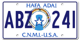
-
[Type]: Nickname
[Symbol]: Nicknames:Håfa Adai (a Chamorro phrase; in English, it is "Hello") (currently used on Northern Mariana Islands license plates)
America's Best Kept Secret
[Year]:
[Image]:
-
[Type]: Seal
[Symbol]: The Seal of the Northern Mariana Islands
[Year]: 1981
[Image]: 
-
[Type]: Song
[Symbol]: "Gi Talo Gi Halom Tasi"
[Year]: 1996
[Image]:
New Random Display
Display All Items(9)
About This Tool
The Northern Mariana Islands is located in the Western Pacific, 50 kilometers east from the Mariana Trench, 2,995 kilometers west from Shanghai, 40 kilometers south from Guam, and 2,335 kilometers north from Tokyo, Japan. Tourism is the country’s pillar industries, and further drive the catering, services and other industries.
The indigenous Chamorro people began living on the Mariana Islands as early as 3,500 years ago. The Northern Mariana Islands first adopted the blue flag as a symbol of the island in July 1985. Since then, 9 different symbols have been changed, including badges, nicknames, birds, Plumeria, etc. . The random tool records the variations of these symbols in detail, including when they were first used, reference images, and specific symbols. Generator often helps you gain a better understanding of the island.
Click the "Display All Items" button and you will get a list of Northern Mariana Islands territorial symbols.


