


-
[Name]: William Bakewell
[Image]: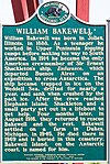
[Location]: 9812 US 41
[City]: Skandia Township
[Listing date]: November 26, 2010
(Current listings) -
[Name]: Bishop Baraga House
[Image]:
[Location]: 615 South Fourth Street
[City]: Marquette
[Listing date]: February 19, 1958
(Current listings) -
[Name]: Big Bay Point Light Station†
[Image]:
[Location]: 3 Lighthouse Road (off Lake Independence Road)
[City]: Big Bay
[Listing date]: May 19, 1988
(Current listings) -
[Name]: Birthplace of Skiing in America Informational Designation
[Image]:
[Location]: US 41/M-28, between 2nd and 3rd streets
[City]: Ishpeming
[Listing date]: January 19, 1957
(Current listings) -
[Name]: Breitung Hotel (destroyed by fire)
[Image]:
[Location]: 111 South Pioneer Avenue
[City]: Negaunee
[Listing date]: June 20, 1985
(Current listings) -
[Name]: John Burt House
[Image]: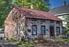
[Location]: 220 Craig Street
[City]: Marquette
[Listing date]: February 19, 1958
(Current listings) -
[Name]: Burt's Discovery of Iron Ore Informational Site
[Image]: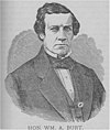
[Location]: Iron Street
[City]: Negaunee
[Listing date]: February 18, 1956
(Current listings) -
[Name]: Carnegie Public Library
[Image]:
[Location]: 317 Main Street
[City]: Ishpeming
[Listing date]: January 18, 1980
(Current listings) -
[Name]: Chocolay River Boundary Line Informational Site
[Image]:
[Location]: West of US 41/M-28; T47N, R24W
[City]: Marquette
[Listing date]: August 23, 1956
(Current listings) -
[Name]: City Water Works
[Image]:
[Location]: 300 North Lakeshore Boulevard
[City]: Marquette
[Listing date]: April 24, 1981
(Current listings) -
[Name]: Cleveland Iron Ore Company Informational Site
[Image]:
[Location]: 504 Spruce Street
[City]: Marquette
[Listing date]: February 17, 1965
(Current listings) -
[Name]: Cliffs Shaft Mine†
[Image]:
[Location]: 501 West Euclid Street
[City]: Ishpeming
[Listing date]: March 14, 1973
(Current listings) -
[Name]: Samuel Cohodas Lodge†
[Image]:
[Location]: Off US 41, at east end of Lake Michigamme
[City]: Michigamme Township
[Listing date]: March 15, 1990
(Current listings) -
[Name]: Dandelion Cottage
[Image]:
[Location]: 440 East Arch Street
[City]: Marquette
[Listing date]: August 20, 1992
(Current listings) -
[Name]: Emanuel Evangelical Lutheran Church
[Image]: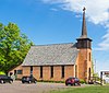
[Location]: 9812 US 41
[City]: Skandia
[Listing date]: November 26, 1985
(Current listings) -
[Name]: Father Marquette Park Informational Designation
[Image]:
[Location]: 501 South Front Street
[City]: Marquette
[Listing date]: December 5, 1986
(Current listings) -
[Name]: Grace Episcopal Church Complex
[Image]:
[Location]: 120 East Canda Street
[City]: Ishpeming
[Listing date]: April 18, 1983
(Current listings) -
[Name]: Gwinn Clubhouse
[Image]:
[Location]: 165 North Maple Street
[City]: Gwinn
[Listing date]: January 18, 1980
(Current listings) -
[Name]: Gwinn Model Town† Informational Designation
[Image]:
[Location]: Nordeen Park, North Pine Street
[City]: Gwinn
[Listing date]: 2008
(Current listings) -
[Name]: Hotel Janzen
[Image]:
[Location]: 146 West Spring Street
[City]: Marquette
[Listing date]: May 8, 1984
(Current listings) -
[Name]: Independence Hotel
[Image]:
[Location]: 400 Bensinger
[City]: Big Bay
[Listing date]: May 21, 1985
(Current listings) -
[Name]: Iron Cliffs Company
[Image]: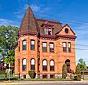
[Location]: 101 Pioneer Avenue
[City]: Negaunee
[Listing date]: November 21, 1975
(Current listings) -
[Name]: Iron Mountain Railway Informational Designation
[Image]: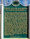
[Location]: Washington Street at Cove's Hill
[City]: Marquette
[Listing date]: February 18, 1956
(Current listings) -
[Name]: Ishpeming Municipal Building†
[Image]: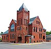
[Location]: 100 East Division Street
[City]: Ishpeming
[Listing date]: January 18, 1980
(Current listings) -
[Name]: Jackson Iron Company Site† (20MQ21)
[Image]:
[Location]: Forge Road, north of Negaunee city limits off County Road 492
[City]: Negaunee
[Listing date]: February 18, 1956
(Current listings) -
[Name]: Jackson Mine†
[Image]:
[Location]: Northwest of intersection of Business M-28 and Cornish Town Road
[City]: Negaunee
[Listing date]: February 18, 1956
(Current listings) -
[Name]: Marquette City Hall†
[Image]:
[Location]: 204 Washington Street
[City]: Marquette
[Listing date]: October 7, 1974
(Current listings) -
[Name]: Marquette County Courthouse†
[Image]: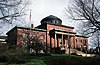
[Location]: 400 Third Street
[City]: Marquette
[Listing date]: August 6, 1976
(Current listings) -
[Name]: Marquette County Poor House (demolished)
[Image]:
[Location]: Division Street and Pioneer Road
[City]: Marquette
[Listing date]: October 23, 1986
(Current listings) -
[Name]: Marquette County Savings Bank†
[Image]:
[Location]: 125 West Washington Street
[City]: Marquette
[Listing date]: June 18, 1976
(Current listings) -
[Name]: Marquette Iron Range Informational Designation
[Image]:
[Location]: Miners Park, at US 41/M-28 and Maple Street
[City]: Negaunee
[Listing date]: July 19, 1956
(Current listings) -
[Name]: Marquette Ore Docks
[Image]:
[Location]: Lake Shore Boulevard, Presque Isle Harbor
[City]: Marquette
[Listing date]: September 25, 1956
(Current listings) -
[Name]: Julian T. Mason House
[Image]:
[Location]: 425 East Ohio Street
[City]: Marquette
[Listing date]: June 16, 1972
(Current listings) -
[Name]: Mather Inn†
[Image]:
[Location]: 107 Canda Street
[City]: Ishpeming
[Listing date]: June 18, 1976
(Current listings) -
[Name]: Henry R. and Mary Hewitt Mather House†
[Image]:
[Location]: 450 Ridge Street
[City]: Marquette
[Listing date]: May 18, 1971
(Current listings) -
[Name]: Negaunee City Hall
[Image]:
[Location]: Corner of Silver and Jackson streets
[City]: Negaunee
[Listing date]: June 15, 1979
(Current listings) -
[Name]: Northern Michigan University Informational Site
[Image]:
[Location]: Northern Michigan University campus
[City]: Marquette
[Listing date]: January 19, 1957
(Current listings) -
[Name]: Northern Michigan University: Kaye Hall Complex (all structures demolished)
[Image]:
[Location]: Presque Isle Avenue, campus of Northern Michigan University
[City]: Marquette
[Listing date]: April 14, 1972
(Current listings) -
[Name]: Pioneer Road Cemetery (closed)
[Image]:
[Location]: Pioneer Road and M-553
[City]: Marquette
[Listing date]: October 27, 1983 Markers moved to Holy Cross Cemetery 1400 Wright St.
(Current listings) -
[Name]: Point of Beginning of First Survey of Upper Peninsula Railroad Informational Site
[Image]:
[Location]: Ellwood Mattson Lower Harbor Park at Marquette Harbor, Lake Superior
[City]: Marquette
[Listing date]: January 16, 1976
(Current listings) -
[Name]: Stannard Rock Lighthouse†
[Image]:
[Location]: 45 miles (72 km) north of Marquette
[City]: Lake Superior
[Listing date]: April 23, 1971
(Current listings) -
[Name]: State House of Correction and Branch Prison†
[Image]: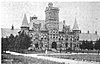
[Location]: Off US 41/M-28
[City]: Marquette
[Listing date]: December 18, 1974
(Current listings) -
[Name]: Union Railroad Depot
[Image]:
[Location]: 499 Rail Street
[City]: Negaunee
[Listing date]: September 17, 1981
(Current listings)
New Random Display Display All Items(43)