


-
[Name]: Allen House
[Image]:
[Location]: 126 E. Water Street
[City]: Sault Ste. Marie
[Listing date]: October 1, 1971
(Current listings) -
[Name]: Bishop Frederick Baraga House
[Image]: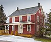
[Location]: 501 E. Water Street
[City]: Sault Ste. Marie
[Listing date]: February 19, 1958
(Current listings) -
[Name]: Bay City House Hotel
[Image]: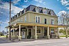
[Location]: 501 East Portage
[City]: Sault Ste. Marie
[Listing date]: March 22, 1983
(Current listings) -
[Name]: Birch Lodge†
[Image]:
[Location]: 21830 S. Birch Lodge Dr.
[City]: Trout Lake
[Listing date]: November 20, 1987
(Current listings) -
[Name]: Carnegie Library
[Image]: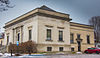
[Location]: 315 Armory Place
[City]: Sault Ste. Marie
[Listing date]: January 8, 1981
(Current listings) -
[Name]: Central Methodist Church†
[Image]:
[Location]: 111 East Spruce Street
[City]: Sault Ste. Marie
[Listing date]: June 17, 1993
(Current listings) -
[Name]: Church of Our Saviour, Friend of Children†
[Image]:
[Location]: North Shore Road, Sugar Island, Payment Settlement
[City]: Sugar Island Township
[Listing date]: January 19, 1978
(Current listings) -
[Name]: Elmwood†
[Image]:
[Location]: 435 E. Water Street
[City]: Sault Ste. Marie
[Listing date]: September 25, 1956
(Current listings) -
[Name]: Emerson Informational Site
[Image]:
[Location]: M-123
[City]: Paradise vicinity
[Listing date]: August 3, 1979
(Current listings) -
[Name]: Federal Building†
[Image]:
[Location]: 209 East Portage Avenue
[City]: Sault Ste. Marie
[Listing date]: December 14, 1976
(Current listings) -
[Name]: Fort Brady (20CH51)†
[Image]:
[Location]: Bounded by the C.O.E. Service Plaza on the north, Portage St. on the south, Brady St. on the east, and Bingham St. on the west
[City]: Sault Ste. Marie
[Listing date]: August 23, 1956
(Current listings) -
[Name]: Fort Colyer†
[Image]:
[Location]: West end of Drummond Island (northwest shore of Whitney Bay), Sec. 1, T41N, R4E
[City]: De Tour Village vicinity
[Listing date]: November 27, 1956
(Current listings) -
[Name]: Fort Repentigny Informational Designation
[Image]:
[Location]: Park Place and River Street
[City]: Sault Ste. Marie
[Listing date]: February 18, 1956
(Current listings) -
[Name]: Governor Cass and the Indians Informational Designation
[Image]:
[Location]: Foot of Bingham Avenue, Brady Field
[City]: Sault Ste. Marie
[Listing date]: February 18, 1956
(Current listings) -
[Name]: Johnston Homestead Informational Site
[Image]:
[Location]: Neebish Island
[City]: Barbeau vicinity
[Listing date]: April 4, 1975
(Current listings) -
[Name]: John Johnston House†
[Image]:
[Location]: 415 East Waters Street
[City]: Sault Ste. Marie
[Listing date]: February 19, 1958
(Current listings) -
[Name]: Lake Superior State College
[Image]:
[Location]: West Easterday Road near the intersection with Meridian Road
[City]: Sault Ste. Marie
[Listing date]: February 21, 1975
(Current listings) -
[Name]: Larke Road Informational Designation
[Image]:
[Location]: Three Mile Road
[City]: Sault Ste. Marie
[Listing date]: January 13, 1982
(Current listings) -
[Name]: Legends of Hiawatha
[Image]:
[Location]: Tahquamenon Falls State Park
[City]: Whitefish Township
[Listing date]: February 12, 1959
(Current listings) -
[Name]: Louis W. Hill†
[Image]:
[Location]: Old Union Carbide Dock, foot of Johnstone Street
[City]: Sault Ste. Marie
[Listing date]: October 1, 1971
(Current listings) -
[Name]: Methodist Indian Mission Informational Site
[Image]: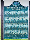
[Location]: 1420 Riverside Drive
[City]: Sault Ste. Marie
[Listing date]: October 9, 1978
(Current listings) -
[Name]: New Fort Brady†
[Image]:
[Location]: Lake Superior State College campus
[City]: Sault Ste. Marie
[Listing date]: July 17, 1970
(Current listings) -
[Name]: New Pine Grove Cemetery
[Image]:
[Location]: 5750 S. Mackinac Trail
[City]: Sault Ste. Marie
[Listing date]: July 18, 1996
(Current listings) -
[Name]: Governor Chase Salmon Osborn Informational Designation
[Image]:
[Location]: Historic Walkway of Sault Ste. Marie
[City]: Sault Ste. Marie
[Listing date]: April 10, 1986
(Current listings) -
[Name]: Saint Mary's Falls Canal†
[Image]:
[Location]: Canal Park, Portage Avenue
[City]: Sault Ste. Marie
[Listing date]: February 12, 1959
(Current listings) -
[Name]: Saint Mary's Pro-Cathedral†
[Image]: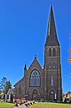
[Location]: 320 E Portage Avenue
[City]: Sault Ste. Marie
[Listing date]: July 20, 1989
(Current listings) -
[Name]: Sault Ste. Marie Informational Designation
[Image]:
[Location]: Rest Area on I-75, 5 miles south of Sault Ste. Marie
[City]: Sault Ste. Marie
[Listing date]: February 18, 1956
(Current listings) -
[Name]: Shelldrake Informational Site
[Image]:
[Location]: Whitefish Point Rd
[City]: Paradise vicinity
[Listing date]: August 3, 1979
(Current listings) -
[Name]: Whitefish Point Lighthouse†
[Image]:
[Location]: Whitefish Point, 6 miles NE of Shelldrake on Whitefish Road
[City]: Shelldrake vicinity
[Listing date]: February 22, 1974
(Current listings) -
[Name]: Whitefish Point Post Office
[Image]:
[Location]: 16878 N. Whitefish Point Rd.
[City]: Paradise vicinity
[Listing date]: August 3, 1979
(Current listings) -
[Name]: Whitefish Township Informational Designation
[Image]:
[Location]: S.R. 48 M-123
[City]: Paradise
[Listing date]: March 15, 1990
(Current listings)
New Random Display Display All Items(31)