


-
(#1) Pearl Harbor
- Hawaii, USA
The attack on Pearl Harbor on December 7, 1941, resulted in the loss of more than 2,400 lives. As a surprise move by Japan, the early morning airborne offensive destroyed numerous American naval vessels and airplanes. The USS Arizona, a battleship in port at the Hawaii base, sank with more than 1,000 sailors on board and continues to leak oil into the Pacific Ocean. In the immediate aftermath of the Pearl Harbor attack, the United States officially declared war on Japan and entered World War Two.
-
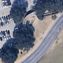
(#2) Gettysburg National Military Park
- Gettysburg, Pennsylvania, USA
Considered a turning point during the American Civil War, the Battle of Gettysburg took place over two days in July 1863. The Battle of Gettysburg was a victory for the Union, one that signaled a demoralizing decline for the Confederacy. Gettysburg, located in Pennsylvania, was also the site of President Abraham Lincoln's "Gettysburg Address," delivered later the same year.
-
(#3) Auschwitz-Birkenau
As the largest Nazi concentration and extermination camp, Auschwitz-Birkenau was the site of more than 1.1 million murders during World War Two. Auschwitz-Birkenau was opened in 1940 and, as a focal point for the "Final Solution," featured facilities for prisoners of all ages. Alongside forced labor, torture, and executions, prisoners at Auschwitz-Birkenau were subjected to medical experiments, starvation, and countless other atrocities.
-
(#4) Tiananmen Square
In 1989, a group of students staged a protest at Tiananmen Square in Beijing, China. Tiananmen - the "gate of heavenly peace" - was located near the Forbidden City and, as China grieved the loss of leader Hu Yaobang, was home to demonstrations calling for democratic reforms. By June 4 and 5, the Chinese government took violent measures to end the protests, opening fire into crowds in Tiananmen Square.
-
(#5) Branch Davidian Compound
Located near Waco, Texas, the Branch Davidian complex erupted in flames when FBI forced its way into the facility on April 19, 1993. Cult leader David Koresh and the Branch Davidians held a 51-day standoff against federal authorities, initially resisting efforts of the Bureau of Alcohol, Tobacco, and Firearms to investigate the presence of contraband weapons. By the time the standoff came to an end, 75 members of the religious group were dead.
-
(#6) Yorktown Battlefield Colonial National Historic Park
A pivotal battle in the American Revolution, the Battle of Yorktown pitted General George Washington against British forces in what would be the final battle of the war. Fighting at Yorktown, located in Virginia, ended when British General Charles Cornwallis surrendered on October 19, 1781 after weeks of fighting. The Revolutionary War was, for all intents and purposes, over, but it did not officially end until the Treaty of Paris in 1783.
-
(#7) World Trade Center
The World Trade Center in Manhattan, location of terror attacks in 1993 and 2001, is now home to the Freedom Tower, a building that exceeds the height of the Twin Towers that previously stood on the site. A memorial located nearby features reflecting pools and engraved panels commemorating the nearly 3,000 victims who died in 1993 and 2001.
-
(#8) The Grassy Knoll, Dallas, Texas
Located near Dealey Plaza in Dallas, Texas, the Grassy Knoll has been associated with conspiracy theories about the assassination of President John F. Kennedy since 1963. When Kennedy was shot on November 22, there were assertions that the gunman, Lee Harvey Oswald, did not work alone. Rather, Oswald - perched at a window in the Texas School Book Depository - had help from a second shooter on the Grassy Knoll.
-
(#9) Chernobyl
- Kiev Oblast, Ukraine
The accident at the Chernobyl Nuclear Power Plant in the Ukraine in April 1986 released massive amounts of radiation into the environment. As the contamination spread, evacuations and clean up efforts couldn't prevent deaths, health effects, and irreversible damage to the flora and fauna of the region. The nuclear reactor was encased in cement in May 1986, with repeated efforts to stabilize and strengthen the enclosure taking place in the decades since the disaster first occurred.
-
(#10) Three Mile Island
As the location of the worst nuclear disaster in American history, Three Mile Island sits on a small patch of land in the Susquehanna River near Harrisburg, Pennsylvania. In March 1979, one of the nuclear reactors overheated, causing a meltdown that released radioactive material into the area. Ultimately, there was relatively little harm caused by the leak, but the incident caused a backlash against nuclear energy in the United States.
-
(#11) Mount Vesuvius
- Europe
When Mount Vesuvius erupted in August 79 CE, the volcano wrought widespread devastation to the cities of Pompeii and Herculaneum. According to accounts, ash, toxic gas, lava, and mud overtook the area, burying the cities where, "People bewailed their own fate or that of their relatives, and there were some who prayed for death in their terror of dying."
-
(#12) Omaha Beach
- Calvados, France
As one of the beaches were Allied forces landed on June 6, 1944, Omaha Beach spans roughly 10 kilometers along the coast of Normandy. Omaha Beach was heavily defended by the Germans and, when waves of American troops hit the shore, they were subjected to relentless gunfire. More than 2,000 Allies died on Omaha Beach during the D-Day invasion.
-
(#13) Berlin Wall Remains
Both a symbolic and functional divide built during the Cold War, the Berlin War was built in 1961. Designed to prevent flight from East Berlin, the concrete fortification featured barbed wire and watchtowers with additional ditches, fencing, patrol roads, and security strips to create an array of obstacles. After the Berlin Wall came down in 1989, Berlin reunified and sections of the 155-kilometer Wall were to bear witness to its place in history.
-
(#14) Watergate Hotel
The site of the 1972 break-in that resulted in a scandal surrounding the Nixon administration, the Watergate Hotel in Washington, DC is part of a larger complex that was once home to the headquarters of the Democratic National Committee. Nixon was implicated in the conspiracy surrounding the Watergate break-in, ultimately leading to his resignation as President of the United States.
-
(#15) Manassas National Battlefield Park
- Virginia, USA
As the location of two battles fought during the American Civil War, the Manassas National Battlefield was the site of some of the most hard-fought fighting of the conflict. The First Battle of Manassas (also called Bull Run) took place in July 1861, while the Second Battle of Manassas was fought the following year. The first signaled to the North that the Civil War would not be a quick conflict, while the second proved to be a decisive victory for the South.
-
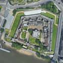
(#16) Tower of London
- London Borough of Tower Hamlets, United Kingdom
Begun under the auspices of William the Conqueror in the late 11th century, the Tower of London remains a historical landmark in the heart of the city. The Tower of London grew to house administrative documents, the Crown Jewels, and other symbols of royal power and prestige - to say nothing of the executions and alleged murders that took place there - as it took on the role of palace and fortress alike.
-
(#17) Midway Atoll
The Battle of Midway, fought at the three small islands that constitute the Midway Atoll, took place in June 1942. The United States Navy was able to defend their stronghold at Midway, in large part thanks to breaking Japanese communication codes. As a result of the American victory, Japan transitioned its battle strategy from offense to defense in the Pacific.
-
(#18) Alcatraz Federal Penitentiary
Alcatraz Island, located in the San Francisco Bay, was home to a federal penitentiary that held the nation's most dangerous prisoners. Alcatraz Federal Penitentiary was active from 1934 to 1963, famed for never having experienced a successful escape. Noted residence of Alcatraz include Al Capone and Robert "Birdman of Alcatraz" Stroud.
-
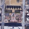
(#19) Alfred P. Murrah Federal Building
- Oklahoma, USA
The bombing at the Alfred P. Murrah Federal Building in Oklahoma City, Oklahoma, on April 19, 1995, resulted in the deaths of 168 people. Hundreds of buildings in the vicinity of the building were damaged in the explosion, an act of domestic terror perpetrated by Timothy McVeigh and Terry Nichols. The site of the bombing is now home to a memorial that features several sections of the razed building.
-
(#20) Mount Everest
- Asia
Mount Everest, the highest mountain in the world, is located near the border of Nepal and Tibet. Since the first climber summitted Mount Everest in 1953, roughly 5,000 people have reached the top. The highest point of Mount Everest sits at 29,028 feet above sea level, a height nearly 220 individuals have died trying to reach.
-
(#21) Gallipoli Peninsula
The Battle of Gallipoli brought Allied forces and their Ottoman counterparts face to face during World War I. Fought at the Gallipoli peninsula in Turkey, the battle was extremely deadly for both sides, with 58,000 soldiers from Britain, Ireland, Australia, and New Zealand, dying alongside 87,000 Ottoman Turks. The entire campaign, which began in April 1915, was abandoned by the Allies in early January 1916.


New Random Displays Display All By Ranking
About This Tool
The satellite historical images of Google Earth can help us remember many things and the maps that we remember also remind us to respect life and nature. Satellite maps record not only some pictures but also these painful and important historical events that are gradually forgotten by people. It is reported that Google used 8 years of history to collect historical photos, including aerial and satellite photos and other sources, and added these photos to the latest version of Google Earth.
Through a slideshow function, users can look back on the history that has happened and understand how certain regions looked like years ago or even decades ago. Our random tool collected 20 Google Earth satellite pictures of these places where historical events happened, such as Pearl Harbor, Berlin Wall, Tower of London, etc.
Our data comes from Ranker, If you want to participate in the ranking of items displayed on this page, please click here.