


-
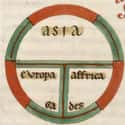
(#1) T-O Map From Isidore Of Seville's 'Etymologies,' Circa 600
Many medieval world maps followed the same general style, known as the T-O map. These maps showed the three known continents in a T-shape, ringed by an O of water - sort of like the Trivial Pursuit wedge of the world. This simplified version of a medieval world map emphasizes the simple shape of the world in its lines.
Asia is shown at the top of the map, with Europe and Africa below. The Mediterranean, the Nile, and the River Don make up the water separating the continents.
This style of map, which didn’t prioritize accuracy, was meant to highlight the harmonious balance between the continents. It was also clearly a religious map: Jerusalem was at the center, and mapmakers often included religiously significant items, such as Noah’s Ark or the Earthly Paradise.
-
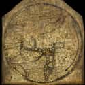
(#8) Hereford Mappa Mundi, Circa 1300
The Hereford mappa mundi shows what the simplified T-O structure looks like with more geographical details. This map, made around 1300, has been in England’s Hereford Cathedral for 700 years, capturing a medieval view of the world. Medieval and biblical history mingle on the map, which includes over 500 illustrations of people, animals, cities, and towns; 15 biblical events; and an array of strange creatures, odd people, and mythological images.
The variety in the Hereford mappa mundi points to its intended use: It is a visual chronicle of knowledge, mixing time and space to stun viewers with the scope of the world. And it’s no mistake that the Hereford mappa mundi is housed in a cathedral - it’s also a religious object meant to educate Christians on their place in the world.
-
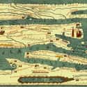
(#3) Tabula Peutingeriana, 1265
The Tabula Peutingeriana, an itinerary map, is a reproduction of a Roman map, showing the highways of the Roman world all the way from England to Sri Lanka. It isn’t to scale and manipulates space to show the road system. Pictured are stopping places, prominent towns, and mountain ranges.
The Tabula Peutingeriana is also massive at 22 feet in length. At that size, it wouldn’t be useful for a road trip, but with 555 cities and 3,500 place names, it is a chronicle of Rome’s reach.
The map’s geographic information dates back to before at least 79 AD, since you can spot Pompeii. The original map has been lost, but we still have a copy thanks to a monk who reproduced it on 11 scrolls in 1265.
-
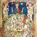
(#2) Psalter World Map, Circa 1265
Just in case the religious nature of the map isn’t clear, the Psalter Map, made in the 1260s, drives the point home by placing a giant image of Jesus on top. This small map, measuring only 6.6 inches high, was painted in a 13th-century copy of the Book of Psalms. In addition to Jesus holding court over the world, the Psalter Map places a large bull's-eye over Jerusalem at the center.
Mythical monstrous people inhabit the right side of the map, while the Red Sea is actually painted red. But these monsters are not just figments of the unknown mapmaker’s imagination: they are based on classical texts like Pliny the Elder’s Natural History. Pliny claimed a North African tribe was “said to have no heads, their mouths and eyes being seated in the breasts.” Here, Pliny’s classical tales mix with biblical knowledge on one map.
-
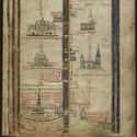
(#4) Itinerary Map By Matthew Paris, Circa 1250s
At first glance, this medieval itinerary map by Matthew Paris doesn’t even look like a map. Instead, it’s a line of castles and buildings crossed by red text and blue waves. The map charts a route from London to the Holy Land, highlighting all the sights along the way. The mapmaker included rivers and hills, alternate routes, and places to stop on a religious pilgrimage.
At the bottom left of the map, you can see Matthew Paris’s depiction of London as a thick city wall ringing a blue church.
Like many medieval maps, this one was not intended to be carried on the road. It was an expensive work of art that may have been used for an imagined pilgrimage - one where the pilgrim never had to leave England.
-
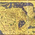
(#10) Tabula Rogeriana, Circa 1154
This map is perhaps the most worldly. The Tabula Rogeriana - Latin for the Book of Roger - was created around 1154 by a Muslim scholar named Al-Idrisi. He was born in North Africa, educated in Islamic Spain, traveled across the known world, and eventually worked for Roger II, the Christian king of Sicily. In the 12th century, Sicily was heavily influenced by Byzantine, Catholic, Muslim, and Viking traditions. The Normans, former Vikings who settled in France, conquered the island’s Arab rulers and claimed it for themselves. Greeks, Romans, Byzantines, Arabs, and Normans had all claimed Sicily.
So it's no surprise that Al-Idrisi created one of the most accurate, complete maps of the known world. Al-Idrisi drew on interviews with dozens of travelers, in addition to authoritative texts.
However, the Tabula Rogeriana is also a product of its time, and the best reminder is the fact that the map places south at the top. For Al-Idrisi, the world he knew best - the Muslim territories of North Africa - was to the south, so it made sense to place it at the top.
New Random Displays Display All By Ranking
About This Tool
In the Middle Ages, people did not have map consciousness. As a new civilized world is being formed, the concept of maps that once existed in the Greco-Roman era is gradually dying out. Although some ancient Roman world maps were preserved until the early Middle Ages, they apparently disappeared as slowly as the dying classical traditions and knowledge, which also led to the production of strange maps at that time.
The knowledge and techniques of scientific mapping were not rediscovered until the 15th and 16th centuries. The random tool shows 12 weird maps of the Middle Ages that you must be interested in.
Our data comes from Ranker, If you want to participate in the ranking of items displayed on this page, please click here.