


-
[Place ID]: 600947
[Image]:
[Listed place]: St Mark's Anglican Church
[Address]: 55 Albion Street
[Coordinates]: 28°12′58″S 152°02′04″E / 28.2160°S 152.0345°E / -28.2160; 152.0345 (St Mark's Anglican Church)
[Notes]: -
[Place ID]: 601505
[Image]:
[Listed place]: Glennie Hall
[Address]: 66 Albion Street
[Coordinates]: 28°13′05″S 152°02′06″E / 28.2181°S 152.035°E / -28.2181; 152.035 (Glennie Hall)
[Notes]: -
[Place ID]: 600525
[Image]:
[Listed place]: Canning Downs Homestead
[Address]: Canning Downs
[Coordinates]: 28°13′22″S 152°03′27″E / 28.2227°S 152.0574°E / -28.2227; 152.0574 (Canning Downs)
[Notes]: -
[Place ID]: 600944
[Image]:
[Listed place]: The Commonage
[Address]: 69A Dragon Street
[Coordinates]: 28°13′07″S 152°01′37″E / 28.2187°S 152.027°E / -28.2187; 152.027 (The Commonage)
[Notes]: -
[Place ID]: 600945
[Image]:
[Listed place]: Pringle Cottage
[Address]: 81 Dragon Street
[Coordinates]: 28°13′13″S 152°01′36″E / 28.2204°S 152.0267°E / -28.2204; 152.0267 (Pringle Cottage)
[Notes]: -
[Place ID]: 600946
[Image]:
[Listed place]: Warwick War Memorial
[Address]: Fitzroy Street
[Coordinates]: 28°12′46″S 152°01′55″E / 28.2129°S 152.032°E / -28.2129; 152.032 (Warwick War Memorial)
[Notes]: -
[Place ID]: 600947
[Image]:
[Listed place]: Warwick East State School
[Address]: 45 Fitzroy Street
[Coordinates]: 28°12′52″S 152°02′21″E / 28.2144°S 152.0392°E / -28.2144; 152.0392 (Warwick East State School)
[Notes]: -
[Place ID]: 601725
[Image]:
[Listed place]: Plumb's Chambers
[Address]: 82 & 84 Fitzroy Street
[Coordinates]: 28°12′51″S 152°01′55″E / 28.2143°S 152.0319°E / -28.2143; 152.0319 (Plumb's Chambers)
[Notes]: -
[Place ID]: 600948
[Image]: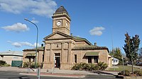
[Listed place]: Warwick Court House
[Address]: 88 Fitzroy Street
[Coordinates]: 28°12′51″S 152°01′52″E / 28.2143°S 152.0312°E / -28.2143; 152.0312 (Warwick Court House)
[Notes]: -
[Place ID]: 600950
[Image]:
[Listed place]: National Hotel
[Address]: 35 Grafton Street
[Coordinates]: 28°13′00″S 152°02′23″E / 28.2168°S 152.0396°E / -28.2168; 152.0396 (National Hotel)
[Notes]: -
[Place ID]: 601756
[Image]:
[Listed place]: Tulloch's Central Stores
[Address]: 110-114 Grafton Street
[Coordinates]: 28°12′58″S 152°01′52″E / 28.2162°S 152.031°E / -28.2162; 152.031 (Tulloch's Central Stores)
[Notes]: -
[Place ID]: 601757
[Image]:
[Listed place]: Warwick Uniting Church
[Address]: 37 Guy Street (corner of Fitzroy Street)
[Coordinates]: 28°12′50″S 152°01′49″E / 28.214°S 152.0302°E / -28.214; 152.0302 (Warwick Uniting Church)
[Notes]: -
[Place ID]: 600951
[Image]:
[Listed place]: Residence, 50 Guy Street
[Address]: 50 Guy Street
[Coordinates]: 28°13′01″S 152°01′50″E / 28.2169°S 152.0305°E / -28.2169; 152.0305 (Residence, 50 Guy Street)
[Notes]: -
[Place ID]: 600952
[Image]:
[Listed place]: St George's Masonic Centre
[Address]: 50A Guy Street
[Coordinates]: 28°13′01″S 152°01′50″E / 28.217°S 152.0305°E / -28.217; 152.0305 (St George's Masonic Centre)
[Notes]: -
[Place ID]: 602497
[Image]:
[Listed place]: Warwick Central State School
[Address]: 55B Guy Street
[Coordinates]: 28°13′03″S 152°01′45″E / 28.2175°S 152.0293°E / -28.2175; 152.0293 (Warwick Central State School)
[Notes]: -
[Place ID]: 600954
[Image]:
[Listed place]: Assembly Hall
[Address]: 8 Locke Street
[Coordinates]: 28°13′34″S 152°01′40″E / 28.226°S 152.0278°E / -28.226; 152.0278 (Assembly Hall, Warwick)
[Notes]: -
[Place ID]: 600953
[Image]:
[Listed place]: Our Lady of Assumption Convent
[Address]: 8 Locke Street
[Coordinates]: 28°13′03″S 152°02′28″E / 28.2174°S 152.0412°E / -28.2174; 152.0412 (Our Lady of Assumption Convent)
[Notes]: -
[Place ID]: 600955
[Image]:
[Listed place]: Warwick railway station
[Address]: Lyons Street
[Coordinates]: 28°13′03″S 152°02′28″E / 28.2174°S 152.0412°E / -28.2174; 152.0412 (Warwick railway station)
[Notes]: -
[Place ID]: 602076
[Image]:
[Listed place]: T J Byrnes Monument
[Address]: Palmerin Street
[Coordinates]: 28°12′58″S 152°01′57″E / 28.2162°S 152.0326°E / -28.2162; 152.0326 (T J Byrnes Monument)
[Notes]: -
[Place ID]: 600960
[Image]:
[Listed place]: Johnson's Building
[Address]: 64-70 Palmerin Street
[Coordinates]: 28°12′54″S 152°01′59″E / 28.2149°S 152.0331°E / -28.2149; 152.0331 (Johnson's Building)
[Notes]: -
[Place ID]: 600961
[Image]:
[Listed place]: Warwick Town Hall
[Address]: 72 Palmerin Street
[Coordinates]: 28°12′56″S 152°02′00″E / 28.2155°S 152.0332°E / -28.2155; 152.0332 (Warwick Town Hall)
[Notes]: -
[Place ID]: 600962
[Image]:
[Listed place]: Criterion Hotel
[Address]: 84 Palmerin Street
[Coordinates]: 28°12′56″S 152°02′00″E / 28.2155°S 152.0332°E / -28.2155; 152.0332 (Criterion Hotel)
[Notes]: -
[Place ID]: 600956
[Image]: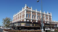
[Listed place]: Barnes and Co. Trading Place (aka Smith & Miller building)
[Address]: 118 Palmerin Street
[Coordinates]: 28°13′03″S 152°01′58″E / 28.2176°S 152.0327°E / -28.2176; 152.0327 (Barnes and Co. Trading Place)
[Notes]: -
[Place ID]: 600957
[Image]:
[Listed place]: Langham Hotel
[Address]: 133 Palmerin Street
[Coordinates]: 28°13′01″S 152°01′55″E / 28.2169°S 152.032°E / -28.2169; 152.032 (Langham Hotel)
[Notes]: -
[Place ID]: 602585
[Image]:
[Listed place]: St Mary's Presbytery
[Address]: 142 Palmerin Street
[Coordinates]: 28°13′08″S 152°01′58″E / 28.2188°S 152.0328°E / -28.2188; 152.0328 (St Mary's Presbytery)
[Notes]: -
[Place ID]: 600958
[Image]:
[Listed place]: First St. Mary's Roman Catholic Church, Warwick
[Address]: 163 Palmerin Street
[Coordinates]: 28°13′09″S 152°01′53″E / 28.2191°S 152.0314°E / -28.2191; 152.0314 (First St. Mary's Roman Catholic Church)
[Notes]: -
[Place ID]: 600959
[Image]:
[Listed place]: Second St Mary's Roman Catholic Church, Warwick
[Address]: 163 Palmerin Street
[Coordinates]: 28°13′09″S 152°01′53″E / 28.2191°S 152.0314°E / -28.2191; 152.0314 (Second St Mary's Roman Catholic Church)
[Notes]: -
[Place ID]: 602199
[Image]:
[Listed place]: Oddfellows Home Hotel
[Address]: Wantley Street
[Coordinates]: 28°13′09″S 152°01′31″E / 28.2191°S 152.0252°E / -28.2191; 152.0252 (Oddfellows Home Hotel)
[Notes]: -
[Place ID]: 600942
[Image]:
[Listed place]: Hillside, Warwick
[Address]: 25 Weewondilla Road
[Coordinates]: 28°12′13″S 152°01′45″E / 28.2036°S 152.0292°E / -28.2036; 152.0292 (Hillside)
[Notes]: -
[Place ID]: 602152
[Image]:
[Listed place]: Warwick General Cemetery
[Address]: Wentworth Street
[Coordinates]: 28°12′36″S 152°00′12″E / 28.2099°S 152.0032°E / -28.2099; 152.0032 (Warwick General Cemetery)
[Notes]: -
[Place ID]: 601772
[Image]:
[Listed place]: Aberfoyle, Warwick
[Address]: 35 Wood Street
[Coordinates]: 28°13′13″S 152°02′05″E / 28.2204°S 152.0346°E / -28.2204; 152.0346 (Aberfoyle)
[Notes]:
New Random Display Display All Items(31)